

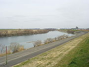
Edo River
Encyclopedia
Kanto region
The is a geographical area of Honshu, the largest island of Japan. The region includes the Greater Tokyo Area and encompasses seven prefectures: Gunma, Tochigi, Ibaraki, Saitama, Tokyo, Chiba, and Kanagawa. Within its boundaries, slightly more than 40 percent of the land area is the Kantō Plain....
of Japan
Japan
Japan is an island nation in East Asia. Located in the Pacific Ocean, it lies to the east of the Sea of Japan, China, North Korea, South Korea and Russia, stretching from the Sea of Okhotsk in the north to the East China Sea and Taiwan in the south...
. It splits from the Tone River
Tone River
The is a river in the Kantō region of Japan. It is in length and has a drainage area of...
at the northernmost tip of Narita City
Narita, Chiba
is a city located in Chiba Prefecture, Japan. It is the site of Narita International Airport, the main international airport serving the Greater Tokyo Area....
, crosses through Nagareyama
Nagareyama, Chiba
is a city located in northern Chiba Prefecture, Japan. As of February 2011, the town had an estimated population of 164,683 and a population density of 4670 persons per km²...
and Matsudo
Matsudo, Chiba
is a city located in northern Chiba Prefecture, Japan. As of February 2011, the city had an estimated population of 484,578 and a population density of 7900 persons per km²...
, and empties into Tokyo Bay
Tokyo Bay
is a bay in the southern Kantō region of Japan. Its old name was .-Geography:Tokyo Bay is surrounded by the Bōsō Peninsula to the east and the Miura Peninsula to the west. In a narrow sense, Tokyo Bay is the area north of the straight line formed by the on the Miura Peninsula on one end and on...
at Ichikawa
Ichikawa, Chiba
is a city located in northwest Chiba, Japan, approximately 20 kilometers from the center of Tokyo. The city was founded on November 3, 1934. As of January 1, 2011, the city has an estimated population of 474,586 and a density of 8,259.42 persons per km². The total area is 57.46 km²...
. The Edo forms the borders between Tokyo
Tokyo
, ; officially , is one of the 47 prefectures of Japan. Tokyo is the capital of Japan, the center of the Greater Tokyo Area, and the largest metropolitan area of Japan. It is the seat of the Japanese government and the Imperial Palace, and the home of the Japanese Imperial Family...
, Chiba
Chiba Prefecture
is a prefecture of Japan located in the Kantō region and the Greater Tokyo Area. Its capital is Chiba City.- History :Chiba Prefecture was established on June 15, 1873 with the merger of Kisarazu Prefecture and Inba Prefecture...
, and Saitama
Saitama Prefecture
is a prefecture of Japan located in the Kantō region of the island of Honshu. The capital is the city of Saitama.This prefecture is part of the Greater Tokyo Area, and most of Saitama's cities can be described as suburbs of Tokyo, to which a large amount of residents commute each day.- History...
prefectures. Its length is 59.5 km.
The course of the Edo River was previously the main course of the Tone River. It was diverted from the Tone in 1654 by the Tokugawa shogunate
Tokugawa shogunate
The Tokugawa shogunate, also known as the and the , was a feudal regime of Japan established by Tokugawa Ieyasu and ruled by the shoguns of the Tokugawa family. This period is known as the Edo period and gets its name from the capital city, Edo, which is now called Tokyo, after the name was...
to protect the city of Edo
Edo
, also romanized as Yedo or Yeddo, is the former name of the Japanese capital Tokyo, and was the seat of power for the Tokugawa shogunate which ruled Japan from 1603 to 1868...
from flooding. The Edo was used to transport large amounts of cargo from Chōshi
Choshi, Chiba
is a city located on the Pacific Ocean coast of Chiba Prefecture, Japan. It is the easternmost city in the Greater Tokyo Area. The easternmost point in the Greater Tokyo Area is Cape Inubō....
and other cities on the Pacific Ocean
Pacific Ocean
The Pacific Ocean is the largest of the Earth's oceanic divisions. It extends from the Arctic in the north to the Southern Ocean in the south, bounded by Asia and Australia in the west, and the Americas in the east.At 165.2 million square kilometres in area, this largest division of the World...
coast inland to the capital. Before industralization the river was also used to cultivate lotus roots
Nelumbo nucifera
Nelumbo nucifera, known by a number of names including Indian Lotus, Sacred Lotus, Bean of India, or simply Lotus, is a plant in the monogeneric family Nelumbonaceae...
.
Inland transportation ended in the early 20th century due to the development of an extensive rail cargo network in the Kanto region, but the Edo River remains and important source of water for industrial production as well as drainage for the densely populated areas of metropolitan Tokyo. Tokyo Disneyland
Tokyo Disneyland
is a 115 acre theme park at the Tokyo Disney Resort located in Urayasu, Chiba, Japan, near Tokyo. Its main gate is directly adjacent to both Maihama Station and Tokyo Disneyland Station. It was the first Disney park to be built outside of the United States and opened on April 15, 1983...
is located on landfill adjacent to a diverted branch of the Edo River known as the Kyū Edo River which empties into Tokyo Bay between Urayasu, Chiba
Urayasu, Chiba
is a city located in the far western corner of northern Chiba Prefecture, Japan. As of February 2011, the city had an estimated population of 164,822 and a population density of 9530 persons per km²...
and the Minamikasai district of Edogawa, Tokyo
Edogawa, Tokyo
is one of the 23 special wards of Tokyo, Japan. It takes its name from the river that runs from north to south along the eastern edge of the ward. In English, it uses the name Edogawa City....
.