
Easterton
Encyclopedia
Easterton is a village and civil parish in Wiltshire
, England
. The parish also includes the smaller settlement of Eastcott.
.
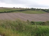
The parish includes gault and greensand
north-west of the road, and lower, middle and upper chalk
zones ascending the slope south-eastwards on to the high plain. Across the parish run The Ridgeway
along the scarp, the railway north of the greensand ridge, and the former turnpike road
in between. This forms the village street, where it is bordered on the west side by a small brook. Villagers cherish the brook, and have bridges across it to their cottages, and who have portrayed it on their village signs as a major river. The street is in a hollow, so that gardens on the east side rise very steeply and have been terraced up the slope. Paths and lanes lead off the street to ‘the Clays’ on the east and ‘the Sands’ on the west. The main streets in the village are Oak Lane, Haywards Place, High Street, White Street, the Clay, Kings Road and Vicarage Lane.
is derived from the Old English for "the more easterly farm". The modern parish was formerly part of Market Lavington
and would have been named from a farm that was to the east of the main settlement. In 1348 the name is recorded as Easton juxta Stepellavynton. Steeple Lavington was the early name for Market Lavington and the easterly farm was next to it.
 Easterton lies between the parishes of Urchfont
and Market Lavington. The village has three concentrations of buildings: around Easterton Manor House
and the Royal Oak (locally known simply as the Oak and said to be haunted by a miserable old ghost called the body warmer); near the Church of England parish church
, and at Eastcott along a secondary road (B3098) and interspersed with modern housing. Some older houses were lost as a result of road widening after the Second World War
and subsequently.
Easterton's parish boundaries were established in 1934. It is made up of the tithing of Easterton (comprising two manors
), formerly part of Market Lavington, and the tithing of Eastcott, which was formerly in Urchfont
. A map of 1773 suggests that there were then more buildings at Eastcott and between Eastcott and Easterton than at present, and therefore that the settlements have declined. The survival of timber-framed houses in separate groups in an area where from the 18th century brick buildings have predominated is consistent with such a decline. The origin of the name Eastcott, ‘the eastern cottage(s),’ which lay at the extreme western edge of Urchfont parish, cannot be easily explained.
 Market gardening
and fruit growing by smallholders on the fertile soils of the greensand became important as the traditional sheep and corn husbandry on the chalk (‘the Clays’) declined following enclosures
before 1800. Samuel Moore’s jam factory was a legacy of the fruit fields. It began in a small way early in thetwentieth century after an earlier venture had closed, and became a major employer in the area, with 100 staff in 1972. An extension was opened in 1985, but the whole enterprise closed during the 1990s, and visitors to the village are no longer greeted by the all-pervading aroma of warm strawberry jam. There used to be two small convenience stores, MacBeth's and Sainsbury's, but these have now closed. The nearest primary school is in the neighbouring parish of Market Lavington.
The rich soils may have been exploited many centuries before the surviving evidence of settlement, but Easterton, unusually among plain-edge villages, is the site of a Roman villa
estate, known from stray archaeological finds in the area of Kestrels in Oak Lane, west of the village. This may be linked with a mid 4th century Roman coin
hoard
, discovered in an urn during the Victorian era
and dispersed, although some coins passed to Devizes
Museum. Another possible Roman
site, deduced from place-name evidence, may lie at Wickham Green on the boundary with Urchfont some 2 km north of Kestrels.
 Easterton was made an ecclesiastical parish in 1874, and its small brick-built church was opened shortly afterwards. Other Victorian arrivals in the village were a Methodist chapel, built in 1868 and converted to a private house in 1985; and a school – this was opened in 1867, replaced in 1875, closed in 1971 and demolished in 1973.
Two lost buildings are of note. Eastcott had a chapel-of-ease from before 1309 until the Dissolution of the Monasteries
in 1548. Its exact site is unknown, but a field north of the road was known as Chapel Field in the 19th century. Wroughton’s Folly was a mansion built near Crookwood, close to the Urchfont and Potterne
parish boundaries, and was known variously as Folly House, Castle House and Maggot Castle (here, as elsewhere, the unflattering name is probably a corruption of ‘Margaret’). It was built and enlarged by two members of the Wroughton family, Francis and Seymour, between about 1730 and 1780. After Seymour’s accidental death in 1789 the house was left unoccupied and became a ruin. Its foundations, visible in the 19th century, have now entirely disappeared. Seymour’s ghost remains (according to local legend) recreating along his vanished driveway the furious carriage ride which ended in his death.
results for Easterton and Wiltshire:
unitary authority
, which is responsible for almost all significant local government functions.
Wiltshire
Wiltshire is a ceremonial county in South West England. It is landlocked and borders the counties of Dorset, Somerset, Hampshire, Gloucestershire, Oxfordshire and Berkshire. It contains the unitary authority of Swindon and covers...
, England
England
England is a country that is part of the United Kingdom. It shares land borders with Scotland to the north and Wales to the west; the Irish Sea is to the north west, the Celtic Sea to the south west, with the North Sea to the east and the English Channel to the south separating it from continental...
. The parish also includes the smaller settlement of Eastcott.
Geography
Easterton lies at the northern edge of Salisbury PlainSalisbury Plain
Salisbury Plain is a chalk plateau in central southern England covering . It is part of the Southern England Chalk Formation and largely lies within the county of Wiltshire, with a little in Hampshire. The plain is famous for its rich archaeology, including Stonehenge, one of England's best known...
.
The parish includes gault and greensand
Greensand
Greensand or Green sand is either a sand or sandstone, which has a greenish color. This term is specifically applied to shallow marine sediment, that contains noticeable quantities of rounded greenish grains. These grains are called glauconies and consist of a mixture of mixed-layer clay...
north-west of the road, and lower, middle and upper chalk
Chalk
Chalk is a soft, white, porous sedimentary rock, a form of limestone composed of the mineral calcite. Calcite is calcium carbonate or CaCO3. It forms under reasonably deep marine conditions from the gradual accumulation of minute calcite plates shed from micro-organisms called coccolithophores....
zones ascending the slope south-eastwards on to the high plain. Across the parish run The Ridgeway
The Ridgeway
thumb|right|thumb|The ancient tree-lined path winds over the downs countrysideThe Ridgeway is a ridgeway or ancient trackway described as Britain's oldest road...
along the scarp, the railway north of the greensand ridge, and the former turnpike road
Toll road
A toll road is a privately or publicly built road for which a driver pays a toll for use. Structures for which tolls are charged include toll bridges and toll tunnels. Non-toll roads are financed using other sources of revenue, most typically fuel tax or general tax funds...
in between. This forms the village street, where it is bordered on the west side by a small brook. Villagers cherish the brook, and have bridges across it to their cottages, and who have portrayed it on their village signs as a major river. The street is in a hollow, so that gardens on the east side rise very steeply and have been terraced up the slope. Paths and lanes lead off the street to ‘the Clays’ on the east and ‘the Sands’ on the west. The main streets in the village are Oak Lane, Haywards Place, High Street, White Street, the Clay, Kings Road and Vicarage Lane.
History
Easterton's toponymToponymy
Toponymy is the scientific study of place names , their origins, meanings, use and typology. The word "toponymy" is derived from the Greek words tópos and ónoma . Toponymy is itself a branch of onomastics, the study of names of all kinds...
is derived from the Old English for "the more easterly farm". The modern parish was formerly part of Market Lavington
Market Lavington
Market Lavington is a large village with a population of about 2,300 on the northern edge of Salisbury Plain in Wiltshire, England, near the market town of Devizes.-Status:...
and would have been named from a farm that was to the east of the main settlement. In 1348 the name is recorded as Easton juxta Stepellavynton. Steeple Lavington was the early name for Market Lavington and the easterly farm was next to it.
Urchfont
Urchfont is a small, rural village to the north of Salisbury Plain in Wiltshire, England, about seven miles from the market town of Devizes. The civil parish includes the hamlets of Wedhampton and Lydeway...
and Market Lavington. The village has three concentrations of buildings: around Easterton Manor House
Manor house
A manor house is a country house that historically formed the administrative centre of a manor, the lowest unit of territorial organisation in the feudal system in Europe. The term is applied to country houses that belonged to the gentry and other grand stately homes...
and the Royal Oak (locally known simply as the Oak and said to be haunted by a miserable old ghost called the body warmer); near the Church of England parish church
Church of England parish church
A parish church in the Church of England is the church which acts as the religious centre for the people within the smallest and most basic Church of England administrative region, known as a parish.-Parishes in England:...
, and at Eastcott along a secondary road (B3098) and interspersed with modern housing. Some older houses were lost as a result of road widening after the Second World War
World War II
World War II, or the Second World War , was a global conflict lasting from 1939 to 1945, involving most of the world's nations—including all of the great powers—eventually forming two opposing military alliances: the Allies and the Axis...
and subsequently.
Easterton's parish boundaries were established in 1934. It is made up of the tithing of Easterton (comprising two manors
Manorialism
Manorialism, an essential element of feudal society, was the organizing principle of rural economy that originated in the villa system of the Late Roman Empire, was widely practiced in medieval western and parts of central Europe, and was slowly replaced by the advent of a money-based market...
), formerly part of Market Lavington, and the tithing of Eastcott, which was formerly in Urchfont
Urchfont
Urchfont is a small, rural village to the north of Salisbury Plain in Wiltshire, England, about seven miles from the market town of Devizes. The civil parish includes the hamlets of Wedhampton and Lydeway...
. A map of 1773 suggests that there were then more buildings at Eastcott and between Eastcott and Easterton than at present, and therefore that the settlements have declined. The survival of timber-framed houses in separate groups in an area where from the 18th century brick buildings have predominated is consistent with such a decline. The origin of the name Eastcott, ‘the eastern cottage(s),’ which lay at the extreme western edge of Urchfont parish, cannot be easily explained.
Market gardening
A market garden is the relatively small-scale production of fruits, vegetables and flowers as cash crops, frequently sold directly to consumers and restaurants. It is distinguishable from other types of farming by the diversity of crops grown on a small area of land, typically, from under one acre ...
and fruit growing by smallholders on the fertile soils of the greensand became important as the traditional sheep and corn husbandry on the chalk (‘the Clays’) declined following enclosures
Enclosure
Enclosure or inclosure is the process which ends traditional rights such as mowing meadows for hay, or grazing livestock on common land. Once enclosed, these uses of the land become restricted to the owner, and it ceases to be common land. In England and Wales the term is also used for the...
before 1800. Samuel Moore’s jam factory was a legacy of the fruit fields. It began in a small way early in thetwentieth century after an earlier venture had closed, and became a major employer in the area, with 100 staff in 1972. An extension was opened in 1985, but the whole enterprise closed during the 1990s, and visitors to the village are no longer greeted by the all-pervading aroma of warm strawberry jam. There used to be two small convenience stores, MacBeth's and Sainsbury's, but these have now closed. The nearest primary school is in the neighbouring parish of Market Lavington.
The rich soils may have been exploited many centuries before the surviving evidence of settlement, but Easterton, unusually among plain-edge villages, is the site of a Roman villa
Roman villa
A Roman villa is a villa that was built or lived in during the Roman republic and the Roman Empire. A villa was originally a Roman country house built for the upper class...
estate, known from stray archaeological finds in the area of Kestrels in Oak Lane, west of the village. This may be linked with a mid 4th century Roman coin
Roman currency
The Roman currency during most of the Roman Republic and the western half of the Roman Empire consisted of coins including the aureus , the denarius , the sestertius , the dupondius , and the as...
hoard
Hoard
In archaeology, a hoard is a collection of valuable objects or artifacts, sometimes purposely buried in the ground. This would usually be with the intention of later recovery by the hoarder; hoarders sometimes died before retrieving the hoard, and these surviving hoards may be uncovered by...
, discovered in an urn during the Victorian era
Victorian era
The Victorian era of British history was the period of Queen Victoria's reign from 20 June 1837 until her death on 22 January 1901. It was a long period of peace, prosperity, refined sensibilities and national self-confidence...
and dispersed, although some coins passed to Devizes
Devizes
Devizes is a market town and civil parish in Wiltshire, England. The town is about southeast of Chippenham and about east of Trowbridge.Devizes serves as a centre for banks, solicitors and shops, with a large open market place where a market is held once a week...
Museum. Another possible Roman
Roman Britain
Roman Britain was the part of the island of Great Britain controlled by the Roman Empire from AD 43 until ca. AD 410.The Romans referred to the imperial province as Britannia, which eventually comprised all of the island of Great Britain south of the fluid frontier with Caledonia...
site, deduced from place-name evidence, may lie at Wickham Green on the boundary with Urchfont some 2 km north of Kestrels.
Two lost buildings are of note. Eastcott had a chapel-of-ease from before 1309 until the Dissolution of the Monasteries
Dissolution of the Monasteries
The Dissolution of the Monasteries, sometimes referred to as the Suppression of the Monasteries, was the set of administrative and legal processes between 1536 and 1541 by which Henry VIII disbanded monasteries, priories, convents and friaries in England, Wales and Ireland; appropriated their...
in 1548. Its exact site is unknown, but a field north of the road was known as Chapel Field in the 19th century. Wroughton’s Folly was a mansion built near Crookwood, close to the Urchfont and Potterne
Potterne
Potterne is a village in the English county of Wiltshire. The civil parish of Potterne includes the hamlet of Potterne Wick. In the census of 2001, the village had a population of 1,570. It is located slightly to the south of Devizes and lies on the A360 which passes from Devizes to Salisbury...
parish boundaries, and was known variously as Folly House, Castle House and Maggot Castle (here, as elsewhere, the unflattering name is probably a corruption of ‘Margaret’). It was built and enlarged by two members of the Wroughton family, Francis and Seymour, between about 1730 and 1780. After Seymour’s accidental death in 1789 the house was left unoccupied and became a ruin. Its foundations, visible in the 19th century, have now entirely disappeared. Seymour’s ghost remains (according to local legend) recreating along his vanished driveway the furious carriage ride which ended in his death.
Population
These are the censusCensus
A census is the procedure of systematically acquiring and recording information about the members of a given population. It is a regularly occurring and official count of a particular population. The term is used mostly in connection with national population and housing censuses; other common...
results for Easterton and Wiltshire:
| No. | Year | Easterton | Wiltshire |
| 1 | 1801 | 320 | 185,107 |
| 2 | 1811 | 364 | 193,828 |
| 3 | 1821 | 377 | 222,157 |
| 4 | 1831 | 417 | 240,156 |
| 5 | 1841 | 495 | 258,733 |
| 6 | 1851 | 532 | 254,221 |
| 7 | 1861 | 481 | 249,311 |
| 8 | 1871 | 470 | 257,177 |
| 9 | 1881 | 384 | 258,965 |
| 10 | 1891 | 363 | 264,997 |
| 11 | 1901 | 370 | 271,394 |
| 12 | 1911 | 323 | 286,822 |
| 13 | 1921 | 315 | 292,208 |
| 14 | 1931 | 301 | 303,373 |
| 15 | 1951 | 427 | 386,692 |
| 16 | 1961 | 472 | 422,950 |
| 17 | 1971 | 472 | 486,747 |
| 18 | 1981 | 537 | 518,545 |
| 19 | 1991 | 591 | 564,471 |
| 20 | 2001 | 583 | 613,024 |
Local government
Easterton is a civil parish with an elected parish council. It is in the area of Wiltshire CouncilWiltshire Council
Wiltshire Council is the unitary authority for most of the county of Wiltshire, in the West of England, the successor authority to Wiltshire County Council and to four districts—Kennet, North Wiltshire, Salisbury, and West Wiltshire—all of which had been created in 1973 and were...
unitary authority
Unitary authority
A unitary authority is a type of local authority that has a single tier and is responsible for all local government functions within its area or performs additional functions which elsewhere in the relevant country are usually performed by national government or a higher level of sub-national...
, which is responsible for almost all significant local government functions.
External links
- Wiltshire County Council Website page on Easterton, retrieved 11:15 Oct 14, 2004 (UTC)