
East Cowick
Encyclopedia
East Cowick is a village in the East Riding of Yorkshire
, England
. It is situated approximately 1.5 miles (2.4 km) east of the town of Snaith
. It lies on the A1041 road and just north of the M62 motorway
.
It forms part of the civil parish of Snaith and Cowick
.
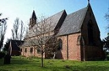
 The parish church of Holy Trinity was built by Charles Ward from Lincoln between 1853 and 1854, to a design by William Butterfield. The work was commissioned by the seventh Viscount Downe, William Henry Dawnay, and the west end is thought to be modelled on the church at Lindisfarne
(Holy Island) in Northumberland
. It is now a Grade II listed building. Dawnay's commission also included the vicarage and the Church of England
primary school, together with its schoolhouse, all of which are Grade II listed. Similar clusters of buildings were erected at Hensall
and Pollington
.
To the west of the village is the late 17th-century Grade I listed Cowick Hall, the former seat of the Viscounts Downe
which is now the headquarters of Croda International
. It was built between 1660 and 1690 for Sir John Dawnay, the first Viscount and James Paine altered it for the third Viscount between 1752 and 1760. The fifth Viscount made two further sets of changes in the 1790s and between 1804 and 1811, and the last major alterations were between 1869 and 1880 for Henry and Benjamin Shaw. Recent changes have been more minor. Nikolaus Pevsner, who catalogued the buildings of England, believed that the main fronts of Cowick Hall were among the most accomplished 17th-century country house designs in the land.
diverted the River Don northwards, to join the River Aire
. The work was part of the drainage of Hatfield Chase
, and the river skirted the eastern edge of the village, to join the Aire at Turnbridge. A "Great Sluice" was constructed where the rivers joined, which included a navigable lock. Following flooding of the villages bordering the new route, a 5 miles (8 km) channel was constructed from Newbridge near Thorne eastwards to Goole, where water levels in the River Ouse
were between 5 and 10 ft (1.5 and 3 m) lower than at Turnbridge. The channel was called the Dutch River, and was not intended to be navigable, so boats continued to use the lock at Turnbridge, until the sluice at Goole was swept away by floods in 1688. Boats started to use the Dutch River, and the channel through East Cowick gradually silted up. The bridge is now Grade II listed, and the parish boundary follows the course of the Don from the road to the Aire.
East Riding of Yorkshire
The East Riding of Yorkshire, or simply East Yorkshire, is a local government district with unitary authority status, and a ceremonial county of England. For ceremonial purposes the county also includes the city of Kingston upon Hull, which is a separate unitary authority...
, England
England
England is a country that is part of the United Kingdom. It shares land borders with Scotland to the north and Wales to the west; the Irish Sea is to the north west, the Celtic Sea to the south west, with the North Sea to the east and the English Channel to the south separating it from continental...
. It is situated approximately 1.5 miles (2.4 km) east of the town of Snaith
Snaith
Snaith is a town in the East Riding of Yorkshire local government area of England. It is situated approximately west of Goole on the A1041 road at its junction with the A645 road...
. It lies on the A1041 road and just north of the M62 motorway
M62 motorway
The M62 motorway is a west–east trans-Pennine motorway in Northern England, connecting the cities of Liverpool and Hull via Manchester and Leeds. The road also forms part of the unsigned Euroroutes E20 and E22...
.
It forms part of the civil parish of Snaith and Cowick
Snaith and Cowick
Snaith and Cowick is a civil parish in the East Riding of Yorkshire, England. It is situated approximately west of the town of Goole and covering an area of .The civil parish is formed by the town of Snaith and the villages of East Cowick and West Cowick....
.
Buildings
Lindisfarne
Lindisfarne is a tidal island off the north-east coast of England. It is also known as Holy Island and constitutes a civil parish in Northumberland...
(Holy Island) in Northumberland
Northumberland
Northumberland is the northernmost ceremonial county and a unitary district in North East England. For Eurostat purposes Northumberland is a NUTS 3 region and is one of three boroughs or unitary districts that comprise the "Northumberland and Tyne and Wear" NUTS 2 region...
. It is now a Grade II listed building. Dawnay's commission also included the vicarage and the Church of England
Church of England
The Church of England is the officially established Christian church in England and the Mother Church of the worldwide Anglican Communion. The church considers itself within the tradition of Western Christianity and dates its formal establishment principally to the mission to England by St...
primary school, together with its schoolhouse, all of which are Grade II listed. Similar clusters of buildings were erected at Hensall
Hensall, North Yorkshire
Hensall is a village and civil parish in the English county of North Yorkshire.For the purposes of local administration Hensall forms part of the district of Selby; before April 1974 it was part of Osgoldcross Rural District and the West Riding of Yorkshire....
and Pollington
Pollington
Pollington is a village and civil parish in the East Riding of Yorkshire, England. It is situated approximately south west of the town of Snaith and south of the M62 motorway...
.
To the west of the village is the late 17th-century Grade I listed Cowick Hall, the former seat of the Viscounts Downe
Viscount Downe
Viscount Downe is a title that has been created twice in the Peerage of Ireland. The first creation came in 1675 for William Ducie. However, the title became extinct on his death in 1679. The second creation came in 1680 for John Dawnay. He had earlier represented Yorkshire and Pontefract in the...
which is now the headquarters of Croda International
Croda International
Croda International plc is a chemicals company based at Snaith in the East Riding of Yorkshire, England. It is listed on the London Stock Exchange and is a constituent of the FTSE 250 Index.-History:...
. It was built between 1660 and 1690 for Sir John Dawnay, the first Viscount and James Paine altered it for the third Viscount between 1752 and 1760. The fifth Viscount made two further sets of changes in the 1790s and between 1804 and 1811, and the last major alterations were between 1869 and 1880 for Henry and Benjamin Shaw. Recent changes have been more minor. Nikolaus Pevsner, who catalogued the buildings of England, believed that the main fronts of Cowick Hall were among the most accomplished 17th-century country house designs in the land.
River Don
At the eastern border of the village, a three-arched bridge carries the A1041 road over a small stream. In 1628, the drainage engineer Cornelius VermuydenCornelius Vermuyden
Sir Cornelius Wasterdyk Vermuyden was a Dutch engineer who introduced Dutch reclamation methods to Britain, and made the first important attempts to drain The Fens of East Anglia.-Life:...
diverted the River Don northwards, to join the River Aire
River Aire
The River Aire is a major river in Yorkshire, England of length . Part of the river is canalised, and is known as the Aire and Calder Navigation....
. The work was part of the drainage of Hatfield Chase
Hatfield Chase
Hatfield Chase was a low-lying area in South Yorkshire, England which often flooded and is chiefly known from the Battle of Hatfield Chase in 633. It was a royal hunting ground until Charles I appointed the Dutch engineer Cornelius Vermuyden to drain it in 1626...
, and the river skirted the eastern edge of the village, to join the Aire at Turnbridge. A "Great Sluice" was constructed where the rivers joined, which included a navigable lock. Following flooding of the villages bordering the new route, a 5 miles (8 km) channel was constructed from Newbridge near Thorne eastwards to Goole, where water levels in the River Ouse
River Ouse, Yorkshire
The River Ouse is a river in North Yorkshire, England. The river is formed from the River Ure at Cuddy Shaw Reach near Linton-on-Ouse, about 6 miles downstream of the confluence of the River Swale with the River Ure...
were between 5 and 10 ft (1.5 and 3 m) lower than at Turnbridge. The channel was called the Dutch River, and was not intended to be navigable, so boats continued to use the lock at Turnbridge, until the sluice at Goole was swept away by floods in 1688. Boats started to use the Dutch River, and the channel through East Cowick gradually silted up. The bridge is now Grade II listed, and the parish boundary follows the course of the Don from the road to the Aire.