
River Ouse, Yorkshire
Encyclopedia

The River Ouse is a river in North Yorkshire
North Yorkshire
North Yorkshire is a non-metropolitan or shire county located in the Yorkshire and the Humber region of England, and a ceremonial county primarily in that region but partly in North East England. Created in 1974 by the Local Government Act 1972 it covers an area of , making it the largest...
, England. The river is formed from the River Ure
River Ure
The River Ure is a river in North Yorkshire, England, approximately long from its source to the point where it changes name to the River Ouse. It is the principal river of Wensleydale, which is the only one of the Dales now named after a village rather than its river...
at Cuddy Shaw Reach near Linton-on-Ouse
Linton-on-Ouse
Linton-on-Ouse is a village and civil parish in the Hambleton district of North Yorkshire, England, about eight miles north-west of York.Since 1937 Linton-on-Ouse has been home to an airforce base, RAF Linton-on-Ouse. Since 1957 the main role of the base has been training pilots.-External links:*...
, about 6 miles downstream of the confluence of the River Swale
River Swale
The River Swale is a river in Yorkshire, England and a major tributary of the River Ure, which itself becomes the River Ouse, emptying into the North Sea via the Humber Estuary....
with the River Ure. It then flows through the city of York
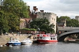
York
York is a walled city, situated at the confluence of the Rivers Ouse and Foss in North Yorkshire, England. The city has a rich heritage and has provided the backdrop to major political events throughout much of its two millennia of existence...
and the towns of Selby
Selby
Selby is a town and civil parish in North Yorkshire, England. Situated south of the city of York, along the course of the River Ouse, Selby is the largest and, with a population of 13,012, most populous settlement of the wider Selby local government district.Historically a part of the West Riding...
and Goole
Goole
Goole is a town, civil parish and port located approximately inland on the confluence of the rivers Don and Ouse in the East Riding of Yorkshire, England...
before joining with the River Trent
River Trent
The River Trent is one of the major rivers of England. Its source is in Staffordshire on the southern edge of Biddulph Moor. It flows through the Midlands until it joins the River Ouse at Trent Falls to form the Humber Estuary, which empties into the North Sea below Hull and Immingham.The Trent...
at Trent Falls
Trent Falls
Trent Falls is the name of the confluence of the River Ouse and the River Trent which forms the Humber in Yorkshire, England.Despite a training wall and a mini-lighthouse called 'Apex Light', navigation at Trent Falls is not simple...
, near the village of Faxfleet
Faxfleet
Faxfleet is a hamlet in the East Riding of Yorkshire, England. It is situated approximately east of Goole town centre. It is located at the start of the Humber, on the north bank, where the River Ouse and the River Trent meet....
, to form the Humber Estuary
Humber
The Humber is a large tidal estuary on the east coast of Northern England. It is formed at Trent Falls, Faxfleet, by the confluence of the tidal River Ouse and the tidal River Trent. From here to the North Sea, it forms part of the boundary between the East Riding of Yorkshire on the north bank...
. The length of the Ouse is about 84 km (52.2 mi) and the combined Ure/Ouse river is about 208 km (129.2 mi) making it the sixth longest river in the UK.
The Ouse's system of tributaries (which includes the Derwent
River Derwent, Yorkshire
The Derwent is a river in Yorkshire in the north of England. It is used for water abstraction, leisure and sporting activities and effluent disposal as well as being of significant importance as the site of several nature reserves...
, Aire
River Aire
The River Aire is a major river in Yorkshire, England of length . Part of the river is canalised, and is known as the Aire and Calder Navigation....
, Don, Wharfe
River Wharfe
The River Wharfe is a river in Yorkshire, England. For much of its length it is the county boundary between West Yorkshire and North Yorkshire. The name Wharfe is Celtic and means "twisting, winding".The valley of the River Wharfe is known as Wharfedale...
, Rother
River Rother, South Yorkshire
The River Rother is a river in the northern midlands of England, after which the town of Rotherham and the Rother Valley parliamentary constituency are named. It rises near Clay Cross in Derbyshire, and flows through the centre of Chesterfield, where it feeds the Chesterfield Canal...
, Nidd
River Nidd
The River Nidd is a tributary of the River Ouse in the English county of North Yorkshire. In its first few miles it is dammed three times to create Angram Reservoir, Scar House Reservoir and Gouthwaite Reservoir which attract around 150,000 visitors a year...
, Swale
River Swale
The River Swale is a river in Yorkshire, England and a major tributary of the River Ure, which itself becomes the River Ouse, emptying into the North Sea via the Humber Estuary....
, Ure
River Ure
The River Ure is a river in North Yorkshire, England, approximately long from its source to the point where it changes name to the River Ouse. It is the principal river of Wensleydale, which is the only one of the Dales now named after a village rather than its river...
, and Foss
River Foss
The River Foss is an improved river in North Yorkshire, England, and a tributary of the River Ouse. It rises in the Foss Crooks woods near Oulston reservoir close to the village of Yearsley and runs south through the Vale of York to the Ouse...
) drains a large upland area of Northern England, including much of the Yorkshire Dales and North York Moors.
The Ouse valley is a wide, flat plain; heavy rainfall in the river's catchment area
Drainage basin
A drainage basin is an extent or an area of land where surface water from rain and melting snow or ice converges to a single point, usually the exit of the basin, where the waters join another waterbody, such as a river, lake, reservoir, estuary, wetland, sea, or ocean...
can bring severe flooding to nearby settlements. In recent years both York
York
York is a walled city, situated at the confluence of the Rivers Ouse and Foss in North Yorkshire, England. The city has a rich heritage and has provided the backdrop to major political events throughout much of its two millennia of existence...
and Selby
Selby
Selby is a town and civil parish in North Yorkshire, England. Situated south of the city of York, along the course of the River Ouse, Selby is the largest and, with a population of 13,012, most populous settlement of the wider Selby local government district.Historically a part of the West Riding...
, and villages in between, have been very badly hit. The river has two weirs with locks, at Linton-on-Ouse
Linton-on-Ouse
Linton-on-Ouse is a village and civil parish in the Hambleton district of North Yorkshire, England, about eight miles north-west of York.Since 1937 Linton-on-Ouse has been home to an airforce base, RAF Linton-on-Ouse. Since 1957 the main role of the base has been training pilots.-External links:*...
and Naburn
Naburn
Naburn is a small village and civil parish in the unitary authority of the City of York in North Yorkshire, England. It lies on the eastern side of the River Ouse about south of York. According to the 2001 census the parish had a population of 470...
, so that boats of 45.7 m length and 4.6 m beam can reach York. The Ouse is tidal up to Naburn Locks.
In the 18th and 19th centuries there was considerable commercial traffic on the river, mainly from Selby, which then had a custom house, downstream, but after 1826 with the opening of the Aire and Calder Navigation
Aire and Calder Navigation
The Aire and Calder Navigation is a river and canal system of the River Aire and the River Calder in the metropolitan county of West Yorkshire, England. The first improvements to the rivers above Knottingley were completed in 1704 when the Aire was made navigable to Leeds and the Calder to...
most traffic was concentrated on the port of Goole
Goole
Goole is a town, civil parish and port located approximately inland on the confluence of the rivers Don and Ouse in the East Riding of Yorkshire, England...
, which continues until today, though the coal trade which formed its backbone has ceased.
Meaning
The word 'ouse' is a very common name for rivers in England - it derives from the Celtic word 'Usa', from *udso-, which simply means 'water'. 'River Ouse' therefore actually means 'River Water', etymologically.It has been suggested that the 'Ouse' was once all known as the 'Ure', but there seems to be no supporting evidence for this claim. In fact, more credence is given to the assertion that the name derives from the Old Celtic word for 'Ure', 'Isara', which over time evolved into 'Isure', 'Isurium', 'Isis' and finally the Saxon 'Ouse'. This linguistic evolution also goes some way to explaining how the little tributary 'Ouse Gill Beck' which enters at Linton-on-Ouse usurps the name of the much larger river 'Ure'.
Settlements
(From confluence of Swale and Ure)- Lower Dunsforth
- AldwarkAldwark, North YorkshireAldwark is a village and civil parish in the Hambleton district of North Yorkshire, England. It has a population of 116 , and is situated on the River Ouse about 14 miles from York. It has a wood called Aldwark Wood and a wood called Aldwark Bridge Wood.The main attractions for visitors to the...
- Linton-on-OuseLinton-on-OuseLinton-on-Ouse is a village and civil parish in the Hambleton district of North Yorkshire, England, about eight miles north-west of York.Since 1937 Linton-on-Ouse has been home to an airforce base, RAF Linton-on-Ouse. Since 1957 the main role of the base has been training pilots.-External links:*...
- Newton-on-OuseNewton-on-OuseNewton-on-Ouse is a village and civil parish in the Hambleton district of North Yorkshire, England, about north-west of York....
- Nun MonktonNun MonktonNun Monkton is a village and civil parish in the Harrogate district of North Yorkshire, England. It is situated north of York at the confluence of the rivers Ouse and Nidd. Cottages and houses are grouped around a village green of with a duck pond and a maypole...
- BeningbroughBeningbroughBeningbrough is a village and civil parish in the Hambleton district of North Yorkshire, England. The parish includes Beningbrough Park and Beningbrough Hall. According to the 2001 census it had a population of 55. The River Ouse forms the border of the parish with the Harrogate district and the...
- OvertonOverton, North YorkshireOverton is a small village and civil parish in the Hambleton district of North Yorkshire, England, about north-west of York....
- Nether PoppletonNether PoppletonNether Poppleton is a village and civil parish in the unitary authority of the City of York in North Yorkshire, England. It is situated by the West bank of the River Ouse adjacent to Upper Poppleton, and west of York close to the A59 road from York to Harrogate...
- YorkYorkYork is a walled city, situated at the confluence of the Rivers Ouse and Foss in North Yorkshire, England. The city has a rich heritage and has provided the backdrop to major political events throughout much of its two millennia of existence...
- South BankSouth Bank, YorkSouth Bank is an area to the south of the River Ouse in York. The area is dominated by the disused Terry's chocolate factory and the numerous streets of terraced housing that surround it. Terry's Chocolate Factory opened in 1926, where over the years it manufactured Terry's Chocolate Orange,...
- FulfordFulfordFulford is a historic village and civil parish on the outskirts of York, England. Situated to the south of the city, on the east bank of the River Ouse, it was the site of the 11th century Battle of Fulford...
- BishopthorpeBishopthorpeBishopthorpe is a village and civil parish three miles south of York in the City of York unitary authority and ceremonial county of North Yorkshire, England. It is close to the River Ouse, and has a population of 3,174. Prior to 1996 it was part of the Selby district...
- NaburnNaburnNaburn is a small village and civil parish in the unitary authority of the City of York in North Yorkshire, England. It lies on the eastern side of the River Ouse about south of York. According to the 2001 census the parish had a population of 470...
- Acaster MalbisAcaster MalbisAcaster Malbis is a village and civil parish in the unitary authority of the City of York, England. It is located on the River Ouse, almost 5 miles south of York...
- Acaster SelbyAcaster SelbyAcaster Selby is a village in the Selby district of North Yorkshire, England. It is about 6 miles south of York and nearby settlements include Stillingfleet and Appleton Roebuck....
- CawoodCawoodCawood is a large village and civil parish in the Selby district of North Yorkshire, England that is notable as the finding-place of the Cawood sword....
- KelfieldKelfield, North YorkshireKelfield is a small village and civil parish in the Selby district of North Yorkshire, England.It is situated on the northern bank of the River Ouse, equidistant between the villages of Riccall, Cawood and Stillingfleet, approximately 5 miles north west of Selby.The village no longer has a school,...
- RiccallRiccallRiccall is a village and civil parish situated in the Selby district of North Yorkshire, England, lying 3.5 miles north of Selby and 9 miles to the south of York. It is historically part of the East Riding of Yorkshire. According to the 2001 census the parish had a total population of...
- BarlbyBarlbyBarlby is a linear village in North Yorkshire, England. It lies to the north-east of the market town of Selby, and is bordered to the west by the River Ouse and to the east by the A19 Barlby bypass...
- SelbySelbySelby is a town and civil parish in North Yorkshire, England. Situated south of the city of York, along the course of the River Ouse, Selby is the largest and, with a population of 13,012, most populous settlement of the wider Selby local government district.Historically a part of the West Riding...
- HemingbroughHemingbroughHemingbrough is a small village and civil parish in the Selby district of North Yorkshire, England that is located approximately from Selby and from Howden on the A63....
- Barmby on the MarshBarmby on the MarshBarmby on the Marsh is a village and civil parish in the East Riding of Yorkshire, England. It is situated approximately west of the market town of Howden...
- BoothBooth, East Riding of YorkshireBooth is a hamlet near Goole, also known as Boothferry or Boothferry Bridge...
- HookHook, East Riding of YorkshireHook is a village and civil parish in the East Riding of Yorkshire, England. It is situated approximately north east of Goole town centre and lies on the west bank of the River Ouse.According to the 2001 UK census, Hook parish had a population of 1,141....
- SkeltonSkelton, East Riding of YorkshireSkelton is a hamlet in the East Riding of Yorkshire, England on the east bank of the River Ouse. It is situated about south east of Howden and north east of Goole although the road distance from the latter is about because of the lack of nearby road bridges....
- GooleGooleGoole is a town, civil parish and port located approximately inland on the confluence of the rivers Don and Ouse in the East Riding of Yorkshire, England...
- SwinefleetSwinefleetSwinefleet is a village and civil parish in the East Riding of Yorkshire, England. It is situated approximately south east of the town of Goole on the A161 road from Goole to Crowle...
- SaltmarsheSaltmarsheSaltmarshe is a hamlet in the East Riding of Yorkshire, England, it forms part of the civil parish of Laxton. It is situated on the north bank of the River Ouse, approximately east of Goole....
- ReednessReednessReedness is a village and civil parish in the East Riding of Yorkshire, England. It is situated approximately east of the town of Goole and lies on the south bank of the River Ouse....
- Little ReednessLittle ReednessLittle Reedness is a hamlet in the East Riding of Yorkshire, England. It is situated approximately east of the town of Goole and lies on the south bank of the River Ouse.It forms part of the civil parish of Reedness....
- WhitgiftWhitgift, East Riding of YorkshireWhitgift is a small linear hamlet in the East Riding of Yorkshire, England approximately east of Goole. It is located alongside the River Ouse and north of the A161 road between Goole and Scunthorpe. Ousefleet and Reedness are to the east and west respectively...
- BlacktoftBlacktoftBlacktoft is a village and civil parish in the East Riding of Yorkshire, England. It is situated on the north bank of the River Ouse, not far from where it flows into the River Trent and becomes the Humber...
- OusefleetOusefleetOusefleet is a small hamlet in the East Riding of Yorkshire, England approximately east of Goole. It is located just south of the River Ouse and north of the A161 road between Goole and Scunthorpe.It forms part of the civil parish of Twin Rivers....
- FaxfleetFaxfleetFaxfleet is a hamlet in the East Riding of Yorkshire, England. It is situated approximately east of Goole town centre. It is located at the start of the Humber, on the north bank, where the River Ouse and the River Trent meet....
(Joins Trent to form Humber)
See also
- Rivers of the United Kingdom
- Blacktoft Sands RSPB reserve