
Eartha
Encyclopedia
Eartha, the world's largest rotating and revolving globe
, is located within the headquarters of the DeLorme
mapping corporation in Yarmouth, Maine
. The globe weighs approximately 5,600 pounds (2,500 kg), and has a diameter of over 41 feet (12.5 m). This gives it a scale of 1:1,000,000, on which one inch represents 16 miles (25.7 km), one millimeter represents one kilometer. As with most globes, it's mounted at a 23.5 degree angle, the same axial tilt as the Earth itself; thus the equator
is diagonal to the floor. It uses a cantilever
mount with two motors, and simulates one day's revolution and rotation every hour, though it is possible for the motors to fully rotate the globe in as little as one minute.
The globe was completed on July 23, 1998, and it uses a composite database built from satellite imagery
, shaded relief, colored bathymetry
, and information about road networks
and urban areas. The database used to generate the surface images was approximately 140 gigabyte
s.
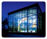
Eartha is contained in an atrium
with several glass walls that allow it to be seen from outside of the building; it is readily visible from U.S. Route 1
. At night, the globe is illuminated.
The atrium containing Eartha is open to the public during business hours. There is an adjacent gift shop that carries various DeLorme and geography related products. The mounting equipment is in a large pit below floor level and is visible to visitors, but the stairway down is chained off to prevent public access. There are two balconies that allow visitors to more easily view the higher parts of the globe. Some offices within the building also have views overlooking Eartha.
Eartha is constructed around a truss
structure which is called Omni-Span, and consists of over 6000 pieces of aluminum tubing. This is covered by a skin of 792 map panels, each covering 8 degrees of latitude
and 10 degrees of longitude
, and attached to the trusses with a custom-designed system of hidden bolts.
Eartha was originally designed to be 42 feet (12.8 m) in diameter. In 1999, surveyor
s hired by the Guinness Book of World Records measured the globe at 41 foot; while this is noted on the DeLorme web site (as of 2007-09-05), they also list the globe as 41.5 feet (12.6 m) in diameter. David DeLorme, CEO
of the DeLorme mapping company, is credited with the design. The previous record holder is the Globe of Peace
located in Apecchio
, Pesaro
, Italy
.
Globe
A globe is a three-dimensional scale model of Earth or other spheroid celestial body such as a planet, star, or moon...
, is located within the headquarters of the DeLorme
DeLorme
DeLorme is a major vendor of business-to-business and consumer mapping and GPS products and technologies. It is based in Yarmouth, Maine, United States....
mapping corporation in Yarmouth, Maine
Yarmouth, Maine
Yarmouth is a town in Cumberland County, Maine, United States, located approximately ten to fifteen miles north of Portland. Its population was 8,349 at the 2010 census....
. The globe weighs approximately 5,600 pounds (2,500 kg), and has a diameter of over 41 feet (12.5 m). This gives it a scale of 1:1,000,000, on which one inch represents 16 miles (25.7 km), one millimeter represents one kilometer. As with most globes, it's mounted at a 23.5 degree angle, the same axial tilt as the Earth itself; thus the equator
Equator
An equator is the intersection of a sphere's surface with the plane perpendicular to the sphere's axis of rotation and containing the sphere's center of mass....
is diagonal to the floor. It uses a cantilever
Cantilever
A cantilever is a beam anchored at only one end. The beam carries the load to the support where it is resisted by moment and shear stress. Cantilever construction allows for overhanging structures without external bracing. Cantilevers can also be constructed with trusses or slabs.This is in...
mount with two motors, and simulates one day's revolution and rotation every hour, though it is possible for the motors to fully rotate the globe in as little as one minute.
The globe was completed on July 23, 1998, and it uses a composite database built from satellite imagery
Satellite imagery
Satellite imagery consists of photographs of Earth or other planets made by means of artificial satellites.- History :The first images from space were taken on sub-orbital flights. The U.S-launched V-2 flight on October 24, 1946 took one image every 1.5 seconds...
, shaded relief, colored bathymetry
Bathymetry
Bathymetry is the study of underwater depth of lake or ocean floors. In other words, bathymetry is the underwater equivalent to hypsometry. The name comes from Greek βαθύς , "deep", and μέτρον , "measure"...
, and information about road networks
Highway
A highway is any public road. In American English, the term is common and almost always designates major roads. In British English, the term designates any road open to the public. Any interconnected set of highways can be variously referred to as a "highway system", a "highway network", or a...
and urban areas. The database used to generate the surface images was approximately 140 gigabyte
Gigabyte
The gigabyte is a multiple of the unit byte for digital information storage. The prefix giga means 109 in the International System of Units , therefore 1 gigabyte is...
s.
Eartha is contained in an atrium
Atrium (architecture)
In modern architecture, an atrium is a large open space, often several stories high and having a glazed roof and/or large windows, often situated within a larger multistory building and often located immediately beyond the main entrance doors...
with several glass walls that allow it to be seen from outside of the building; it is readily visible from U.S. Route 1
U.S. Route 1
U.S. Route 1 is a major north–south U.S. Highway that serves the East Coast of the United States. It runs 2,377 miles from Fort Kent, Maine at the Canadian border south to Key West, Florida. U.S. 1 generally parallels Interstate 95, though it is significantly farther west between...
. At night, the globe is illuminated.
The atrium containing Eartha is open to the public during business hours. There is an adjacent gift shop that carries various DeLorme and geography related products. The mounting equipment is in a large pit below floor level and is visible to visitors, but the stairway down is chained off to prevent public access. There are two balconies that allow visitors to more easily view the higher parts of the globe. Some offices within the building also have views overlooking Eartha.
Eartha is constructed around a truss
Truss
In architecture and structural engineering, a truss is a structure comprising one or more triangular units constructed with straight members whose ends are connected at joints referred to as nodes. External forces and reactions to those forces are considered to act only at the nodes and result in...
structure which is called Omni-Span, and consists of over 6000 pieces of aluminum tubing. This is covered by a skin of 792 map panels, each covering 8 degrees of latitude
Latitude
In geography, the latitude of a location on the Earth is the angular distance of that location south or north of the Equator. The latitude is an angle, and is usually measured in degrees . The equator has a latitude of 0°, the North pole has a latitude of 90° north , and the South pole has a...
and 10 degrees of longitude
Longitude
Longitude is a geographic coordinate that specifies the east-west position of a point on the Earth's surface. It is an angular measurement, usually expressed in degrees, minutes and seconds, and denoted by the Greek letter lambda ....
, and attached to the trusses with a custom-designed system of hidden bolts.
Eartha was originally designed to be 42 feet (12.8 m) in diameter. In 1999, surveyor
Surveying
See Also: Public Land Survey SystemSurveying or land surveying is the technique, profession, and science of accurately determining the terrestrial or three-dimensional position of points and the distances and angles between them...
s hired by the Guinness Book of World Records measured the globe at 41 foot; while this is noted on the DeLorme web site (as of 2007-09-05), they also list the globe as 41.5 feet (12.6 m) in diameter. David DeLorme, CEO
Chief executive officer
A chief executive officer , managing director , Executive Director for non-profit organizations, or chief executive is the highest-ranking corporate officer or administrator in charge of total management of an organization...
of the DeLorme mapping company, is credited with the design. The previous record holder is the Globe of Peace
Globe of Peace
The Globe of Peace is a very large globe located in Apecchio, Pesaro, Italy. It was the Guinness Book of World Records record holder for the world's largest rotating globe until 1999, when it was succeeded by Eartha...
located in Apecchio
Apecchio
Apecchio is a comune in the Province of Pesaro e Urbino in the Italian region Marche, located about 90 km west of Ancona and about 60 km southwest of Pesaro....
, Pesaro
Pesaro
Pesaro is a town and comune in the Italian region of the Marche, capital of the Pesaro e Urbino province, on the Adriatic. According to the 2007 census, its population was 92,206....
, Italy
Italy
Italy , officially the Italian Republic languages]] under the European Charter for Regional or Minority Languages. In each of these, Italy's official name is as follows:;;;;;;;;), is a unitary parliamentary republic in South-Central Europe. To the north it borders France, Switzerland, Austria and...
.