
Drygarn Fawr
Encyclopedia
Drygarn Fawr is a mountain in the county of Powys
, Wales
. It is one of the highest summits in Mid Wales
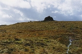
standing at 645 metres above sea level. Rising above the remote moorland
plateau
of the Cambrian Mountains
, the summit is topped by two distinctive, large cairn
s. The mountain has a gentle, grassy, conical shape with a few rocks near the summit. Nearby are the summits of Gorllwyn and Y Gamriw, both over 600m.
There are two paths to the summit which can offer impressive views. From Llannerch Yrfa, a bridleway winds up through forest
s in the Nant y Fedw valley before skirting the southern edge of the mountain.
An alternative route may be taken starting from Rhiwnant on the edge of the Caban Coch reservoir
, one of the Elan Valley Reservoirs
, and following the Nant Paradwys before turning off west towards the summit cairn. Both routes pass across wild moorland
and peat bogs and the path may become difficult to follow and impassable, particularly after heavy rain.
A compass
, map
and suitable clothing (the weather can be unpredictable) are recommended. However, it is very rewarding walk passing through the almost untouched desert of Wales
.
The views to the north include Pen y Garn
and Plynlimon
, to the east Rhos Fawr
and Gorllwyn
and the Brecon Beacons
to the south.
Powys
Powys is a local-government county and preserved county in Wales.-Geography:Powys covers the historic counties of Montgomeryshire and Radnorshire, most of Brecknockshire , and a small part of Denbighshire — an area of 5,179 km², making it the largest county in Wales by land area.It is...
, Wales
Wales
Wales is a country that is part of the United Kingdom and the island of Great Britain, bordered by England to its east and the Atlantic Ocean and Irish Sea to its west. It has a population of three million, and a total area of 20,779 km²...
. It is one of the highest summits in Mid Wales
Mid Wales
Mid Wales is the name given to the central region of Wales. The Mid Wales Regional Committee of the National Assembly for Wales covered the counties of Ceredigion and Powys and the area of Gwynedd that had previously been the district of Meirionydd. A similar definition is used by the BBC...
standing at 645 metres above sea level. Rising above the remote moorland
Moorland
Moorland or moor is a type of habitat, in the temperate grasslands, savannas, and shrublands biome, found in upland areas, characterised by low-growing vegetation on acidic soils and heavy fog...
plateau
Plateau
In geology and earth science, a plateau , also called a high plain or tableland, is an area of highland, usually consisting of relatively flat terrain. A highly eroded plateau is called a dissected plateau...
of the Cambrian Mountains
Cambrian Mountains
The Cambrian Mountains are a series of mountain ranges in Wales, reaching from, and including, the South Wales mountains of the Brecon Beacons, north Carmarthenshire and Ceredigion, the Black Mountains of eastern Wales, to Snowdonia in North Wales...
, the summit is topped by two distinctive, large cairn
Cairn
Cairn is a term used mainly in the English-speaking world for a man-made pile of stones. It comes from the or . Cairns are found all over the world in uplands, on moorland, on mountaintops, near waterways and on sea cliffs, and also in barren desert and tundra areas...
s. The mountain has a gentle, grassy, conical shape with a few rocks near the summit. Nearby are the summits of Gorllwyn and Y Gamriw, both over 600m.
There are two paths to the summit which can offer impressive views. From Llannerch Yrfa, a bridleway winds up through forest
Forest
A forest, also referred to as a wood or the woods, is an area with a high density of trees. As with cities, depending where you are in the world, what is considered a forest may vary significantly in size and have various classification according to how and what of the forest is composed...
s in the Nant y Fedw valley before skirting the southern edge of the mountain.
An alternative route may be taken starting from Rhiwnant on the edge of the Caban Coch reservoir
Reservoir
A reservoir , artificial lake or dam is used to store water.Reservoirs may be created in river valleys by the construction of a dam or may be built by excavation in the ground or by conventional construction techniques such as brickwork or cast concrete.The term reservoir may also be used to...
, one of the Elan Valley Reservoirs
Elan Valley Reservoirs
The Elan Valley Reservoirs are a chain of man-made lakes and reservoirs in the Elan Valley in Powys, Mid Wales , using the rivers Elan and Claerwen...
, and following the Nant Paradwys before turning off west towards the summit cairn. Both routes pass across wild moorland
Moorland
Moorland or moor is a type of habitat, in the temperate grasslands, savannas, and shrublands biome, found in upland areas, characterised by low-growing vegetation on acidic soils and heavy fog...
and peat bogs and the path may become difficult to follow and impassable, particularly after heavy rain.
A compass
Compass
A compass is a navigational instrument that shows directions in a frame of reference that is stationary relative to the surface of the earth. The frame of reference defines the four cardinal directions – north, south, east, and west. Intermediate directions are also defined...
, map
Map
A map is a visual representation of an area—a symbolic depiction highlighting relationships between elements of that space such as objects, regions, and themes....
and suitable clothing (the weather can be unpredictable) are recommended. However, it is very rewarding walk passing through the almost untouched desert of Wales
Desert of Wales
The Desert of Wales is a term coined to describe a large area in central Wales, so called because of its lack of roads and towns and its inaccessibility. The term was invented by English travel writers in the nineteenth century and its equivalent is not found in the Welsh language...
.
The views to the north include Pen y Garn
Pen y Garn
Pen y Garn is one of the highest mountains in Mid Wales standing at 610 metres above sea level. It is one of the Cambrian Mountains.It tops a 500–600 m high plateau situated on which is the controversial Cefn Coch wind farm. The summit has a very large shelter cairn hollowed out from the...
and Plynlimon
Plynlimon
Plynlimon is the highest point of the Cambrian Mountains in Wales, and the highest point in Mid Wales. It is a massif that dominates the countryside of northern Ceredigion....
, to the east Rhos Fawr
Rhos Fawr
Rhos Fawr or Great Rhos is a mountain in Mid Wales, and is the highest point on the Radnor Forest rock dome.The summit is located on a broad heathery plateau, which is separated from Black Mixen: the eastern plateau summit, by the cwm of Harvey Dingle...
and Gorllwyn
Gorllwyn
Gorllwyn is a subsidiary summit of Drygarn Fawr, located on a remote moorland plateau of the Cambrian Mountains. The summit is grassy and is surrounded by peat bog. There is a shelter cairn and a trig point....
and the Brecon Beacons
Brecon Beacons
The Brecon Beacons is a mountain range in South Wales. In a narrow sense, the name refers to the range of popular peaks south of Brecon, including South Wales' highest mountain, Pen y Fan, and which together form the central section of the Brecon Beacons National Park...
to the south.