
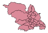
Districts of Sheffield
Encyclopedia
Sheffield
is a city
and metropolitan borough
in the north of England
. The neighbourhoods of Sheffield vary widely in size and history. Many of the neighbourhoods developed from villages or hamlets
that have become absorbed into Sheffield as the city has grown. For this reason, whilst the centre of most neighbourhoods is easy to define, the boundaries of many of the neighbourhoods are ambiguous. Neighbourhoods in Sheffield have little administrative role: for the purposes of local elections the city is subdivided into 28 electoral wards, and for the purposes of national elections the electoral wards are grouped into Parliamentary constituencies.
. Subsequently, in 1843 this Borough constituency formed the basis of the Municipal Borough
of Sheffield along with the parts of Upper Hallam and Ecclesall Bierlow omitted from the Borough constituency. Sheffield Municipal Borough was thereby formed from all six townships, and
would ultimately become the City of Sheffield in 1893. The Sheffield constituency was broken into five divisions in 1885: Attercliffe; Brightside; Central; Ecclesall
; and Hallam. Hillsborough and Park
constituencies were added in 1918 after the City extended its boundaries. The Central and Ecclesall constituencies were abolished in 1950 and two new constituencies, Heeley and Neepsend
, created. Neepsend was short-lived, being abolished by 1955, and Park was abolished, to be replaced by a revived Central constituency in 1983.
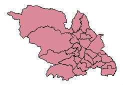
elections Sheffield is divided into 28 electoral wards. There was a Local Government ward boundary review that came into effect in 2004, evening out the number of voters per ward at 13,000 ± 10%. Parliamentary Constituencies are built out of whole numbers of local government wards within an administrative county.
The borough of Sheffield is currently (2010) covered by six parliamentary constituencies
. These are Sheffield Brightside and Hillsborough
, Sheffield Central, Sheffield Hallam, Sheffield Heeley, Sheffield South East
, and Penistone and Stocksbridge
, which also includes parts of the Metropolitan Borough of Barnsley
.
Arbourthorne
Arbourthorne, Gleadless, Gleadless Townend, Hollinsend, Newfield Green, Norfolk Park, and Ridgeway.
Central
Broomhall, Kelham Island
, Highfield, Little Sheffield, Sharrow
and the city centre
, Carbrook
, Darnall
, Tinsley
and part of Handsworth
.
Gleadless Valley
Gleadless Valley, Heeley
, Hemsworth, Herdings, Hurlfield, Lowfield and Meersbrook
.
, Malin Bridge
, Owlerton
, Wadsley
and Wisewood
.
Manor Castle
Manor, Manor Park, Park Hill and Wybourn.
Richmond, South Yorkshire
Four Lane Ends, Intake, Normanton Spring, Richmond and Woodthorpe.
.
Stannington
High Bradfield
, Low Bradfield
, Dungworth, Loxley
, Middlewood, Stannington, Strines, Woodland View and Worrall
.
Stocksbridge and Upper Don
Bolsterstone, Deepcar, Ewden, Midhopestones, Oughtibridge
, Stocksbridge and Wharncliffe Side.
Woodhouse
Handsworth
, Orgreave and Woodhouse.
Parish
There are three minor authorities within the Sheffield city boundaries: Stocksbridge
Town Council, Bradfield
Parish Council and Ecclesfield
Parish Council.
Sheffield
Sheffield is a city and metropolitan borough of South Yorkshire, England. Its name derives from the River Sheaf, which runs through the city. Historically a part of the West Riding of Yorkshire, and with some of its southern suburbs annexed from Derbyshire, the city has grown from its largely...
is a city
City status in the United Kingdom
City status in the United Kingdom is granted by the British monarch to a select group of communities. The holding of city status gives a settlement no special rights other than that of calling itself a "city". Nonetheless, this appellation carries its own prestige and, consequently, competitions...
and metropolitan borough
Metropolitan borough
A metropolitan borough is a type of local government district in England, and is a subdivision of a metropolitan county. Created in 1974 by the Local Government Act 1972, metropolitan boroughs are defined in English law as metropolitan districts, however all of them have been granted or regranted...
in the north of England
England
England is a country that is part of the United Kingdom. It shares land borders with Scotland to the north and Wales to the west; the Irish Sea is to the north west, the Celtic Sea to the south west, with the North Sea to the east and the English Channel to the south separating it from continental...
. The neighbourhoods of Sheffield vary widely in size and history. Many of the neighbourhoods developed from villages or hamlets
Hamlet (place)
A hamlet is usually a rural settlement which is too small to be considered a village, though sometimes the word is used for a different sort of community. Historically, when a hamlet became large enough to justify building a church, it was then classified as a village...
that have become absorbed into Sheffield as the city has grown. For this reason, whilst the centre of most neighbourhoods is easy to define, the boundaries of many of the neighbourhoods are ambiguous. Neighbourhoods in Sheffield have little administrative role: for the purposes of local elections the city is subdivided into 28 electoral wards, and for the purposes of national elections the electoral wards are grouped into Parliamentary constituencies.
Historical divisions
Prior to the breakup of the parish of Sheffield in 1848 the parish was divided into six townships: Attercliff-cum-Darnall; Brightside Bierlow; Ecclesall Bierlow; Nether Hallam; Sheffield township; and Upper Hallam. In 1832, with the exception of most of Upper Hallam and parts of Ecclesall Bierlow, these townships formed the basis of the new Borough constituency of SheffieldSheffield (UK Parliament constituency)
Sheffield was a borough constituency represented in the House of Commons of the Parliament of the United Kingdom 1832 to 1885. It elected two Members of Parliament by the bloc vote system of elections....
. Subsequently, in 1843 this Borough constituency formed the basis of the Municipal Borough
Municipal borough
Municipal boroughs were a type of local government district which existed in England and Wales between 1835 and 1974, in Northern Ireland from 1840 to 1973 and in the Republic of Ireland from 1840 to 2002...
of Sheffield along with the parts of Upper Hallam and Ecclesall Bierlow omitted from the Borough constituency. Sheffield Municipal Borough was thereby formed from all six townships, and
would ultimately become the City of Sheffield in 1893. The Sheffield constituency was broken into five divisions in 1885: Attercliffe; Brightside; Central; Ecclesall
Sheffield Ecclesall (UK Parliament constituency)
Sheffield Ecclesall was a Parliamentary constituency represented by a single Member of Parliament in the House of Commons from 1885 to 1950. It returned one Member of Parliament to the House of Commons of the Parliament of the United Kingdom, elected by the first past the post system.- Boundaries...
; and Hallam. Hillsborough and Park
Sheffield Park (UK Parliament constituency)
Sheffield Park was a Parliamentary constituency in the City of Sheffield, England. The constituency was created in 1918 and abolished in 1983. The area formerly covered by this constituency is now mostly in the Sheffield Central constituency....
constituencies were added in 1918 after the City extended its boundaries. The Central and Ecclesall constituencies were abolished in 1950 and two new constituencies, Heeley and Neepsend
Sheffield Neepsend (UK Parliament constituency)
Sheffield Neepsend was a short-lived Parliamentary constituency in the City of Sheffield, England. The constituency was created in 1950 and abolished in 1955, presumably due to its low number of electors - never exceeding 50,000...
, created. Neepsend was short-lived, being abolished by 1955, and Park was abolished, to be replaced by a revived Central constituency in 1983.
Present-day divisions
For the purposes of City CouncilSheffield City Council
Sheffield City Council is the city council for the metropolitan borough of Sheffield in South Yorkshire, England. It consists of 84 councillors, elected to represent 28 wards, each with three councillors...
elections Sheffield is divided into 28 electoral wards. There was a Local Government ward boundary review that came into effect in 2004, evening out the number of voters per ward at 13,000 ± 10%. Parliamentary Constituencies are built out of whole numbers of local government wards within an administrative county.
The borough of Sheffield is currently (2010) covered by six parliamentary constituencies
United Kingdom constituencies
In the United Kingdom , each of the electoral areas or divisions called constituencies elects one or more members to a parliament or assembly.Within the United Kingdom there are now five bodies with members elected by constituencies:...
. These are Sheffield Brightside and Hillsborough
Sheffield Brightside and Hillsborough (UK Parliament constituency)
Sheffield, Brightside and Hillsborough is a parliamentary constituency represented in the House of Commons of the Parliament of the United Kingdom...
, Sheffield Central, Sheffield Hallam, Sheffield Heeley, Sheffield South East
Sheffield South East (UK Parliament constituency)
Sheffield South East is a parliamentary constituency in the City of Sheffield, first used in the General Election 2010. It succeeded the existing Sheffield Attercliffe represented by the Labour MP Clive Betts following boundary changes in the South Yorkshire region recommended by The Boundary...
, and Penistone and Stocksbridge
Penistone and Stocksbridge (UK Parliament constituency)
Penistone and Stocksbridge is a parliamentary constituency represented in the House of Commons of the Parliament of the United Kingdom. It was contested for the first time at the 2010 general election, and returns one Member of Parliament elected by the first past the post system of election.-...
, which also includes parts of the Metropolitan Borough of Barnsley
Metropolitan Borough of Barnsley
The Metropolitan Borough of Barnsley is a metropolitan borough of the metropolitan county of South Yorkshire, England. Its main town is Barnsley....
.
ArbourthorneArbourthorneArbourthorne ward—which includes the districts of Arbourthorne, Gleadless, and Norfolk Park—is one of the 28 electoral wards in City of Sheffield, England. It is located in the southeastern part of the city and covers an area of . The population of this ward in 2001 was 17,500 people in...
Arbourthorne, Gleadless, Gleadless Townend, Hollinsend, Newfield Green, Norfolk Park, and Ridgeway.CentralSheffield Central wardCentral ward—which includes the districts of Broomhall, Highfield, Sharrow, and the city centre—is one of the 28 electoral wards in City of Sheffield, England. It covers the central area of the city, an area of 4.8 km2. The population of this ward in 2001 was 17,300 people in 7,300...
Broomhall, Kelham IslandKelham Island Quarter
Kelham Island is one of Sheffield's eleven designated Quarters. Formerly an industrial area, the island itself was created by the building of a goit, or mill race, fed from the River Don to serve the water wheels powering the workshops of the areas' industrial heyday...
, Highfield, Little Sheffield, Sharrow
Sharrow
For the village in North Yorkshire, see Sharow. For the shared lane roadway marking, see Shared lane marking.Sharrow is a district of Sheffield directly south west of Sheffield city centre....
and the city centre
Sheffield City Centre
Sheffield City Centre—often just referred to as town—is a district of the City of Sheffield, and part of the Sheffield Central ward. It includes the area that is within a radius of roughly of Sheffield Cathedral, and is encircled by the Inner Ring Road—a circular route started in the late 1960s...
Darnall
AttercliffeAttercliffe
Attercliffe is an industrial suburb of northeast Sheffield, England on the south bank of the River Don.-History:The name Attercliffe can be traced back as far as an entry in the Domesday book -Ateclive- meaning at the cliffe, a small escarpment that lay alongside the River Don...
, Carbrook
Carbrook, South Yorkshire
Carbrook is an industrial area of Sheffield, South Yorkshire, England to the north-east of Brightside. The suburb is named for the Carr Brook, which ran through the area until the late eighteenth century....
, Darnall
Darnall
Darnall ward—which includes the districts of Attercliffe, Carbrook, Darnall, Tinsley, and parts of Handsworth—is one of the 28 electoral wards in City of Sheffield, South Yorkshire, England. It is located in the eastern part of the city and covers an area of 17.4 km2. The...
, Tinsley
Tinsley, South Yorkshire
Tinsley is a suburb of northeastern part of Sheffield, South Yorkshire. Its name derives from the Old English Tingas-Leah, which means 'Field of Council'...
and part of Handsworth
Handsworth, South Yorkshire
Handsworth is a suburb of south eastern Sheffield, in South Yorkshire, England. Handsworth has a population of approximately 15,000. It covers an overall area of approximately...
.
Gleadless ValleyGleadless ValleyGleadless Valley ward—which includes the districts of Gleadless Valley , Heeley, Lowfield, and Meersbrook—is one of the 28 electoral wards in City of Sheffield, England. It is located in the southern part of the city and covers an area of 4.5 km2...
Gleadless Valley, HeeleyHeeley
Heeley is a former cluster of villages now a suburb in the south of the City of Sheffield, England. The village has existed at least since 1343, its name deriving from Heah Leah, High Lea then Hely, meaning a high, woodland clearing...
, Hemsworth, Herdings, Hurlfield, Lowfield and Meersbrook
Meersbrook
Meersbrook is a suburban district in the Gleadless Valley ward of Sheffield, England located to the south of Heeley. The name comes from the stream, the Meers Brook, a tributary of the River Sheaf which means 'boundary brook' and in ancient times this, along with the River Sheaf formed the...
.
Hillsborough
HillsboroughHillsborough, South Yorkshire
Hillsborough is an electoral ward which includes the districts of Malin Bridge, Owlerton, Wadsley and Wisewood. It is one of the 28 electoral wards in City of Sheffield, England. It is located in the northwestern part of the city and covers an area of 4.6 km2...
, Malin Bridge
Malin Bridge
Malin Bridge is a suburb of the city of Sheffield, England. It is located at grid reference and stands 2½ miles north-west of the city centre where the rivers Loxley and Rivelin meet...
, Owlerton
Owlerton
Owlerton is a suburb of the city of Sheffield, it lies northwest of the city centre near the confluence of the River Don and River Loxley. Owlerton was formerly a small rural settlement with its origins in the Early Middle Ages, it became part of Sheffield in the early 1900s as the city expanded...
, Wadsley
Wadsley
Wadsley is a suburb of the City of Sheffield in South Yorkshire, England. It stands five km NW of the city centre at an approximate grid reference of...
and Wisewood
Wisewood
Wisewood is a suburb of the city of Sheffield in South Yorkshire, England and situated 4.5 km north-west of the city centre. It is a residential suburb consisting almost exclusively of council housing, some of which has been bought by tenants under the right to buy scheme...
.
Manor CastleManor, South YorkshireManor Castle ward—which includes the districts of Claywood, Manor, Manor Park, Park Hill, and Wybourn—is one of the 28 electoral wards in City of Sheffield, England. It is located in the eastern part of the city and covers an area of 5.4 km2. The population of this ward in 2001 was...
Manor, Manor Park, Park Hill and Wybourn.Richmond, South YorkshireRichmond, South YorkshireRichmond ward—which includes the districts of Four Lane Ends, Intake, Richmond, and Woodthorpe—is one of the 28 electoral wards in City of Sheffield, England. It is located in the southern part of the city and covers an area of 4.5 km2. The population of this ward in 2001 was...
Four Lane Ends, Intake, Normanton Spring, Richmond and Woodthorpe.Southey
Birley Carr, Foxhill, Parson Cross, Southey and Wadsley BridgeWadsley Bridge
Wadsley Bridge is a suburb of Sheffield 3 mi northwest of the city centre. The area is a mixture of residential housing and small industrial and commercial premises.-Etymology:...
.
StanningtonStanningtonStannington Ward—which includes the districts of Loxley, Stannington, and Worrall, and also the small villages of Dungworth, High Bradfield, and Low Bradfield—is one of the 28 electoral wards in City of Sheffield, England. It is located in the western part of the city and covers an area...
High BradfieldHigh Bradfield
High Bradfield is a small village located north west of the centre of Sheffield in South Yorkshire, England at Grid Reference and within the city's boundaries...
, Low Bradfield
Low Bradfield
Low Bradfield is a village within the in South Yorkshire, England. It is situated within the boundary of the city of Sheffield in the upper part of the Loxley Valley, 6¼ miles west-northwest of the city centre and just inside the northeast boundary of the Peak District National Park...
, Dungworth, Loxley
Loxley, South Yorkshire
Loxley is a village and a suburb of the city of Sheffield. It is a long linear community which stretches by the side of the River Loxley and along the B6077 for almost four kilometres. Loxley extends from its borders with the suburbs of Malin Bridge and Wisewood westward to the hamlet of Stacey...
, Middlewood, Stannington, Strines, Woodland View and Worrall
Worrall
Worrall is a small rural village within the boundary of the City of Sheffield. It stands in an elevated position at a height of approximately 230 metres and is 6.5 km north west of the city centre. The village has an area of 233 hectares and a population of 1,306 in 2006...
.
Stocksbridge and Upper DonStocksbridge and Upper DonStocksbridge and Upper Don ward—which includes the districts of Deepcar, Oughtibridge, Stocksbridge, and Wharncliffe Side, and the villages of Bolsterstone, Ewden, and Midhopestones—is one of the 28 electoral wards in the City of Sheffield, South Yorkshire, England...
Bolsterstone, Deepcar, Ewden, Midhopestones, OughtibridgeOughtibridge
Oughtibridge is a residential village on the northern outskirts of Sheffield within the bounds of Bradfield Parish Council. The village stands northwest of the city centre in the valley of the River Don...
, Stocksbridge and Wharncliffe Side.
WoodhouseWoodhouse, South YorkshireWoodhouse ward—which includes the district of Woodhouse and most of Handsworth—is one of the 28 electoral wards in City of Sheffield, England. It is located in the southeastern part of the city and covers an area of 7 km2. The population of this ward in 2001 was 17,900 people in...
HandsworthHandsworth, South Yorkshire
Handsworth is a suburb of south eastern Sheffield, in South Yorkshire, England. Handsworth has a population of approximately 15,000. It covers an overall area of approximately...
, Orgreave and Woodhouse.
Area names that refer to wider areas encompassing many neighbourhoods
- Abbeydale
- Rivelin
- Lower Don ValleyLower Don ValleyThe Lower Don Valley, or historically the East End of Sheffield, is the mainly industrial north-east quarter of Sheffield, England. Based around the River Don it encompasses the areas of Attercliffe, Brightside, Darnall, Tinsley and Wincobank....
/East End - Upper Don Valley
ParishParishA parish is a territorial unit historically under the pastoral care and clerical jurisdiction of one parish priest, who might be assisted in his pastoral duties by a curate or curates - also priests but not the parish priest - from a more or less central parish church with its associated organization...
and Town Councils
There are three minor authorities within the Sheffield city boundaries: StocksbridgeStocksbridge
Stocksbridge is a small town and civil parish in the City of Sheffield, in South Yorkshire, England, with a population of 13,663. It lies just to the east of the Peak District....
Town Council, Bradfield
Bradfield, South Yorkshire
Bradfield is a village and civil parish in the City of Sheffield, in South Yorkshire, England. It is situated in the Peak District. Bradfield itself is divided into two settlements, High Bradfield atop a hill and Low Bradfield in the valley of the River Loxley.Bradfield is the largest parish in...
Parish Council and Ecclesfield
Ecclesfield
Ecclesfield is a suburb and civil parish in the City of Sheffield in South Yorkshire, England, about north of Sheffield City Centre. At the 2001 census the civil parish— which also includes the Sheffield suburbs of Chapeltown, Grenoside, High Green, and formerly Thorpe Hesley —had a population...
Parish Council.