

Kitikmeot Region, Northwest Territories
Encyclopedia
Northwest Territories
The Northwest Territories is a federal territory of Canada.Located in northern Canada, the territory borders Canada's two other territories, Yukon to the west and Nunavut to the east, and three provinces: British Columbia to the southwest, and Alberta and Saskatchewan to the south...
until division in April 1999 when most of the region became part of Nunavut
Nunavut
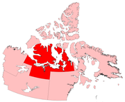
Nunavut is the largest and newest federal territory of Canada; it was separated officially from the Northwest Territories on April 1, 1999, via the Nunavut Act and the Nunavut Land Claims Agreement Act, though the actual boundaries had been established in 1993...
. It consisted of Victoria Island with the adjacent part of the mainland as far as the Boothia Peninsula
Boothia Peninsula
Boothia Peninsula is a large peninsula in Nunavut's northern Canadian Arctic, south of Somerset Island. The northern part, Murchison Promontory, is the northernmost point of mainland Canada, and thus North America....
, together with King William Island
King William Island
King William Island is an island in the Kitikmeot Region of Nunavut and forms part of the Canadian Arctic Archipelago. In area it is between and making it the 61st largest island in the world and Canada's 15th largest island...
and the southern portion of Prince of Wales Island
Prince of Wales Island, Nunavut
One of the larger members of the Canadian Arctic Archipelago, Prince of Wales Island is an Arctic island in Nunavut, Canada, lying between Victoria Island and Somerset Island and south of the Queen Elizabeth Islands....
. The regional seat was Cambridge Bay
Cambridge Bay, Nunavut
Cambridge Bay, named for Prince Adolphus, Duke of Cambridge, is a hamlet located in the Kitikmeot Region of Nunavut, Canada...
(pop. 1,351 - 1996).
Originally the entire region was part of the Fort Smith Region, Northwest Territories
Fort Smith Region, Northwest Territories
Fort Smith Region is one of Statistics Canada's two census divisions of the Northwest Territories, Canada. It contains more than 77 percent of the population and more than 54 percent of the land area of the Northwest Territories. Its main economic centre is the territorial capital of Yellowknife...
and was later called the "Central Arctic Region". For administrative purposes the region consisted of (all population figures 1996):
- Cambridge BayCambridge Bay, NunavutCambridge Bay, named for Prince Adolphus, Duke of Cambridge, is a hamlet located in the Kitikmeot Region of Nunavut, Canada...
(1,351) - CoppermineKugluktuk, NunavutKugluktuk is a hamlet located at the mouth of the Coppermine River in the Kitikmeot Region of Nunavut, Canada, on Coronation Gulf, southwest of Victoria Island...
(1,201), now Kugluktuk - Gjoa HavenGjoa Haven, NunavutGjoa Haven is a hamlet in Nunavut, above the Arctic Circle, located in the Kitikmeot Region, northeast of Yellowknife, Northwest Territories. It is the only settlement on King William Island...
(879) - Spence BayTaloyoak, NunavutTaloyoak or Talurjuaq is located on the Boothia Peninsula, Kitikmeot, in Canada's Nunavut Territory. The community is served only by air and by annual supply sealift. Taloyoak may mean "large blind", referring to a stone caribou blind or a screen used for caribou hunting...
(648), now Taloyoak - Pelly BayKugaaruk, Nunavut-Culture:The historical inhabitants were Arviligjuarmiut. Kugaaruk is a traditional "Central Inuit" community. Until 1968, the people followed a nomadic lifestyle. The population is approximately 97% Inuit and most people self-identify as Netsilik Inuit. The residents blend a land based lifestyle...
(496), now Kugaaruk - HolmanUlukhaktok, Northwest TerritoriesUlukhaktok is a small hamlet on the west coast of Victoria Island, in the Inuvik Region of the Northwest Territories, Canada. The 2006 census indicated a population of 398 of which 360 were Inuvialuit or Inuit along with 7.5% non-Aboriginal and 2.5% North American Indian...
(423) now Ulukhaktok - Bay ChimoUmingmaktok, NunavutThe community of Umingmaktok is located in Bathurst Inlet in the Kitikmeot Region of Canada's Nunavut Territory...
(51), now Umingmaktok - Bathurst InletBathurst Inlet, NunavutBathhurst Inlet, , is a small Inuit community located in Bathurst Inlet in the Kitikmeot Region of Canada's Nunavut Territory...
(18)
However, for NWT election purposes Holman was included in the Nunakput
Nunakput
Nunakput is a territorial electoral district for the Legislative Assembly of the Northwest Territories, Canada. The district consists of Paulatuk, Sachs Harbour, Tuktoyaktuk and Ulukhaktok.The current Member of the Legislative Assembly is Jackie Jacobson....
district unlike the rest of the Kitikmeot.
After division Holman remained with the Northwest Territories while the rest of region became Kitikmeot Region, Nunavut
Kitikmeot Region, Nunavut
Kitikmeot Region is an administrative region of Nunavut, Canada. It consists of the southern and eastern parts of Victoria Island with the adjacent part of the mainland as far as the Boothia Peninsula, together with King William Island and the southern portion of Prince of Wales Island...
.