

Districts of Jammu and Kashmir
Encyclopedia
India
India , officially the Republic of India , is a country in South Asia. It is the seventh-largest country by geographical area, the second-most populous country with over 1.2 billion people, and the most populous democracy in the world...
n state of Jammu and Kashmir
Jammu and Kashmir
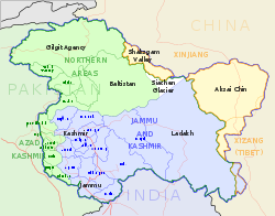
Jammu and Kashmir is the northernmost state of India. It is situated mostly in the Himalayan mountains. Jammu and Kashmir shares a border with the states of Himachal Pradesh and Punjab to the south and internationally with the People's Republic of China to the north and east and the...
consists of three divisions: Jammu, Kashmir Valley and Ladakh, and is further divided into 22 districts:
Jammu
Jammu
Jammu , also known as Duggar, is one of the three administrative divisions within Jammu and Kashmir, the northernmost state in India.Jammu city is the largest city in Jammu and the winter capital of Jammu and Kashmir...
region
- KathuaKathua districtKathua district is one of 22 administrative districts that comprise the state of Jammu and Kashmir in India. It is surrounded by Jammu to the northwest, the Doda and Udhampur districts to the north, the state of Himachal Pradesh to the east, Punjab to the south, and Pakistan's working boundary to...
- JammuJammu DistrictJammu District is a district in Jammu and Kashmir. Jammu is the winter capital of the state. The majority of the population of the district practise Hinduism; people of all religions, Muslims, Sikhs live in peace and harmony. Jammu is also known as city of temples with major attraction as Maa...
- Samba
- UdhampurUdhampur DistrictUdhampur is a district in Jammu and Kashmir. The town of Udhampur is the headquarters of this district.The 2001 census indicates the population of the district to be 743,509. There are 871 females for every 1000 males in the district. The overall literacy rate is 54.16%, with 66.43% for males and...
- ReasiReasi DistrictReasi is one of the oldest towns of the Jammu and Kashmir State. It was the seat of the erstwhile Bhimgarh State, said to have been established by Raja Bhim Dev somewhere in the 8th century. It remained an independent principality till 1822, when Maharaja Gulab Singh the then King of Jammu...
- RajouriRajouri DistrictRajouri is a district of Jammu province in the Indian-administered Kashmir. It is close to the control line and borders with Ponch to the north and Mirpur to the southwest, both of which are in Pakistan-administered Kashmir....
- Poonch
- DodaDoda DistrictArea11,691 km²Population525,000 Population density36/km2 Literacy18.5% Doda is a district of Jammu region in the state of Jammu and Kashmir, India...
- Ramban
- Kishtwar
Kashmir Valley region
- AnantnagAnantnag DistrictAnantnag is a district in the state of Jammu and Kashmir in north-western India. It is one of eight districts which make up the Kashmir Valley. The district headquarter is Anantnag...
- Kulgam
- PulwamaPulwama DistrictArea1,398 km²Population649,000 Population density464/km2 Literacy47.76% Pulwama is a district in Jammu and Kashmir, India.-Administration:Pulwama district has 3 tehsils:*Pampore Tehsil*Pulwama Tehsil...
- Shopian
- BudgamBudgam districtBudgam District is a district of the state of Jammu and Kashmir in India. It was formed in 1979.-Administration:Budgam district consists of 8 blocks: Beerwah, Nagam, Budgam, B.K.Pora, Khan Sahib, Khag, Narbal and Chadoora...
- SrinagarSrinagar DistrictFor other uses, see Srinagar .Area141 km2Population900,000 Population density6383/km2 Situated at the center of the Kashmir valley, Srinagar is the most populous district in the state of Jammu and Kashmir,Indian Administered Kashmir and is home to the summer capital of Jammu and Kashmir For...
- Ganderbal
- BandiporaBandipora DistrictBandipora district is one of the 22 districts in Jammu and Kashmir state in northern India. Bandipora town is the administrative headquarters of the district. This district was carved out from the erstwhile Baramulla district in 2007. The district is bounded by Kupwara district in the west,...
- Baramulla
- KupwaraKupwara DistrictKupwara District is located in Jammu and Kashmir, India.-Administration:Kupwara district has 3 tehsils: Handwara, Karnah and Kupwara.This district consists of 11 blocks: Sogam, Tangdar, Teetwal, Ramhal, Kupwara, Rajwal, Kralpora, Langate, Wavoora, Trehgam and Kalaroo...
Ladakh
Ladakh
Ladakh is a region of Jammu and Kashmir, the northernmost state of the Republic of India. It lies between the Kunlun mountain range in the north and the main Great Himalayas to the south, inhabited by people of Indo-Aryan and Tibetan descent...
region
- KargilKargil DistrictKargil is a district of Ladakh, Kashmir, India. Kargil lies near the Line of Control facing Pakistan-occupied Kashmir's Baltistan to the west, and Kashmir valley to the south. Zanskar is part of Kargil district along with Suru, Wakha and Dras valleys...
- LehLeh DistrictLeh is one of the two districts located in Ladakh, the other being the Kargil District to the west, in the state of Jammu and Kashmir, India. It is the second largest district in India in terms of area. It is bounded on the north by Ghanche District , a small border with Xinjiang, China, via the...
The Siachen Glacier
Siachen Glacier
The Siachen Glacier is located in the eastern Karakoram range in the Himalaya Mountains at about , just east of the Line of Control between India-Pakistan. India controls all of the Siachen Glacier itself, including all tributary glaciers. At long, it is the longest glacier in the Karakoram and...
, although under Indian military control, does not lie under the administration of the state of Jammu and Kashmir. Kishtwar, Ramban, Reasi, Samba, Bandipora, Ganderbal, Kulgam and Shopian are newly formed districts.