

Districts of Cologne
Encyclopedia
Since the last administrative reform in 1975, the City of Cologne
is made up of nine Stadtbezirke and 86 Stadtteile. Stadtbezirk
literally translates as city district
, which are further subdivided into Stadtteile (city parts). The Stadtteile of Cologne's old and new town (Alt- and Neustadt) further consist of quarters, known as "Veedel" in the Kölsch dialect.
City districts are differentiated of being links- or rechtsrheinisch – left or right of the Rhine, with the old town being left of the Rhine, as are 230,25 km² (56.8 percent of 405,14 km² within city limits), while 174,87 km² (43.2 percent) lie right of the Rhine. In regards to population, Cologne is the largest city in the state of North Rhine-Westphalia
and the fourth largest city in Germany.
, Cologne grew through numerous extensions and incorporation of surrounding municipalities. Since the construction of the Medieval wall in 1180, the area of the old imperial city
of Cologne has not changed for more than 600 years and was only extended over the old city walls in 1794, just short before the arrival of French troops and Cologne's incorporation into the First French Empire
.
After 1815, the Kingdom of Prussia
enforced the construction of fortifications which again hindered any growth for the city. Only with the acquisition of these fortifications in 1881, the city of Cologne had the possibility of a gradual territorial expansion. On 12. November 1883 a strip of territory from parts of the municipalities of Ehrenfeld, Kriel, Longerich, Müngersdorf and Rondorf was added to the city. At the time of the industrial revolution
, industrial enterprises already avoided the densely populated areas inside of the city limits and settled in the small towns outside the fortified area, while maintaining close economic links to the city of Cologne. More than half of the estates here were in the hands of citizens of Cologne or the same becoming residents in these areas.
Since 1886, the Cologne City Council
intensified negotiations with the surrounding communities, and on 1 April 1888 ended in a first major incorporation. Since then the city has expanded with major reorganizations in 1910, 1914, 1922 and 1975.
Source: Historical Archive of the City of Cologne
Cologne
Cologne is Germany's fourth-largest city , and is the largest city both in the Germany Federal State of North Rhine-Westphalia and within the Rhine-Ruhr Metropolitan Area, one of the major European metropolitan areas with more than ten million inhabitants.Cologne is located on both sides of the...
is made up of nine Stadtbezirke and 86 Stadtteile. Stadtbezirk
Stadtbezirk
A Stadtbezirk is a form of German city district, an administrative unit within a larger city. In Germany Stadtbezirke usually only exist in a metropolis with more than 150,000 inhabitants....
literally translates as city district
City district
City district is a type of administrative division of Pakistan and Croatia.It is also the English translation of German Stadtbezirk and Swedish Stadsdel.-See also:*City Districts of Pakistan...
, which are further subdivided into Stadtteile (city parts). The Stadtteile of Cologne's old and new town (Alt- and Neustadt) further consist of quarters, known as "Veedel" in the Kölsch dialect.
City districts are differentiated of being links- or rechtsrheinisch – left or right of the Rhine, with the old town being left of the Rhine, as are 230,25 km² (56.8 percent of 405,14 km² within city limits), while 174,87 km² (43.2 percent) lie right of the Rhine. In regards to population, Cologne is the largest city in the state of North Rhine-Westphalia
North Rhine-Westphalia
North Rhine-Westphalia is the most populous state of Germany, with four of the country's ten largest cities. The state was formed in 1946 as a merger of the northern Rhineland and Westphalia, both formerly part of Prussia. Its capital is Düsseldorf. The state is currently run by a coalition of the...
and the fourth largest city in Germany.
Districts
| Map | Coat | City district | City parts | Area | Population1 | Pop. density | District Councils | Town Hall |
|---|---|---|---|---|---|---|---|---|
 |
1st district Köln-Innenstadt | Altstadt-Nord, Altstadt-Süd, Deutz, Neustadt-Nord, Neustadt-Süd | 16.4 km² | 127.033 | 7.746/km² | Bezirksksamt Innenstadt Brückenstraße 19, D-50667 Köln |
||
 |
 |
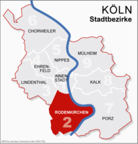
2nd district Köln-Rodenkirchen | Bayenthal Bayenthal Bayenthal is a small municipal part of Cologne, Germany and part of the district of Rodenkirchen. Bayenthal lies on the left bank of the river Rhine, between the district of Innenstadt to the North and Marienburg to the South. The borders to these are defined by the Southern Bridge and the... , Godorf, Hahnwald, Immendorf, Marienburg, Meschenich, Raderberg, Raderthal, Rodenkirchen, Rondorf, Sürth, Weiß, Zollstock |
54.6 km² | 100.936 | 1.850/km² | Bezirksamt Rodenkirchen Hauptstraße 85, D-50996 Köln |
|
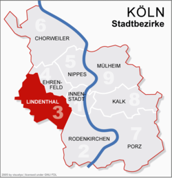 |
3rd district Köln-Lindenthal | Braunsfeld, Junkersdorf, Klettenberg, Lindenthal, Lövenich, Müngersdorf, Sülz Sülz Sülz is a municipal part of Cologne, Germany and part of the district of Lindenthal. Sülz lies on Luxemburger Straße between Lindenthal and Klettenberg. Sülz has 35.475 inhabitants and covers an area of 5,17 km² .The name Sülz goes back to Sulpece, first mentioned in 1145 as a possession of... , Weiden, Widdersdorf |
41.6 km² | 137.552 | 3.308/km² | Bezirksamt Lindenthal Aachener Straße 220, 50931 Köln |
||
| 4th district Köln-Ehrenfeld | Bickendorf, Bocklemünd/Mengenich, Ehrenfeld, Neuehrenfeld, Ossendorf, Vogelsang | 23.8 km² | 103.621 | 4.348/km² | Bezirksamt Ehrenfeld Venloer Straße 419 – 421, D-50825 Köln |
|||
| 5th district Köln-Nippes | Bilderstöckchen, Longerich, Mauenheim, Niehl, Nippes, Riehl, Weidenpesch | 31.8 km² | 110.092 | 3.462/km² | Bezirksamt Nippes Neusser Straße 450, D-50733 Köln |
|||
| 6th district Köln-Chorweiler | Blumenberg, Chorweiler, Esch/Auweiler, Fühlingen, Heimersdorf, Lindweiler, Merkenich, Pesch, Roggendorf/Thenhoven, Seeberg, Volkhoven/Weiler, Worringen | 67.2 km² | 80.870 | 1.204/km² | Bezirksamt Chorweiler Pariser Platz 1, D-50765 Köln |
|||
| 7th district Köln-Porz | Eil, Elsdorf, Ensen, Finkenberg, Gremberghoven, Grengel, Langel, Libur, Lind, Poll, Porz, Urbach, Wahn, Wahnheide, Westhoven, Zündorf Zündorf Zündorf is a suburb of Cologne, Germany and part of the district of Porz. Zündorf lies on the right bank of the river Rhine, between Langel and Porz. Zündorf has 12.229 inhabitants and covers an area of 8,12 km².... |
78.8 km² | 106.520 | 1.352/km² | Bezirksamt Porz Friedrich-Ebert-Ufer 64–70, D-51143 Köln |
|||
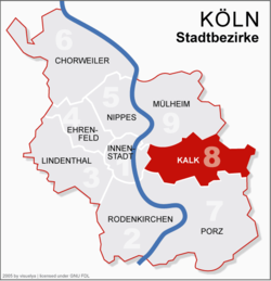 |
8th district Köln-Kalk | Brück, Höhenberg, Humboldt/Gremberg, Kalk, Merheim, Neubrück, Ostheim, Rath/Heumar, Vingst | 38.2 km² | 108.330 | 2.841/km² | Bezirksamt Kalk Kalker Hauptstraße 247–273, D-51103 Köln |
||
| 9th district Köln-Mülheim | Buchforst, Buchheim, Dellbrück, Dünnwald, Flittard, Höhenhaus, Holweide, Mülheim, Stammheim Stammheim, Cologne Stammheim is a municipal part of Cologne, Germany and part of the district of Mülheim. Stammheim lies on the right bank of the river Rhine, between Mülheim and Flittard... |
52.2 km² | 144.374 | 2.764/km² | Bezirksamt Mülheim Wiener Platz 2a, D-51065 Köln |
|||
| Cologne | 405.15 km² | 1.019.3282 | 2.516/km² | |||||
| Notes: 1: population as of 31. December 2008 2: Statistical records of the City of Cologne include "second home residents", which state records exclude. Cologne's population as by statistical records of the State of North Rhine-Westphalia was 1,000,298 on 31. May 2009 |
||||||||
Growth of urban area
Since the city's foundation in 38 BCColonia Claudia Ara Agrippinensium
Colonia Claudia Ara Agrippinensium was the name of the Roman colony in the Rhineland out of which the German city of Cologne developed.It was the capital of the Roman province of Germania Inferior and the headquarters of the military in the region. With the administrative reforms under Diocletian,...
, Cologne grew through numerous extensions and incorporation of surrounding municipalities. Since the construction of the Medieval wall in 1180, the area of the old imperial city
Free Imperial City
In the Holy Roman Empire, a free imperial city was a city formally ruled by the emperor only — as opposed to the majority of cities in the Empire, which were governed by one of the many princes of the Empire, such as dukes or prince-bishops...
of Cologne has not changed for more than 600 years and was only extended over the old city walls in 1794, just short before the arrival of French troops and Cologne's incorporation into the First French Empire
First French Empire
The First French Empire , also known as the Greater French Empire or Napoleonic Empire, was the empire of Napoleon I of France...
.
After 1815, the Kingdom of Prussia
Kingdom of Prussia
The Kingdom of Prussia was a German kingdom from 1701 to 1918. Until the defeat of Germany in World War I, it comprised almost two-thirds of the area of the German Empire...
enforced the construction of fortifications which again hindered any growth for the city. Only with the acquisition of these fortifications in 1881, the city of Cologne had the possibility of a gradual territorial expansion. On 12. November 1883 a strip of territory from parts of the municipalities of Ehrenfeld, Kriel, Longerich, Müngersdorf and Rondorf was added to the city. At the time of the industrial revolution
Industrial Revolution
The Industrial Revolution was a period from the 18th to the 19th century where major changes in agriculture, manufacturing, mining, transportation, and technology had a profound effect on the social, economic and cultural conditions of the times...
, industrial enterprises already avoided the densely populated areas inside of the city limits and settled in the small towns outside the fortified area, while maintaining close economic links to the city of Cologne. More than half of the estates here were in the hands of citizens of Cologne or the same becoming residents in these areas.
Since 1886, the Cologne City Council
Cologne City Hall
The City Hall is a historical building in Cologne, western Germany, located off Hohe Straße in the district of Innenstadt, set between the two squares of Rathausplatz and Alter Markt. It houses part of the city government, including the city council and offices of the Lord Mayor. It is...
intensified negotiations with the surrounding communities, and on 1 April 1888 ended in a first major incorporation. Since then the city has expanded with major reorganizations in 1910, 1914, 1922 and 1975.
| Date | Incorporated localities |
|---|---|
| 1 April 1888 | town of Deutz; town of Ehrenfeld and present day Neu-Ehrenfeld; part of the town of Kalk; parts of the town of Mülheim (Mülheimer Hafen); parts of the muni. of Efferen (present day Klettenberg); muni. of Kriel (Braunsfeld, Kriel, Lind, Lindenthal, Sülz Sülz Sülz is a municipal part of Cologne, Germany and part of the district of Lindenthal. Sülz lies on Luxemburger Straße between Lindenthal and Klettenberg. Sülz has 35.475 inhabitants and covers an area of 5,17 km² .The name Sülz goes back to Sulpece, first mentioned in 1145 as a possession of... ); muni. of Longerich (Butzweiler, Heimersdorf, Lindweiler, Longerich, Niehl, Stallagsberg, Volkhoven, Weidenpesch; muni. of Müngersdorf (Bickendorf, Bocklemünd, Melaten, Mengenich, Müngersdorf, Ossendorf, Vogelsang); muni. of Nippes (Mauenheim, Nippes, Riehl); muni. of Poll (Humboldt-Gremberg, Poll); parts of muni. of Rondorf (Arnoldshöhe, Bayenthal Bayenthal Bayenthal is a small municipal part of Cologne, Germany and part of the district of Rodenkirchen. Bayenthal lies on the left bank of the river Rhine, between the district of Innenstadt to the North and Marienburg to the South. The borders to these are defined by the Southern Bridge and the... , Klettenberg, Mansfeld, Marienburg, Raderberg, Raderthal, Weißhaus, Zollstock) |
| 1 April 1910 | Höhenberg; Humboldt-Gremberg; town of Kalk; Ostheim; muni. of Vingst |
| 1 April 1914 | town of Mülheim (incl. Buchforst, Buchheim, Kleinbert); from Landkreis Mülheim: Bürgermeisterei Merheim (Brück, Dellbrück, Dünnwald, Flittard, Hardt, Höhenberg, Höhenhaus, Holweide, Kunstfeld, Merheim, Ostheim, Rath, Rodderhof, Scheuerhof, Schlagbaum, Stammheim Stammheim, Cologne Stammheim is a municipal part of Cologne, Germany and part of the district of Mülheim. Stammheim lies on the right bank of the river Rhine, between Mülheim and Flittard... ) |
| 1 April 1922 | parts of Landgemeinde Worringen: Fühlingen (incl. Feldkassel, Kasselberg, Langel, Rheinkassel), Merkenich, Roggendorf, Thenhoven, Weiler, Worringen; parts of the muni. of Longerich |
| 1 January 1975 | town of Porz Porz Porz is a city district or Stadtbezirk of Cologne, Germany. It is situated on the right side of the Rhine in the south-east of the city... (Eil, Elsdorf, Ensen, Flughafen Cologne Bonn Airport Cologne/Bonn Airport is an international airport located in the district of Porz in the city of Cologne, Germany, and is surrounded by the Wahner Heide nature reserve. The airport is centrally located in the Cologne/Bonn Region southeast of Cologne city centre and northeast of Bonn... , Gremberghoven, Grengel, Heumar, Langel, Libur, Lind, Porz, Urbach, Wahn, Wahn-Heide, Westhoven, Zündorf Zündorf Zündorf is a suburb of Cologne, Germany and part of the district of Porz. Zündorf lies on the right bank of the river Rhine, between Langel and Porz. Zündorf has 12.229 inhabitants and covers an area of 8,12 km².... ); parts of the muni. of Brauweiler (Rath, Gut Vogelsang, Widdersdorf); parts of the town of Frechen Frechen Frechen is a town in the Rhein-Erft-Kreis, in North Rhine-Westphalia, Germany. Frechen was first mentioned in 877. It is situated at the western Cologne city border.... (Horbell, Marsdorf); parts of the muni. of Lövenich; muni. of Rodenkirchen Rodenkirchen Rodenkirchen is a southern city district of Cologne in Germany. It has about 100,000 inhabitants and covers as an area of 54.56 square kilometres... (Giesdorf, Godorf, Hahnwald, Hochkirchen, Höningen, Immendorf, Konraderhöhe, Meschenich, Rodenkirchen, Rondorf, Sürth, Weiß); parts of muni. of Sinnersdorf (Auweiler, Esch, Pesch, Gut Stöckheim); parts of the town of Brühl Brühl -Places and locations:Germany* Brühl * Brühl * Brühl , a street in LeipzigPoland* Brühl Palace, Warsaw-People:* Alois Friedrich von Brühl , a Polish-Saxon diplomat, politician, soldier, actor and playwright... ; parts of the munis. of Bornheim Bornheim Bornheim is a town in the Rhein-Sieg district, in North Rhine-Westphalia, Germany. It is situated on the West bank of the Rhine, approx. 10 km north-west of Bonn, 20 km south of Cologne.... , Hürth Hürth Hürth is a town in the Rhein-Erft-Kreis, North Rhine-Westphalia, Germany. Hürth shares borders with the city of Cologne.-Geography:Hürth is situated about 9 km to the southwest of Cologne city centre, at the northeastern slope of the natural preserve Kottenforst-Ville.The town, consisting of... , Pulheim Pulheim Pulheim is a city in the Rhein-Erft-Kreis, North Rhine-Westphalia, Germany.Since the 1920s, a large substation of the RWE has been sited at Pulheim... and Rösrath Rösrath Rösrath is a city in the Rheinisch-Bergischer Kreis in North Rhine-Westphalia, Germany. The earliest known documents mentioning the settlement Rösrath can be found in documents dated to 1356. There have been findings of Paleolithic and Mesolithic tools in the city area Forsbach... . |
Source: Historical Archive of the City of Cologne