
Dhawalagiri Zone
Encyclopedia
Dhawalagiri is one of the fourteen zones of Nepal
. It comes under the Western division of Nepal. Baglung
is the headquarters of this zone. Famous trekking areas like Mustang
, Muktinath
, Kali Gandaki valley
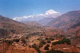
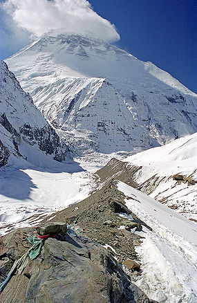
and Mt Dhaulagiri
fall in this zone. Dhorpatan Hunting Reserve
, the only hunting reserve in Nepal is spread over Baglung
and Myagdi district
s of this Zone.
Dhawalagiri is divided into 4 districts, listed below with the headquarters in parentheses:
See also:
Nepal
Nepal , officially the Federal Democratic Republic of Nepal, is a landlocked sovereign state located in South Asia. It is located in the Himalayas and bordered to the north by the People's Republic of China, and to the south, east, and west by the Republic of India...
. It comes under the Western division of Nepal. Baglung
Baglung
Baglung, is a town in western Nepal, 275 km west of Kathmandu. It is the administrative headquarters of Baglung District and Dhawalagiri Zone. Baglung is a major business, financial, educational, and healthcare center for the people of Kali Gandaki valley....
is the headquarters of this zone. Famous trekking areas like Mustang
Mustang District
Mustang District, a part of Dhawalagiri Zone, is one of the seventy-five districts of Nepal, a landlocked country of South Asia. The district, with Jomsom as its headquarters, covers an area of 3,573 km² and has a population of 14,981....
, Muktinath
Muktinath
Muktinath is a sacred place both for Hindus and Buddhists located in Muktinath Valley at an altitude of 3,710 meters at the foot of the Thorong La mountain pass , Mustang district, Nepal...
, Kali Gandaki valley
Kali Gandaki Gorge
The Kali Gandaki Gorge or Andha Galchi is the gorge of the Kali Gandaki in the Himalayas in Nepal, by some measures the deepest gorge in the world....
and Mt Dhaulagiri
Dhaulagiri
Dhaulagiri is Earth's seventh highest mountain at ; one of fourteen over eight thousand metres. Dhaulagiri was first climbed May 13, 1960 by a Swiss/Austrian expedition....
fall in this zone. Dhorpatan Hunting Reserve
Dhorpatan Hunting Reserve
The Dhorpatan Hunting Reserve is the only hunting reserve in Nepal. Established in 1987 it covers an area of in the Dhaulagiri Himal of western Nepal in the Rukum, Myagdi and Baglung Districts. In altitude it ranges from .-External links:*...
, the only hunting reserve in Nepal is spread over Baglung
Baglung District
Baglung District, of 268,938.Baglung is surrounded by Parvat, Myagdi, Rukum, Ropla, Pyuthan and Gulmi districts. It looks like Nepal in shape. It has 59 Village Development Committees and one Municipality. It has many rivers and streams and so, many suspension bridges. Baglung is also known as the...
and Myagdi district
Myagdi District
-Village Development Committees :*Arman*Arthunge*Babiyachaur*Baranja*Begkhola*Bhakilmi*Bima*Chimkhola*Dagnam*Dana*Darwang*Devisthan*Dhatan*Dowa*Gurja Khani*Histhan Mandali*Jhin*Jyamrukot*Kuhunkot*Kuinemangale*Lulang*Malkwang*Marang*Mudi...
s of this Zone.
Dhawalagiri is divided into 4 districts, listed below with the headquarters in parentheses:
- Baglung DistrictBaglung DistrictBaglung District, of 268,938.Baglung is surrounded by Parvat, Myagdi, Rukum, Ropla, Pyuthan and Gulmi districts. It looks like Nepal in shape. It has 59 Village Development Committees and one Municipality. It has many rivers and streams and so, many suspension bridges. Baglung is also known as the...
(BaglungBaglungBaglung, is a town in western Nepal, 275 km west of Kathmandu. It is the administrative headquarters of Baglung District and Dhawalagiri Zone. Baglung is a major business, financial, educational, and healthcare center for the people of Kali Gandaki valley....
) - Mustang DistrictMustang DistrictMustang District, a part of Dhawalagiri Zone, is one of the seventy-five districts of Nepal, a landlocked country of South Asia. The district, with Jomsom as its headquarters, covers an area of 3,573 km² and has a population of 14,981....
(JomsomJomsomJomsom , also known as Dzongsam or New Fort, is a town located at an altitude of 2800m in Mustang, Nepal. It extends over both the banks of the Kali Gandaki River. Along the banks of Kali Gandaki river there are rocks holy to the Hindus. The soaring peaks of Dhaulagiri and Nilgiri form a backdrop...
) - Myagdi DistrictMyagdi District-Village Development Committees :*Arman*Arthunge*Babiyachaur*Baranja*Begkhola*Bhakilmi*Bima*Chimkhola*Dagnam*Dana*Darwang*Devisthan*Dhatan*Dowa*Gurja Khani*Histhan Mandali*Jhin*Jyamrukot*Kuhunkot*Kuinemangale*Lulang*Malkwang*Marang*Mudi...
(Beni) - Parbat DistrictParbat DistrictParbat District of 157,826.It is mainly famous for the Gupteshowr Cave, which is visited by thousands of pilgrims during Shivaratri. It is also noted for the Dahere Deurali Temple, which is visited by thousands of pilgrims during Balachaturdanshai....
(KusmaKusma, NepalKusma is the headquarter of Parbat District, one of a district among 75 districts in Nepal, which lies in the western part of Nepal just about 57 Km away from one of a famous city of Nepal, Pokhara. Kusma falls under Western Development Region and Dhaoolagiri Zone of Nepal.It is located at...
)
See also:
- Zones of NepalZones of NepalNepal is divided into 14 administrative zones , and 75 districts . The 14 administrative zones are grouped into five development regions...
- Districts of NepalDistricts of NepalNepal's 14 administrative zones are subdivided into 75 districts . These districts are listed below, by zone...
- Regions of NepalRegions of NepalNepal is divided into 14 administrative zones , which are divided into 75 districts . The 14 administrative zones are grouped into five development regions...