

Del Rio, Tennessee
Encyclopedia
Del Rio is an unincorporated community
in Cocke County, Tennessee
, United States
. Although it is not a census-designated place
, the ZIP Code Tabulation Area
for the ZIP Code
(37727) that serves Del Rio had a population of 2,138, according to the 2000 census
.
of 2000, there were 2,138 people, 1,119 households, and 611 families residing in the Zip Code Tabulation Area for the zip code (37727) that serves Del Rio. The racial makeup of this area was 98.2% White, 0.1% Native American and 0.1% African American. Hispanics and Latinos comprise 0.7% of the population.
Of the 2,091 households, 21.2% had children under the age of 18 living with them, 55.6% were married couples
living together, 9.9% had a female householder with no husband present, and 29.7% were non-families. 25.8% of all households were made up of individuals and 10.8% had someone living alone who was 65 years of age or older. The average household size was 2.46 and the average family size was 2.95.
76.8% of the population was 18 years of age or older with 12.4% being 65 years of age or older. The median age was 39.7 years. The population was 50.5% male and 49.5% female.
The median income for a household in the area was $23,333, and the median income for a family was $28,504. The per capita income
for the area was $11,656. About 18.2% of families and 22.0% of the population were below the poverty line.
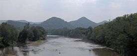
 Del Rio is located at 35°55′11"N 83°01′33"W (35.9197, -83.0258).http://www.topoquest.com/map.asp?lat=35.91972&lon=-83.02583 The community is situated around the confluence of the French Broad River
and Big Creek, the latter of which has its source high in the mountains to the south. In recent years, the town's central area has shifted to the junction of U.S. Route 70
and Tennessee Highway 107, along the north side of the French Broad.
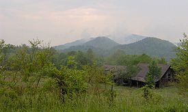
The Appalachian Mountains
surround Del Rio on all sides, and, along with the river, have been the key influence on the town's economic and cultural development. Stone Mountain rises some 2000 feet (609.6 m) above Del Rio to the west. Snowbird Mountain and Max Patch
Bald, both of which are traversed by the Appalachian Trail
, rise over 3000 feet (914.4 m) to the south. The Bald Mountains
are to the east, and Neddy Mountain and Meadow Creek Mountain are to the north. The Cherokee National Forest
borders much of Del Rio to the south and east.
Along US-70, Newport, Tennessee
is just over 10 miles (16.1 km) to the west, and Hot Springs, North Carolina
is nearly 15 miles (24.1 km) to the east. Del Rio is roughly halfway between Knoxville, Tennessee and Asheville, North Carolina. TN-107 connects Del Rio to a remote valley known as Lemon Gap, at the base of Max Patch Bald.
Like most Appalachian communities, Del Rio has several "satellite" towns, formed as early settlers branched out over the limited bottomlands in the mountain gaps and narrow coves. Among these are Nough (sometimes called "Slabtown") along Big Creek to the south, Paint Rock, which is further up the French Broad to the east, and Harmony Grove, to the southeast. Nough is the birthplace of opera singer and actress, Grace Moore
. The Catherine Marshall
novel, Christy, takes place at Chapel Hollow (called "Cutter Gap" in the novel), a small valley just west of Del Rio.
 A Native American
village once occupied the site along the French Broad River where Del Rio is now situated. Frank Stokely, who lived in the area in the mid-20th century, collected a large number of artifacts left by the natives of this village and displayed them in a small museum. The Knoxville Chapter of the Tennessee Archaeological Society also conducted excavations in the area.
The first European settler in what is now Del Rio was John Huff (1758–1843), a veteran of the American Revolution
, and his wife Mary Corder (1766–1842). Huff, a hunter and trapper, received a 400 acres (1.6 km²) land grant at the confluence of Long Creek and the French Broad. Arriving around 1784, the Huffs erected a small blockhouse known as Huff's Fort, which would serve as a stopping post for stagecoaches traveling between Knoxville, Tennessee and Warm Springs (now Hot Springs) in North Carolina. The community that arose in the vicinity became known as Big Creek.
Shortly after the Huffs arrived, another Revolutionary War veteran, Jehu Stokely (1747–1816) settled in the Big Creek area. According to family lore, Stokely was impressed into the British navy, but escaped and fought under American captain John Paul Jones
. Stokely's tract was just over three miles (5 km) east of Huff's Fort. John Fugate (1764–1837), also a veteran of the Revolution, settled in the Paint Rock area. In 1986, the community held a ceremony marking Fugate's grave as a Revolutionary War hero.
In the decade following Huff's arrival, the constant stream of Euro-American settlers into East Tennessee agitated the Cherokee
, who had lived and hunted in the region for centuries. Cattle were stolen, and some settlers were scalped and murdered, leading to massive reprisal attacks on Cherokee villages. Between 1783, a series of forts sprang in Cocke County along the Pigeon River
and French Broad, one being Wood's Fort near modern Edwina, just west of Del Rio. Historian J.G.M. Ramsey reports that by 1793, a series of blockhouses lined the French Broad, including the previously-mentioned Huff's (which Ramsey spells "Hough's"), one at Paint Rock, one at Burnt Cane, and another at Warm Springs. Guards stationed at the blockhouses regularly patrolled the area. A treaty at the Tellico Blockhouse
in 1794 eased much of the violence, although sporadic attacks occurred for years afterward.
 As the threat of Cherokee attacks declined, Big Creek slowly transformed itself into a stopping point for pioneers crossing the mountains en route to Tennessee. The Huff family converted their fort to an inn, and Jehu's son, Royal, opened a frontier trading post. Throughout the 19th century, the Allen family operated a 13-room log inn at nearby Wolf Creek. Most early settlers raised cattle, which they would drive across the mountains to sell in North Carolina.
Big Creek received a major economic boost in 1868, when the Southern Railway established a railroad line between Morristown, Tennessee
and Wolf Creek. Big Creek Station was established in 1870 near what is now the old post office, just south of the river. While the railroad brought benefits, it also brought confusion in the postal system, since there was another town in Tennessee already using the name "Big Creek." The town decided to change its name, and after weighing several suggestions, chose the name Del Rio, which is Spanish for "by the river."
The newly-named Del Rio quickly grew into a major shipping hub for lumber and shingles. Cocke County's first newspaper, The Excelsior, was established at Del Rio in 1875. In the 1880s and 1890s, high demand and innovations such as the band saw
brought about a boom in the lumber industry. After lowland forests were wiped out, lumber companies turned to the ancient forests of Appalachia to satisfy the increasing demand. Del Rio, perfectly situated at the base of the mountains, had become the center of a large logging operation by 1900. Lumber camps crept deeper and deeper up the mountain slopes, with the high camp of Boomer operating at 3000 feet (914.4 m), near the source of Big Creek, some 10 miles (16.1 km) south of Del Rio.
 Grace Moore, Del Rio's most famous resident, was born in Nough in 1898. Moore was the great-great-granddaughter of Jehu Stokely, one of Del Rio's original settlers.http://wc.rootsweb.com/cgi-bin/igm.cgi?op=GET&db=tarabar&id=I0084 She was probably born in the home of her maternal grandparents, William and Emma Stokely, which sat on the west bank of Big Creek near the entrance to Nough. A Tennessee Historical Commission marker now recalls the site on TN-107, although the house no longer stands.
James R. Stokely and John Stokely— also great-great-grandchildren of Jehu— formed the Stokely Brothers Company, based in nearby Newport.http://wc.rootsweb.com/cgi-bin/igm.cgi?op=GET&db=joan-&id=I0154 The company would later be known nationally as Stokely-Van Camp's, and is now a subsidiary of ConAgra.
In 1911, the Weeks Act
put an end to the massive logging operations in Southern Appalachia, and Del Rio began to decline. The Great Smoky Mountains National Park
didn't extend to cover Snowbird or Max Patch, so Del Rio missed out on the tourism boom that made towns such as Gatlinburg wealthy. Mary Bell Smith, who taught at an elementary school near Nough in the 1930s, recalled elements of the poverty she witnessed during this period:
Another economic blow for Del Rio came with the Interstate Highway Act. For decades, US-70 had been the main highway between Knoxville and Asheville, passing through Del Rio just before it ascended (or emerged from) the mountains. The new Interstate 40
, however, ascended the mountains at Hartford, Tennessee
to the south, rather than at Del Rio. Thus, the town's thru-traffic slowly died out.
, which is just over Stone Mountain to the west, Del Rio gained a reputation for moonshining during the first half of the 20th-century. Moonshining wasn't uncommon in Appalachian communities, where poor soil and low corn prices drove farmers to illegally distill liquor to supplement their income. Long-time Del Rio resident Nathan Jones stated that while moonshining occurred it was typically low-scale and mostly for personal use.
While Del Rio's moonshining image may be exaggerated, Jones did acknowledge that cockfighting was common in the community as early as the 1950s . Twice in the 1980s, federal agents raided an operation just off Happy Hollow Road known as "The Del Rio Cockfighting Pit". On June 11, 2005 the pit was again raided by federal agents, resulting 143 arrests and a seizure of more than $40,000 in cash. Federal officials described the pit as the "largest and oldest illegal cockfighting pit" in the United States.
Unincorporated area
In law, an unincorporated area is a region of land that is not a part of any municipality.To "incorporate" in this context means to form a municipal corporation, a city, town, or village with its own government. An unincorporated community is usually not subject to or taxed by a municipal government...
in Cocke County, Tennessee
Tennessee
Tennessee is a U.S. state located in the Southeastern United States. It has a population of 6,346,105, making it the nation's 17th-largest state by population, and covers , making it the 36th-largest by total land area...
, United States
United States
The United States of America is a federal constitutional republic comprising fifty states and a federal district...
. Although it is not a census-designated place
Census-designated place
A census-designated place is a concentration of population identified by the United States Census Bureau for statistical purposes. CDPs are delineated for each decennial census as the statistical counterparts of incorporated places such as cities, towns and villages...
, the ZIP Code Tabulation Area
ZIP Code Tabulation Area
ZIP Code Tabulation Areas are statistical entities developed by the United States Census Bureau for tabulating summary statistics from Census 2000. This new entity was developed to overcome the difficulties in precisely defining the land area covered by each ZIP code...
for the ZIP Code
ZIP Code
ZIP codes are a system of postal codes used by the United States Postal Service since 1963. The term ZIP, an acronym for Zone Improvement Plan, is properly written in capital letters and was chosen to suggest that the mail travels more efficiently, and therefore more quickly, when senders use the...
(37727) that serves Del Rio had a population of 2,138, according to the 2000 census
United States Census, 2000
The Twenty-second United States Census, known as Census 2000 and conducted by the Census Bureau, determined the resident population of the United States on April 1, 2000, to be 281,421,906, an increase of 13.2% over the 248,709,873 persons enumerated during the 1990 Census...
.
Demographics
As of the censusCensus
A census is the procedure of systematically acquiring and recording information about the members of a given population. It is a regularly occurring and official count of a particular population. The term is used mostly in connection with national population and housing censuses; other common...
of 2000, there were 2,138 people, 1,119 households, and 611 families residing in the Zip Code Tabulation Area for the zip code (37727) that serves Del Rio. The racial makeup of this area was 98.2% White, 0.1% Native American and 0.1% African American. Hispanics and Latinos comprise 0.7% of the population.
Of the 2,091 households, 21.2% had children under the age of 18 living with them, 55.6% were married couples
Marriage
Marriage is a social union or legal contract between people that creates kinship. It is an institution in which interpersonal relationships, usually intimate and sexual, are acknowledged in a variety of ways, depending on the culture or subculture in which it is found...
living together, 9.9% had a female householder with no husband present, and 29.7% were non-families. 25.8% of all households were made up of individuals and 10.8% had someone living alone who was 65 years of age or older. The average household size was 2.46 and the average family size was 2.95.
76.8% of the population was 18 years of age or older with 12.4% being 65 years of age or older. The median age was 39.7 years. The population was 50.5% male and 49.5% female.
The median income for a household in the area was $23,333, and the median income for a family was $28,504. The per capita income
Per capita income
Per capita income or income per person is a measure of mean income within an economic aggregate, such as a country or city. It is calculated by taking a measure of all sources of income in the aggregate and dividing it by the total population...
for the area was $11,656. About 18.2% of families and 22.0% of the population were below the poverty line.
Geography
French Broad River
The French Broad River flows from near the village of Rosman in Transylvania County, North Carolina, into the state of Tennessee. Its confluence with the Holston River at Knoxville is the beginning of the Tennessee River....
and Big Creek, the latter of which has its source high in the mountains to the south. In recent years, the town's central area has shifted to the junction of U.S. Route 70
U.S. Route 70
U.S. Route 70 is an east–west United States highway that runs for 2,385 miles from eastern North Carolina to east-central Arizona. As can be derived from its number, it is a major east–west highway of the Southern and Southwestern United States...
and Tennessee Highway 107, along the north side of the French Broad.
The Appalachian Mountains
Appalachian Mountains
The Appalachian Mountains #Whether the stressed vowel is or ,#Whether the "ch" is pronounced as a fricative or an affricate , and#Whether the final vowel is the monophthong or the diphthong .), often called the Appalachians, are a system of mountains in eastern North America. The Appalachians...
surround Del Rio on all sides, and, along with the river, have been the key influence on the town's economic and cultural development. Stone Mountain rises some 2000 feet (609.6 m) above Del Rio to the west. Snowbird Mountain and Max Patch
Max Patch
Max Patch is a bald mountain on the North Carolina-Tennessee Border in Madison County, North Carolina and Cocke County, Tennessee. It is a major landmark along the Tennessee/North Carolina section of the Appalachian Trail, although its summit is located in North Carolina...
Bald, both of which are traversed by the Appalachian Trail
Appalachian Trail
The Appalachian National Scenic Trail, generally known as the Appalachian Trail or simply the AT, is a marked hiking trail in the eastern United States extending between Springer Mountain in Georgia and Mount Katahdin in Maine. It is approximately long...
, rise over 3000 feet (914.4 m) to the south. The Bald Mountains
Bald Mountains
The Bald Mountains are a mountain range rising along the border between Tennessee and North Carolina in the southeastern United States. They are part of the Blue Ridge Mountain Province of the Southern Appalachian Mountains...
are to the east, and Neddy Mountain and Meadow Creek Mountain are to the north. The Cherokee National Forest
Cherokee National Forest
The Cherokee National Forest is a large National Forest created on July 19, 1936, by U.S. President Franklin Roosevelt, operated by the U.S. Forest Service and encompassing some 640,000 acres .-Location:...
borders much of Del Rio to the south and east.
Along US-70, Newport, Tennessee
Newport, Tennessee
Newport is a city in Cocke County, Tennessee, United States. The population was 7,242 at the 2000 census. It is the county seat of Cocke County.-Geography:...
is just over 10 miles (16.1 km) to the west, and Hot Springs, North Carolina
Hot Springs, North Carolina
Hot Springs is a town in Madison County, North Carolina, United States. The population was 645 at the 2000 census. It is part of the Asheville Metropolitan Statistical Area.-Geography:Hot Springs is located at ....
is nearly 15 miles (24.1 km) to the east. Del Rio is roughly halfway between Knoxville, Tennessee and Asheville, North Carolina. TN-107 connects Del Rio to a remote valley known as Lemon Gap, at the base of Max Patch Bald.
Like most Appalachian communities, Del Rio has several "satellite" towns, formed as early settlers branched out over the limited bottomlands in the mountain gaps and narrow coves. Among these are Nough (sometimes called "Slabtown") along Big Creek to the south, Paint Rock, which is further up the French Broad to the east, and Harmony Grove, to the southeast. Nough is the birthplace of opera singer and actress, Grace Moore
Grace Moore
Grace Moore was an American operatic soprano and actress in musical theatre and film. She was nicknamed the "Tennessee Nightingale." Her films helped to popularize opera by bringing it to a larger audience.-Early life:...
. The Catherine Marshall
Catherine Marshall
Catherine Wood Marshall was an American author of nonfiction, inspirational, and fiction works. She was the wife of well-known minister Peter Marshall.-Biography:...
novel, Christy, takes place at Chapel Hollow (called "Cutter Gap" in the novel), a small valley just west of Del Rio.
Early history
Native Americans in the United States
Native Americans in the United States are the indigenous peoples in North America within the boundaries of the present-day continental United States, parts of Alaska, and the island state of Hawaii. They are composed of numerous, distinct tribes, states, and ethnic groups, many of which survive as...
village once occupied the site along the French Broad River where Del Rio is now situated. Frank Stokely, who lived in the area in the mid-20th century, collected a large number of artifacts left by the natives of this village and displayed them in a small museum. The Knoxville Chapter of the Tennessee Archaeological Society also conducted excavations in the area.
The first European settler in what is now Del Rio was John Huff (1758–1843), a veteran of the American Revolution
American Revolutionary War
The American Revolutionary War , the American War of Independence, or simply the Revolutionary War, began as a war between the Kingdom of Great Britain and thirteen British colonies in North America, and ended in a global war between several European great powers.The war was the result of the...
, and his wife Mary Corder (1766–1842). Huff, a hunter and trapper, received a 400 acres (1.6 km²) land grant at the confluence of Long Creek and the French Broad. Arriving around 1784, the Huffs erected a small blockhouse known as Huff's Fort, which would serve as a stopping post for stagecoaches traveling between Knoxville, Tennessee and Warm Springs (now Hot Springs) in North Carolina. The community that arose in the vicinity became known as Big Creek.
Shortly after the Huffs arrived, another Revolutionary War veteran, Jehu Stokely (1747–1816) settled in the Big Creek area. According to family lore, Stokely was impressed into the British navy, but escaped and fought under American captain John Paul Jones
John Paul Jones
John Paul Jones was a Scottish sailor and the United States' first well-known naval fighter in the American Revolutionary War. Although he made enemies among America's political elites, his actions in British waters during the Revolution earned him an international reputation which persists to...
. Stokely's tract was just over three miles (5 km) east of Huff's Fort. John Fugate (1764–1837), also a veteran of the Revolution, settled in the Paint Rock area. In 1986, the community held a ceremony marking Fugate's grave as a Revolutionary War hero.
In the decade following Huff's arrival, the constant stream of Euro-American settlers into East Tennessee agitated the Cherokee
Cherokee
The Cherokee are a Native American people historically settled in the Southeastern United States . Linguistically, they are part of the Iroquoian language family...
, who had lived and hunted in the region for centuries. Cattle were stolen, and some settlers were scalped and murdered, leading to massive reprisal attacks on Cherokee villages. Between 1783, a series of forts sprang in Cocke County along the Pigeon River
Pigeon River
The Pigeon River may refer to:* Pigeon River , between Minnesota, USA and Ontario, Canada in North America*One of four rivers named the Pigeon River in Michigan, USA...
and French Broad, one being Wood's Fort near modern Edwina, just west of Del Rio. Historian J.G.M. Ramsey reports that by 1793, a series of blockhouses lined the French Broad, including the previously-mentioned Huff's (which Ramsey spells "Hough's"), one at Paint Rock, one at Burnt Cane, and another at Warm Springs. Guards stationed at the blockhouses regularly patrolled the area. A treaty at the Tellico Blockhouse
Tellico Blockhouse
The Tellico Blockhouse was an early American outpost located along the Little Tennessee River in Vonore, Monroe County, Tennessee. Completed in 1794, the blockhouse operated until 1807 with the purpose of keeping the peace between nearby Overhill Cherokee towns and early Euro-American settlers in...
in 1794 eased much of the violence, although sporadic attacks occurred for years afterward.
19th century
Big Creek received a major economic boost in 1868, when the Southern Railway established a railroad line between Morristown, Tennessee
Morristown, Tennessee
Morristown is a city in, and the county seat of, Hamblen County, Tennessee, United States. The population was 29,137 at the 2010 United States Census. It is the principal city of the Morristown, Tennessee Metropolitan Statistical Area, which encompasses all of Grainger, Hamblen and Jefferson counties...
and Wolf Creek. Big Creek Station was established in 1870 near what is now the old post office, just south of the river. While the railroad brought benefits, it also brought confusion in the postal system, since there was another town in Tennessee already using the name "Big Creek." The town decided to change its name, and after weighing several suggestions, chose the name Del Rio, which is Spanish for "by the river."
The newly-named Del Rio quickly grew into a major shipping hub for lumber and shingles. Cocke County's first newspaper, The Excelsior, was established at Del Rio in 1875. In the 1880s and 1890s, high demand and innovations such as the band saw
Band saw
A bandsaw is a power tool which uses a blade consisting of a continuous band of metal with teeth along one edge to cut various workpieces. The band usually rides on two wheels rotating in the same plane, although some small bandsaws have three wheels. Bandsawing produces uniform cutting action as a...
brought about a boom in the lumber industry. After lowland forests were wiped out, lumber companies turned to the ancient forests of Appalachia to satisfy the increasing demand. Del Rio, perfectly situated at the base of the mountains, had become the center of a large logging operation by 1900. Lumber camps crept deeper and deeper up the mountain slopes, with the high camp of Boomer operating at 3000 feet (914.4 m), near the source of Big Creek, some 10 miles (16.1 km) south of Del Rio.
20th century
James R. Stokely and John Stokely— also great-great-grandchildren of Jehu— formed the Stokely Brothers Company, based in nearby Newport.http://wc.rootsweb.com/cgi-bin/igm.cgi?op=GET&db=joan-&id=I0154 The company would later be known nationally as Stokely-Van Camp's, and is now a subsidiary of ConAgra.
In 1911, the Weeks Act
Weeks Act
The Weeks Act is a federal law passed by the US Congress on 1 March 1911 in the United States. The law, introduced by Congressman John W. Weeks of Massachusetts, authorized the Secretary of Agriculture to "Examine, locate and recommend for purchase ... such lands within the watersheds of navigable...
put an end to the massive logging operations in Southern Appalachia, and Del Rio began to decline. The Great Smoky Mountains National Park
Great Smoky Mountains National Park
Great Smoky Mountains National Park is a United States National Park and UNESCO World Heritage Site that straddles the ridgeline of the Great Smoky Mountains, part of the Blue Ridge Mountains, which are a division of the larger Appalachian Mountain chain. The border between Tennessee and North...
didn't extend to cover Snowbird or Max Patch, so Del Rio missed out on the tourism boom that made towns such as Gatlinburg wealthy. Mary Bell Smith, who taught at an elementary school near Nough in the 1930s, recalled elements of the poverty she witnessed during this period:
Many students in large families brought their lunches in tin pails which had been emptied of the pure pork lard which was originally bought in them. These lunch pails contained either blackberry pie or dried beans and cornbread. Sharing equally, sisters and brothers dipped harmoniously from the same lunch bucket.
Another economic blow for Del Rio came with the Interstate Highway Act. For decades, US-70 had been the main highway between Knoxville and Asheville, passing through Del Rio just before it ascended (or emerged from) the mountains. The new Interstate 40
Interstate 40
Interstate 40 is the third-longest major east–west Interstate Highway in the United States, after I-90 and I-80. Its western end is at Interstate 15 in Barstow, California; its eastern end is at a concurrency of U.S. Route 117 and North Carolina Highway 132 in Wilmington, North Carolina...
, however, ascended the mountains at Hartford, Tennessee
Hartford, Tennessee
Hartford is an unincorporated community in Cocke County, Tennessee, located in the southeastern United States. Although it is not a census-designated place, the ZIP Code Tabulation Area for the ZIP Code that serves Hartford had a population of 814, according to the 2000 census.Hartford is the...
to the south, rather than at Del Rio. Thus, the town's thru-traffic slowly died out.
Problems with moonshining and cockfighting
Like its neighbor CosbyCosby, Tennessee
Cosby is an unincorporated community in Cocke County, Tennessee, United States. Although it is not a census-designated place, the ZIP Code Tabulation Area for the ZIP Code that serves Cosby had a population of 5,201 as of the 2000 U.S. Census...
, which is just over Stone Mountain to the west, Del Rio gained a reputation for moonshining during the first half of the 20th-century. Moonshining wasn't uncommon in Appalachian communities, where poor soil and low corn prices drove farmers to illegally distill liquor to supplement their income. Long-time Del Rio resident Nathan Jones stated that while moonshining occurred it was typically low-scale and mostly for personal use.
While Del Rio's moonshining image may be exaggerated, Jones did acknowledge that cockfighting was common in the community as early as the 1950s . Twice in the 1980s, federal agents raided an operation just off Happy Hollow Road known as "The Del Rio Cockfighting Pit". On June 11, 2005 the pit was again raided by federal agents, resulting 143 arrests and a seizure of more than $40,000 in cash. Federal officials described the pit as the "largest and oldest illegal cockfighting pit" in the United States.
External links
- Cocke County Chamber of Commerce
- Cocke County at TNGenWeb Project
- Ebenezer Mission location - TopoQuest.com
- Grace Moore Birthplace (appx.) - TopoQuest.com