

Cymric Oil Field
Encyclopedia
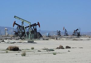
The Cymric Oil Field is a large oil field
in Kern County
, California
in the United States
. While only the 14th-largest oil field in California in total size, in terms of total remaining reserves it ranks fifth, with the equivalent of over 119 Moilbbl still in the ground. Production at Cymric has been increasing faster than at any other California oil field.
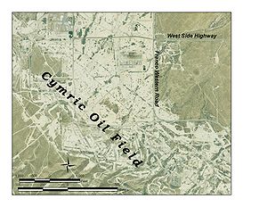
, between that highway and the Temblor Range
. It is north of the town of McKittrick
, which is at the junction of State Route 58
and 33. The field is approximately 11 miles (17.7 km) long, from northwest to southeast, and up to two miles (3 km) across, including several smaller discontiguous areas which are considered geologically to be part of the main field. Elevations on the field range from approximately 600 to 1000 feet (304.8 m).
 Adjacent to the Cymric Field on the south are the smaller fields of McKittrick
, Belgian Anticline and Railroad Gap, and on the east, along Route 33, is the small Monument Junction field. The enormous South Belridge Field
, one of the largest in California, begins about one mile (1.6 km) northeast of Cymric's northernmost extent.
The local climate is arid to semi-arid, and the predominant native groundcover is grassland and low scrub. In many areas of active oil field development, almost all vegetation has been removed.
formation known as the Tulare, which is divided into three units: the Tulare I, II, and Amnicola. All are of Pleistocene
age. The Tulare formation was created mainly in a braided stream and fan delta depositional environment
, while the depositional characteristics of the Amnicola suggest a lacustrine
(lake) environment, as well as braided stream. These kinds of rocks have high porosity
(around 35%) but low permeability, allowing considerable oil to accumulate in the formation, while a combination of structural and stratigraphic traps keep the oil from migrating further upward. Throughout the history of the field, these upper units have been the most productive, and they were also the first to be discovered, in 1909.
Other productive units include the Etchegoin, of Pliocene
age (this same unit is productive in many oil fields in the southwestern San Joaquin Valley); the Reef Ridge Formation, of Miocene
age; the McDonald/Devilwater pool in the Monterey Formation, of Miocene age; the Agua (Santos) pool in the Temblor formation, of Oligocene
age; and the Kreyenhagen Formation, of Eocene
age. One of the most productive pools of all, the Carneros pool in the Temblor Formation, was not discovered until 1946, but it reached its peak production just one year later, with over 2300000 barrels (365,670.8 m³) produced during that year from that pool alone.
Many of the pools, especially in the deeper units, were not found until the 1940s to the 1980s. Some are small and disconnected, trapped by faulting and impermeable units, often at considerable depth; for example, the Phacoides pool in the Temblor Formation is at 10145 feet (3,092.2 m) below ground surface, and the field operators did not find it until 1967. Oil from this unit, coming from so deep in the earth, emerges at the spectacular and dangerous temperature of 307 °F (152.8 °C). The deepest well in the entire Cymric field was one drilled by the Superior Oil Company, to a depth of 12022 feet (3,664.3 m), into the "Point of Rocks" formation, of Eocene age.
 The Nacirema Oil Company discovered the Cymric field in 1909, when they drilled into the huge Tulare pool with their Well No. 1. Unusual for San Joaquin Valley oil fields, peak production for Cymric did not occur early in the 20th century; the most barrels pumped in a single year was 11,673,403, in 1996. In 2006, the most recent year for which data was available, it had the fastest-growing production of any field in California.
Oil produced at Cymric is predominantly heavy crude, with specific gravity around 11-15 API
. Since it flows poorly, being highly viscous, much of the field is steamflooded
. This combination of water and heat assists the movement of petroleum towards production wells. Production wells on the Cymric field are often closely spaced, with some parts of the oil field having wells at 110 feet (33.5 m) spacing (5/8 acre).
Currently, the principal operators on the field are Chevron Corp., Aera Energy LLC
, and Plains Exploration and Production (PXP), which acquired former operator Nuevo Energy in 2004.
Oil field
An oil field is a region with an abundance of oil wells extracting petroleum from below ground. Because the oil reservoirs typically extend over a large area, possibly several hundred kilometres across, full exploitation entails multiple wells scattered across the area...
in Kern County
Kern County, California
Spreading across the southern end of the California Central Valley, Kern County is the fifth-largest county by population in California. Its economy is heavily linked to agriculture and to petroleum extraction, and there is a strong aviation and space presence. Politically, it has generally...
, California
California
California is a state located on the West Coast of the United States. It is by far the most populous U.S. state, and the third-largest by land area...
in the United States
United States
The United States of America is a federal constitutional republic comprising fifty states and a federal district...
. While only the 14th-largest oil field in California in total size, in terms of total remaining reserves it ranks fifth, with the equivalent of over 119 Moilbbl still in the ground. Production at Cymric has been increasing faster than at any other California oil field.
Setting
The Cymric field is in the Temblor Valley, along the west side of State Route 33California State Route 33
State Route 33 is a north–south state highway in the U.S. state of California. SR 33 replaced part of U.S. Route 399 in 1964 during the "great renumbering" of routes. In the unincorporated sections of Kern County it is known as the West Side Highway...
, between that highway and the Temblor Range
Temblor Range
The Temblor Range is a mountain range within the California Coast Ranges, at the southwestern extremity of the San Joaquin Valley in California in the United States. It runs in a northwest-southeasterly direction along the borders of Kern County and San Luis Obispo County. The name of the range is...
. It is north of the town of McKittrick
McKittrick, California
McKittrick is a census-designated place in Kern County, California, United States. McKittrick is located northwest of Taft, at an elevation of 1056 feet . The population was 115 at the 2010 census, down from 160 at the 2000 census.-Geography:...
, which is at the junction of State Route 58
California State Route 58
State Route 58 is an east-west highway across the California Coast Ranges, the southern San Joaquin Valley, the Tehachapi Mountains, which border the southern Sierra Nevada, and the Mojave Desert. It runs between its western terminus near Santa Margarita and its eastern terminus at Barstow...
and 33. The field is approximately 11 miles (17.7 km) long, from northwest to southeast, and up to two miles (3 km) across, including several smaller discontiguous areas which are considered geologically to be part of the main field. Elevations on the field range from approximately 600 to 1000 feet (304.8 m).
McKittrick Oil Field
The McKittrick Oil Field is a large oil and gas field in western Kern County, California. The town of McKittrick overlies the northeastern portion of the oil field...
, Belgian Anticline and Railroad Gap, and on the east, along Route 33, is the small Monument Junction field. The enormous South Belridge Field
South Belridge Oil Field
The South Belridge Oil Field is a large oil field in northwestern Kern County, San Joaquin Valley, California, about forty miles west of Bakersfield...
, one of the largest in California, begins about one mile (1.6 km) northeast of Cymric's northernmost extent.
The local climate is arid to semi-arid, and the predominant native groundcover is grassland and low scrub. In many areas of active oil field development, almost all vegetation has been removed.
Geology
Most of the oil in the Cymric field is in a sandstoneSandstone
Sandstone is a sedimentary rock composed mainly of sand-sized minerals or rock grains.Most sandstone is composed of quartz and/or feldspar because these are the most common minerals in the Earth's crust. Like sand, sandstone may be any colour, but the most common colours are tan, brown, yellow,...
formation known as the Tulare, which is divided into three units: the Tulare I, II, and Amnicola. All are of Pleistocene
Pleistocene
The Pleistocene is the epoch from 2,588,000 to 11,700 years BP that spans the world's recent period of repeated glaciations. The name pleistocene is derived from the Greek and ....
age. The Tulare formation was created mainly in a braided stream and fan delta depositional environment
Sedimentary depositional environment
In geology, sedimentary depositional environment describes the combination of physical, chemical and biological processes associated with the deposition of a particular type of sediment and, therefore, the rock types that will be formed after lithification, if the sediment is preserved in the rock...
, while the depositional characteristics of the Amnicola suggest a lacustrine
Lake
A lake is a body of relatively still fresh or salt water of considerable size, localized in a basin, that is surrounded by land. Lakes are inland and not part of the ocean and therefore are distinct from lagoons, and are larger and deeper than ponds. Lakes can be contrasted with rivers or streams,...
(lake) environment, as well as braided stream. These kinds of rocks have high porosity
Porosity
Porosity or void fraction is a measure of the void spaces in a material, and is a fraction of the volume of voids over the total volume, between 0–1, or as a percentage between 0–100%...
(around 35%) but low permeability, allowing considerable oil to accumulate in the formation, while a combination of structural and stratigraphic traps keep the oil from migrating further upward. Throughout the history of the field, these upper units have been the most productive, and they were also the first to be discovered, in 1909.
Other productive units include the Etchegoin, of Pliocene
Pliocene
The Pliocene Epoch is the period in the geologic timescale that extends from 5.332 million to 2.588 million years before present. It is the second and youngest epoch of the Neogene Period in the Cenozoic Era. The Pliocene follows the Miocene Epoch and is followed by the Pleistocene Epoch...
age (this same unit is productive in many oil fields in the southwestern San Joaquin Valley); the Reef Ridge Formation, of Miocene
Miocene
The Miocene is a geological epoch of the Neogene Period and extends from about . The Miocene was named by Sir Charles Lyell. Its name comes from the Greek words and and means "less recent" because it has 18% fewer modern sea invertebrates than the Pliocene. The Miocene follows the Oligocene...
age; the McDonald/Devilwater pool in the Monterey Formation, of Miocene age; the Agua (Santos) pool in the Temblor formation, of Oligocene
Oligocene
The Oligocene is a geologic epoch of the Paleogene Period and extends from about 34 million to 23 million years before the present . As with other older geologic periods, the rock beds that define the period are well identified but the exact dates of the start and end of the period are slightly...
age; and the Kreyenhagen Formation, of Eocene
Eocene
The Eocene Epoch, lasting from about 56 to 34 million years ago , is a major division of the geologic timescale and the second epoch of the Paleogene Period in the Cenozoic Era. The Eocene spans the time from the end of the Palaeocene Epoch to the beginning of the Oligocene Epoch. The start of the...
age. One of the most productive pools of all, the Carneros pool in the Temblor Formation, was not discovered until 1946, but it reached its peak production just one year later, with over 2300000 barrels (365,670.8 m³) produced during that year from that pool alone.
Many of the pools, especially in the deeper units, were not found until the 1940s to the 1980s. Some are small and disconnected, trapped by faulting and impermeable units, often at considerable depth; for example, the Phacoides pool in the Temblor Formation is at 10145 feet (3,092.2 m) below ground surface, and the field operators did not find it until 1967. Oil from this unit, coming from so deep in the earth, emerges at the spectacular and dangerous temperature of 307 °F (152.8 °C). The deepest well in the entire Cymric field was one drilled by the Superior Oil Company, to a depth of 12022 feet (3,664.3 m), into the "Point of Rocks" formation, of Eocene age.
History and production
Oil produced at Cymric is predominantly heavy crude, with specific gravity around 11-15 API
API gravity
The American Petroleum Institute gravity, or API gravity, is a measure of how heavy or light a petroleum liquid is compared to water. If its API gravity is greater than 10, it is lighter and floats on water; if less than 10, it is heavier and sinks...
. Since it flows poorly, being highly viscous, much of the field is steamflooded
Steam injection (oil industry)
Steam injection is an increasingly common method of extracting heavy oil. It is considered an enhanced oil recovery method and is the main type of thermal stimulation of oil reservoirs. There are several different forms of the technology, with the two main ones being Cyclic Steam Stimulation and...
. This combination of water and heat assists the movement of petroleum towards production wells. Production wells on the Cymric field are often closely spaced, with some parts of the oil field having wells at 110 feet (33.5 m) spacing (5/8 acre).
Currently, the principal operators on the field are Chevron Corp., Aera Energy LLC
Aera Energy LLC
Aera Energy LLC is a natural gas, oil exploration and production company jointly owned by Shell and ExxonMobil headquartered in Bakersfield, California...
, and Plains Exploration and Production (PXP), which acquired former operator Nuevo Energy in 2004.