
Cyclone Rosita
Encyclopedia
Severe Tropical Cyclone Rosita was a tropical cyclone
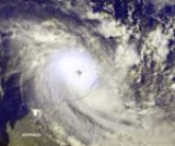
that affected northern Australia from 15 April through 21 April 2000. Rosita was one of the most intense tropical cyclones to hit the west Kimberley
coast in the last hundred years. Crossing the coast as a Category 5 about 40 kilometres (24.9 mi) south of Broome
on 20 April, Rosita caused severe damage in the Eco Beach resort and the vegetation around Broome. Its region of very destructive winds (gusts exceeding 170 km/h) passed south of Broome by only 15 kilometres (9.3 mi). Cyclone Rosita was the first cyclone to directly hit Broome since Cyclone Lindsay in March 1985.
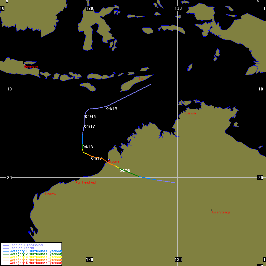
formed on 14 April, initially moving west south-west and turned southward during 16 April and 17 April. The low slowly strengthened and was named Rosita on 17 April, while located approximately 670 kilometres (416.3 mi) to the north of Port Hedland
at about 6 p.m. WST
(1000 UTC). On the morning of 18 April, a ship reported a relatively high pressure of 997 hPa
while passing very close to the centre of Cyclone Rosita, however, near-storm-force winds
were reported.
Rosita then entered a very favourable environment which allowed rapid development to occur. On 19 April, Rosita turned to the east-southeast and intensified rapidly to a Category 5 severe cyclone, with an estimated central pressure of 930 hPa. Wind gusts near the centre were estimated at about 290 km/h (180 mph). Rosita turned slightly to the southeast, crossing the coast at peak intensity, 40 kilometres (24.9 mi) south of Broome
at around 1 a.m. WST on 20 April (1700 UTC 19 April). Cyclone Rosita was a small cyclone, but nevertheless was very intense and powerful. Its radius of gale-force winds
was just half the average for cyclones in Australia, and its core of very destructive winds extended just 25 kilometres (15.5 mi) from its centre. This meant that Rosita’s region of very destructive winds missed Broome
by only 15 kilometres (9.3 mi) to the south. Once over land, Rosita accelerated to speeds of up to 30 km/h (19 mph) into the Great Sandy Desert
, only weakening gradually. Rosita passed close to the community of Balgo
at around 10 p.m. WST (1400 UTC) on 20 April, about 700 kilometres (435 mi) from the coast. Rosita was still estimated to be at Category 1 intensity when it passed near the community. Rosita’s remnants continued to bring flooding rains to central Australia.
predicted Rosita to hit near Broome at around midnight WST on 20 April (1600 UTC 19 April). Towns around the area were warned to prepare for one of the most powerful cyclones ever to threaten Australia. Very destructive winds with gusts to 260 km/h near the cyclone's centre were expected. Residents of coastal towns were warned to expect dangerous storm tides – local emergency officials said an 8 metre (26 ft) high tide was expected at that night. Tourists in the area were warned not to try to reach Broome. Chevron
Australia said a tanker due to arrive on 18 April was asked to delay its arrival till 22 April because of the cyclone. Iron ore miners in Port Hedland
and Dampier
monitored Rosita's approach.
Blue Alert warnings, which indicate that a cyclone may affect the warning area within 48 hours, were issued for Cyclone Rosita on the morning on 19 April. They were upgraded to a Yellow Alert – an indication that a cyclone appears inevitable to affect the warning area in 12 hours – at 1 pm, then to a Red Alert – meaning the cyclone is imminent – at 8 pm. In general, residents were well informed of the warnings through the radio. Residents from the low-lying downtown areas evacuated to homes in more elevated locations. Two of the three available evacuation shelters were opened and co-ordinated by the Department of Family and Children's Services. 280 people took shelter in schools, while 78 residents from Bidyadanga were evacuated to Port Hedland or Broome. The people that stayed in the settlement sheltered in the church and family homes. Staff and guests at the Eco Beach tourist resort received warnings from Rosita early on 19 April and made a timely return to Broome before the cyclone hit.
. The main homestead on the Thangoo station, 28 km (17.4 mi) to the south-southeast of Broome, received only minor structural damage, however the station was in the region of the dangerous storm surge. Reports from the Thangoo station, situated 2.5 km (1.6 mi) inland from coastal mangroves, showed that the station’s front gate had debris laid up to the second shoreline, about a metre (3.3 ft) above mean ground level. Another station homestead, 7 km (4.3 mi) west, was covered by coastal dunes but escaped major damage to its structure.
The most severe structural damage occurred near Cape Villaret, 40 km (24.9 mi) south-southwest of Broome
. The Eco-beach tourist resort and the Yardoogarra station were devastated. The area around the homestead was totally devastated. A caravan parked nearby was blown away and crumbled, and a semi trailer was blown to its side. The vegetation, which used to be very lush, was stripped of all leaves by the destructive winds which carried airborne salt and sand. The damage to the vegetation seemed to be worse than the tree damage seen in Exmouth
caused by Cyclone Vance
in March 1999. About 60 km (37.3 mi) of fencing was pushed over, all windmills were destroyed, and about 200 head of cattle were lost, mostly due to drowning from the storm surge. However, the path of destruction to the vegetation was estimated to be just 15 to 20 km wide, reflecting Rosita's small size.
The Eco Beach tourist resort was only built to resist wind gusts of Category 3 strength. Only about 10 of the 40 accommodation huts were left standing. Some of the huts were removed from their concrete foundations, and were carried by the winds and smashed into other buildings. Showing how strong Rosita's winds were, a sea container weighing 2.5 tonne
s (5500 lb
) and filled with 2 to 3 tonnes (4400 to 6600 lb) of equipment was blown 700 m (0.4 mile) across sand dunes. The magnitude of the devastation to the vegetation in this area resembled a place being destroyed by bushfires.
In the town of Broome
, the maximum wind gust recorded was 153 km/h (95 mph), recorded at the Broome aerodrome, as well as recording 163.8 mm (6.45 in) of rain for the 24 hours up to 9 a.m. WST (0100 UTC) on 20 April. Vegetation in this area were badly damaged, particularly the African Mahogany
trees which were either snapped off or uprooted. Parts of Cable Beach were severely eroded. An area which used to be covered with sand was completely covered by rocks. The eastern side of Roebuck Bay
had evidence of severe erosion of the coastal terrain. At Broome's only banana plantation, almost all crops were completely lost, with 10 out of 18,000 plants left surviving. Fortunately, most buildings in the town of Broome remained unharmed, although power supplies
were cut to many parts of Broome for several days.
The Broome power station was initially shut down at approximately midnight on 20 April amid fears of damage to the power reticulation infrastructure.
Some damages to trees and property were reported in the community of Balgo Hills, located in the Great Sandy Desert
approximately 700 km (435 mi) inland from the coast.
. Residents had to wait for days for the power supply to be restored. As all of the distribution lines were above ground, Broome was particularly vulnerable to power outages during cyclones. Linesmen from Western Power were called in from afar to inspect all high voltage distribution lines before these could be re-energised. Western Power inspectors were also flown in from around the state to commence disconnections of properties suspected to have suffered water intrusion. These properties had to be tested before having supply reconnected. The majority of residential properties had power restored back on 30 April, 11 days after Rosita struck. Television and radio were limited to transmissions from Perth
, and this proved difficult to access information about any available supplies in the town. People had difficulties purchasing food and supplies because supermarkets were closed or had no power and there was no fresh produce arriving. However, power was restored a few days after the cyclone hit. There were only minor interruptions to the water and sewerage infrastructure.
The Western Australia
State Emergency Service (SES) was responsible for responses relating to the damage from Rosita. SES workers worked to help the community recover, tarping damaged roofs and clearing debris from roads and around houses where it limited access from residents. Most work involved clearing vegetation from power lines to enable Western Power to begin repairs. Volunteers from other Western Australian cities and towns such as Perth
, Bunbury
, Karratha
, Derby
and Tom Price
had arrived to assist with requests for help. During the recovery period, the SES earned huge public respect, and residents were pleased with the quick response of the SES.
The damage from Rosita made a large impact on the tourist industry. The time of impact happened just before the Easter
and ANZAC Day
Holiday period. Easter is considered to be the beginning of the tourist season, so it is usually expected that there will be an increase of visitors into Broome at this time. Many visitors delayed or cancelled their trips, and some cut short their holiday. Car hire companies that had been booked out for the holiday period had people returning vehicles early.
The impact of Rosita has alerted residents to prepare for any cyclones that may threaten the town in the future. Many people were surprised that Cyclone Rosita was going to hit, as cyclones are rare in Broome, and many thought the cyclone season was already over. However, many residents also thought that the cyclone's impact strengthened the community as a whole and "brought people closer together".
. It was replaced with the name Robyn.
Tropical cyclone
A tropical cyclone is a storm system characterized by a large low-pressure center and numerous thunderstorms that produce strong winds and heavy rain. Tropical cyclones strengthen when water evaporated from the ocean is released as the saturated air rises, resulting in condensation of water vapor...
that affected northern Australia from 15 April through 21 April 2000. Rosita was one of the most intense tropical cyclones to hit the west Kimberley
Kimberley region of Western Australia
The Kimberley is one of the nine regions of Western Australia. It is located in the northern part of Western Australia, bordered on the west by the Indian Ocean, on the north by the Timor Sea, on the south by the Great Sandy and Tanami Deserts, and on the east by the Northern Territory.The region...
coast in the last hundred years. Crossing the coast as a Category 5 about 40 kilometres (24.9 mi) south of Broome
Broome, Western Australia
Broome is a pearling and tourist town in the Kimberley region of Western Australia, north of Perth. The year round population is approximately 14,436, growing to more than 45,000 per month during the tourist season...
on 20 April, Rosita caused severe damage in the Eco Beach resort and the vegetation around Broome. Its region of very destructive winds (gusts exceeding 170 km/h) passed south of Broome by only 15 kilometres (9.3 mi). Cyclone Rosita was the first cyclone to directly hit Broome since Cyclone Lindsay in March 1985.
Meteorological history
A weak low in the Timor SeaTimor Sea
The Timor Sea is a relatively shallow sea bounded to the north by the island of Timor, to the east by the Arafura Sea, to the south by Australia and to the west by the Indian Ocean....
formed on 14 April, initially moving west south-west and turned southward during 16 April and 17 April. The low slowly strengthened and was named Rosita on 17 April, while located approximately 670 kilometres (416.3 mi) to the north of Port Hedland
Port Hedland, Western Australia
Port Hedland is the highest tonnage port in Australia and largest town in the Pilbara region of Western Australia, with a population of approximately 14,000 ....
at about 6 p.m. WST
Time in Australia
Australia uses Standard time, i.e: the same well defined time for a region. The proper names of Australia's time zones are Australian Western Standard Time , Australian Central Standard Time , and Australian Eastern Standard Time...
(1000 UTC). On the morning of 18 April, a ship reported a relatively high pressure of 997 hPa
Pascal (unit)
The pascal is the SI derived unit of pressure, internal pressure, stress, Young's modulus and tensile strength, named after the French mathematician, physicist, inventor, writer, and philosopher Blaise Pascal. It is a measure of force per unit area, defined as one newton per square metre...
while passing very close to the centre of Cyclone Rosita, however, near-storm-force winds
Beaufort scale
The Beaufort Scale is an empirical measure that relates wind speed to observed conditions at sea or on land. Its full name is the Beaufort Wind Force Scale.-History:...
were reported.
Rosita then entered a very favourable environment which allowed rapid development to occur. On 19 April, Rosita turned to the east-southeast and intensified rapidly to a Category 5 severe cyclone, with an estimated central pressure of 930 hPa. Wind gusts near the centre were estimated at about 290 km/h (180 mph). Rosita turned slightly to the southeast, crossing the coast at peak intensity, 40 kilometres (24.9 mi) south of Broome
Broome, Western Australia
Broome is a pearling and tourist town in the Kimberley region of Western Australia, north of Perth. The year round population is approximately 14,436, growing to more than 45,000 per month during the tourist season...
at around 1 a.m. WST on 20 April (1700 UTC 19 April). Cyclone Rosita was a small cyclone, but nevertheless was very intense and powerful. Its radius of gale-force winds
Beaufort scale
The Beaufort Scale is an empirical measure that relates wind speed to observed conditions at sea or on land. Its full name is the Beaufort Wind Force Scale.-History:...
was just half the average for cyclones in Australia, and its core of very destructive winds extended just 25 kilometres (15.5 mi) from its centre. This meant that Rosita’s region of very destructive winds missed Broome
Broome, Western Australia
Broome is a pearling and tourist town in the Kimberley region of Western Australia, north of Perth. The year round population is approximately 14,436, growing to more than 45,000 per month during the tourist season...
by only 15 kilometres (9.3 mi) to the south. Once over land, Rosita accelerated to speeds of up to 30 km/h (19 mph) into the Great Sandy Desert
Great Sandy Desert
The Great Sandy Desert is a desert located in the North West of Western Australia straddling the Pilbara and southern Kimberley regions. It is the second largest desert in Australia after the Great Victoria Desert and encompasses an area of...
, only weakening gradually. Rosita passed close to the community of Balgo
Balgo, Western Australia
Balgo is a small Aboriginal Community in Western Australia which is linked with both the Great Sandy Desert and the Tanami Desert. The Community is in the Shire of Halls Creek, off the Tanami Road . It has a petrol station, supermarket, Catholic Parish, School Adult Education Centre, Clinic and...
at around 10 p.m. WST (1400 UTC) on 20 April, about 700 kilometres (435 mi) from the coast. Rosita was still estimated to be at Category 1 intensity when it passed near the community. Rosita’s remnants continued to bring flooding rains to central Australia.
Preparations
The Bureau of MeteorologyBureau of Meteorology
The Bureau of Meteorology is an Executive Agency of the Australian Government responsible for providing weather services to Australia and surrounding areas. It was established in 1906 under the Meteorology Act, and brought together the state meteorological services that existed before then...
predicted Rosita to hit near Broome at around midnight WST on 20 April (1600 UTC 19 April). Towns around the area were warned to prepare for one of the most powerful cyclones ever to threaten Australia. Very destructive winds with gusts to 260 km/h near the cyclone's centre were expected. Residents of coastal towns were warned to expect dangerous storm tides – local emergency officials said an 8 metre (26 ft) high tide was expected at that night. Tourists in the area were warned not to try to reach Broome. Chevron
Chevron Corporation
Chevron Corporation is an American multinational energy corporation headquartered in San Ramon, California, United States and active in more than 180 countries. It is engaged in every aspect of the oil, gas, and geothermal energy industries, including exploration and production; refining,...
Australia said a tanker due to arrive on 18 April was asked to delay its arrival till 22 April because of the cyclone. Iron ore miners in Port Hedland
Port Hedland, Western Australia
Port Hedland is the highest tonnage port in Australia and largest town in the Pilbara region of Western Australia, with a population of approximately 14,000 ....
and Dampier
Dampier, Western Australia
Dampier is a major industrial port in the north-west of Western Australia. The Dampier Port is part of the Dampier Archipelago. The port services petrochemical, salt, iron ore and natural gas export industries. Rio Tinto exports large volumes of iron ore through the port, and in September 2010...
monitored Rosita's approach.
Blue Alert warnings, which indicate that a cyclone may affect the warning area within 48 hours, were issued for Cyclone Rosita on the morning on 19 April. They were upgraded to a Yellow Alert – an indication that a cyclone appears inevitable to affect the warning area in 12 hours – at 1 pm, then to a Red Alert – meaning the cyclone is imminent – at 8 pm. In general, residents were well informed of the warnings through the radio. Residents from the low-lying downtown areas evacuated to homes in more elevated locations. Two of the three available evacuation shelters were opened and co-ordinated by the Department of Family and Children's Services. 280 people took shelter in schools, while 78 residents from Bidyadanga were evacuated to Port Hedland or Broome. The people that stayed in the settlement sheltered in the church and family homes. Staff and guests at the Eco Beach tourist resort received warnings from Rosita early on 19 April and made a timely return to Broome before the cyclone hit.
Impact
The largest impact occurred near the core of very destructive winds about 40 km (24.9 mi) south of BroomeBroome, Western Australia
Broome is a pearling and tourist town in the Kimberley region of Western Australia, north of Perth. The year round population is approximately 14,436, growing to more than 45,000 per month during the tourist season...
. The main homestead on the Thangoo station, 28 km (17.4 mi) to the south-southeast of Broome, received only minor structural damage, however the station was in the region of the dangerous storm surge. Reports from the Thangoo station, situated 2.5 km (1.6 mi) inland from coastal mangroves, showed that the station’s front gate had debris laid up to the second shoreline, about a metre (3.3 ft) above mean ground level. Another station homestead, 7 km (4.3 mi) west, was covered by coastal dunes but escaped major damage to its structure.
The most severe structural damage occurred near Cape Villaret, 40 km (24.9 mi) south-southwest of Broome
Broome, Western Australia
Broome is a pearling and tourist town in the Kimberley region of Western Australia, north of Perth. The year round population is approximately 14,436, growing to more than 45,000 per month during the tourist season...
. The Eco-beach tourist resort and the Yardoogarra station were devastated. The area around the homestead was totally devastated. A caravan parked nearby was blown away and crumbled, and a semi trailer was blown to its side. The vegetation, which used to be very lush, was stripped of all leaves by the destructive winds which carried airborne salt and sand. The damage to the vegetation seemed to be worse than the tree damage seen in Exmouth
Exmouth, Western Australia
-Further reading:* Western Australia. Ministry for Planning. Exmouth-Learmonth structure plan. Perth, W.A. : Western Australian Planning Commission...
caused by Cyclone Vance
Cyclone Vance
Cyclone Vance was a tropical cyclone that struck Western Australia during the active 1998–99 Australian region cyclone season, and was also one of six tropical cyclones to form off the coast of Australia during that season. When making landfall the Learmonth Meteorological Office recorded the...
in March 1999. About 60 km (37.3 mi) of fencing was pushed over, all windmills were destroyed, and about 200 head of cattle were lost, mostly due to drowning from the storm surge. However, the path of destruction to the vegetation was estimated to be just 15 to 20 km wide, reflecting Rosita's small size.
The Eco Beach tourist resort was only built to resist wind gusts of Category 3 strength. Only about 10 of the 40 accommodation huts were left standing. Some of the huts were removed from their concrete foundations, and were carried by the winds and smashed into other buildings. Showing how strong Rosita's winds were, a sea container weighing 2.5 tonne
Tonne
The tonne, known as the metric ton in the US , often put pleonastically as "metric tonne" to avoid confusion with ton, is a metric system unit of mass equal to 1000 kilograms. The tonne is not an International System of Units unit, but is accepted for use with the SI...
s (5500 lb
Pound (mass)
The pound or pound-mass is a unit of mass used in the Imperial, United States customary and other systems of measurement...
) and filled with 2 to 3 tonnes (4400 to 6600 lb) of equipment was blown 700 m (0.4 mile) across sand dunes. The magnitude of the devastation to the vegetation in this area resembled a place being destroyed by bushfires.
In the town of Broome
Broome, Western Australia
Broome is a pearling and tourist town in the Kimberley region of Western Australia, north of Perth. The year round population is approximately 14,436, growing to more than 45,000 per month during the tourist season...
, the maximum wind gust recorded was 153 km/h (95 mph), recorded at the Broome aerodrome, as well as recording 163.8 mm (6.45 in) of rain for the 24 hours up to 9 a.m. WST (0100 UTC) on 20 April. Vegetation in this area were badly damaged, particularly the African Mahogany
African Mahogany
African Mahogany is the common name for at least two types of trees:* genus Khaya of the family Meliaceae* genus Afzelia of the family Fabaceae...
trees which were either snapped off or uprooted. Parts of Cable Beach were severely eroded. An area which used to be covered with sand was completely covered by rocks. The eastern side of Roebuck Bay
Roebuck Bay
Roebuck Bay is a bay on the coast of the Kimberley region of Western Australia. Its entrance is bounded in the north by the town of Broome, and in the south by Bush Point and Sandy Point. It is named after HMS Roebuck, the ship captained by William Dampier when he explored the coast of...
had evidence of severe erosion of the coastal terrain. At Broome's only banana plantation, almost all crops were completely lost, with 10 out of 18,000 plants left surviving. Fortunately, most buildings in the town of Broome remained unharmed, although power supplies
Electricity
Electricity is a general term encompassing a variety of phenomena resulting from the presence and flow of electric charge. These include many easily recognizable phenomena, such as lightning, static electricity, and the flow of electrical current in an electrical wire...
were cut to many parts of Broome for several days.
The Broome power station was initially shut down at approximately midnight on 20 April amid fears of damage to the power reticulation infrastructure.
Some damages to trees and property were reported in the community of Balgo Hills, located in the Great Sandy Desert
Great Sandy Desert
The Great Sandy Desert is a desert located in the North West of Western Australia straddling the Pilbara and southern Kimberley regions. It is the second largest desert in Australia after the Great Victoria Desert and encompasses an area of...
approximately 700 km (435 mi) inland from the coast.
Aftermath
The extended period of power outage was a major problem for the residents in BroomeBroome, Western Australia
Broome is a pearling and tourist town in the Kimberley region of Western Australia, north of Perth. The year round population is approximately 14,436, growing to more than 45,000 per month during the tourist season...
. Residents had to wait for days for the power supply to be restored. As all of the distribution lines were above ground, Broome was particularly vulnerable to power outages during cyclones. Linesmen from Western Power were called in from afar to inspect all high voltage distribution lines before these could be re-energised. Western Power inspectors were also flown in from around the state to commence disconnections of properties suspected to have suffered water intrusion. These properties had to be tested before having supply reconnected. The majority of residential properties had power restored back on 30 April, 11 days after Rosita struck. Television and radio were limited to transmissions from Perth
Perth, Western Australia
Perth is the capital and largest city of the Australian state of Western Australia and the fourth most populous city in Australia. The Perth metropolitan area has an estimated population of almost 1,700,000....
, and this proved difficult to access information about any available supplies in the town. People had difficulties purchasing food and supplies because supermarkets were closed or had no power and there was no fresh produce arriving. However, power was restored a few days after the cyclone hit. There were only minor interruptions to the water and sewerage infrastructure.
The Western Australia
Western Australia
Western Australia is a state of Australia, occupying the entire western third of the Australian continent. It is bounded by the Indian Ocean to the north and west, the Great Australian Bight and Indian Ocean to the south, the Northern Territory to the north-east and South Australia to the south-east...
State Emergency Service (SES) was responsible for responses relating to the damage from Rosita. SES workers worked to help the community recover, tarping damaged roofs and clearing debris from roads and around houses where it limited access from residents. Most work involved clearing vegetation from power lines to enable Western Power to begin repairs. Volunteers from other Western Australian cities and towns such as Perth
Perth, Western Australia
Perth is the capital and largest city of the Australian state of Western Australia and the fourth most populous city in Australia. The Perth metropolitan area has an estimated population of almost 1,700,000....
, Bunbury
Bunbury, Western Australia
The port city of Bunbury is the third largest city in Western Australia after the State Capital Perth and Mandurah. It is situated south of Perth's central business district...
, Karratha
Karratha, Western Australia
-Facilities:A range of hotel, motel, B&B and caravan/RV accommodation is available for visitors. However, as the town is booming, accommodation is often hard to come by.The town has restaurants, a tavern, two hotels and two night clubs...
, Derby
Derby, Western Australia
Derby is a town in the Kimberley region of Western Australia. At the 2006 census, Derby had a population of 3,093. Along with Broome and Kununurra, it is one of only three towns in the Kimberley to have a population over 2,000...
and Tom Price
Tom Price, Western Australia
Tom Price, situated in the Pilbara region of Western Australia, is an industrial town. The town is located inland, at the edge of the Hamersley Range...
had arrived to assist with requests for help. During the recovery period, the SES earned huge public respect, and residents were pleased with the quick response of the SES.
The damage from Rosita made a large impact on the tourist industry. The time of impact happened just before the Easter
Easter
Easter is the central feast in the Christian liturgical year. According to the Canonical gospels, Jesus rose from the dead on the third day after his crucifixion. His resurrection is celebrated on Easter Day or Easter Sunday...
and ANZAC Day
ANZAC Day
Anzac Day is a national day of remembrance in Australia and New Zealand, commemorated by both countries on 25 April every year to honour the members of the Australian and New Zealand Army Corps who fought at Gallipoli in the Ottoman Empire during World War I. It now more broadly commemorates all...
Holiday period. Easter is considered to be the beginning of the tourist season, so it is usually expected that there will be an increase of visitors into Broome at this time. Many visitors delayed or cancelled their trips, and some cut short their holiday. Car hire companies that had been booked out for the holiday period had people returning vehicles early.
The impact of Rosita has alerted residents to prepare for any cyclones that may threaten the town in the future. Many people were surprised that Cyclone Rosita was going to hit, as cyclones are rare in Broome, and many thought the cyclone season was already over. However, many residents also thought that the cyclone's impact strengthened the community as a whole and "brought people closer together".
Retirement
The name Rosita was removed from the official list of tropical cyclone names set out by the Tropical Cyclone Warning Centre in PerthPerth, Western Australia
Perth is the capital and largest city of the Australian state of Western Australia and the fourth most populous city in Australia. The Perth metropolitan area has an estimated population of almost 1,700,000....
. It was replaced with the name Robyn.