

Cyclone Orson
Encyclopedia
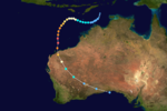
Severe Tropical Cyclone Orson was the fourth most intense cyclone
ever recorded in the Australian region. Forming out of a tropical low on 17 April 1989, Orson gradually intensified as it tracked towards the west. After attaining Category 5 intensity on 20 April, the storm began to track southward and accelerated. The following day, the cyclone reached its peak intensity with winds of 250 km/h (155 mph 10-minute sustained) and a barometric pressure of 904 hPa (mbar). Orson maintained this intensity for nearly two days before making landfall
near Dampier
. The cyclone rapidly weakened after landfall as it accelerated to the southeast. After moving into the Great Australian Bight
on 24 April, the storm dissipated.
Despite Orson's extreme intensity, damage was relatively minimal as it struck a sparsely populated region of Western Australia
. Five people were killed offshore and damages amounted to A$
(US$
. The storm damaged a new gas platform that explored a possible oil field, believed to contain nearly 200 million impgals (909,218 m³) of oil. The damage delayed the project for nearly two weeks. The most severe impacts took place in Pannawonica
, where 70 homes were damaged. Following the storm, clean up costs reached A$5 million (US$4.1 million). Due to the severity of the storm, the name Orson was retired after the season and replaced by Olga.
 Cyclone Orson originated out of a tropical low, monitored by the Australian Bureau of Meteorology, that formed northwest of Darwin, Australia
on 17 April 1989. The system tracked southwest throughout the day before turning due west and strengthening into a tropical cyclone
, at which time it received the name Orson. At this time, the Joint Typhoon Warning Center
(JTWC) also began monitoring the storm as Tropical Storm 28S. The forward motion of the storm gradually slowed as it intensified and on 19 April, Orson attained Category 3 status on the Australian tropical cyclone intensity scale, classifying Orson as a severe tropical cyclone. Later that day, as the storm attained Category 4 status, an eye
developed. By this time, Orson began to turn towards the southwest and on 20 April, the storm intensified into a Category 5 cyclone with winds of 210 km/h (130 mph 10-minute sustained).
The JTWC also reported significant strengthening during the same period. They assessed Orson to have attained an intensity equivalent to a Category 5 hurricane on the Saffir–Simpson Hurricane Scale on 22 April with winds of 260 km/h (160 mph 1-minute sustained). Around this time, the storm tracked directly over the North Rankin gas platform. The platform was in the 40 km (25 mi) wide eye of Orson for roughly 40 minutes. A weather station there recorded a barometric pressure of 904 hPa
(mbar
; 26.69 inHg) and wind gusts of 250 km/h (155 mph) before the station was damaged. This was, at the time, the lowest pressure ever recorded in the Australian region since records began. It was later surpassed by Severe Tropical Cyclone Gwenda in 1999
when that storm attained a pressure of 900 hPa (mbar). By this time, Cyclone Orson was roughly 555 km (345 mi) in diameter.
Continuing on a southerly track, accelerating ahead of an approaching cold front
, Cyclone Orson made landfall, near Dampier
, around 4:45 am AWST
on 23 April (2045 UTC 22 April). with winds of 220 km/h (140 mph 10-minute sustained). The JTWC also reported that Orson had weakened, with winds at landfall estimated at 230 km/h (145 mph 1-minute sustained). Tracking at 28 km/h (17 mph), the weakening storm passed over Pannawonica
. Less than 12 hours after landfall, the storm weakened below Category 3 status. By this time, the JTWC was no longer monitoring the system. Around 5:00 am AWST on 24 April (2100 UTC 23 April), Orson weakened to a tropical low while situated over southern Western Australia. Continuing to accelerate to nearly 50 km/h (31 mph), the remnants of the storm moved over the Great Australian Bight
late on 24 April. Several hours after moving back over water, the storm dissipated.
The Australian Bureau of Meteorology uses 10-minute sustained winds
, while the Joint Typhoon Warning Center uses one-minute sustained winds. The conversion factor between the two is 1.14. The Bureau of Meteorology's peak intensity for Orson was 250 km/h (155 mph) 10-minute sustained, or 290 km/h (180 mph) one-minute sustained. The JTWC's peak intensity for Orson was 260 km/h (160 mph) one-minute sustained, or 220 km/h (140 mph) 10-minute sustained.
On 23 April, a rescue mission with three aircraft recovered roughly 20 fisherman, while one was still missing. Offshore, the storm killed four fishermen after their ships sank in swells
up to 20 m (65.6 ft) produced by the storm. The North Rankin gas platform sustained minor damage despite wind gusts reaching 270 km/h (165 mph) and waves estimated at 21 m (68.9 ft). The large swells also delayed the find of a major oil field that contained more than 200 Moilbbl of oil. The waves knocked a drill rig used to find oil out of position; it would take several days for the drill rig to be repositioned. After an assessment of damage, it was found that the drill rig snapped off and broke the chains of two anchors before drifting nearly 2 km (1.2 mi) from the platform. The repositioning and cleanup of the drill rig delayed the project by nearly two weeks. The damages from Cyclone Orson increased the total cost of the platform to roughly A$
(US$
).
Upon making landfall, Orson produced a storm surge
of 3.1 m (10.2 ft). This came during low tide, having a height of 1.6 m (5.2 ft). Severe erosion was recorded along coastal areas, some losing nearly 20 m (65.6 ft) of rocks. Wind gusts in Dampier reached 183 km/h (113.7 mph) and a station near where Orson made landfall recorded a wind gust of 211 km/h (131.1 mph). Harbour officials stated that several ships were knocked off their moorings and washed up onshore. In Karratha
, the local weather radar
sustained roughly A$900,000 (US$760,000) in damages. A nearby airport was also damaged. The jetty at Point Samson
was severely damaged and eventually removed.
The most severe damage took place in the mining town of Pannawonica
, where 70 homes were damaged by the storm. Numerous trees and power lines were downed along the storm's path. Before dissipating, the storm left one additional person missing after contact was lost with his yacht. Later reports confirmed that the missing person drowned during the storm. Twenty people were also injured during the storm, 60 were left homeless and about 1,000 were affected. Total damages from the storm were estimated at A$20 million (US$16.8 million) and repair costs reached A$5 million (US$4.1 million). Due to the severity of the storm, the name Orson was retired after the season and replaced by Olga.
Tropical cyclone
A tropical cyclone is a storm system characterized by a large low-pressure center and numerous thunderstorms that produce strong winds and heavy rain. Tropical cyclones strengthen when water evaporated from the ocean is released as the saturated air rises, resulting in condensation of water vapor...
ever recorded in the Australian region. Forming out of a tropical low on 17 April 1989, Orson gradually intensified as it tracked towards the west. After attaining Category 5 intensity on 20 April, the storm began to track southward and accelerated. The following day, the cyclone reached its peak intensity with winds of 250 km/h (155 mph 10-minute sustained) and a barometric pressure of 904 hPa (mbar). Orson maintained this intensity for nearly two days before making landfall
Landfall (meteorology)
Landfall is the event of a tropical cyclone or a waterspout coming onto land after being over water. When a waterspout makes landfall it is reclassified as a tornado, which can then cause damage inland...
near Dampier
Dampier, Western Australia
Dampier is a major industrial port in the north-west of Western Australia. The Dampier Port is part of the Dampier Archipelago. The port services petrochemical, salt, iron ore and natural gas export industries. Rio Tinto exports large volumes of iron ore through the port, and in September 2010...
. The cyclone rapidly weakened after landfall as it accelerated to the southeast. After moving into the Great Australian Bight
Great Australian Bight
The Great Australian Bight is a large bight, or open bay, off the central and western portions of the southern coastline of mainland Australia.-Extent:...
on 24 April, the storm dissipated.
Despite Orson's extreme intensity, damage was relatively minimal as it struck a sparsely populated region of Western Australia
Western Australia
Western Australia is a state of Australia, occupying the entire western third of the Australian continent. It is bounded by the Indian Ocean to the north and west, the Great Australian Bight and Indian Ocean to the south, the Northern Territory to the north-east and South Australia to the south-east...
. Five people were killed offshore and damages amounted to A$
Australian dollar
The Australian dollar is the currency of the Commonwealth of Australia, including Christmas Island, Cocos Islands, and Norfolk Island, as well as the independent Pacific Island states of Kiribati, Nauru and Tuvalu...
(US$
United States dollar
The United States dollar , also referred to as the American dollar, is the official currency of the United States of America. It is divided into 100 smaller units called cents or pennies....
. The storm damaged a new gas platform that explored a possible oil field, believed to contain nearly 200 million impgals (909,218 m³) of oil. The damage delayed the project for nearly two weeks. The most severe impacts took place in Pannawonica
Pannawonica, Western Australia
The town of Pannawonica is an iron-ore mining town located in the Pilbara region of Western Australia, near the Robe River, about 200 km south-west from Karratha...
, where 70 homes were damaged. Following the storm, clean up costs reached A$5 million (US$4.1 million). Due to the severity of the storm, the name Orson was retired after the season and replaced by Olga.
Meteorological history
Darwin, Northern Territory
Darwin is the capital city of the Northern Territory, Australia. Situated on the Timor Sea, Darwin has a population of 127,500, making it by far the largest and most populated city in the sparsely populated Northern Territory, but the least populous of all Australia's capital cities...
on 17 April 1989. The system tracked southwest throughout the day before turning due west and strengthening into a tropical cyclone
Tropical cyclone
A tropical cyclone is a storm system characterized by a large low-pressure center and numerous thunderstorms that produce strong winds and heavy rain. Tropical cyclones strengthen when water evaporated from the ocean is released as the saturated air rises, resulting in condensation of water vapor...
, at which time it received the name Orson. At this time, the Joint Typhoon Warning Center
Joint Typhoon Warning Center
The Joint Typhoon Warning Center is a joint United States Navy – United States Air Force task force located at the Naval Maritime Forecast Center in Pearl Harbor, Hawaii...
(JTWC) also began monitoring the storm as Tropical Storm 28S. The forward motion of the storm gradually slowed as it intensified and on 19 April, Orson attained Category 3 status on the Australian tropical cyclone intensity scale, classifying Orson as a severe tropical cyclone. Later that day, as the storm attained Category 4 status, an eye
Eye (cyclone)
The eye is a region of mostly calm weather found at the center of strong tropical cyclones. The eye of a storm is a roughly circular area and typically 30–65 km in diameter. It is surrounded by the eyewall, a ring of towering thunderstorms where the second most severe weather of a cyclone...
developed. By this time, Orson began to turn towards the southwest and on 20 April, the storm intensified into a Category 5 cyclone with winds of 210 km/h (130 mph 10-minute sustained).
The JTWC also reported significant strengthening during the same period. They assessed Orson to have attained an intensity equivalent to a Category 5 hurricane on the Saffir–Simpson Hurricane Scale on 22 April with winds of 260 km/h (160 mph 1-minute sustained). Around this time, the storm tracked directly over the North Rankin gas platform. The platform was in the 40 km (25 mi) wide eye of Orson for roughly 40 minutes. A weather station there recorded a barometric pressure of 904 hPa
Pascal (unit)
The pascal is the SI derived unit of pressure, internal pressure, stress, Young's modulus and tensile strength, named after the French mathematician, physicist, inventor, writer, and philosopher Blaise Pascal. It is a measure of force per unit area, defined as one newton per square metre...
(mbar
Bar (unit)
The bar is a unit of pressure equal to 100 kilopascals, and roughly equal to the atmospheric pressure on Earth at sea level. Other units derived from the bar are the megabar , kilobar , decibar , centibar , and millibar...
; 26.69 inHg) and wind gusts of 250 km/h (155 mph) before the station was damaged. This was, at the time, the lowest pressure ever recorded in the Australian region since records began. It was later surpassed by Severe Tropical Cyclone Gwenda in 1999
1998–99 Australian region cyclone season
The 1998–99 Australian region cyclone season was an event in the ongoing cycle of tropical cyclone formation. It began on 1 November 1998 and ended on 30 April 1999...
when that storm attained a pressure of 900 hPa (mbar). By this time, Cyclone Orson was roughly 555 km (345 mi) in diameter.
Continuing on a southerly track, accelerating ahead of an approaching cold front
Weather front
A weather front is a boundary separating two masses of air of different densities, and is the principal cause of meteorological phenomena. In surface weather analyses, fronts are depicted using various colored lines and symbols, depending on the type of front...
, Cyclone Orson made landfall, near Dampier
Dampier, Western Australia
Dampier is a major industrial port in the north-west of Western Australia. The Dampier Port is part of the Dampier Archipelago. The port services petrochemical, salt, iron ore and natural gas export industries. Rio Tinto exports large volumes of iron ore through the port, and in September 2010...
, around 4:45 am AWST
Time in Australia
Australia uses Standard time, i.e: the same well defined time for a region. The proper names of Australia's time zones are Australian Western Standard Time , Australian Central Standard Time , and Australian Eastern Standard Time...
on 23 April (2045 UTC 22 April). with winds of 220 km/h (140 mph 10-minute sustained). The JTWC also reported that Orson had weakened, with winds at landfall estimated at 230 km/h (145 mph 1-minute sustained). Tracking at 28 km/h (17 mph), the weakening storm passed over Pannawonica
Pannawonica, Western Australia
The town of Pannawonica is an iron-ore mining town located in the Pilbara region of Western Australia, near the Robe River, about 200 km south-west from Karratha...
. Less than 12 hours after landfall, the storm weakened below Category 3 status. By this time, the JTWC was no longer monitoring the system. Around 5:00 am AWST on 24 April (2100 UTC 23 April), Orson weakened to a tropical low while situated over southern Western Australia. Continuing to accelerate to nearly 50 km/h (31 mph), the remnants of the storm moved over the Great Australian Bight
Great Australian Bight
The Great Australian Bight is a large bight, or open bay, off the central and western portions of the southern coastline of mainland Australia.-Extent:...
late on 24 April. Several hours after moving back over water, the storm dissipated.
The Australian Bureau of Meteorology uses 10-minute sustained winds
Maximum sustained wind
The maximum sustained winds associated with a tropical cyclone are a common indicator of the intensity of the storm. Within a mature tropical cyclone, they are found within the eyewall at a distance defined as the radius of maximum wind, or RMW. Unlike gusts, the value of these winds are...
, while the Joint Typhoon Warning Center uses one-minute sustained winds. The conversion factor between the two is 1.14. The Bureau of Meteorology's peak intensity for Orson was 250 km/h (155 mph) 10-minute sustained, or 290 km/h (180 mph) one-minute sustained. The JTWC's peak intensity for Orson was 260 km/h (160 mph) one-minute sustained, or 220 km/h (140 mph) 10-minute sustained.
Preparations and impact
As Cyclone Orson approached the coast of Western Australia, residents were urged to prepare for the storm; people proceeded to cleanup litter, secure outdoor items and make sure their disaster kits were stocked. All 200 personnel from a A$1.5 billion gas platform off the coast were evacuated ahead of the storm. Since Cyclone Orson made landfall in a sparsely populated region, its effects were relatively light compared to its intensity. More than 20 fishermen were reported missing during the storm.On 23 April, a rescue mission with three aircraft recovered roughly 20 fisherman, while one was still missing. Offshore, the storm killed four fishermen after their ships sank in swells
Swell (ocean)
A swell, in the context of an ocean, sea or lake, is a series surface gravity waves that is not generated by the local wind. Swell waves often have a long wavelength but this varies with the size of the water body, e.g. rarely more than 150 m in the Mediterranean, and from event to event, with...
up to 20 m (65.6 ft) produced by the storm. The North Rankin gas platform sustained minor damage despite wind gusts reaching 270 km/h (165 mph) and waves estimated at 21 m (68.9 ft). The large swells also delayed the find of a major oil field that contained more than 200 Moilbbl of oil. The waves knocked a drill rig used to find oil out of position; it would take several days for the drill rig to be repositioned. After an assessment of damage, it was found that the drill rig snapped off and broke the chains of two anchors before drifting nearly 2 km (1.2 mi) from the platform. The repositioning and cleanup of the drill rig delayed the project by nearly two weeks. The damages from Cyclone Orson increased the total cost of the platform to roughly A$
Australian dollar
The Australian dollar is the currency of the Commonwealth of Australia, including Christmas Island, Cocos Islands, and Norfolk Island, as well as the independent Pacific Island states of Kiribati, Nauru and Tuvalu...
(US$
United States dollar
The United States dollar , also referred to as the American dollar, is the official currency of the United States of America. It is divided into 100 smaller units called cents or pennies....
).
Upon making landfall, Orson produced a storm surge
Storm surge
A storm surge is an offshore rise of water associated with a low pressure weather system, typically tropical cyclones and strong extratropical cyclones. Storm surges are caused primarily by high winds pushing on the ocean's surface. The wind causes the water to pile up higher than the ordinary sea...
of 3.1 m (10.2 ft). This came during low tide, having a height of 1.6 m (5.2 ft). Severe erosion was recorded along coastal areas, some losing nearly 20 m (65.6 ft) of rocks. Wind gusts in Dampier reached 183 km/h (113.7 mph) and a station near where Orson made landfall recorded a wind gust of 211 km/h (131.1 mph). Harbour officials stated that several ships were knocked off their moorings and washed up onshore. In Karratha
Karratha, Western Australia
-Facilities:A range of hotel, motel, B&B and caravan/RV accommodation is available for visitors. However, as the town is booming, accommodation is often hard to come by.The town has restaurants, a tavern, two hotels and two night clubs...
, the local weather radar
Weather radar
Weather radar, also called weather surveillance radar and Doppler weather radar, is a type of radar used to locate precipitation, calculate its motion, estimate its type . Modern weather radars are mostly pulse-Doppler radars, capable of detecting the motion of rain droplets in addition to the...
sustained roughly A$900,000 (US$760,000) in damages. A nearby airport was also damaged. The jetty at Point Samson
Point Samson, Western Australia
,Point Samson is a small coastal hamlet 1,579 km north of Perth and 18 km north of Roebourne in the Pilbara region of Western Australia. The town is a popular holiday location for the nearby mining towns, including Wickham, Karratha and Dampier. Fishing is the main industry...
was severely damaged and eventually removed.
The most severe damage took place in the mining town of Pannawonica
Pannawonica, Western Australia
The town of Pannawonica is an iron-ore mining town located in the Pilbara region of Western Australia, near the Robe River, about 200 km south-west from Karratha...
, where 70 homes were damaged by the storm. Numerous trees and power lines were downed along the storm's path. Before dissipating, the storm left one additional person missing after contact was lost with his yacht. Later reports confirmed that the missing person drowned during the storm. Twenty people were also injured during the storm, 60 were left homeless and about 1,000 were affected. Total damages from the storm were estimated at A$20 million (US$16.8 million) and repair costs reached A$5 million (US$4.1 million). Due to the severity of the storm, the name Orson was retired after the season and replaced by Olga.
See also
- 1985–90 Southern Hemisphere tropical cyclone seasons
- List of cyclones in Western Australia
- List of most intense tropical cyclones
External links
- Australian Bureau of Meteorology (TCWC's Perth, Darwin & Brisbane)
- Joint Typhoon Warning Center (JTWC)
- Track of Cyclone Orson (provided by Australia Severe Weather)