
Croker Island
Encyclopedia
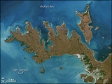
Croker Island is an island
in the Arafura Sea
off the coast of the Northern Territory
, Australia
, 200 km northeast of Darwin
. It is separated from Cobourg Peninsula
in the west by Bowen Strait, which is 2.5 km wide in the south and up to 7 km in the north, and 8.5 km long. In the north and east is the Arafura Sea
, and in the south and southeast Mountnorris Bay. Croker Island measures 43 km from Point David (south, local name Inngirnatj) to Cape Croker (north), up to 15 km wide, and has an area of 331.5 km² (128.0 sq. miles). At its highest point it is only 15 m (50 feet) above sea level. The only notable settlement on Croker Island is the Aboriginal community of Minjilang
, located on Mission Bay on the east coast. Apart from that, there are nine small family outstation
s, the largest ones of which is Inngirnatj (Point David) at the southern end of the island. The settlements from north to south:
The traditional owners of Croker Island, the Yarmirr People, filed the Croker Island Sea Claim. The case, Yarmirr v Northern Territory
, was settled in the High Court of Australia
on 11 October 2001. The case established that traditional owners do have native title
of the sea and sea-bed, however common law rights of fishing and navigation mean that only non-exclusive native title can exist over the sea.
The Island was severely damaged by Cyclone Ingrid
in March 2005.
Island
An island or isle is any piece of sub-continental land that is surrounded by water. Very small islands such as emergent land features on atolls can be called islets, cays or keys. An island in a river or lake may be called an eyot , or holm...
in the Arafura Sea
Arafura Sea
The Arafura Sea lies west of the Pacific Ocean overlying the continental shelf between Australia and New Guinea.-Geography:The Arafura Sea is bordered by Torres Strait and through that the Coral Sea to the east, the Gulf of Carpentaria to the south, the Timor Sea to the west and the Banda and Ceram...
off the coast of the Northern Territory
Northern Territory
The Northern Territory is a federal territory of Australia, occupying much of the centre of the mainland continent, as well as the central northern regions...
, Australia
Australia
Australia , officially the Commonwealth of Australia, is a country in the Southern Hemisphere comprising the mainland of the Australian continent, the island of Tasmania, and numerous smaller islands in the Indian and Pacific Oceans. It is the world's sixth-largest country by total area...
, 200 km northeast of Darwin
Darwin, Northern Territory
Darwin is the capital city of the Northern Territory, Australia. Situated on the Timor Sea, Darwin has a population of 127,500, making it by far the largest and most populated city in the sparsely populated Northern Territory, but the least populous of all Australia's capital cities...
. It is separated from Cobourg Peninsula
Cobourg Peninsula
The Cobourg Peninsula is located 350 kilometres east of Darwin in the Northern Territory, Australia. It is deeply indented with coves and bays, covers a land area of about 2,100 km², and is virtually uninhabited with a population ranging from about 20 to 30 in five family outstations, but...
in the west by Bowen Strait, which is 2.5 km wide in the south and up to 7 km in the north, and 8.5 km long. In the north and east is the Arafura Sea
Arafura Sea
The Arafura Sea lies west of the Pacific Ocean overlying the continental shelf between Australia and New Guinea.-Geography:The Arafura Sea is bordered by Torres Strait and through that the Coral Sea to the east, the Gulf of Carpentaria to the south, the Timor Sea to the west and the Banda and Ceram...
, and in the south and southeast Mountnorris Bay. Croker Island measures 43 km from Point David (south, local name Inngirnatj) to Cape Croker (north), up to 15 km wide, and has an area of 331.5 km² (128.0 sq. miles). At its highest point it is only 15 m (50 feet) above sea level. The only notable settlement on Croker Island is the Aboriginal community of Minjilang
Minjilang, Northern Territory
Minjilang, formerly Mission Bay, is the Aboriginal community located on Croker Island, some 235 km east northeast of Northern Territory's capital of Darwin. It is the only settlement of any size on Croker Island . The island is just a few kilometres from Cobourg Peninsula on the mainland...
, located on Mission Bay on the east coast. Apart from that, there are nine small family outstation
Outstation
Historically, an outstation was a subsidiary homestead or other dwelling, on Australian sheep or cattle stations which were large enough to have more than a day's travel between different parts of the property....
s, the largest ones of which is Inngirnatj (Point David) at the southern end of the island. The settlements from north to south:
- Alamirra (close to Somerville Bay 1.5 km further the north)
- Timor Springs (north of Minjilang, 8 km by road)
- Wanakutja (on Palm Bay in the northwest)
- MinjilangMinjilang, Northern TerritoryMinjilang, formerly Mission Bay, is the Aboriginal community located on Croker Island, some 235 km east northeast of Northern Territory's capital of Darwin. It is the only settlement of any size on Croker Island . The island is just a few kilometres from Cobourg Peninsula on the mainland...
(Mission Bay), the only village and main settlement of the island - Adjamarrago (800 meters north of Croker Island Aerodrome, west of Minjilang)
- Keith William's Outstation (Arrgamumu, Arrgamurrmur) (southeast of Mission Bay)
- Walka (Barge Landing) (south side of Mission Bay, with barge pier)
- Sandy Bay (close to Sandy Bay on the east coast, but two kilometers to the coast)
- Marramarrani (southwest coast)
- Inngirnatj (Point David) (southern end, west side, with boat pier)
The traditional owners of Croker Island, the Yarmirr People, filed the Croker Island Sea Claim. The case, Yarmirr v Northern Territory
Yarmirr v Northern Territory
Yarmirr v Northern Territory, [2001] HCA 56, was an application for the determination of native title to seas, sea-bed and sub-soil, appealed to the High Court of Australia.-Application:...
, was settled in the High Court of Australia
High Court of Australia
The High Court of Australia is the supreme court in the Australian court hierarchy and the final court of appeal in Australia. It has both original and appellate jurisdiction, has the power of judicial review over laws passed by the Parliament of Australia and the parliaments of the States, and...
on 11 October 2001. The case established that traditional owners do have native title
Native title
Native title is the Australian version of the common law doctrine of aboriginal title.Native title is "the recognition by Australian law that some Indigenous people have rights and interests to their land that come from their traditional laws and customs"...
of the sea and sea-bed, however common law rights of fishing and navigation mean that only non-exclusive native title can exist over the sea.
The Island was severely damaged by Cyclone Ingrid
Cyclone Ingrid
Cyclone Ingrid was a tropical cyclone which struck northern Australia during the 2004-05 Australian region cyclone season. Its minimum pressure was 924 mbar .-Meteorological history:Ingrid developed in the Coral Sea on 3 March 2005...
in March 2005.