

Culbertson's Path
Encyclopedia
Native Americans in the United States
Native Americans in the United States are the indigenous peoples in North America within the boundaries of the present-day continental United States, parts of Alaska, and the island state of Hawaii. They are composed of numerous, distinct tribes, states, and ethnic groups, many of which survive as...
trail
Trail
A trail is a path with a rough beaten or dirt/stone surface used for travel. Trails may be for use only by walkers and in some places are the main access route to remote settlements...
in north central Pennsylvania
Pennsylvania
The Commonwealth of Pennsylvania is a U.S. state that is located in the Northeastern and Mid-Atlantic regions of the United States. The state borders Delaware and Maryland to the south, West Virginia to the southwest, Ohio to the west, New York and Ontario, Canada, to the north, and New Jersey to...
in the United States
United States
The United States of America is a federal constitutional republic comprising fifty states and a federal district...
, which connected the Great Island Path
Great Island Path
The Great Island Path was a major Native American trail in the U.S. State of Pennsylvania that ran from the village of Shamokin along the right bank of the West Branch Susquehanna River north and then west to the Great Island .The village of Shamokin was just south of the "forks of the...
with the Sheshequin Path
Sheshequin Path
The Sheshequin Path was a major Native American trail in the U.S. State of Pennsylvania that ran between two Native American villages: "French Margaret's Town" on the West Branch Susquehanna River and "Sheshequin" on the North Branch of the Susquehanna River...
. The eastern / southern end of the path was on the West Branch Susquehanna River
West Branch Susquehanna River
The West Branch Susquehanna River is one of the two principal branches, along with the North Branch, of the Susquehanna River in the northeastern United States. The North Branch, which rises in upstate New York, is generally regarded as the extension of the main branch, with the shorter West Branch...
at what is now the unincorporated
Unincorporated area
In law, an unincorporated area is a region of land that is not a part of any municipality.To "incorporate" in this context means to form a municipal corporation, a city, town, or village with its own government. An unincorporated community is usually not subject to or taxed by a municipal government...
village
Village
A village is a clustered human settlement or community, larger than a hamlet with the population ranging from a few hundred to a few thousand , Though often located in rural areas, the term urban village is also applied to certain urban neighbourhoods, such as the West Village in Manhattan, New...
of Allenwood in Gregg Township
Gregg Township, Union County, Pennsylvania
Gregg Township is a township in Union County, Pennsylvania, United States. The population was 4,687 at the 2000 census, .-History:Gregg Township, named for U.S...
in Union County
Union County, Pennsylvania
-Demographics:As of the census of 2000, there were 41,624 people, 13,178 households, and 9,211 families residing in the county. The population density was 131 people per square mile . There were 14,684 housing units at an average density of 46 per square mile...
. The northern / western end was in Old Lycoming Township
Old Lycoming Township, Pennsylvania
Old Lycoming Township is a township in Lycoming County, Pennsylvania, in the United States. The population was 5,508 at the 2000 census. It is part of the Williamsport, Pennsylvania Metropolitan Statistical Area.-History:...
just north of what is now the city of Williamsport
Williamsport, Pennsylvania
Williamsport is a city in and the county seat of Lycoming County, Pennsylvania in the United States. In 2009, the population was estimated at 29,304...
in Lycoming County
Lycoming County, Pennsylvania
-Appalachian Mountains and Allegheny Plateau:Lycoming County is divided between the Appalachian Mountains in the south, the dissected Allegheny Plateau in the north and east, and the valley of the West Branch Susquehanna River between these.-West Branch Susquehanna River:The West Branch of the...
.
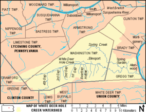
Culbertson's Path followed White Deer Hole Creek
White Deer Hole Creek
White Deer Hole Creek is a tributary of the West Branch Susquehanna River in Clinton, Lycoming and Union counties in the U.S. state of Pennsylvania. A part of the Chesapeake Bay drainage basin, the White Deer Hole Creek watershed drains parts of ten townships...
west from Allenwood, then left to follow Spring Creek north, crossing North White Deer Ridge and Bald Eagle Mountain
Bald Eagle Mountain
Bald Eagle Mountain, once known locally as Muncy Mountain, is a stratigraphic ridge in central Pennsylvania, United States, running east of the Allegheny Front and northwest of Mount Nittany. It lies along the southeast side of Bald Eagle Creek, and south of the West Branch Susquehanna River, and...
and following Mosquito Run to the West Branch Susquehanna River at the modern borough of Duboistown
Duboistown, Pennsylvania
Duboistown is a borough in Lycoming County, Pennsylvania, United States. The population was 1,280 at the 2000 census. It is part of the Williamsport, Pennsylvania Metropolitan Statistical Area.-History:...
. Here it forded
Ford (crossing)
A ford is a shallow place with good footing where a river or stream may be crossed by wading or in a vehicle. A ford is mostly a natural phenomenon, in contrast to a low water crossing, which is an artificial bridge that allows crossing a river or stream when water is low.The names of many towns...
the river at Culbertson's Ripples (approximately the modern location of the Arch Street Bridge). From Allenwood to Spring Creek, Culbertson's Path and the Great Island Path
Great Island Path
The Great Island Path was a major Native American trail in the U.S. State of Pennsylvania that ran from the village of Shamokin along the right bank of the West Branch Susquehanna River north and then west to the Great Island .The village of Shamokin was just south of the "forks of the...
shared the same trail. The Great Island Path led west to the Great Island (modern Lock Haven
Lock Haven, Pennsylvania
The city of Lock Haven is the county seat of Clinton County, in the U.S. state of Pennsylvania. Located near the confluence of the West Branch Susquehanna River and Bald Eagle Creek, it is the principal city of the Lock Haven, Pennsylvania, micropolitan statistical area, itself part of the...
) and paths there led west to the Allegheny River
Allegheny River
The Allegheny River is a principal tributary of the Ohio River; it is located in the Eastern United States. The Allegheny River joins with the Monongahela River to form the Ohio River at the "Point" of Point State Park in Downtown Pittsburgh, Pennsylvania...
and beyond.
After fording the river, Culbertson's Path crossed the Great Shamokin Path
Great Shamokin Path
The Great Shamokin Path was a major Native American trail in the U.S. State of Pennsylvania that ran from the native village of Shamokin along the left bank of the West Branch Susquehanna River north and then west to the Great Island...
(which also led west to the Great Island and beyond) to the village named "French Margaret's Town" on the west bank of Lycoming Creek
Lycoming Creek
Lycoming Creek is a tributary of the West Branch Susquehanna River located in Tioga and Lycoming counties in Pennsylvania in the United States.-Geography:...
(modern Williamsport). Culbertson's Path then continued north to modern Old Lycoming Township, where it joined the major Sheshequin Path
Sheshequin Path
The Sheshequin Path was a major Native American trail in the U.S. State of Pennsylvania that ran between two Native American villages: "French Margaret's Town" on the West Branch Susquehanna River and "Sheshequin" on the North Branch of the Susquehanna River...
, which lead north up Lycoming Creek towards the North Branch of the Susquehanna River
Susquehanna River
The Susquehanna River is a river located in the northeastern United States. At long, it is the longest river on the American east coast that drains into the Atlantic Ocean, and with its watershed it is the 16th largest river in the United States, and the longest river in the continental United...
, modern New York
New York
New York is a state in the Northeastern region of the United States. It is the nation's third most populous state. New York is bordered by New Jersey and Pennsylvania to the south, and by Connecticut, Massachusetts and Vermont to the east...
, and the Iroquois
Iroquois
The Iroquois , also known as the Haudenosaunee or the "People of the Longhouse", are an association of several tribes of indigenous people of North America...
there.
South of Allenwood, there were connections via the Great Island Path to the village of Shamokin
Shamokin (village)
Shamokin was a multi-ethnic Native American trading village on the Susquehanna River, located near the site of the modern Sunbury, Pennsylvania. Early in the eighteenth century, the village consisted of Iroquois migrants from the north, as well as Shawnee and Lenape settlers moving away from the...
(modern Sunbury
Sunbury, Pennsylvania
Sunbury is a city in Northumberland County, Pennsylvania, United States. The city is located on the east bank of the Susquehanna River, just downstream of the confluence of its main and West branches. The population was 9,905 at the 2010 census...
), as well as the Virginia Road and the Penns Creek and Mahanoy Paths.
The path was only wide enough for one person, but the early inhabitants of White Deer Hole valley broadened the trail to DuBoistown to take grain to Culbertson's mill on Mosquito Run (leading them to call it "Culbertson's path"). In 2006, there is still a "Culbertson's Trail", for hiking over North White Deer Ridge and Bald Eagle Mountain from Pennsylvania Route 554
Pennsylvania Route 554
Pennsylvania Route 554 is a highway which runs for 8 miles generally north–south in Lycoming County in north central Pennsylvania in the United States. Its southern terminus is at Pennsylvania Route 44 just north of the unincorporated village of Elimsport in Washington Township and its...
to Duboistown.