
Cox's Bazar District
Encyclopedia
Cox's Bazar District is a district in the Chittagong Division of Bangladesh
. It is named after Cox's Bazar
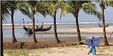
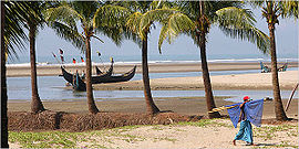
, which is one of the world's longest natural sea beaches (120 kilometres (74.6 mi) including mud flats). It is located 150 kilometres (93.2 mi) south of Chittagong
. Cox's Bazar is also known by the name Panowa ("yellow flower"). Another old name was Palongkee. The modern Cox's Bazar derives its name from Captain Cox (died 1798), an army officer who served in British India
. It is one of the fishing ports of Bangladesh.
Cox's Bazar District has an area of 2491.86 km². It is located at 21°35′0"N 92°01′0"E and is bounded by Chittagong District
on the north, Bay of Bengal
in the south, Bandarban District
on the east, and the Bay of Bengal
on the west. Major rivers include Matamuhuri, Bakkhali
, Reju Khal, Naf River
, Maheshkhali channel and Kutubdia channel. The area of the city of Cox's Bazar is 6.85 km².
period. On his way to Arakan
, when the Mughal Prince Shah Shuja (1616–1660) passed through the hilly terrain of the present day Cox’s Bazar, he was attracted to the scenic and captivating beauty of the region. He commanded his forces to camp there. A place named Dulahazara, meaning "one thousand palanquins", still exists in the area.
After the Mughals, the place came under the control of the Tipras and the Arakanese, followed by the Portuguese
and then the British
.
The name Cox's Bazar/Bazaar derived from the name of Captain James Cox of the East India, who was in charge of the naval base. In 1854, Cox's Bazar was made a subdivisional headquarters.
After the end of British rule, Cox's Bazar remained part of East Pakistan
. Captain Advocate Fazlul Karim was the first chairman after independence from the British of Cox's Bazar municipality. He established the Tamarisk Forest along the beach to draw tourism to the town and to protect the beach from the tide. He donated many of his father-in-law's and his own lands to establish a public library and town hall. In 1971, the wharf was used as a naval port by the Pakistan Navy
's gunboats. This and the nearby airstrip of the Pakistan Air Force
were the scene of intense shelling by the Indian Navy
during the Bangladesh Liberation War
in 1971.
In 1984 Cox's Bazar was made a District
.
 There are eight upazilas
under this district, namely:
The population of Cox's Bazar includes Muslims, Hindus and Buddhists.
A number of people are involved in the fishing and collection of seafoods and sea products. Oysters, snails, searls and jewelry made from shells are popular with the tourists in the seaside and city stores. A number of people are also involved in the transportation business for tourists. Many people of the district are farmers.
In 2002, a surfing club was initiated at Cox's Bazar by a local Bangladeshi. It has now extended to holding an annual competition including locals and foreign tourists. This is the first surfing initiative in Bangladesh's history.
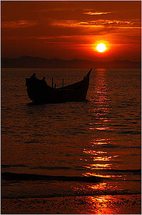 Cox’s Bazar, mostly famous for its beautiful sea beach and the sunset, has several other attractions, including:
Bangladesh
Bangladesh , officially the People's Republic of Bangladesh is a sovereign state located in South Asia. It is bordered by India on all sides except for a small border with Burma to the far southeast and by the Bay of Bengal to the south...
. It is named after Cox's Bazar
Cox's Bazar
Cox's Bazar is a town, a fishing port and district headquarters in Bangladesh. It is known for its wide sandy beach which is the world's longest natural sandy sea beach. It is an unbroken 125 km sandy sea beach with a gentle slope. It is located 150 km south of Chittagong. Cox’s Bazar...
, which is one of the world's longest natural sea beaches (120 kilometres (74.6 mi) including mud flats). It is located 150 kilometres (93.2 mi) south of Chittagong
Chittagong
Chittagong ) is a city in southeastern Bangladesh and the capital of an eponymous district and division. Built on the banks of the Karnaphuli River, the city is home to Bangladesh's busiest seaport and has a population of over 4.5 million, making it the second largest city in the country.A trading...
. Cox's Bazar is also known by the name Panowa ("yellow flower"). Another old name was Palongkee. The modern Cox's Bazar derives its name from Captain Cox (died 1798), an army officer who served in British India
British Raj
British Raj was the British rule in the Indian subcontinent between 1858 and 1947; The term can also refer to the period of dominion...
. It is one of the fishing ports of Bangladesh.
Geography
Often termed as the world's longest beach, Cox's Bazar has yet to become a major tourist destination in Asia.Cox's Bazar District has an area of 2491.86 km². It is located at 21°35′0"N 92°01′0"E and is bounded by Chittagong District
Chittagong District
Chittagong District is a district located in the south-eastern region of Bangladesh. It is a part of the Chittagong Division. The port city of Chittagong, second largest city in Bangladesh, is located in this district.-History:...
on the north, Bay of Bengal
Bay of Bengal
The Bay of Bengal , the largest bay in the world, forms the northeastern part of the Indian Ocean. It resembles a triangle in shape, and is bordered mostly by the Eastern Coast of India, southern coast of Bangladesh and Sri Lanka to the west and Burma and the Andaman and Nicobar Islands to the...
in the south, Bandarban District
Bandarban District
Bandarban is a district in South-Eastern Bangladesh, and a part of the Chittagong Division and Chittagong Hill Tracts. Bandarban , or in Marma or Arakanese language as "Rwa-daw Mro" is also known as Arvumi or the Bohmong Circle Bandarban is a district in South-Eastern Bangladesh, and a part of...
on the east, and the Bay of Bengal
Bay of Bengal
The Bay of Bengal , the largest bay in the world, forms the northeastern part of the Indian Ocean. It resembles a triangle in shape, and is bordered mostly by the Eastern Coast of India, southern coast of Bangladesh and Sri Lanka to the west and Burma and the Andaman and Nicobar Islands to the...
on the west. Major rivers include Matamuhuri, Bakkhali
Bakkhali
Bakkhali is seaside resort in South 24 Parganas district of West Bengal, India. It is located on one of the many deltaic islands spread across southern Bengal. Most of the islands are part of the Sunderbans, barring a few at the fringes. Some of these are joined together with bridges over narrow...
, Reju Khal, Naf River
Naf River
Naf River It is an elongated estuary in the extreme southeast of Cox's Bazar district dividing the district from Arakan, Myanmar. It rises in the Arakan hills on the southeastern borders of the district and flows into the Bay of Bengal. Its width varies from 1.61 km to 3.22 km. The river...
, Maheshkhali channel and Kutubdia channel. The area of the city of Cox's Bazar is 6.85 km².
History
The history of Cox's Bazar begins in the MughalMughal Empire
The Mughal Empire , or Mogul Empire in traditional English usage, was an imperial power from the Indian Subcontinent. The Mughal emperors were descendants of the Timurids...
period. On his way to Arakan
Rakhine State
Rakhine State is a Burmese state. Situated on the western coast, it is bordered by Chin State in the north, Magway Region, Bago Region and Ayeyarwady Region in the east, the Bay of Bengal to the west, and the Chittagong Division of Bangladesh to the northwest. It is located approximately between...
, when the Mughal Prince Shah Shuja (1616–1660) passed through the hilly terrain of the present day Cox’s Bazar, he was attracted to the scenic and captivating beauty of the region. He commanded his forces to camp there. A place named Dulahazara, meaning "one thousand palanquins", still exists in the area.
After the Mughals, the place came under the control of the Tipras and the Arakanese, followed by the Portuguese
Portugal
Portugal , officially the Portuguese Republic is a country situated in southwestern Europe on the Iberian Peninsula. Portugal is the westernmost country of Europe, and is bordered by the Atlantic Ocean to the West and South and by Spain to the North and East. The Atlantic archipelagos of the...
and then the British
British Empire
The British Empire comprised the dominions, colonies, protectorates, mandates and other territories ruled or administered by the United Kingdom. It originated with the overseas colonies and trading posts established by England in the late 16th and early 17th centuries. At its height, it was the...
.
The name Cox's Bazar/Bazaar derived from the name of Captain James Cox of the East India, who was in charge of the naval base. In 1854, Cox's Bazar was made a subdivisional headquarters.
After the end of British rule, Cox's Bazar remained part of East Pakistan
East Pakistan
East Pakistan was a provincial state of Pakistan established in 14 August 1947. The provincial state existed until its declaration of independence on 26 March 1971 as the independent nation of Bangladesh. Pakistan recognized the new nation on 16 December 1971. East Pakistan was created from Bengal...
. Captain Advocate Fazlul Karim was the first chairman after independence from the British of Cox's Bazar municipality. He established the Tamarisk Forest along the beach to draw tourism to the town and to protect the beach from the tide. He donated many of his father-in-law's and his own lands to establish a public library and town hall. In 1971, the wharf was used as a naval port by the Pakistan Navy
Pakistan Navy
The Pakistan Navy is the naval warfare/service branch of the Pakistan Armed Forces. Pakistan's Navy is responsible for Pakistan's coastline along the Arabian Sea and the defense of important civilian harbors and military bases...
's gunboats. This and the nearby airstrip of the Pakistan Air Force
Pakistan Air Force
The Pakistan Air Force is the leading air arm of the Pakistan Armed Forces and is primarily tasked with the aerial defence of Pakistan with a secondary role of providing air support to the Pakistan Army and the Pakistan Navy. The PAF also has a tertiary role of providing strategic air transport...
were the scene of intense shelling by the Indian Navy
Indian Navy
The Indian Navy is the naval branch of the armed forces of India. The President of India serves as the Commander-in-Chief of the Navy. The Chief of Naval Staff , usually a four-star officer in the rank of Admiral, commands the Navy...
during the Bangladesh Liberation War
Bangladesh Liberation War
The Bangladesh Liberation War was an armed conflict pitting East Pakistan and India against West Pakistan. The war resulted in the secession of East Pakistan, which became the independent nation of Bangladesh....
in 1971.
In 1984 Cox's Bazar was made a District
Districts of Bangladesh
The divisions of Bangladesh are divided into 64 districts, or zila . The districts are further subdivided into 493 sub-districts, or upazila ....
.
Subdivisions
Upazilas of Bangladesh
||The districts of Bangladesh are divided into subdistricts called Upazila Parishad , or Thana . Upazilas are similar to the county subdivisions found in some Western countries....
under this district, namely:
- Chakaria UpazilaChakaria UpazilaChakaria is an Upazila of Cox's Bazar District in the Division of Chittagong, Bangladesh.-Geography:Chakoria is located at . It has 63671 units of house hold and total area 643.46 km².-Demographics:...
- Cox's Bazar Sadar UpazilaCox's Bazar Sadar UpazilaCox's Bazar Sadar is an Upazila of Cox's Bazar District in the Division of Chittagong, Bangladesh.-Geography:Cox's Bazar Sadar is located at . It has 38688 units of house hold and total area 228.23 km².-Demographics:...
- Kutubdia UpazilaKutubdia UpazilaKutubdia is an Upazila of Cox's Bazar District in the Division of Chittagong, Bangladesh. The upazila consists of an island in the Bay of Bengal, off the coast near Chakaria, Cox's Bazar.-Geography:...
- Maheshkhali UpazilaMaheshkhali UpazilaMaheshkhali is an Upazila of Cox's Bazar District in the Division of Chittagong, Bangladesh.-Geography:Maheshkhali is located at . It has 33287 units of house hold and total area 362.18 km².-Demographics:...
- Ramu UpazilaRamu UpazilaRamu is an Upazila of Cox's Bazar District in the Division of Chittagong, Bangladesh.-Geography:Ramu is located at . It has 26964 units of house hold and the area of the town is 22.03 km2.-Demographics:...
- Teknaf UpazilaTeknaf UpazilaTeknaf is an Upazila of Cox's Bazar District in the Division of Chittagong, Bangladesh. It forms the southernmost point in mainland Bangladesh . The name of the region comes from the Naf River which forms the Eastern boundary of the upazila.-Geography:Teknaf is located at...
- Ukhia UpazilaUkhia UpazilaUkhia is an Upazila of Cox's Bazar District in the Division of Chittagong, Bangladesh.-Geography:Ukhia is located at . It has 19189 units of house hold and total area 261.8 km².-Demographics:...
- Pekua Upazila
The population of Cox's Bazar includes Muslims, Hindus and Buddhists.
Climate
The annual average temperature in Cox's Bazar is 34.8 °C and a minimum of 16.1 °C. The climate remains hot and humid with some seasons of temperate weather. The average amount of rainfall is 4285 nm.Economy and development
The major livelihood of Cox's Bazar district is tourism. Millions of foreign and Bangladeshi natives visit this coastal city every year. A number of hotels, guest houses, and motels have been built in the city and coastal region and the hospitality industry is a major employer in the area.A number of people are involved in the fishing and collection of seafoods and sea products. Oysters, snails, searls and jewelry made from shells are popular with the tourists in the seaside and city stores. A number of people are also involved in the transportation business for tourists. Many people of the district are farmers.
In 2002, a surfing club was initiated at Cox's Bazar by a local Bangladeshi. It has now extended to holding an annual competition including locals and foreign tourists. This is the first surfing initiative in Bangladesh's history.
Religion
The district of Cox's Bazar consists 2300 mosques, 1200 Buddhist Temples, 700 churches and 400 temples.Places of interest
- Aggmeda Khyang, a large Buddhist monastery, and a place revered by around 400,000 Buddhist people of Cox's Bazar Hill Tracts.
- Himchari, located about 8 km south of Cox's Bazar, is a picnic spot famous for its waterfalls. Birds and animals roam near the road.
- Inani Beach has interesting rocks and coral boulders. It is 32 km from the main beach. There are no facilities so a packed lunch is required.
- Coxsbazar Circuit House, located 2 km from Laboni Point, has a good viewpoint. The ocean can be seen from a height, and one can also enjoy the view of Cox's Bazar city.
- St. Martin's IslandSt. Martin's IslandSt. Martin's Island is a small island in the northheast part of the Bay of Bengal, about 9 km south of the tip of the Cox's Bazar-Teknaf peninsula, and forming the southernmost part of Bangladesh. It is not a coral island in Bangladesh. It is about 8 km west of the northwest coast of...
, the only coral island in Bangladesh, is situated at 9 km south of Teknaf. It is a popular tourist spot.