

Districts of Bangladesh
Encyclopedia
The divisions
Divisions of Bangladesh
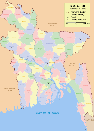
||Bangladesh is divided into seven major administrative regions called divisions . Each division is named after the major city within its jurisdiction that serves as the administrative capital of that division:...
of Bangladesh
Bangladesh
Bangladesh , officially the People's Republic of Bangladesh is a sovereign state located in South Asia. It is bordered by India on all sides except for a small border with Burma to the far southeast and by the Bay of Bengal to the south...
are divided into 64 districts, or zila . The districts are further subdivided into 493 sub-districts, or upazila
Upazilas of Bangladesh
||The districts of Bangladesh are divided into subdistricts called Upazila Parishad , or Thana . Upazilas are similar to the county subdivisions found in some Western countries....
(উপজেলা upojela).
The district are run by a Deputy Commissioner popular name is "DC" is appointed by the government from a Deputy secretary
Ministries of Bangladesh
The most influential part of the executive of the Bangladesh government are the ministries. A ministry is headed by minister or minister of state shall be responsible for conducting the business of his Ministry/Division in the Parliament unless otherwise directed by the Prime Minister...
of B.C.S.
Bangladesh Civil Service
Bangladesh Civil Service, more popularly known by its acronym BCS, is the elite civil service of the Government of Bangladesh. It originated from the Central Superior Services of Pakistan. Since independence it has been known by Act as Bangladesh Civil Service. The Bangladesh Public Service...
Administration Cadre.
The districts are listed below in alphabetical order by division. The official English name of each district is followed by the official Bengali name in parentheses, using both the Bengali script
Bengali script
The Bengali alphabet is the writing system for the Bengali language. The script with variations is used for Assamese and is basis for Meitei, Bishnupriya Manipuri, Kokborok, Garo and Mundari alphabets. All these languages are spoken in the eastern region of South Asia. Historically, the script has...
and Romanization adopted for Wikipedia:
Barisal (বরিশাল)Barisal DivisionBarisal Division is located in south-central Bangladesh, with an area of 13,644.85 km2, and with a population of 8,147,000 at the 2011 Census . It is bounded by Dhaka division on the north, the Bay of Bengal on the south, Chittagong division on the east and Khulna division on the west...
There are 6 Districts under Barisal Division. The districts are:- BargunaBarguna DistrictBarguna is a district in South-western Bangladesh. It is a part of the Barisal Division.-Geography:The Barguna District has a total area of 1831.31 km². It is bounded on the north by the districts of Jhalkathi, Barisal, Pirojpur and Patuakhali. In the east, it borders the Patuakhali District....
(বরগুনা) - BarisalBarisal DistrictBarisal is a district in southern Bangladesh. It is also the headquarters of Barisal Division.-Geography and climate:Latitude: 22.75, Longitude: 90.36, Altitude: 4....
(বরিশাল) - BholaBhola DistrictBhola is a district in south-western Bangladesh. It is located in the Barisal Division. It is also the largest offshore island region in Bangladesh, with an area of 3403.48 km²...
(ভোলা) - Jhalokati (ঝালকাঠি)
- PirojpurPirojpur DistrictPirojpur is a district in South-western Bangladesh. It is a part of the Barisal Division.-Name:Myth exist that, second son of Shah Shuja, Firoz Shah died in this area and in honour of him, the area started to being calld 'Firozpur'....
(পিরোজপুর) - PatuakhaliPatuakhali DistrictPatuakhali is a district in South-western Bangladesh. It is a part of the Barisal Division.This is the main entrance for the beach of Kuakata. Famous for watching both the sun rise and sun set. It is called "The Daughter of Sea".-Geography:...
(পটুয়াখালী)
Chittagong (চট্টগ্রাম)
There are 11 districts under Chittagong Division. The districts are:- BandarbanBandarban DistrictBandarban is a district in South-Eastern Bangladesh, and a part of the Chittagong Division and Chittagong Hill Tracts. Bandarban , or in Marma or Arakanese language as "Rwa-daw Mro" is also known as Arvumi or the Bohmong Circle Bandarban is a district in South-Eastern Bangladesh, and a part of...
(বান্দরবান) - RangamatiRangamati DistrictRangamati is a district in South-eastern Bangladesh. It is a part of the Chittagong Hill Tracts and the town of Rangamati serves as the headquarters of the district. Area-wise, Rangamati is the largest district of the country....
(রাঙ্গামাটি) - KhagrachariKhagrachari DistrictKhagrachari is a district in south-eastern Bangladesh. It is a part of the Chittagong Division and the Chittagong Hill Tracts. Its local name is "Chengmi"...
(খাগড়াছড়ি) - Cox's BazarCox's Bazar DistrictCox's Bazar District is a district in the Chittagong Division of Bangladesh. It is named after Cox's Bazar, which is one of the world's longest natural sea beaches . It is located south of Chittagong. Cox's Bazar is also known by the name Panowa . Another old name was Palongkee...
(কক্সবাজার) - ChittagongChittagong DistrictChittagong District is a district located in the south-eastern region of Bangladesh. It is a part of the Chittagong Division. The port city of Chittagong, second largest city in Bangladesh, is located in this district.-History:...
(চট্টগ্রাম) - FeniFeni DistrictFeni is a small southern district of Bangladesh, bordering Tripura in India, Chittagong district, the Bay of Bengal, Noakhali district and Comilla district...
(ফেনী) - NoakhaliNoakhali DistrictNoakhali is a district in South-eastern Bangladesh. It is located in the Chittagong Division.-Geography:Noakhali District located in Chittagong Division, Bangladesh...
(নোয়াখালী) - LakshmipurLakshmipur DistrictThe district of Lakshmipur consists 3784 mosques, 489 temples, six churches and three Buddhist temples.-Places of interest:Upozila sader Mosque Bagbari, Archaeological heritage Tita Khan Jami Mosque, Mita Khan Mosque, Majupur Matka Mosque, Madhu Banu Mosque, Dayem Shah Mosque,Lawrance Bazar Baitul...
(লক্ষীপুর) - ComillaComilla DistrictThe district of Comilla consists 4543 mosques, 379 temples, 98 churches, 34 Buddhist temples and six tombs.-Places of interest:Important landmarks include Kotbari, a cantonment, or military installation and Kandirpar, considered the heart of the Comilla district...
(কুমিল্লা) - BrahmanbariaBrahmanbaria DistrictBrahmanbaria is a district in east-central Bangladesh. It is a part of the Chittagong Division. It was part of greater Comilla District until 1984. Before 1830 the Sarail Pargana was a part of Mymensingh district...
(ব্রাহ্মণবাড়ীয়া) - ChandpurChandpur DistrictChandpur is a district in east-central Bangladesh. It is located at the mouth of the Meghna River. It is a part of the Chittagong Division. The town of Chandpur is terminus of a metre gauge branch of Bangladesh Railways. It also has a water terminal situated here.-Geography:Chandpur district has a...
(চাঁদপুর)
Dhaka (ঢাকা)
There are 17 districts under Dhaka Division. The districts are:- DhakaDhaka DistrictDhaka District is a district located in central Bangladesh, and is the densest district in the nation. It is a part of the Dhaka Division. Dhaka, the capital of Bangladesh, rests on the eastern banks of the Buriganga River which flows from the Turag to the south of the district...
(ঢাকা) - Manikgonj (মানিকগঞ্জ)
- NarayanganjNarayanganj DistrictThe district of Narayanganj consists 3078 mosques, 269 temples, ten churches and four Buddhist temples.-Places of interest:The ancient city of Sonargaon was the capital of Isa Khan, a medieval ruler of Bengal. Sonargaon is also famous for producing muslin, a delicate and fine cloth made from cotton...
(নারায়ণগঞ্জ) - MunshiganjMunshiganj DistrictMunshiganj also historically known as Bikrampur is a district in central Bangladesh. It is a part of the Dhaka Division and borders Dhaka District.-Geography:...
(মুন্সীগঞ্জ) - NarsingdiNarsingdi DistrictNarsingdi is a district in central Bangladesh.It is located 50 km north-east of Dhaka, capital city of Bangladesh. It is a part of the Dhaka Division, and is the only district in Bangladesh that does not depend solely on agriculture. The district is famous for its textile craft industry...
(নরসিংদী) - GazipurGazipur DistrictGazipur District is a district of Dhaka Division, it has an area of 1741.53 km2 and is bounded by Mymensingh and Kishoreganj districts on the north, Dhaka, Narayanganj and Narsingdi districts on the south, Narsingdi on the east, Dhaka and Tangail districts on the west. Annual average...
(গাজীপুর) - MymensinghMymensingh DistrictMymensingh is one of the districts of Dhaka division, Bangladesh, and is bordered on the north by Meghalaya state of India and Garo Hills, on the south by Gazipur district, on the east by districts of Netrokona and Kishoreganj, and on the west by districts of Sherpur, Jamalpur and Tangail...
(ময়মনসিংহ) - TangailTangail DistrictTangail is a district in central region of Bangladesh. It is a part of the Dhaka division. The population of Tangail zilla is about 3.2 million and its surface area is 3,414.39 km². The main town of Tangail District is the district town Tangail...
(টাঙ্গাইল) - JamalpurJamalpur DistrictJamalpur is a district in Dhaka Division, Bangladesh. The main Jamalpur town consists of 12 wards and 80 mahallas. The municipality was established in 1869. The area of the town is 53.28 km². The town has a population of 116754; male 51.06%, female 48.94%. Density of population is 2191 per...
(জামালপুর) - SherpurSherpur DistrictSherpur is a district in central Bangladesh. It is a part of the Dhaka Division. Sherpur city is located about 198 km north of Dhaka which is the capital of the country.-Subdivisions:There are 5 upazilas under this district, namely:...
(শেরপুর) - KishoreganjKishoreganj District-Place of Interest:Kishorganj is a place of the creed of respectively Sanatana and Loukik Islam. Both Meghna and Brahmaputra river have contributed to its existence. Many traditional rituals are observed every year in Kishoreganj. Among them Kurikhai Mela is one of the most celebrated fair. It is a...
(কিশোরগঞ্জ) - NetrokonaNetrokona DistrictNetrakona is a district in central Bangladesh. It is a part of the Dhaka Division.-Geography: is situated in the northern part of Bangladesh. Near the Himalayan border. Historically Netrakona is the main center point of Mymensingh Githika as the view of Mahua Malua who lived there and created...
(নেত্রকোনা) - ShariatpurShariatpur District-Upazilas:7 upazilas under this district are:#Shariatpur Sadar Upazila#Naria Upazila#Zanjira Upazila#Damudya Upazila#Bhedarganj Upazila#Gosairhat Upazila#Shakhipur Upazila-Geography & Demography:...
(শরীয়তপুর) - RajbariRajbari DistrictThe district of Rajbari consists 3629 mosques, 18 temples and nine churches.-See also:*Districts of Bangladesh*Dhaka Division...
(রাজবাড়ী) - FaridpurFaridpur DistrictFaridpur is a district in central Bangladesh. It is a part of the Dhaka Division. Faridpur District has a population of over 1.7 million people and is situated on the banks of the Padma river . It is bordered by Madaripur, Narail, Rajbari, Magura, Shariatpur, Gopalgonj, Dhaka and Manikganj...
(ফরিদপুর) - GopalganjGopalganj District (Bangladesh)The district of Gopalganj consists 356 mosques, 359 temples, six churches and four tombs.-Places of interest:* Ulpur has a former Zamindar palace which is currently used a Tafsil Office and many other Zamindar mansions. It was the home of the Basu Roy Chowdhury family. Arpara has a zamindar palace...
(গোপালগঞ্জ) - MadaripurMadaripur DistrictMadaripur is a district in central Bangladesh. It is a part of the Dhaka Division.-History of Madaripur:Madaripur subdivision was established in 1854 under the district of Bakerganj. In 1873 it was separated from Bakerganj and annexed to Faridpur district. Madaripur subdivision was turned into a...
(মাদারীপুর)
Khulna (খুলনা)
There are 10 Districts under Khulna Division. The districts are:- KhulnaKhulna DistrictThe district of Khulna consists 10859 mosques, 680 temples, 81 churches, 15 Buddhist temples and 9 tombs.-Places of interest:*The Sundarbans is the largest mangrove forest in the world. The royal Bengal tiger inhabits the area; it is said that seeing the tiger enables a person to understand what a...
(খুলনা) - Shatkhira (সাতক্ষিরা)
- BagerhatBagerhat DistrictThe district of Bagerhat consists 7815 mosques, 238 temples, 17 churches and seven tombs. The Sixty Pillar Mosque or Shat Gambuj Masjid is famous mosque. Khan Jahan Ali's tomb is the famous tombs.-Places of interest:- External links :...
(বাগেরহাট) - JessoreJessore DistrictJessore is a district located in the Khulna Division of southwestern Bangladesh. It is bordered by India to the west.The district produces a variety of crops year-round. Date-sugar called patali is made from the sap of locally grown date trees that is cooked, thickened and crystallised using a...
(যশোর) - NarailNarail DistrictNarail is a district in South-western in Bangladesh. It is a part of the Khulna Division.-Geography:Narail District with an area of 990.23 km², is bounded by Magura District on the north, Khulna District on the south, Faridpur District and Gopalganj District on the east, and by Jessore...
(নড়াইল) - MaguraMagura DistrictMagura is a district in South-Western Bangladesh. It is a part of the Khulna Division.-Geography:Magura District with an area of 1048 km2, is bounded by Rajbari district on the north, Jessore and Narail districts on the south, Faridpur district on the east and Jhenaidaha district on the west...
(মাগুরা) - Jhenidah (ঝিনাইদহ)
- ChuadangaChuadanga DistrictChuadanga , Chuadanga district or Chuadanga Zilla is the name of a Western district of Bangladesh...
(চুয়াডাঙ্গা) - KushtiaKushtia DistrictKushtia, Kushtia district or Kushtia Zila is a district in the Khulna administrative division of western Bangladesh. Kushtia has existed as a separate district since the partition of India. Prior to that, Kushtia was a part of Nadia District under Bengal Province of British India. Kushtia was home...
(কুষ্টিয়া) - MeherpurMeherpur DistrictMeherpur is a district in South-western Bangladesh which is also the smallest district of Bangladesh. It is a part of the Khulna Division. Before 1984, it was a part of Kushtia district. Meherpur is a historical district in Bangladesh because of the fact that the Proclamation of Independence was...
(মেহেরপুর)
Rajshahi (রাজশাহী)
There are 8 Districts under Rajshahi Division. The districts are:- BograBogra DistrictBogra is a northern district of Bangladesh, in the Rajshahi Division. It is called the gateway to the north Bengal. It is an industrial city where many small and mid sized industries are housed. Bogra district was a part of the ancient Pundravardhana territory and Bogra was the capital of...
(বগুড়া) - JaipurhatJaipurhat DistrictThe district of Jaipurhat consists 2573 mosques, 424 temples, 21 churches and 18 Buddhist temples.-Places of interest:jamalganj is situated 10 KMsouth west of Jaipurhat....
(জয়পুরহাট) - NaogaonNaogaon DistrictNaogaon is a district in Northern Bangladesh. It is a part of the Rajshahi Division.-Upazilas:The district is divided into the following upazilas:*Naogaon Sadar Upazila*Manda Upazila*Niamatpur Upazila*Atrai Upazila*Raninagar Upazila...
(নওগাঁ) - NatoreNatore DistrictNatore is a district of Rajshahi Division located in northern Bangladesh. It borders the metropolitan city of Rajshahi, and used to be part of Rajshahi district.-History:Natore was the District Head Quarter of Rajshahi since 1769-1825...
(নাটোর) - NawabganjNawabganj DistrictChapai Nawabganj is a district in Northern Bangladesh. It is a part of the Rajshahi Division. Originally it was a subdivision under Malda district. In 1947, this was severed from Malda and was given to East Pakistan as a sub-division of Rajshahi district...
(নওয়াবগঞ্জ) - PabnaPabna DistrictPabna District is a district in north-western Bangladesh. It is the southern most district of Rajshahi Division. Its administrative capital is eponymous Pabna town.-Geography:Pabna forms the south-east boundary of Rajshahi Division...
(পাবনা) - RajshahiRajshahi DistrictRajshahi District is a district in north-western Bangladesh. It is a part of the Rajshahi Division. The metropolitan city of Rajshahi is in Rajshahi District.-Geography:...
(রাজশাহী) - SirajganjSirajganj DistrictSirajganj is a district in Northern Bangladesh. It is a part of the Rajshahi Division .It's a beautiful district town which have a long tradition and very strong cultural trend...
(সিরাজগঞ্জ)
Rangpur (রংপুর)
There are 8 Districts under Rangpur Division. The districts are:- Dinajpur (দিনাজপুর)
- GaibandhaGaibandha DistrictGaibandha is a district in Northern Bangladesh. It is a part of the Rangpur Division.Gaibandha was established in 1875 when the subdivision was transferred from Bhabaniganj to Gaibandha. Gaibandha municipality was established in 1923. The literacy rate among the town people is...
(গাইবান্ধা) - KurigramKurigram DistrictKurigram is a district in Northern Bangladesh. It is located in the Rangpur Division.-Geography:Kurigram District is located in the northern region of Bangladesh along the border of India. The area of this district is 2,296.10 km² and population is 1,782,277...
(কুড়িগ্রাম) - LalmonirhatLalmonirhat DistrictThe district of Lalmonirhat consists 3038 mosques, 512 temples, 43 Buddhist temples and 12 churches.-Tourism:There are a number of tourist attractions and archaeological sites in Lalmonirhat...
(লালমনিরহাট) - NilphamariNilphamari DistrictNilphamari is a district in Northern Bangladesh. It is a part of the Rangpur Division.-Geography: with an area of 1640.91 km², is bounded by Kuchbihar district of West Bengal on the north, Rangpur district on the south, Lalmonirhat district on the east and Panchagarh and Dinajpur districts on...
(নীলফামারী) - PanchagarhPanchagarh DistrictPanchagarh is a district of Rangpur division in the extreme northern part of Bangladesh with an area of 1404.63 square km, is bounded on three sides by 288 km long Indian border, having Darjeeling district on the north, Jalpaiguri and Kuchbihar districts on the northeast, west Dinajpur and...
(পঞ্চগড়) - RangpurRangpur DistrictThe district of Rangpur have 4924 mosques, 480 temples, 43 churches and six tombs.In an anthropologic view most people of Rangpur are having Rajbagshi blood in their veins...
(রংপুর) - ThakurgaonThakurgaon DistrictThe district of Thakurgaon consists 1458 mosques, 1026 temples, 12 churches and 3 tombs.-Places of interest:There are various places of interest in the district, these include:# The river of Tangon# Senua Bridge# Sugar Mill...
(ঠাকুরগাঁ)
Sylhet (সিলেট)Sylhet DivisionSylhet Division , also known as Greater Sylhet or Sylhet region, is the northeastern division of Bangladesh, named after its main city, Sylhet...
There are 4 Districts under Sylhet Division. The districts are:
- SylhetSylhetSylhet , is a major city in north-eastern Bangladesh. It is the main city of Sylhet Division and Sylhet District, and was granted metropolitan city status in March 2009. Sylhet is located on the banks of the Surma Valley and is surrounded by the Jaintia, Khasi and Tripura hills...
(সিলেট) - Maulvi Bazar (মৌলভীবাজার)
- Habiganj (হবিগঞ্জ)
- Sunamganj (সুনামগঞ্জ)
See also
- ISO 3166-2:BDISO 3166-2:BDISO 3166-2:BD is the entry for Bangladesh in ISO 3166-2, part of the ISO 3166 standard published by the International Organization for Standardization , which defines codes for the names of the principal subdivisions of all countries coded in ISO 3166-1.Currently for Bangladesh, ISO 3166-2 codes...