

Cordero Channel
Encyclopedia
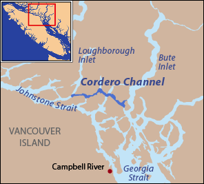
Strait
A strait or straits is a narrow, typically navigable channel of water that connects two larger, navigable bodies of water. It most commonly refers to a channel of water that lies between two land masses, but it may also refer to a navigable channel through a body of water that is otherwise not...
in British Columbia
British Columbia
British Columbia is the westernmost of Canada's provinces and is known for its natural beauty, as reflected in its Latin motto, Splendor sine occasu . Its name was chosen by Queen Victoria in 1858...
, Canada
Canada
Canada is a North American country consisting of ten provinces and three territories. Located in the northern part of the continent, it extends from the Atlantic Ocean in the east to the Pacific Ocean in the west, and northward into the Arctic Ocean...
, located between the mainland and Vancouver Island
Vancouver Island
Vancouver Island is a large island in British Columbia, Canada. It is one of several North American locations named after George Vancouver, the British Royal Navy officer who explored the Pacific Northwest coast of North America between 1791 and 1794...
, among the Discovery Islands
Discovery Islands
The Discovery Islands are the islands in the Discovery Passage between Vancouver Island and the mainland in British Columbia. These islands are sometimes considered to be part of the Northern Gulf Islands....
north of the Strait of Georgia
Strait of Georgia
The Strait of Georgia or the Georgia Strait is a strait between Vancouver Island and the mainland coast of British Columbia, Canada. It is approximately long and varies in width from...
. Cordero Channel runs north of Sonora Island
Sonora Island (British Columbia)
Sonora Island is one of the outer islands of the Discovery Islands of British Columbia, Canada.The island took its name from the Spanish schooner that explored the Pacific Northwest in 1775....
, East Thurlow Island
East Thurlow Island
East Thurlow Island is an island in British Columbia, Canada. It is part of the Discovery Islands, an archipelago between Vancouver Island and the mainland, whose waters connect the Strait of Georgia with Johnstone Strait and Queen Charlotte Strait...
, and part of West Thurlow Island
West Thurlow Island
West Thurlow Island is an island in British Columbia, Canada. It is part of the Discovery Islands, an archipelago between Vancouver Island and the mainland, whose waters connect the Strait of Georgia with Johnstone Strait and Queen Charlotte Strait....
. Its eastern end connects to the mouth of Bute Inlet
Bute Inlet
Bute Inlet is one of the principal inlets of the British Columbia Coast. It is 80 km long from its head at the mouths of the Homathko and Southgate Rivers to the continental headlands at its mouth, where it is nearly blocked by Stuart Island, and it averages about 4 km in width...
and to Calm Channel, at Stuart Island
Stuart Island (British Columbia)
Stuart Island is one of the Discovery Islands of British Columbia, which lie between northern Vancouver Island and the British Columbia Coast. It is privately owned and has no ferry access. It is at the mouth of Bute Inlet to the east of the larger Sonora Island...
. Its west end is marked by the mouth of Loughborough Inlet
Loughborough Inlet
Loughborough Inlet is one of the lesser principal inlets of the British Columbia Coast. It penetrates the Coast Mountains on the north side of the Discovery Islands archipelago, running about from its head at the mouth of the Stafford River to Chancellor Channel and Cordero Channel, which are on...
, beyond which the channel is called Chancellor Channel, which continues west to Johnstone Strait
Johnstone Strait
Johnstone Strait is a channel along the north east coast of Vancouver Island in British Columbia, Canada. Opposite the Vancouver Island coast, running north to south, are Hanson Island, West Cracroft Island, the mainland British Columbia Coast, Hardwick Island, West Thurlow Island and East...
.
There are four tidal rapids along Cordero Channel. The first is either Yuculta Rapids or Arran Rapids, depending on whether the channel is entered on the north or west side of Stuart Island. The following rapids from east to west are Gillard Passage Rapids, Dent Rapids, and Greene Point Rapids.
Cordero Channel was named Canal de Cardero in 1792 during the Spanish expedition of Dionisio Alcalá Galiano
Dionisio Alcalá Galiano
Dionisio Alcalá Galiano was a Spanish naval officer, cartographer, and explorer. He mapped various coastlines in Europe and the Americas with unprecedented accuracy, using new technology such as chronometers...
and Cayetano Valdés y Flores
Cayetano Valdés y Flores
Cayetano Valdés y Flores Bazán was a commander of the Spanish Navy, explorer, and captain general who served in the French Revolutionary and Napoleonic Wars, fighting for both sides at different times due to the changing fortunes of Spain in the conflict...
, in honor of José Cardero
José Cardero
José Cardero was a Spanish draughtsman and artist. He was born in 1766 in Écija, Spain. He is most remembered for his work on the expedition of Alessandro Malaspina and the related expedition of Dionisio Alcalá Galiano. During the Galiano voyage Cordero Channel was named in his honor...
(sometimes called Josef Cardero), the expedition's artist and draftsman. Cardero sailed on board Valdés's ship, the Mexicana
Mexicana (ship)
The Mexicana was a topsail schooner built in 1791 by the Spanish Navy at San Blas, New Spain. It was nearly identical to the Sutil, also built at San Blas later in 1791...
. He had sailed with Alessandro Malaspina
Alessandro Malaspina
Alessandro Malaspina was an Italian nobleman who spent most of his life as a Spanish naval officer and explorer...
from Spain on board the corvette
Corvette
A corvette is a small, maneuverable, lightly armed warship, originally smaller than a frigate and larger than a coastal patrol craft or fast attack craft , although many recent designs resemble frigates in size and role...
Descubierta
Descubierta and Atrevida
The Descubierta and Atrevida were twin corvettes of the Spanish Navy, custom-designed as identical special exploration and scientific research vessels . Both ships were built at the same time for the Malaspina Expedition...
, possibly as a servant. After one of the official artists left Malaspina's expedition in Peru, Cardero began regularly producing drawings and was confirmed as an artist of the expedition in Mexico, in 1791. Like Galiano and Valdés, who had also been part of the Malaspina expedition, Cardero was detached from Malaspina's main mission in order to explore the Strait of Georgia. After they returned to Mexico, Cardero assisted Galiano in preparing reports, maps, and engravings. The name Canal de Cardero changed over time to the present form, Cordero Channel, and expanded in geographic scope to include a larger area. The form "Cardero" survives in the name of Cardero Street in Vancouver
Vancouver
Vancouver is a coastal seaport city on the mainland of British Columbia, Canada. It is the hub of Greater Vancouver, which, with over 2.3 million residents, is the third most populous metropolitan area in the country,...
's West End.
History
The 1792 Spanish expedition of Galiano and Valdés used the term Canal de Cardero for only one part of today's Cordero Channel, that being the portion west of Phillips Arm. Their names for other parts of today's Cordero Channel include Canal de Remolinos (Yuculta Rapids), Angostura de los Commandantes (Arran Rapids), Canal de Carbajal (also Carvajal, north of Sonora Island), Canal del Engaño, and Canal de Olavide (both north of East Thurlow Island and east of Phillips Arm).Near Arran Rapids, which today marks the eastern end of Cordero Channel, the Spanish found a large village whose inhabitants were friendly. They warned the Spanish not to proceed through Arran Rapids because of strong currents and whirlpools. When the tide slackened the Spanish ships as well as a number of indigenous canoes passed through, entering Cordero Channel (this section of which the Spanish called Canal de Carbajal). By use of signs the natives indicated that the channel led to the sea. After making this discovery the Spanish returned to their base of operations where they met with the British expedition of George Vancouver
George Vancouver
Captain George Vancouver RN was an English officer of the British Royal Navy, best known for his 1791-95 expedition, which explored and charted North America's northwestern Pacific Coast regions, including the coasts of contemporary Alaska, British Columbia, Washington and Oregon...
for the last time before rejoining at Nootka Sound
Nootka Sound
Nootka Sound is a complex inlet or sound of the Pacific Ocean on the rugged west coast of Vancouver Island, in the Canadian province of British Columbia. Historically also known as King George's Sound, as a strait it separates Vancouver Island and Nootka Island.-History:The inlet is part of the...
. The Spanish told Vancouver of their discovery of a passage to the sea and their intention to follow it. Soon after, a British scouting boat returned, having found Johnstone Strait. The two expeditions parted ways shortly afterwards, on July 13, 1792, with the British sailing through Discovery Passage
Discovery Passage
Discovery Passage is a channel that forms part of the Inside Passage between Vancouver Island and the Discovery Islands which lie off the British Columbia coast north of the Georgia Strait. It was named by Captain Vancouver for his ship, the HMS Discovery...
and Johnstone Strait, while the Spanish went via Cordero Channel, Chancellor Channel, and Wellbore Channel. According to Galiano's report, Vancouver considered Cordero Channel too dangerous for his ships.
From their anchorage between West Redonda Island
West Redonda Island
West Redonda Island is an island in British Columbia, Canada. It is part of the Discovery Islands, an archipelago between Vancouver Island and the mainland, and between the Strait of Georgia and Johnstone Strait....
and Cortes Island, the Spanish set sail for Cordero Channel on July 13, 1792. They sailed up Calm Channel and around the east side of Stuart Island before finally reaching Arran Rapids (Angostura de los Commandantes), the entrance of Cordero Channel, on July 18. They had difficulty entering and were set back several times. On July 19 they met another group of indigenous people who were catching large quantities of fish in the strait. With some guidance from the natives the Spanish came to better understand the nature of the currents and made a plan for passing through. When the tidal current slackened in the afternoon the Spanish ships entered, yet the current was still swift enough to render the ships incapable of steering. At one point Galiano's ship, the Sutil
Sutil (ship)
The Sutil was a brig-rigged schooner built in 1791 by the Spanish Navy at San Blas, New Spain. It was nearly identical to the Mexicana, also built at San Blas in 1791...
, was caught in a whirlpool, but managed to escape. In the late evening, somewhere near Dent Island, they anchored in a cove, which they gave the name Anclage del Refugio. They named the first part of Cordero Channel Angostura de Carvajal and Canal de Carvajal, in honor of Ciriaco Gonzales Carvajal, an auditor of the Spanish Navy in Mexico (who would preside over the audit of Galiano and Valdés's voyage upon their return).
The Spanish had difficulty passing Dent Rapids, finally managing to do so on July 23. They were again visited by indigenous canoes of the same natives they had met at Arran Rapids (whom they called the "good Indians"). The natives again provided guidance regarding the currents and suggested a route the Spanish ships should take. In addition the natives made maps for the Spanish, showing which channels were closed inlets and which were straits that led to the sea. The maps were made by placing books on a bed and pencils on a piece of paper.
Having reached the northern end of Nodales Channel between Sonora Island and East Thurlow Island, the Spanish decided to continue west along today's Cordero Channel. They called this section of the channel Canal del Engaño. They entered it on July 26 and made quick progress to another section of Cordero Channel they called Canal de Olavide. They were carried by the current into the section they called Canal de Cardero, unable to steer or make way with oars. At the end of the day they were able to anchor at the mouth of Loughborough Inlet (Canal de Salamanca).
The Spanish ships left their anchorage at Viana on July 27, 1792, and entered what is today called Chancellor Channel, thus leaving today's Cordero Channel. When they reached Hardwicke Island they turned to the northwest, leaving Chancellor Channel for Wellbore Channel (Canal de Nuevos Remolinos), which took them to Sunderland Channel and finally Johnstone Strait.