
Colorado State Highway 14
Encyclopedia
State Highway 14 in the U.S.
state of Colorado
is an east–west state highway
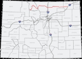
approximately 237 miles (381.4 km) long. One of the longest state highways in Colorado, it traverses four counties along the northern edge of the state, spanning a geography from the continental divide
in the Rocky Mountains
to the Great Plains
, and including North Park
, the Poudre Canyon
, and the Pawnee National Grassland
. It provides the most direct route from Fort Collins
westward via Cameron Pass
to Walden
and Steamboat Springs
, and eastward across the plains to Sterling
.
The highway is two-lane along its entire route, except for portions near Fort Collins where it is concurrent with U.S. Highway 287, and east of Fort Collins near its interchange with Interstate 25.
The western terminus of the highway is on the continental divide, at a junction with U.S. Highway 40 at the summit of Muddy Pass
along the border between Jackson
and Grand
counties. The eastern terminus is at a junction with U.S. Highway 6 in Sterling.
The entire length of the highway is kept open year-round. Despite its western end being on the continental divide itself, Route 14 through Cameron Pass can be one of the more reliable routes across the Front Range
mountains in stormy winter weather.
 Going eastward from Muddy Pass southeast of Steamboat Springs, it transverses through North Park, first going northeast to Walden, then southeast through Gould
along the valley of the Michigan River
. It then transverses along the southern end of the Medicine Bow Mountains
at Cameron Pass
, where it enters Larimer County
. It then descends through the pass to the northwest along the valley of Joe Wright Creek to Chambers Lake, traveling though the mountains along the valley of the Cache la Poudre River
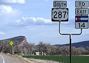
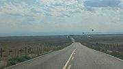
and passing through the Poudre Canyon. It joins U.S. Highway 287 southbound at Teds Place, a longtime local landmark just east of the mouth of the Poudre Canyon. It is concurrent with U.S. Highway 287 southward to Fort Collins, where it splits from 287, going east from downtown Fort Collins along East Mulberry Avenue and reaching Interstate 25 at exit 269. East of I-25, it enters Weld County
and passes through Ault
, where it intersects U.S. Highway 85. East of Ault, it enters a sparsely populated area of the high plains in eastern Weld County, where it passes through three small towns, Briggsdale
, New Raymer, and Stoneham
. Along this stretch it passes alongside several parcels of the Pawnee National Grasslands. Its eastern terminus at Sterling is in central Logan County
, along the South Platte River
, just across the river from Interstate 76.
 The section of the road in Fort Collins that is concurrent with Jefferson Street and Riverside Avenue follows a section of the Overland Trail
, a stage route and emigrant trail used in the 1860s. The section in Fort Collins was known as the "Denver Road". The section up the Poudre Canyon was built in the 1920s.
The route as a Colorado state highway was established in the 1920s from its current western terminus all the way to Nebraska. In 1926, US 38 took over its routing from Sterling, its current eastern terminus, to Nebraska. The route was paved in 1936 from Fort Collins
to Ault
. The entire route was paved by 1963, and the eastern section of the route concurrent with U.S. Route 6
east of Sterling
was eliminated in 1968. The only gap left was eliminated in 1979.
!County
!Location
!Mile
!Destination
!Notes
|-
|rowspan=3|Jackson
|
|0.000
|
|start of route at Muddy Pass
|-
|rowspan=2|Walden
|32.968
|
|begin SH 125 concurrency
|-
|34.090
|
|end SH 125 concurrency
|-
|rowspan=4|Larimer
|
|121.713
|
|begin US 287 concurrency
|-
|rowspan=3|Fort Collins
|128.934
|
|
|-
|134.770
|
|end US 287 concurrency
|-
|138.968
|
|
|-
|rowspan=5|Weld
|
|144.152
|
|
|-
|Ault
|153.370
|
|
|-
|Raymer
|205.236
|
|
|-
|
|211.807
|
|begin SH 71 concurrency
|-
|
|215.828
|
|end SH 71 concurrency
|-
|rowspan=2|Logan
|rowspan=2|Sterling
|236.824
|
|
|-
|236.924
|
|end of route
United States
The United States of America is a federal constitutional republic comprising fifty states and a federal district...
state of Colorado
Colorado
Colorado is a U.S. state that encompasses much of the Rocky Mountains as well as the northeastern portion of the Colorado Plateau and the western edge of the Great Plains...
is an east–west state highway
State highway
State highway, state road or state route can refer to one of three related concepts, two of them related to a state or provincial government in a country that is divided into states or provinces :#A...
approximately 237 miles (381.4 km) long. One of the longest state highways in Colorado, it traverses four counties along the northern edge of the state, spanning a geography from the continental divide
Continental divide
A continental divide is a drainage divide on a continent such that the drainage basin on one side of the divide feeds into one ocean or sea, and the basin on the other side either feeds into a different ocean or sea, or else is endorheic, not connected to the open sea...
in the Rocky Mountains
Rocky Mountains
The Rocky Mountains are a major mountain range in western North America. The Rocky Mountains stretch more than from the northernmost part of British Columbia, in western Canada, to New Mexico, in the southwestern United States...
to the Great Plains
Great Plains
The Great Plains are a broad expanse of flat land, much of it covered in prairie, steppe and grassland, which lies west of the Mississippi River and east of the Rocky Mountains in the United States and Canada. This area covers parts of the U.S...
, and including North Park
North Park (Colorado basin)
North Park is a high, sparsely populated basin in the Rocky Mountains in north central Colorado in the United States. It encompasses a wide valley in Jackson County rimmed by mountain ranges at the headwaters of the North Platte River and several smaller tributaries, including the Michigan River,...
, the Poudre Canyon
Poudre Canyon
The Poudre Canyon is a narrow verdant canyon, approximately 40 mi long, on the upper Cache la Poudre River in Larimer County, Colorado in the United States...
, and the Pawnee National Grassland
Pawnee National Grassland
Pawnee National Grassland is a United States National Grassland located in northeastern Colorado on the Colorado Eastern Plains. The grassland is located in the South Platte River basin in remote northern and extreme northeastern Weld County between Greeley and Sterling...
. It provides the most direct route from Fort Collins
Fort Collins, Colorado
Fort Collins is a Home Rule Municipality situated on the Cache La Poudre River along the Colorado Front Range, and is the county seat and most populous city of Larimer County, Colorado, United States. Fort Collins is located north of the Colorado State Capitol in Denver. With a 2010 census...
westward via Cameron Pass
Cameron Pass (Colorado)
Cameron Pass is a elevation mountain pass in the Rocky Mountains in north central Colorado in the United States. The pass is a gap between the south end of the Medicine Bow Mountains and the north end of the Never Summer Mountains. It sits on the border between Jackson County and Larimer County,...
to Walden
Walden, Colorado
The Town of Walden is a Statutory Town that is the county seat of, and the only incorporated municipality in, Jackson County, Colorado, United States. It is situated in the center of a large open valley called North Park. People from Walden and the surrounding area refer to themselves as "North...
and Steamboat Springs
Steamboat Springs, Colorado
The city of Steamboat Springs is a Home Rule Municipality that is the county seat and the most populous city of Routt County, Colorado, United States. The city is also known as "Steamboat," "The Boat," or "Ski Town USA". As of the 2010 census, the city population was 12,088.The city is an...
, and eastward across the plains to Sterling
Sterling, Colorado
The City of Sterling is a Home Rule Municipality that is the county seat and the most populous city of Logan County, Colorado, United States. The city population was 14,777 at the 2010 census.-Geography:Sterling is located at...
.
The highway is two-lane along its entire route, except for portions near Fort Collins where it is concurrent with U.S. Highway 287, and east of Fort Collins near its interchange with Interstate 25.
The western terminus of the highway is on the continental divide, at a junction with U.S. Highway 40 at the summit of Muddy Pass
Muddy Pass
Muddy Pass is a high mountain pass in the Rocky Mountains of northern Colorado in the United States.The pass straddles the continental divide along the boundary between Jackson and Grand counties. The pass separates North Park and the headwaters of the North Platte River with Middle Park near the...
along the border between Jackson
Jackson County, Colorado
Jackson County is the fourth-least densely populated of the Colorado 64 counties of the U.S. state of Colorado. The county population was 1,577 at the 2000 Census. The county seat and the only municipality in the county is the Town of Walden.- History :...
and Grand
Grand County, Colorado
Grand County is the 21st largest of the 64 counties of the State of Colorado of the United States. The county population was 12,442 at U.S. Census 2000...
counties. The eastern terminus is at a junction with U.S. Highway 6 in Sterling.
The entire length of the highway is kept open year-round. Despite its western end being on the continental divide itself, Route 14 through Cameron Pass can be one of the more reliable routes across the Front Range
Front Range
The Front Range is a mountain range of the Southern Rocky Mountains of North America located in the north-central portion of the U.S. State of Colorado and southeastern portion of the U.S. State of Wyoming. It is the first mountain range encountered moving west along the 40th parallel north across...
mountains in stormy winter weather.
Route description
Gould, Colorado
Gould is a small unincorporated community in southeastern Jackson County, Colorado, United States. It is located on State Highway 14, southeast of Walden in North Park. The community is situated in the valley of the Middle Fork of the Michigan River between Owl Mountain and Gould Mountain. The...
along the valley of the Michigan River
Michigan River
The Michigan River is a tributary of the North Platte River, approximately long, in north central Colorado in the United States. It drains a rural part of the eastern side of North Park in eastern Jackson County. The river issues from Michigan Lakes, a chain of alpine lakes at , along the...
. It then transverses along the southern end of the Medicine Bow Mountains
Medicine Bow Mountains
The Medicine Bow Mountains are a mountain range in the Rocky Mountains that extend for from northern Colorado into southern Wyoming. The northern extent of this range is the sub-range the Snowy Range...
at Cameron Pass
Cameron Pass (Colorado)
Cameron Pass is a elevation mountain pass in the Rocky Mountains in north central Colorado in the United States. The pass is a gap between the south end of the Medicine Bow Mountains and the north end of the Never Summer Mountains. It sits on the border between Jackson County and Larimer County,...
, where it enters Larimer County
Larimer County, Colorado
Larimer County is the seventh most populous and the ninth most extensive of the 64 counties of the State of Colorado of the United States. The county is located at the northern end of the Front Range, at the edge of the Colorado Eastern Plains along the border with Wyoming...
. It then descends through the pass to the northwest along the valley of Joe Wright Creek to Chambers Lake, traveling though the mountains along the valley of the Cache la Poudre River
Cache La Poudre River
The Cache la Poudre River is in the state of Colorado in the United States.Its headwaters are in the Front Range in Larimer County, in the northern part of Rocky Mountain National Park. The river descends eastward in the mountains through the Roosevelt National Forest in Poudre Canyon...
and passing through the Poudre Canyon. It joins U.S. Highway 287 southbound at Teds Place, a longtime local landmark just east of the mouth of the Poudre Canyon. It is concurrent with U.S. Highway 287 southward to Fort Collins, where it splits from 287, going east from downtown Fort Collins along East Mulberry Avenue and reaching Interstate 25 at exit 269. East of I-25, it enters Weld County
Weld County, Colorado
As of the census of 2000, there were 180,936 people, 63,247 households, and 45,221 families residing in the county. The population density was 45 people per square mile . There were 66,194 housing units at an average density of 17 per square mile...
and passes through Ault
Ault, Colorado
The Town of Ault is a Statutory Town located in Weld County, Colorado, United States. The population was 1,432 at the U.S. Census 2000.-Geography:Ault is located at , at the intersection of U.S...
, where it intersects U.S. Highway 85. East of Ault, it enters a sparsely populated area of the high plains in eastern Weld County, where it passes through three small towns, Briggsdale
Briggsdale, Colorado
Briggsdale is an unincorporated town and U.S. Post Office in Weld County, Colorado, United States. The ZIP Code of the Briggsdale Post Office is 80611.-History:...
, New Raymer, and Stoneham
Stoneham, Colorado
Stoneham is an unincorporated town and a U.S. Post Office located in Weld County, Colorado, United States. The Stoneham Post Office has the ZIP Code 80754.Stoneham is northeast of Denver.- Geography :Stoneham is located at ....
. Along this stretch it passes alongside several parcels of the Pawnee National Grasslands. Its eastern terminus at Sterling is in central Logan County
Logan County, Colorado
Logan County is the 23rd most extensive of the 64 counties of the State of Colorado of the United States. The county was named for General John A. Logan. The county population was 20,504 at U.S. Census 2000. The county seat is Sterling...
, along the South Platte River
South Platte River
The South Platte River is one of the two principal tributaries of the Platte River and itself a major river of the American Midwest and the American Southwest/Mountain West, located in the U.S. states of Colorado and Nebraska...
, just across the river from Interstate 76.
History
Overland Trail
The Overland Trail was a stagecoach and wagon trail in the American West during the 19th century. While portions of the route had been used by explorers and trappers since the 1820s, the Overland Trail was most heavily used in the 1860s as an alternative route to the Oregon, California and Mormon...
, a stage route and emigrant trail used in the 1860s. The section in Fort Collins was known as the "Denver Road". The section up the Poudre Canyon was built in the 1920s.
The route as a Colorado state highway was established in the 1920s from its current western terminus all the way to Nebraska. In 1926, US 38 took over its routing from Sterling, its current eastern terminus, to Nebraska. The route was paved in 1936 from Fort Collins
Fort Collins, Colorado
Fort Collins is a Home Rule Municipality situated on the Cache La Poudre River along the Colorado Front Range, and is the county seat and most populous city of Larimer County, Colorado, United States. Fort Collins is located north of the Colorado State Capitol in Denver. With a 2010 census...
to Ault
Ault, Colorado
The Town of Ault is a Statutory Town located in Weld County, Colorado, United States. The population was 1,432 at the U.S. Census 2000.-Geography:Ault is located at , at the intersection of U.S...
. The entire route was paved by 1963, and the eastern section of the route concurrent with U.S. Route 6
U.S. Route 6
U.S. Route 6 , also called the Grand Army of the Republic Highway, a name that honors an American Civil War veterans association, is a main route of the U.S. Highway system, running east-northeast from Bishop, California to Provincetown, Massachusetts. Until 1964, it continued south from Bishop to...
east of Sterling
Sterling, Colorado
The City of Sterling is a Home Rule Municipality that is the county seat and the most populous city of Logan County, Colorado, United States. The city population was 14,777 at the 2010 census.-Geography:Sterling is located at...
was eliminated in 1968. The only gap left was eliminated in 1979.
Major intersections
{| class=wikitable!County
!Location
!Mile
!Destination
!Notes
|-
|rowspan=3|Jackson
Jackson County, Colorado
Jackson County is the fourth-least densely populated of the Colorado 64 counties of the U.S. state of Colorado. The county population was 1,577 at the 2000 Census. The county seat and the only municipality in the county is the Town of Walden.- History :...
|
|0.000
|
|start of route at Muddy Pass
Muddy Pass
Muddy Pass is a high mountain pass in the Rocky Mountains of northern Colorado in the United States.The pass straddles the continental divide along the boundary between Jackson and Grand counties. The pass separates North Park and the headwaters of the North Platte River with Middle Park near the...
|-
|rowspan=2|Walden
Walden, Colorado
The Town of Walden is a Statutory Town that is the county seat of, and the only incorporated municipality in, Jackson County, Colorado, United States. It is situated in the center of a large open valley called North Park. People from Walden and the surrounding area refer to themselves as "North...
|32.968
|
|begin SH 125 concurrency
|-
|34.090
|
|end SH 125 concurrency
|-
|rowspan=4|Larimer
Larimer County, Colorado
Larimer County is the seventh most populous and the ninth most extensive of the 64 counties of the State of Colorado of the United States. The county is located at the northern end of the Front Range, at the edge of the Colorado Eastern Plains along the border with Wyoming...
|
|121.713
|
|begin US 287 concurrency
|-
|rowspan=3|Fort Collins
Fort Collins, Colorado
Fort Collins is a Home Rule Municipality situated on the Cache La Poudre River along the Colorado Front Range, and is the county seat and most populous city of Larimer County, Colorado, United States. Fort Collins is located north of the Colorado State Capitol in Denver. With a 2010 census...
|128.934
|
|
|-
|134.770
|
|end US 287 concurrency
|-
|138.968
|
|
|-
|rowspan=5|Weld
Weld County, Colorado
As of the census of 2000, there were 180,936 people, 63,247 households, and 45,221 families residing in the county. The population density was 45 people per square mile . There were 66,194 housing units at an average density of 17 per square mile...
|
|144.152
|
|
|-
|Ault
Ault, Colorado
The Town of Ault is a Statutory Town located in Weld County, Colorado, United States. The population was 1,432 at the U.S. Census 2000.-Geography:Ault is located at , at the intersection of U.S...
|153.370
|
|
|-
|Raymer
Raymer, Colorado
The Town of Raymer is a Statutory Town located in Weld County, Colorado, United States. The population was 91 at the U.S. Census 2000.The community has two official names:*Raymer - The legal name of the incorporated Town of Raymer....
|205.236
|
|
|-
|
|211.807
|
|begin SH 71 concurrency
|-
|
|215.828
|
|end SH 71 concurrency
|-
|rowspan=2|Logan
Logan County, Colorado
Logan County is the 23rd most extensive of the 64 counties of the State of Colorado of the United States. The county was named for General John A. Logan. The county population was 20,504 at U.S. Census 2000. The county seat is Sterling...
|rowspan=2|Sterling
Sterling, Colorado
The City of Sterling is a Home Rule Municipality that is the county seat and the most populous city of Logan County, Colorado, United States. The city population was 14,777 at the 2010 census.-Geography:Sterling is located at...
|236.824
|
|
|-
|236.924
|
|end of route