
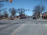
Sterling, Colorado
Encyclopedia
The City of Sterling is a Home Rule Municipality that is the county seat
and the most populous city of Logan County
, Colorado
, United States
. The city population was 14,777 at the 2010 census.
According to the United States Census Bureau
, the city has a total area of 6.9 square miles (17.9 km²), all of it land.
an visitors (post-Spanish exploration) to the area were primarily French fur trappers
searching for fertile beaver
streams in the late-1700s. By that time, the principal Indian tribes occupying the region were the Arapaho and Cheyenne, although war and hunting parties of other Plains tribes such as the Sioux and Pawnee probably passed through. Organized exploration of the area by Americans began with the visit on June 26, 1820 of the expedition of Major Stephen Harriman Long, who referred to much of the area between the Missouri River
and the Rocky Mountains
as "The Great American Desert
". One of the final battles of the Indian wars in Colorado, the Battle of Summit Springs
between Tall Bull and his Cheyenne Dog Soldiers and Colonel Eugene A. Carr and the U.S. Army
took place near Sterling on July 11, 1869.
The Overland Trail, a branch of the Oregon Trail
, was one of the most heavily traveled in the country. Between 1862-68, thousands of brave and adventurous people pressed across the unmarked prairie in search of opportunity. Early settlers in northeastern Colorado such as John Iliff developed huge cattle ranching empires in the region, leading to the first economic base. Businesses, stores, and other operations soon followed, especially after the arrival of the railroads in 1881.
William Hadfield arrived in the northeastern Colorado in 1871 and established his home on an island in the South Platte River
, a few miles south of present day Sterling, where a post office was soon established. Mr. Hadfield is credited with being the first permanent white settler in the area.
A number of early settlers first settled in the Union Colony
, now Greeley, Colorado
, but found the best farmland already taken, so came back east along the South Platte river and formed the first town of Sterling, about four miles (6 km) north of the present town site. Here they built sod huts and dugouts along the treeless river valley.

 In 1881 news arrived that the Union Pacific Railroad
was going to extend its line from Julesburg, Colorado
to La Salle, Colorado
. Citizens from “old Sterling” knew that if a railroad came through this territory, a town would be established somewhere near their settlement. Local leader Minos King therefore traveled to Omaha, Nebraska
to meet with railroad officials to offer them 80 acres (323,748.8 m²) of land for a right-of-way if shops and a roundhouse were located there.
The current site where Sterling stands was owned John E. Boyd, who sold it to King for $400. The site for the new town was surveyed and platted by railroad surveyor David Leavitt, from Sterling, Illinois. While living in Sterling (Colorado) Mr. Leavitt was also Justice of the Peace, lawyer, and civil engineer. Mrs. Leavitt was a physician who also served as the first postmistress in the new town of Sterling.
The new town was composed of 19 blocks bordered by what is now Front Street, Cedar Street, Fourth Street, and Division Avenue. The northern boundary was a diagonal line extending a little north of the corner of what is now Chestnut and Front Streets – to about where the railroad tracks cross Main Street. The railroad tracks followed the diagonal of the South Platte River; hence, the old part of Sterling is on the diagonal. From Division Avenue westward the streets now run true north and south (and east and west). To encourage development of the town, King donated lots for a church, for schools, other public buildings, and for a cemetery – the old cemetery north of town now abandoned.
After laying out the new town, most of the settlers from the old Sterling settlement moved to the new locality. King and R.E. Smith opened the first lumberyard and general store. As soon as the railroad went through in 1881, a section house and depot were built. It was not long before the Pacific Hotel near the depot was built. In 1884, city articles of incorporation were completed, with George Wilson elected as mayor. In 1887 with the creation of Logan County, Sterling was made the county seat by governor Alva Adams
.
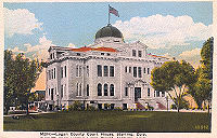

 Sterling is the largest city in Northeastern Colorado and the county seat of Logan County and the site of the domed Logan County courthouse, built in 1909.
Sterling is the home of Northeastern Junior College
, a residential two year liberal arts college in Colorado.
Sterling is also the location of the award winning RE-1 Valley School District, excepting the principals of the High School, whose academics, music programs, and athletics programs are consistently among the most highly rated in the state of Colorado.
Major employers in Sterling include Northeastern Junior College, the RE-1 Valley School system, Sykes Enterprises, a computer software customer services company, and the Sterling Correctional Facility.
Sterling is the major shopping hub for most of northeastern Colorado and hosts stores like Wal-Mart, The Home Depot, and J. C. Penney, as well as many local retailers located primarily on Main Street. Six different banks have branches in Sterling and there are local AM and FM radio stations as well as a local television station, and a long established regional newspaper, the Sterling Journal-Advocate and South Platte Sentinel http://www.southplattesentinel.com.
Sterling is a regional center for health care as well, and is the home of the Sterling Regional Medical Center.
Pheasant, duck, and deer hunting are excellent in the high plains and South Platte River Valley surrounding Sterling.
Sterling is the home of two beautiful golf courses, Riverview Golf Course and the Northeastern Eighteen (the former Sterling Country Club - now owned by Northeastern Junior College), each offering excellent 18-hole courses.
The Overland Trail Museum, located east of Sterling near Interstate 76, houses an eclectic mix of historical items in the main building, which resembles an early fort, as well as a restored local one-room schoolhouse and other restored historical buildings. Museum admission is three dollars, and picnic grounds are adjacent.
The Overland Trail Recreation Area features a 5 acres (20,234.3 m²) fishing pond open to all ages as well as biking trails, grass, trees, fishing, picnic tables, BBQ grills, walking path, off road parking, restroom, and fishing pier.
Each summer, Sterling hosts the annual Logan County Fair, a typical old-time county fair complete with 4-H animal shows, baked goods competitions, a carnival, music shows, demolition derby, and a rodeo as well as the annual Sugar Beet Days harvest festival in the fall.
The Recreation Center now has an indoor pool with a capacity of 225, including the diving well and an outdoor pool with a capacity of nearly 450. The outdoor pool includes several water features including a Multi-Play 5 and three slides The pool has a 50x50 beach entry as well as a separate wading pool with a mini water dome and six water jets.
The largest attraction at the pool is the double flumed slide, complete with a translucent blue speed slide about 130 feet long and one open flume slide about 220 feet long. Picnic tables and chairs can accommodate over 300 patrons and the seven shade structures provide plenty of protection from the sun's ultra violet rays.
http://www.sterlingcolo.com/pages/dept/plr/reccenter.php
, located 121 miles (194.7 km) away.
Sterling is also served by railroads, although only freight carriers serve the town. The main rail operator is Burlington Northern Santa Fe (BNSF), but other operators, like Union Pacific, serve Sterling as well. The closest Amtrak
station is located in Fort Morgan
, about 47 miles (75.6 km) away.
of 2000, there were 11,360 people, 4,604 households, and 2,790 families residing in the city. The population density
was 1,653.1 people per square mile (638.4/km²). There were 5,171 housing units at an average density of 752.5 per square mile (290.6/km²). The racial makeup of the city was 90.75% Caucasian American, 0.75% African American, 0.79% Native American, 0.41% Asian, 0.08% Pacific Islander, 5.60% from other races
, and 1.62% from two or more races. Hispanic or Latino of any race were 14.20% of the population.
There were 4,604 households out of which 30.6% had children under the age of 18 living with them, 46.2% were married couples
living together, 10.8% had a female householder with no husband present, and 39.4% were non-families. 34.1% of all households were made up of individuals and 14.7% had someone living alone who was 65 years of age or older. The average household size was 2.34 and the average family size was 3.03.
In the city the population was spread out with 25.5% under the age of 18, 12.9% from 18 to 24, 25.5% from 25 to 44, 19.6% from 45 to 64, and 16.4% who were 65 years of age or older. The median age was 35 years. For every 100 females there were 94.7 males. For every 100 females age 18 and over, there were 91.2 males.
The median income for a household in the city was $27,337, and the median income for a family was $39,103. Males had a median income of $27,921 versus $20,508 for females. The per capita income
for the city was $15,287.
County seat
A county seat is an administrative center, or seat of government, for a county or civil parish. The term is primarily used in the United States....
and the most populous city of Logan County
Logan County, Colorado
Logan County is the 23rd most extensive of the 64 counties of the State of Colorado of the United States. The county was named for General John A. Logan. The county population was 20,504 at U.S. Census 2000. The county seat is Sterling...
, Colorado
Colorado
Colorado is a U.S. state that encompasses much of the Rocky Mountains as well as the northeastern portion of the Colorado Plateau and the western edge of the Great Plains...
, United States
United States
The United States of America is a federal constitutional republic comprising fifty states and a federal district...
. The city population was 14,777 at the 2010 census.
Geography
Sterling is located at 40°37′32"N 103°12′42"W (40.625430, -103.211783). It is 128 miles (206 km) northeast of Denver, and is located on Interstate 76, on the 'eastern plains' of northeastern Colorado.According to the United States Census Bureau
United States Census Bureau
The United States Census Bureau is the government agency that is responsible for the United States Census. It also gathers other national demographic and economic data...
, the city has a total area of 6.9 square miles (17.9 km²), all of it land.
History
The original inhabitants of the Colorado High Plains near Sterling were probably paleo-Indians of the Clovis culture. The earliest known EuropeEurope
Europe is, by convention, one of the world's seven continents. Comprising the westernmost peninsula of Eurasia, Europe is generally 'divided' from Asia to its east by the watershed divides of the Ural and Caucasus Mountains, the Ural River, the Caspian and Black Seas, and the waterways connecting...
an visitors (post-Spanish exploration) to the area were primarily French fur trappers
Mountain man
Mountain men were trappers and explorers who roamed the North American Rocky Mountains from about 1810 through the 1880s where they were instrumental in opening up the various Emigrant Trails allowing Americans in the east to settle the new territories of the far west by organized wagon trains...
searching for fertile beaver
American Beaver
The North American Beaver is the only species of beaver in the Americas, native to North America and introduced to South America. In the United States and Canada, where no other species of beaver occurs, it is usually simply referred to as "beaver"...
streams in the late-1700s. By that time, the principal Indian tribes occupying the region were the Arapaho and Cheyenne, although war and hunting parties of other Plains tribes such as the Sioux and Pawnee probably passed through. Organized exploration of the area by Americans began with the visit on June 26, 1820 of the expedition of Major Stephen Harriman Long, who referred to much of the area between the Missouri River
Missouri River
The Missouri River flows through the central United States, and is a tributary of the Mississippi River. It is the longest river in North America and drains the third largest area, though only the thirteenth largest by discharge. The Missouri's watershed encompasses most of the American Great...
and the Rocky Mountains
Rocky Mountains
The Rocky Mountains are a major mountain range in western North America. The Rocky Mountains stretch more than from the northernmost part of British Columbia, in western Canada, to New Mexico, in the southwestern United States...
as "The Great American Desert
Great American Desert
The term Great American Desert was used in the 19th century to describe the western part of the Great Plains east of the Rocky Mountains in North America....
". One of the final battles of the Indian wars in Colorado, the Battle of Summit Springs
Battle of Summit Springs
The Battle of Summit Springs, on July 11, 1869, was an armed conflict between elements of the United States Army under the command of Colonel Eugene A. Carr and a group of Cheyenne Dog Soldiers led by Tall Bull, who died during the engagement...
between Tall Bull and his Cheyenne Dog Soldiers and Colonel Eugene A. Carr and the U.S. Army
United States Army
The United States Army is the main branch of the United States Armed Forces responsible for land-based military operations. It is the largest and oldest established branch of the U.S. military, and is one of seven U.S. uniformed services...
took place near Sterling on July 11, 1869.
The Overland Trail, a branch of the Oregon Trail
Oregon Trail
The Oregon Trail is a historic east-west wagon route that connected the Missouri River to valleys in Oregon and locations in between.After 1840 steam-powered riverboats and steamboats traversing up and down the Ohio, Mississippi and Missouri rivers sped settlement and development in the flat...
, was one of the most heavily traveled in the country. Between 1862-68, thousands of brave and adventurous people pressed across the unmarked prairie in search of opportunity. Early settlers in northeastern Colorado such as John Iliff developed huge cattle ranching empires in the region, leading to the first economic base. Businesses, stores, and other operations soon followed, especially after the arrival of the railroads in 1881.
William Hadfield arrived in the northeastern Colorado in 1871 and established his home on an island in the South Platte River
South Platte River
The South Platte River is one of the two principal tributaries of the Platte River and itself a major river of the American Midwest and the American Southwest/Mountain West, located in the U.S. states of Colorado and Nebraska...
, a few miles south of present day Sterling, where a post office was soon established. Mr. Hadfield is credited with being the first permanent white settler in the area.
A number of early settlers first settled in the Union Colony
Union Colony of Colorado
The Union Colony of Colorado was a 19th century U.S. private enterprise formed to promote agricultural settlement in the South Platte River valley in the Colorado Territory...
, now Greeley, Colorado
Greeley, Colorado
The City of Greeley is a Home Rule Municipality that is the county seat and the most populous city of Weld County, Colorado, United States. Greeley is located in the region known as Northern Colorado. Greeley is situated north-northeast of the Colorado State Capitol in Denver. According to the...
, but found the best farmland already taken, so came back east along the South Platte river and formed the first town of Sterling, about four miles (6 km) north of the present town site. Here they built sod huts and dugouts along the treeless river valley.
Union Pacific Railroad
The Union Pacific Railroad , headquartered in Omaha, Nebraska, is the largest railroad network in the United States. James R. Young is president, CEO and Chairman....
was going to extend its line from Julesburg, Colorado
Julesburg, Colorado
The historic town of Julesburg is a statutory town that is the county seat of Sedgwick County, Colorado, United States. The town is located on the north side of the South Platte River. The population was 1,467 at the U.S. Census 2000...
to La Salle, Colorado
La Salle, Colorado
La Salle is a Statutory Town in Weld County, Colorado, United States. The population was 1,849 at the 2000 census.-Geography:La Salle is located at ....
. Citizens from “old Sterling” knew that if a railroad came through this territory, a town would be established somewhere near their settlement. Local leader Minos King therefore traveled to Omaha, Nebraska
Omaha, Nebraska
Omaha is the largest city in the state of Nebraska, United States, and is the county seat of Douglas County. It is located in the Midwestern United States on the Missouri River, about 20 miles north of the mouth of the Platte River...
to meet with railroad officials to offer them 80 acres (323,748.8 m²) of land for a right-of-way if shops and a roundhouse were located there.
The current site where Sterling stands was owned John E. Boyd, who sold it to King for $400. The site for the new town was surveyed and platted by railroad surveyor David Leavitt, from Sterling, Illinois. While living in Sterling (Colorado) Mr. Leavitt was also Justice of the Peace, lawyer, and civil engineer. Mrs. Leavitt was a physician who also served as the first postmistress in the new town of Sterling.
The new town was composed of 19 blocks bordered by what is now Front Street, Cedar Street, Fourth Street, and Division Avenue. The northern boundary was a diagonal line extending a little north of the corner of what is now Chestnut and Front Streets – to about where the railroad tracks cross Main Street. The railroad tracks followed the diagonal of the South Platte River; hence, the old part of Sterling is on the diagonal. From Division Avenue westward the streets now run true north and south (and east and west). To encourage development of the town, King donated lots for a church, for schools, other public buildings, and for a cemetery – the old cemetery north of town now abandoned.
After laying out the new town, most of the settlers from the old Sterling settlement moved to the new locality. King and R.E. Smith opened the first lumberyard and general store. As soon as the railroad went through in 1881, a section house and depot were built. It was not long before the Pacific Hotel near the depot was built. In 1884, city articles of incorporation were completed, with George Wilson elected as mayor. In 1887 with the creation of Logan County, Sterling was made the county seat by governor Alva Adams
Alva Adams (governor)
Alva Adams was an American politician. He was born in Iowa County, Wisconsin. He served as the fifth, tenth and 14th Governor of Colorado from 1887 to 1889, 1897 to 1899, and briefly in 1905. He died in Battle Creek, Michigan.Adams County, Colorado, is named for Alva Adams, and it's believed the...
.
Infrastructure
Sterling is the home of Northeastern Junior College
Northeastern Junior College
Northeastern Community College is a two-year junior college located in Sterling, Colorado, in the United States. It is a member college of the Colorado Community College System.-Academics:...
, a residential two year liberal arts college in Colorado.
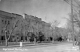
Sterling is also the location of the award winning RE-1 Valley School District, excepting the principals of the High School, whose academics, music programs, and athletics programs are consistently among the most highly rated in the state of Colorado.
Major employers in Sterling include Northeastern Junior College, the RE-1 Valley School system, Sykes Enterprises, a computer software customer services company, and the Sterling Correctional Facility.
Sterling is the major shopping hub for most of northeastern Colorado and hosts stores like Wal-Mart, The Home Depot, and J. C. Penney, as well as many local retailers located primarily on Main Street. Six different banks have branches in Sterling and there are local AM and FM radio stations as well as a local television station, and a long established regional newspaper, the Sterling Journal-Advocate and South Platte Sentinel http://www.southplattesentinel.com.
Sterling is a regional center for health care as well, and is the home of the Sterling Regional Medical Center.
Recreation
Just a few miles northeast of Sterling is located the North Sterling State Park, situated on the North Sterling Reservoir, a man-made lake fed by waters from the South Platte River. This new state park has three state of the art boat ramps, and three modern camping areas with over 150 camping sites, as well as multiple picnicking sites. The park is famous for its superb swimming, boating, waterskiing, camping, and fishing.Pheasant, duck, and deer hunting are excellent in the high plains and South Platte River Valley surrounding Sterling.
Sterling is the home of two beautiful golf courses, Riverview Golf Course and the Northeastern Eighteen (the former Sterling Country Club - now owned by Northeastern Junior College), each offering excellent 18-hole courses.
The Overland Trail Museum, located east of Sterling near Interstate 76, houses an eclectic mix of historical items in the main building, which resembles an early fort, as well as a restored local one-room schoolhouse and other restored historical buildings. Museum admission is three dollars, and picnic grounds are adjacent.
The Overland Trail Recreation Area features a 5 acres (20,234.3 m²) fishing pond open to all ages as well as biking trails, grass, trees, fishing, picnic tables, BBQ grills, walking path, off road parking, restroom, and fishing pier.
Each summer, Sterling hosts the annual Logan County Fair, a typical old-time county fair complete with 4-H animal shows, baked goods competitions, a carnival, music shows, demolition derby, and a rodeo as well as the annual Sugar Beet Days harvest festival in the fall.
The Recreation Center now has an indoor pool with a capacity of 225, including the diving well and an outdoor pool with a capacity of nearly 450. The outdoor pool includes several water features including a Multi-Play 5 and three slides The pool has a 50x50 beach entry as well as a separate wading pool with a mini water dome and six water jets.
The largest attraction at the pool is the double flumed slide, complete with a translucent blue speed slide about 130 feet long and one open flume slide about 220 feet long. Picnic tables and chairs can accommodate over 300 patrons and the seven shade structures provide plenty of protection from the sun's ultra violet rays.
http://www.sterlingcolo.com/pages/dept/plr/reccenter.php
Transportation
Crosson Field Municipal Airport serves Sterling, but there are no scheduled flights available from there. The closest airport served by scheduled flights is Denver International AirportDenver International Airport
Denver International Airport , often referred to as DIA, is an airport in Denver, Colorado. By land size, at , it is the largest international airport in the United States, and the third largest international airport in the world after King Fahd International Airport and Montréal-Mirabel...
, located 121 miles (194.7 km) away.
Sterling is also served by railroads, although only freight carriers serve the town. The main rail operator is Burlington Northern Santa Fe (BNSF), but other operators, like Union Pacific, serve Sterling as well. The closest Amtrak
Amtrak
The National Railroad Passenger Corporation, doing business as Amtrak , is a government-owned corporation that was organized on May 1, 1971, to provide intercity passenger train service in the United States. "Amtrak" is a portmanteau of the words "America" and "track". It is headquartered at Union...
station is located in Fort Morgan
Fort Morgan, Colorado
The City of Fort Morgan is a Home Rule Municipality that is the county seat and the most populous city of Morgan County, Colorado, United States. The United States Census Bureau estimated that the city population was 10,844 in 2005.-History:...
, about 47 miles (75.6 km) away.
Major Highways
 Interstate 76 connects Sterling to DenverDenver, ColoradoThe City and County of Denver is the capital and the most populous city of the U.S. state of Colorado. Denver is a consolidated city-county, located in the South Platte River Valley on the western edge of the High Plains just east of the Front Range of the Rocky Mountains...
(128 miles (206 km) southwest) and northeast to Interstate 80, in Big SpringsBig Springs, NebraskaBig Springs is a village in Deuel County, Nebraska, United States. The population was 418 at the 2000 census.-Geography:Big Springs is located at ....
, NebraskaNebraskaNebraska is a state on the Great Plains of the Midwestern United States. The state's capital is Lincoln and its largest city is Omaha, on the Missouri River....
, along the South Platte RiverSouth Platte RiverThe South Platte River is one of the two principal tributaries of the Platte River and itself a major river of the American Midwest and the American Southwest/Mountain West, located in the U.S. states of Colorado and Nebraska...
. Business Loop 76 starts on the intersection of Interstate 76 and US 6, going through East Chestnut Street, North and South 4th Street, South Division Avenue, returning to US 6, connecting Sterling to AtwoodAtwood, ColoradoAtwood is a census-designated place in Logan County, Colorado, United States. The population was 133 at the 2010 census. The Atwood Post Office has the ZIP Code 80722.-Geography:Atwood is located at ....
and MerinoMerino, ColoradoMerino is a Statutory Town in Logan County, Colorado, United States. The population was 246 at the 2000 census.-Geography:Merino is located at ....
. US 6 runs east-west linking ProvincetownProvincetown, MassachusettsProvincetown is a New England town located at the extreme tip of Cape Cod in Barnstable County, Massachusetts, United States. The population was 3,431 at the 2000 census, with an estimated 2007 population of 3,174...
, MassachusettsMassachusettsThe Commonwealth of Massachusetts is a state in the New England region of the northeastern United States of America. It is bordered by Rhode Island and Connecticut to the south, New York to the west, and Vermont and New Hampshire to the north; at its east lies the Atlantic Ocean. As of the 2010...
with BishopBishop, CaliforniaBishop is a city in Inyo County, California, United States. Though Bishop is the only city and the largest populated place in Inyo County, the county seat is Independence. Bishop is located near the northern end of the Owens Valley, at an elevation of 4147 feet . The population was 3,879 at the...
, CaliforniaCaliforniaCalifornia is a state located on the West Coast of the United States. It is by far the most populous U.S. state, and the third-largest by land area...
, via NevadaNevadaNevada is a state in the western, mountain west, and southwestern regions of the United States. With an area of and a population of about 2.7 million, it is the 7th-largest and 35th-most populous state. Over two-thirds of Nevada's people live in the Las Vegas metropolitan area, which contains its...
, ColoradoColoradoColorado is a U.S. state that encompasses much of the Rocky Mountains as well as the northeastern portion of the Colorado Plateau and the western edge of the Great Plains...
, IllinoisIllinoisIllinois is the fifth-most populous state of the United States of America, and is often noted for being a microcosm of the entire country. With Chicago in the northeast, small industrial cities and great agricultural productivity in central and northern Illinois, and natural resources like coal,...
and 8 other states. US 138 Runs parallel to Interstate 76, connecting Sterling to US 30, north of Big SpringsBig Springs, NebraskaBig Springs is a village in Deuel County, Nebraska, United States. The population was 418 at the 2000 census.-Geography:Big Springs is located at ....
, NebraskaNebraskaNebraska is a state on the Great Plains of the Midwestern United States. The state's capital is Lincoln and its largest city is Omaha, on the Missouri River....
. State Highway 14Colorado State Highway 14State Highway 14 in the U.S. state of Colorado is an east–west state highway approximately long. One of the longest state highways in Colorado, it traverses four counties along the northern edge of the state, spanning a geography from the continental divide in the Rocky Mountains to the...
connects Sterling to Fort CollinsFort Collins, ColoradoFort Collins is a Home Rule Municipality situated on the Cache La Poudre River along the Colorado Front Range, and is the county seat and most populous city of Larimer County, Colorado, United States. Fort Collins is located north of the Colorado State Capitol in Denver. With a 2010 census...
located 102 miles (164.2 km) to the west.
Demographics
As of the censusCensus
A census is the procedure of systematically acquiring and recording information about the members of a given population. It is a regularly occurring and official count of a particular population. The term is used mostly in connection with national population and housing censuses; other common...
of 2000, there were 11,360 people, 4,604 households, and 2,790 families residing in the city. The population density
Population density
Population density is a measurement of population per unit area or unit volume. It is frequently applied to living organisms, and particularly to humans...
was 1,653.1 people per square mile (638.4/km²). There were 5,171 housing units at an average density of 752.5 per square mile (290.6/km²). The racial makeup of the city was 90.75% Caucasian American, 0.75% African American, 0.79% Native American, 0.41% Asian, 0.08% Pacific Islander, 5.60% from other races
Race (United States Census)
Race and ethnicity in the United States Census, as defined by the Federal Office of Management and Budget and the United States Census Bureau, are self-identification data items in which residents choose the race or races with which they most closely identify, and indicate whether or not they are...
, and 1.62% from two or more races. Hispanic or Latino of any race were 14.20% of the population.
There were 4,604 households out of which 30.6% had children under the age of 18 living with them, 46.2% were married couples
Marriage
Marriage is a social union or legal contract between people that creates kinship. It is an institution in which interpersonal relationships, usually intimate and sexual, are acknowledged in a variety of ways, depending on the culture or subculture in which it is found...
living together, 10.8% had a female householder with no husband present, and 39.4% were non-families. 34.1% of all households were made up of individuals and 14.7% had someone living alone who was 65 years of age or older. The average household size was 2.34 and the average family size was 3.03.
In the city the population was spread out with 25.5% under the age of 18, 12.9% from 18 to 24, 25.5% from 25 to 44, 19.6% from 45 to 64, and 16.4% who were 65 years of age or older. The median age was 35 years. For every 100 females there were 94.7 males. For every 100 females age 18 and over, there were 91.2 males.
The median income for a household in the city was $27,337, and the median income for a family was $39,103. Males had a median income of $27,921 versus $20,508 for females. The per capita income
Per capita income
Per capita income or income per person is a measure of mean income within an economic aggregate, such as a country or city. It is calculated by taking a measure of all sources of income in the aggregate and dividing it by the total population...
for the city was $15,287.
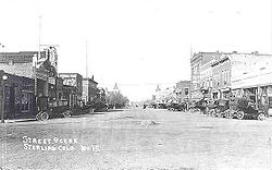
Historic Pictures
External links
- City of Sterling website
- Northeastern Junior College
- Sterling Journal-Advocate (local newspaper website)
- Sterling at City-Data.com
- Stephen Harriman LongStephen Harriman LongStephen Harriman Long was a U.S. army explorer, topographical engineer, and railway engineer. As an inventor, he is noted for his developments in the design of steam locomotives. He was also one of the most prolific explorers of the early 1800s, although his career as an explorer was relatively...
- Historical account of travel on the Overland Trail
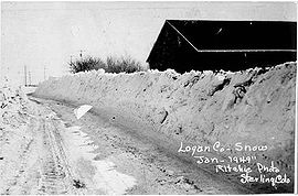
- Blizzard of '49
- Willa Cather short story "The Affair at Grover Station" about stempler, Colorado
- Video welcome to Sterling
- Sterling Quality of Life
- Economic Opportunities in Sterling, Colorado