
Col du Lautaret
Encyclopedia
Mountain pass
A mountain pass is a route through a mountain range or over a ridge. If following the lowest possible route, a pass is locally the highest point on that route...
in the department of Hautes-Alpes
Hautes-Alpes
Hautes-Alpes is a department in southeastern France named after the Alps mountain range.- History :Hautes-Alpes is one of the original 83 departments created during the French Revolution on 4 March 1790...
in France
France
The French Republic , The French Republic , The French Republic , (commonly known as France , is a unitary semi-presidential republic in Western Europe with several overseas territories and islands located on other continents and in the Indian, Pacific, and Atlantic oceans. Metropolitan France...
.
It marks the boundary between the valleys of the Romanche
Romanche
The Romanche is a 78 km long mountain river in southeastern France, right tributary of the Drac . Its source is in the northern part of the Massif des Écrins, Dauphiné Alps. It flows into the Drac in Champ-sur-Drac, south of Grenoble. The road from Grenoble to Briançon over the Col du Lautaret runs...
and the Guisane, a tributary
Tributary
A tributary or affluent is a stream or river that flows into a main stem river or a lake. A tributary does not flow directly into a sea or ocean...
of the Durance
Durance
The Durance is a major river in south-eastern France.Its source is in the south-western Alps, in Montgenèvre ski resort near Briançon and it flows south-west through the following départements and cities:* Hautes-Alpes: Briançon, Embrun.* Alpes-de-Haute-Provence: Sisteron, Manosque.* Vaucluse:...
which has its source at the col. The valleys are linked by national route 91
Route nationale (France)
A route nationale, or simply nationale, is a trunk road in France. Trunk roads are in France are important roads which cross broad portions of the French territory, as opposed to secondary or communal roads who only serve local areas....
(Grenoble
Grenoble
Grenoble is a city in southeastern France, at the foot of the French Alps where the river Drac joins the Isère. Located in the Rhône-Alpes region, Grenoble is the capital of the department of Isère...
– Le Bourg-d'Oisans
Le Bourg-d'Oisans
Le Bourg-d'Oisans is a commune in the Isère department in south-eastern France.It is located in the Oisans region of the French Alps. Le Bourg-d'Oisans is located in the valley of the Romanche river, on the road from Grenoble to Briançon, and on the south side of the Col de la Croix de Fer...
– Briançon
Briançon
Briançon a commune in the Hautes-Alpes department in the Provence-Alpes-Côte d'Azur region in southeastern France. It is a sub-prefecture of the department....
). The Lautaret is one of the lowest points on the ridge line which separates the "north" (mainly in the Rhône-Alpes
Rhône-Alpes
Rhône-Alpes is one of the 27 regions of France, located on the eastern border of the country, towards the south. The region was named after the Rhône River and the Alps mountain range. Its capital, Lyon, is the second-largest metropolitan area in France after Paris...
région) and "south" (mainly in the Provence-Alpes-Côte d'Azur région) geographic areas of the French Alps
Alps
The Alps is one of the great mountain range systems of Europe, stretching from Austria and Slovenia in the east through Italy, Switzerland, Liechtenstein and Germany to France in the west....
.
The col was modeled by a glacier
Glacier
A glacier is a large persistent body of ice that forms where the accumulation of snow exceeds its ablation over many years, often centuries. At least 0.1 km² in area and 50 m thick, but often much larger, a glacier slowly deforms and flows due to stresses induced by its weight...
which flowed down either side into the two valleys, and this explains the relatively easy gradient of the slopes by which it is attained. For the latter reason, the Col has long been used as a communication route between Grenoble and Briançon, and indeed for reaching Italy
Italy
Italy , officially the Italian Republic languages]] under the European Charter for Regional or Minority Languages. In each of these, Italy's official name is as follows:;;;;;;;;), is a unitary parliamentary republic in South-Central Europe. To the north it borders France, Switzerland, Austria and...
across the Alps.
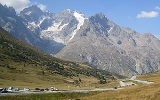
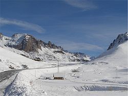
The Col is open all year round and provides good views of La Meije
Meije
La Meije is a mountain in the Massif des Écrins range, located at the border of the Hautes-Alpes and Isère départements. It overlooks the nearby village of La Grave, a mountaineering centre and ski resort, well-known for its off-piste and extreme skiing possibilities.La Meije is composed of three...
to the south-west and the Grand Galibier to the north. It is also well-known for its botanical garden
Botanical garden
A botanical garden The terms botanic and botanical, and garden or gardens are used more-or-less interchangeably, although the word botanic is generally reserved for the earlier, more traditional gardens. is a well-tended area displaying a wide range of plants labelled with their botanical names...
, and for its use in the Tour de France
Tour de France
The Tour de France is an annual bicycle race held in France and nearby countries. First staged in 1903, the race covers more than and lasts three weeks. As the best known and most prestigious of cycling's three "Grand Tours", the Tour de France attracts riders and teams from around the world. The...
. The route to the south side of the Col du Galibier
Col du Galibier
Col du Galibier is a mountain pass in the southern region of the French Dauphiné Alps near Grenoble. It is the ninth highest paved road in the Alps and the sixth highest mountain pass. It is often the highest point of the Tour de France....
leaves from the Lautaret.
See also
- List of highest paved roads in Europe
- List of mountain passes