

Durance
Encyclopedia
The Durance is a major river
in south-eastern France
.
Its source is in the south-western Alps
, in Montgenèvre
ski resort near Briançon
and it flows south-west through the following départements and cities:
The Durance's main tributaries
are the Bléone
and Verdon
rivers. The Durance itself is a tributary of the Rhone River
and flows into the Rhone near Avignon
.
as and in Latin
as (1st century), (854, 1271) and (1127). The traditional forms are probably derivatives of *Dūrantia, based on the Celtic "dour" (water) and suffix "ant" (stream). The Latin form ("hard") changed into the Old French "dur". Similar names are found in the names of many rivers in the Western Alps: Dora
in Italy, Dranse
in Haute-Savoie
, and the Drôme
in south-eastern France. All these rivers have their sources in mountains, and are fast-running.
The Durance flows more slowly than the Clarée
or Guisane, even though they are further downstream. The Durance is better known than the other two because the Durance valley is an old and important trade route, whereas those of Clarée and Guisane are dead ends.
The Durance is 305 kilometres (189.5 mi) long from its source at the foot of Sommet des Anges, at 2390 metres (7,841.2 ft) high, beneath Montgenèvre
, to its confluence
with the Rhône. However, a longer route is traced by the Clarée-Durance system with a length of 325 kilometres (201.9 mi). Its descent is unusually rapid at 81 m/km (165 ft/mi) in its first 12 km (7.5 mi), then 15 m/km (30 ft/mi) to its confluence with the Gyronde, and then still nearly 8 m/km (16 ft/mi) to the confluence with the Ubaye. This descent stays relatively steep after this confluence, then shallows to approximately 0.33% in its middle course (to the Mirabeau
bridge), then 0.24% in its lower course. For comparison, at approximately 100 kilometres (62.1 mi) from its source, the Isère
is at 330 metres (1,082.7 ft) altitude and the Durance at 700 metres (2,296.6 ft), which contributes partially to its fast-flowing nature, including in the lower part of the river. It drops 1847 metres (6,059.7 ft) from its source to Mirabeau and approximately 2090 metres (6,857 ft) from its source to the confluence with the Rhône
.
— built where the banks are very steep — the other towns are built on slopes close to the river:
The Durance catchment area extends to three other departments: Var, Drôme
and Alpes-Maritimes
.
, an artificial lake with a hydroelectric
dam, the Durance flows through a broad valley surrounded by the high Pelvoux
mountain range. It is an Alpine river, strongest after the snow melts in the spring, with its highest level in June and a sustained flow even in summer. The mountain stream of Montgenèvre flows into the Clarée, crosses Briançon then the Guisane flows into it. It then moves south where the waters of the Gyronde also flow into it — the Écrans glacial stream — in L'Argentière-la-Bessée
. Its course veers south-south-east until its confluence with the Guil below Guillestre
and Mont-Dauphin
, then backs south-south-west and flows into the Lac de Serre-Ponçon a little downstream of Embrun. The confluence with the Ubaye was flooded as the lake filled.
around a trench of a few metres to some tens of metres deep. Here, the nature of the Durance becomes Mediterranean: floods caused by the autumnal rains, with severely low water levels in summer. Just before the water gap
of Sisteron, the Durance joins Buëch
, which takes water from the EDF Canal
. Many minor streams also flow close to Sisteron (Sifts, Jabron, Vançon). Upstream the Durance is surrounded by hills and plains, but the valley widens into an alluvial plain several kilometres wide (5 kilometres (3.1 mi) in Manosque
), and the river was recently diverted for the development of modern agriculture and the construction of the A51 motorway.
The river receives the waters of Bléone
near Les Mées
and from the Adze
a few kilometres to the south of Oraison
. The Verdon
flows into the Durance near Cadarache
: this junction is difficult to see unless viewed from above. Several stopping-places were built along the middle part of the Durance, in addition to Serre-Ponçon: Espinasses
, Sisteron, L'Escale
(which means "the stopover") and Cadarache
. There are more small canals whose primary purpose is to draw water from the river into the EDF Canal which feeds the hydroelectric power stations; the lakes which they create cannot be used to control the course of the river. Some of the water is used for irrigation.
and Luberon
). The Durance receives only one significant tributary on this last part of its course: the Calavon
(also called le Coulon), which circumvents the Lubéron range by the north.
left bank tributary; (D) right bank tributary; (MR) main river, the name given to part of the water course taken into account in the calculation of its total length.
, salmon
used to thrive, and trout
were found up until Sisteron, before the development of the river.
it is 123m³/s and after receipt of the Verdon, flow reaches 174 m³/s (250 to 330 m³/s in spring, 100 m³/s in the summer). The contribution of water from the tributaries downstream is very low. The annual maximum generally occurs in May or June, but the most violent flash floods occur in autumn. The low water level occurs in winter in the upper valley, and in summer in the middle and lower part of the river.
of the Durance ranges from land with year-round snow, to hills and plateaus with a Mediterranean climate
. Thus, the river is subjected to a snow regime in its upper part (up to Serre-Ponçon), with winter low water levels and floods each year from May to July. At Serre-Ponçon, there is a watershed of 3600 km², a low water level of 83.3 m³/s, with a low flow of 18 m³/s, and a maximum flood of 1700 m³/s (value recorded in 1957).
Further downstream, its many tributaries of the uplands, or Mediterranean plateaus, primarily bring rain water in winter, in spring and during the floods of autumn, with a low and very irregular flow in summer. The result is a shift of the maximum natural spring, from June to May, down the river.
Between 1832 and 1890, the Durance had 188 water rises of more than 3 metres (measured with the bridge of Mirabeau). That of 1843 carried several newly-built suspension bridges (those of Remollon, going back to 1829, of Mirabeau, built in 1835, of Manosque, unfinished, of Les Mées, going back to 1838). The flood of 1872 still carried the bridge of Mallemort (1847).
These floods millénales (three in the 19th century: 1843, 1856, 1886) reach 5000 with 6000 m³/s, according to the auteurs;
for comparison, the Seine
flooding of 1910 reached approximately 2400 m³/s with its more extremely. In the 19th century, the principal floods are those of 1843, 1856 (which flooded Avignon) and 1886.
And even of raw less important can be devastating: that of 31 May and 1 June 1877 carried the bridge of Tallard
.
In the 20th century, the floods were less frequent and violent thanks to the afforestation of the catchment area, but one still observed important ones in 1957 and 1994 (3000 m³/s). These maxima are raised in Mirabeau; in Sisteron, the floods can have a flow of 2800 m³/s; with the confluence with the Verdon, the flow can reach 500 m³/s.
The importance of these floods is due to a very important streaming: the height of the water blade run out in Cadarache east of 472 mm, for an average of 750 mm precipitations: 63% of the rains stream and lead in Durance.
Previously, the Durance had carried the town of Rama
(between Briançon and Embrun, with the confluence of Biaisse) in the 12th century.
At Mirabeau, the low water level is 45 m³ /s, that is to say a variation from 1 to 133; at the time of the dryness of 1921, which lasts until December, the flow goes down up to 27 m³/s.
the started to be built during the Middle Ages. They are often boxes of wood filled up of stones, which do not resist the floods a long time. In another direction, since the same time, one uses the water of the Durance to irrigate the close grounds, then to feed out of water all Provence. The first known canal is the canal Saint-Julien, dug in 1171 by the marquis de Forbin. It was followed by the Adam de Craponne
canal (50 km dug in nine months in 1554 from Silvacane to Arles
), the canal des Alpilles, the canal de Marseille
, the canal de Carpentras, the canal de Manosque, the canal de Ventavon, and the hundreds of other smaller ones, totalling 540 km dug between the end of the 16th century and the end of the 19th century.
with drinking water. The canal follows a layout of 80 km in length of which 17 km is underground and traverses the Bouches-du-Rhône
. The canal is made out of concrete, the air works out of stones or stones and bricks. Flow of the work is 10 m³ /s, the slope of 0.36 m/km. The width at the top is 9.4m, the width of the basin 3m.
The catch initial water was located on the Durance at the level of the bridge of Pertuis
, at an altitude of 185 metres, and with 50 kilometres with flight bird of Marseilles. From there the channel left towards thewest under theHolyone. During the construction of the large EDF canal, which doubles the Durance from Serre-Ponçon
until Salon-de-Provence
and the Étang de Berre
, the catch water of the canal of Marseilles was deferred on the EDF canal itself, after Saint-Estève-Janson
. From there the canal of Marseilles continues towards the North-West with the bridge of Cadenet
, where it supplies the basin of Saint-Christophe. The Durance still provides today two-thirds of the water resource of the town of Marseilles.
. Within this framework, three missions are entrusted at EDF:
This program involved, over one 40 years period, the construction of 23 stoppings and hydrants (hydrants upstream of Claux on Argentière with that of Mallemort while passing by the stopping of Serre-Ponçon), channel EDF of the Durance, feeding 33 hydroelectric stations, and several control stations.
This program is an almost complete success:
, its principal affluent).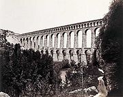
and the Pan-European ecological network
frameworks, which explains its classification as a Natura 2000
protected area.
Currently there are between 150 and 200 species of benthic macroinvertebrates, but with few plant species (due to the oligotrophic and hydrologically dynamic nature of the river).
Water quality is considered good in the higher valley, in spite of inevitable filling with many reserves, which deprive the Durance of the power necessary to carry the sediments. This quality was obtained thanks to actions of cleansing (including on the affluents of the Luye and Calavon (also called le Coulon)). There remain some black spots in the valley (downstream from the Arkema
factory in Château-Arnoux
, after the junction with the Calavon.
The 320 millimetres (12.6 in) depth variation results in significant temperature variations, varying seasonally (from 0 to 28°C) and daily(7.5°C of amplitude the summer, 10°C the winter), and is a significant factor in the biodiversity of the river. The installation of the valley and the spacing and reduction in the importance of the floods allowed the colonization of alluvial space by one ripisylve of alder
S and of poplar
S which constitutes one locally gallery-forest. The bed, although less wet, accommodates 110 more species of birds during the year, plus 82 species of migratory birds which find there zones of rest and nourishment, and sometimes of reproduction. 110 species hibernate there. Avian diversity increased after installations, but it is probable there was formerly a diversity higher than this, the same number individuals higher for certain families of birds.
There are approximately 75 species of mammals in the Durance catchment, including: Europe beaver, amphibious field vole, crossope (or watery shrew), many species of bat (barbastelle (Barbastella barbastellus, large murine (Myotis myotis), large rhinolophe (Rhinolophus ferrumequinum), minioptère of Schreibers (Miniopterus schreibersi), small murine (Myotis blythii), small rhinolophe (Rhinolophus hipposideros), vespertilion with indented ears (Myotis emarginatus), and vespertilion of Capaccini (Myotis capaccinii)). Invasive species are becoming more problematic invasive
(including coypu
and muskrat
more recently arrived). Otter
are potentially locally extirpated from sections, or indeed have become extinct in the entire catchmen. The populations of algae
and water plants (100 species on average) and water invertebrates (77 species) are varied than before installations (comparison with those of the Adze (Alp-of-High-Provence)
and of Buëch). Jussy, an invasive plant, has gradually appeared (since 1986) in the stagnant water (dead gravel pits, pond, arms).
There are in the same way few fish species (14), but some patrimonial species; in addition to blageon and toxostome, one also finds large populations of Zingel asper
and loach
(Cobitis taenia taenia) (both endangered species
of fish). But the silting and the lack of oxygen compromise the reproduction of the truites. The Brook lamprey
was still recently seen there. Perhaps it has disappeared.
, and largely contributed to the economic growth and demographic of the Marseilles area, after having been an obstacle for centuries. From Antiquity
until the 19th century, the Durance was famous for its difficult crossing, its brutal floods and an inconstant flow. The width of its bed, the force and low depth of its current, and the changes of course after the floods returned there crossing by ford or ferry, as well as the very difficult river navigation (in spite of a relatively important water in periods of high-water). One needed sometimes several ferries to cross the various arms or channels, to frequently rebuild the cable ("flying bridge") support, and the unstable and sometimes abrupt banks returned the establishment of the ferry and its difficult access. The fords were difficult to establish, often carried: the only durable ones are those of Mirabeau and Pertuis, unusable in periods of crues.
(Cavaillon
) and the Salyes
(Bouches-du-Rhône
).
Strabon (1st century) signaled that a ferry was established in Cavaillon
, the great Roman way of Spain in Italy not crossing the Durance between Cavaillon and the Mount-Genèvre. That a bridge existed in Sisteron is known. Other ferries were allowed to cross it, in particular with the height of Pertuis
, city whose name preserves the memory of this function. Difficult to cross (except in Sisteron, where its course is tightened between two rock banks), the Durance is nevertheless navigable. Low-relief the S of Cabrières-d'Aigues
show it, the river is used for the transport of various liquid food products (wine, olive oil), Gallo-Romans used the boat-towers and wind to go up the current. Several specialized corporations ensured this transport: nautes had to monopoly
transport on large rivers and used boats, the utricular which had it on the small rivers and in the marshes used rafts floating on inflated goatskin bottles. Two corporations the utricular ones were in Sisteron and Riez.
This trade fed the activity of an important port, near to the road crossroads of Sisteron, at the place called Le Bourguet, in L'Escale
: the port existed before the Roman conquest, but was developed during the 1st century BC, was prosperous until the Crisis of the Third Century
, before finding an economic activity until the beginning of the 5th century.
The valley of the Durance is a route of penetration of the Alps, borrowed by the Via Domitia
. A statue of Janus
rises high beside in Montgenèvre, not passage between Cisalpine Gaul
and it Gallia Narbonensis
stretched all along the Durance, from Cavaillon to La Roche-de-Rame
, close to Embrun
. From the 12th to the 19th century, the river was employed with flotation of wood, crossed in the Alps (in particular by the monks of Boscodon, which by privilege of 1191 used the river.) and used in the towns of plain and the shipyards.
Other goods were transferred on the river, including mainly salt, goods which see their price increased by the ten tolls established out of the 300 km of the river.
The bridge of Sisteron, erected in the Middle Ages, remained, to the middle of the 19th century, the only passage into a hard bank across the Durance. After the year Millet, the number of ferries (already present before) increases however: it is about trail ferries (equipped with a mast which are pressed on a cable, the flying bridge, tended between two banks of the principal course). The oldest known one was the one between La Roque-d'Anthéron
and Cadenet
(in Gontard), attested in 1037. In the 16th century, that of Pertuis
still existed. Thereafter, the evidence of existence of ferries multiplies, in particular with Rognonas
, La Brillanne
(13th century), Noves
, Orgon
, Le Puy-Sainte-Réparade
, Meyrargues
, Pertuis
, Peyrolles
, that of Cante-Perdrix in Mirabeau
, Manosque
, Giropey, Château-Arnoux, Le Bourguet
, Volonne
, Bompas. The principal ones are those of Cadenet and Mirabeau, which were borrowed by the herds of sheep for transhumance
. Other ferries are installed to supply the mills built at the end of the 18th century in Poët
, with Upaix
and Claret
. Nevertheless, the service road by ferry remains increasingly weaker than that of the Rhone (a ferry each 9–11 km on average, against every 5.2 km on the Rhone). Starting from the 12th century, wood bridges were also built, which lasted more or less a long time, and were destroyed in various ways:
. It carries the cultivated alluvial terraces, breaks the dams, and destroys the canals.
The trade unions of sprinkling (which replaced the pareries) and the local services of the Bridges and Chaussées request an exceptional intervention from the State. The first service of observation of a river is created, the Special service of Durance, in order to study the hydrology of the river, follow-up of the kilometric demarcation of the river as from 1868, the confluence with the Verdon with that with the Rhone. This demarcation allows one levelling
and to chart the grounds inondables. The construction of the Marseilles canal in the middle of the 19th century allowed the Marseilles urban agglomeration to develop very quickly.
. There remained only 10 raftmen in 1896, one in 1908.
Hydroelectric installations, with the construction of the chain of locks on the Durance, the Verdon like on Buëch and Bléone, had the most significant economic impacts and most visible in the landscape. The major part of the flow was diverted in channels downstream from Serre-Ponçon, and only in the natural bed a reserved flow of 2 with circulates 5m³/s, corresponding to 1/40 of the natural flow. The bed is gradually fixed and vegetation starts to push there, where the water does not run any more. Thanks to the tanks of Serre-Ponçon and Holy-Crosses, which can retain a total of more than 2 billion tons of water, irrigation remains possible in summer during the driest years. The water levels allowed development of the local economy thanks to the summer tourism.
Beginning in the 1950s, very hard aggregate
was extracted from the river bed to be used for road surfacing and resistant concretes. The majority of the quarries are now in the process of closing. The few factories using the river's energy have closed (an aluminium factory at L'Argentière-la-Bessée) or are being closed (Arkema at Saint-Auban).
, built between 1862 and 1869 by the architect Espérandieu, in order to celebrate the arrival of water from the Durance into the city, via the Canal de Marseille
.
It is also carved under the features of a woman to the fertile belly, in Charleval, Bouches-du-Rhône
.
References in literature:
River
A river is a natural watercourse, usually freshwater, flowing towards an ocean, a lake, a sea, or another river. In a few cases, a river simply flows into the ground or dries up completely before reaching another body of water. Small rivers may also be called by several other names, including...
in south-eastern France
France
The French Republic , The French Republic , The French Republic , (commonly known as France , is a unitary semi-presidential republic in Western Europe with several overseas territories and islands located on other continents and in the Indian, Pacific, and Atlantic oceans. Metropolitan France...
.
Its source is in the south-western Alps
Alps
The Alps is one of the great mountain range systems of Europe, stretching from Austria and Slovenia in the east through Italy, Switzerland, Liechtenstein and Germany to France in the west....
, in Montgenèvre
Montgenèvre
Montgenèvre is a commune of the Hautes-Alpes department in southeastern France.-Geography:Montgenèvre is located in the French Cottian Alps. It is on the Franco-Italian border at the top of the Col de Montgenèvre....
ski resort near Briançon
Briançon
Briançon a commune in the Hautes-Alpes department in the Provence-Alpes-Côte d'Azur region in southeastern France. It is a sub-prefecture of the department....
and it flows south-west through the following départements and cities:
- Hautes-AlpesHautes-AlpesHautes-Alpes is a department in southeastern France named after the Alps mountain range.- History :Hautes-Alpes is one of the original 83 departments created during the French Revolution on 4 March 1790...
: BriançonBriançonBriançon a commune in the Hautes-Alpes department in the Provence-Alpes-Côte d'Azur region in southeastern France. It is a sub-prefecture of the department....
, EmbrunEmbrun, Hautes-AlpesEmbrun is a commune in the Hautes-Alpes department in the Provence-Alpes-Côte d'Azur region in southeastern France.-Description:...
. - Alpes-de-Haute-ProvenceAlpes-de-Haute-ProvenceAlpes-de-Haute-Provence is a French department in the south of France, it was formerly part of the province of Provence.- History :Nord-de-Provence was one of the 83 original departments created during the French Revolution on 4 March 1790...
: SisteronSisteronSisteron is a commune in the Alpes-de-Haute-Provence department in the Provence-Alpes-Côte d'Azur region in southeastern France.Sisteron is situated on the banks of the River Durance just after the confluence of the rivers Buëch and Sasse...
, ManosqueManosqueManosque is the largest town and commune in the Alpes-de-Haute-Provence department in southeastern France. However, it is not the préfecture of the département, which resides in the smaller town of Digne-les-Bains...
. - VaucluseVaucluseThe Vaucluse is a department in the southeast of France, named after the famous spring, the Fontaine-de-Vaucluse.- History :Vaucluse was created on 12 August 1793 out of parts of the departments of Bouches-du-Rhône, Drôme, and Basses-Alpes...
: CavaillonCavaillonCavaillon is a commune in the Vaucluse department in the Provence-Alpes-Côte d'Azur region in southeastern France.-Geography:The Calavon, a tributary of the Durance locally called Coulon, flows westward through the middle of the commune....
, AvignonAvignonAvignon is a French commune in southeastern France in the départment of the Vaucluse bordered by the left bank of the Rhône river. Of the 94,787 inhabitants of the city on 1 January 2010, 12 000 live in the ancient town centre surrounded by its medieval ramparts.Often referred to as the...
. - Bouches-du-RhôneBouches-du-RhôneBouches-du-Rhône is a department in the south of France named after the mouth of the Rhône River. It is the most populous department of the Provence-Alpes-Côte d'Azur region. Its INSEE and postal code is 13.-History of the department:...
.
The Durance's main tributaries
Tributary
A tributary or affluent is a stream or river that flows into a main stem river or a lake. A tributary does not flow directly into a sea or ocean...
are the Bléone
Bléone
The Bléone is a long river in the Alpes-de-Haute-Provence département, southeastern France. Its source is several small streams converging near the refuge de l'Estrop, a mountain shelter in Prads-Haute-Bléone. It flows generally southwest...
and Verdon
Verdon River
The Verdon is a 166 km long river in south-eastern France, left tributary of the Durance. Its source is at an altitude of 2819 m, in the south-western Alps , between the col d'Allos and the Trois Eveches mountain, south of Barcelonnette...
rivers. The Durance itself is a tributary of the Rhone River
Rhône River
The Rhone is one of the major rivers of Europe, rising in Switzerland and running from there through southeastern France. At Arles, near its mouth on the Mediterranean Sea, the river divides into two branches, known as the Great Rhone and the Little Rhone...
and flows into the Rhone near Avignon
Avignon
Avignon is a French commune in southeastern France in the départment of the Vaucluse bordered by the left bank of the Rhône river. Of the 94,787 inhabitants of the city on 1 January 2010, 12 000 live in the ancient town centre surrounded by its medieval ramparts.Often referred to as the...
.
Etymology
The Durance is documented in Ancient GreekAncient Greek
Ancient Greek is the stage of the Greek language in the periods spanning the times c. 9th–6th centuries BC, , c. 5th–4th centuries BC , and the c. 3rd century BC – 6th century AD of ancient Greece and the ancient world; being predated in the 2nd millennium BC by Mycenaean Greek...
as and in Latin
Latin
Latin is an Italic language originally spoken in Latium and Ancient Rome. It, along with most European languages, is a descendant of the ancient Proto-Indo-European language. Although it is considered a dead language, a number of scholars and members of the Christian clergy speak it fluently, and...
as (1st century), (854, 1271) and (1127). The traditional forms are probably derivatives of *Dūrantia, based on the Celtic "dour" (water) and suffix "ant" (stream). The Latin form ("hard") changed into the Old French "dur". Similar names are found in the names of many rivers in the Western Alps: Dora
Dora Riparia
The Dora Riparia is an Italian river, a left-hand tributary of the Po. It is 125 km long, with a 1,231 km² drainage basin. It originates in the Cottian Alps, close to the Col de Montgenèvre in France, where it is called the Piccola Dora...
in Italy, Dranse
Dranse (Haute-Savoie)
The Dranse is a French river in the department of Haute-Savoie, that empties into Lake Geneva.The name "Dranse" comes from the former Drantia, based on the hydronym dur-, dora and the suffix -antia.-Geography:...
in Haute-Savoie
Haute-Savoie
Haute-Savoie is a French department in the Rhône-Alpes region of eastern France. It borders both Switzerland and Italy. The capital is Annecy. To the north is Lake Geneva and Switzerland; to the south and southeast are the Mont Blanc and Aravis mountain ranges and the French entrance to the Mont...
, and the Drôme
Drôme River
The Drôme , a river in southeastern France, has a length of 110 km long and forms a left tributary of the Rhône River. Its source is in the western foothills of the Alps, near the village Valdrôme...
in south-eastern France. All these rivers have their sources in mountains, and are fast-running.
The Durance flows more slowly than the Clarée
Clarée
The Clarée is a river in southeastern France, a tributary to the Durance. Its source is in the Cottian Alps, near the Mont Thabor and Valloire. It flows for all of its course in the Hautes-Alpes département...
or Guisane, even though they are further downstream. The Durance is better known than the other two because the Durance valley is an old and important trade route, whereas those of Clarée and Guisane are dead ends.
Hydrography
The Durance is 305 kilometres (189.5 mi) long from its source at the foot of Sommet des Anges, at 2390 metres (7,841.2 ft) high, beneath Montgenèvre
Montgenèvre
Montgenèvre is a commune of the Hautes-Alpes department in southeastern France.-Geography:Montgenèvre is located in the French Cottian Alps. It is on the Franco-Italian border at the top of the Col de Montgenèvre....
, to its confluence
Confluence
Confluence, in geography, describes the meeting of two or more bodies of water.Confluence may also refer to:* Confluence , a property of term rewriting systems...
with the Rhône. However, a longer route is traced by the Clarée-Durance system with a length of 325 kilometres (201.9 mi). Its descent is unusually rapid at 81 m/km (165 ft/mi) in its first 12 km (7.5 mi), then 15 m/km (30 ft/mi) to its confluence with the Gyronde, and then still nearly 8 m/km (16 ft/mi) to the confluence with the Ubaye. This descent stays relatively steep after this confluence, then shallows to approximately 0.33% in its middle course (to the Mirabeau
Mirabeau, Vaucluse
Mirabeau is a commune in the Vaucluse department in the Provence-Alpes-Côte d'Azur region in southeastern France.It has several buildings from the thirteenth century in the centre, including the Chapel de Madelinne -References:*...
bridge), then 0.24% in its lower course. For comparison, at approximately 100 kilometres (62.1 mi) from its source, the Isère
Isère River
The Isère is a 286 km long river in southeastern France, in the Rhône-Alpes région. Its source is in the Alps on the border with Italy, near the ski resort Val d'Isère. It flows into the Rhône River in Pont-de-l'Isère, a few km north of Valence...
is at 330 metres (1,082.7 ft) altitude and the Durance at 700 metres (2,296.6 ft), which contributes partially to its fast-flowing nature, including in the lower part of the river. It drops 1847 metres (6,059.7 ft) from its source to Mirabeau and approximately 2090 metres (6,857 ft) from its source to the confluence with the Rhône
Rhône
Rhone can refer to:* Rhone, one of the major rivers of Europe, running through Switzerland and France* Rhône Glacier, the source of the Rhone River and one of the primary contributors to Lake Geneva in the far eastern end of the canton of Valais in Switzerland...
.
Departments and main towns crossed
The river only runs through the towns of Briançon and SisteronSisteron
Sisteron is a commune in the Alpes-de-Haute-Provence department in the Provence-Alpes-Côte d'Azur region in southeastern France.Sisteron is situated on the banks of the River Durance just after the confluence of the rivers Buëch and Sasse...
— built where the banks are very steep — the other towns are built on slopes close to the river:
- Hautes-AlpesHautes-AlpesHautes-Alpes is a department in southeastern France named after the Alps mountain range.- History :Hautes-Alpes is one of the original 83 departments created during the French Revolution on 4 March 1790...
: BriançonBriançonBriançon a commune in the Hautes-Alpes department in the Provence-Alpes-Côte d'Azur region in southeastern France. It is a sub-prefecture of the department....
, EmbrunEmbrun, Hautes-AlpesEmbrun is a commune in the Hautes-Alpes department in the Provence-Alpes-Côte d'Azur region in southeastern France.-Description:...
; - Alpes-de-Haute-ProvenceAlpes-de-Haute-ProvenceAlpes-de-Haute-Provence is a French department in the south of France, it was formerly part of the province of Provence.- History :Nord-de-Provence was one of the 83 original departments created during the French Revolution on 4 March 1790...
: SisteronSisteronSisteron is a commune in the Alpes-de-Haute-Provence department in the Provence-Alpes-Côte d'Azur region in southeastern France.Sisteron is situated on the banks of the River Durance just after the confluence of the rivers Buëch and Sasse...
, Château-Arnoux-Saint-AubanChâteau-Arnoux-Saint-AubanChâteau-Arnoux-Saint-Auban is a commune in the department of Alpes-de-Haute-Provence in the region of Provence-Alpes-Côte d'Azur in southeastern France.-Population:Its inhabitants are referred to as Jarlandins.-Places of interest:...
; - VaucluseVaucluseThe Vaucluse is a department in the southeast of France, named after the famous spring, the Fontaine-de-Vaucluse.- History :Vaucluse was created on 12 August 1793 out of parts of the departments of Bouches-du-Rhône, Drôme, and Basses-Alpes...
: PertuisPertuisPertuis is a commune in the Vaucluse department in the Provence-Alpes-Côte d'Azur region in southeastern France.Located south of the Luberon, this town is also near Aix-en-Provence, a famous town. Pertuis has existed since at least 981, while a castle was first built in the 12th century...
, CadenetCadenetCadenet is a commune in the Vaucluse department in the Provence-Alpes-Côte d'Azur region in southeastern France.-Jewish community:Like all places situated along the river Durance, Cadenet had a Jewish community in the Middle Ages...
, CavaillonCavaillonCavaillon is a commune in the Vaucluse department in the Provence-Alpes-Côte d'Azur region in southeastern France.-Geography:The Calavon, a tributary of the Durance locally called Coulon, flows westward through the middle of the commune....
; - Bouches-du-RhôneBouches-du-RhôneBouches-du-Rhône is a department in the south of France named after the mouth of the Rhône River. It is the most populous department of the Provence-Alpes-Côte d'Azur region. Its INSEE and postal code is 13.-History of the department:...
, left bank of the Durance.
The Durance catchment area extends to three other departments: Var, Drôme
Drôme
Drôme , a department in southeastern France, takes its name from the Drôme River.-History:The French National Constituent Assembly set up Drôme as one of the original 83 departments of France on March 4, 1790, during the French Revolution...
and Alpes-Maritimes
Alpes-Maritimes
Alpes-Maritimes is a department in the extreme southeast corner of France.- History : was created by Octavian as a Roman military district in 14 BC, and became a full Roman province in the middle of the 1st century with its capital first at Cemenelum and subsequently at Embrun...
.
Start of the river: source to Serre-Ponçon
Until the Lac de Serre-PonçonLac de Serre-Ponçon
Lake Serre-Ponçon is a lake in southeast France; it is one of the largest artificial lakes in western Europe. The lake gathers the waters of the Durance and the Ubaye rivers, flowing down through the Hautes-Alpes and the Alpes du Sud to the Rhône River...
, an artificial lake with a hydroelectric
Hydroelectricity
Hydroelectricity is the term referring to electricity generated by hydropower; the production of electrical power through the use of the gravitational force of falling or flowing water. It is the most widely used form of renewable energy...
dam, the Durance flows through a broad valley surrounded by the high Pelvoux
Pelvoux
Pelvoux is a commune in the Hautes-Alpes department in the Provence-Alpes-Côte d'Azur region in southeastern France.Pelvoux was bidding to be the French candidate city for the 2018 Winter Olympics.-Population:-External links:* *...
mountain range. It is an Alpine river, strongest after the snow melts in the spring, with its highest level in June and a sustained flow even in summer. The mountain stream of Montgenèvre flows into the Clarée, crosses Briançon then the Guisane flows into it. It then moves south where the waters of the Gyronde also flow into it — the Écrans glacial stream — in L'Argentière-la-Bessée
L'Argentière-la-Bessée
L'Argentière-la-Bessée is a commune of the Hautes-Alpes department in the Alps in southeastern France.The town lies on the River Durance, which is used for kayaking, white-water rafting and other water sports. The Argentiere Canoe Slalom Course is in the Durance River south of the town. The town...
. Its course veers south-south-east until its confluence with the Guil below Guillestre
Guillestre
Guillestre is a commune in the Hautes-Alpes department in southeastern France.-Geography:The village lies in the northwestern part of the commune, on the left bank of the Chagne, a stream, tributary of the Guil, which forms all of the commune's northern border, before flowing into the Durance,...
and Mont-Dauphin
Mont-Dauphin
Mont-Dauphin is a commune in the Hautes-Alpes department in southeastern France.At the confluence of Durance and Guil rivers, overlooking the impressive canyon of the latter flowing down from Queyras valley, Mont-Dauphin is one of the many places fortified by Vauban in the second half of the 17th...
, then backs south-south-west and flows into the Lac de Serre-Ponçon a little downstream of Embrun. The confluence with the Ubaye was flooded as the lake filled.
Middle section of the river: from Serre-Ponçon to the water gap of Mirabeau
The middle part of the Durance runs through a landscape that changes radically as the mountains draw aside and increasingly wider plains replace them. The river itself becomes steeply banked, carving through terracesStream terrace
Fluvial terraces are elongated terraces that flank the sides of floodplains and fluvial valleys all over the world. They consist of a relatively level strip of land, called a “tread,” separated from either an adjacent floodplain, other fluvial terraces, or uplands by distinctly steeper strips of...
around a trench of a few metres to some tens of metres deep. Here, the nature of the Durance becomes Mediterranean: floods caused by the autumnal rains, with severely low water levels in summer. Just before the water gap
Water gap
A water gap is an opening or notch which flowing water has carved through a mountain range. Water gaps often offer a practical route for road and rail transport to cross mountain ridges.- Geology :...
of Sisteron, the Durance joins Buëch
Buëch
The Buëch is a river in southeastern France, right tributary to the Durance. Its source is in the Dauphiné Alps, near the Grand Ferrand peak. It flows generally southward, for most of its course in the Hautes-Alpes département...
, which takes water from the EDF Canal
Électricité de France
Électricité de France S.A. is the second largest French utility company. Headquartered in Paris, France, with €65.2 billion in revenues in 2010, EDF operates a diverse portfolio of 120,000+ megawatts of generation capacity in Europe, Latin America, Asia, the Middle East and Africa.EDF is one of...
. Many minor streams also flow close to Sisteron (Sifts, Jabron, Vançon). Upstream the Durance is surrounded by hills and plains, but the valley widens into an alluvial plain several kilometres wide (5 kilometres (3.1 mi) in Manosque
Manosque
Manosque is the largest town and commune in the Alpes-de-Haute-Provence department in southeastern France. However, it is not the préfecture of the département, which resides in the smaller town of Digne-les-Bains...
), and the river was recently diverted for the development of modern agriculture and the construction of the A51 motorway.
The river receives the waters of Bléone
Bléone
The Bléone is a long river in the Alpes-de-Haute-Provence département, southeastern France. Its source is several small streams converging near the refuge de l'Estrop, a mountain shelter in Prads-Haute-Bléone. It flows generally southwest...
near Les Mées
Les Mées, Alpes-de-Haute-Provence
Les Mées is a commune in the Alpes-de-Haute-Provence department in southeastern France.-Geography:The Bléone forms the commune's northern border, then flows into the Durance, which forms the commune's western border.-Population:-References:*...
and from the Adze
Adze
An adze is a tool used for smoothing or carving rough-cut wood in hand woodworking. Generally, the user stands astride a board or log and swings the adze downwards towards his feet, chipping off pieces of wood, moving backwards as they go and leaving a relatively smooth surface behind...
a few kilometres to the south of Oraison
Oraison
Oraison is a commune in the Alpes-de-Haute-Provence department in southeastern France.-Geography:The river Asse forms all of the commune's southern border, then flows into the Durance, which forms all of its western border.-Population:-References:*...
. The Verdon
Verdon River
The Verdon is a 166 km long river in south-eastern France, left tributary of the Durance. Its source is at an altitude of 2819 m, in the south-western Alps , between the col d'Allos and the Trois Eveches mountain, south of Barcelonnette...
flows into the Durance near Cadarache
Cadarache
The CEA Cadarache facility is a French scientific research centre which specialises in nuclear energy research. It is located in the commune of Saint-Paul-lès-Durance, Bouches-du-Rhône, in the southern region of Provence-Alpes-Côte-d'Azur...
: this junction is difficult to see unless viewed from above. Several stopping-places were built along the middle part of the Durance, in addition to Serre-Ponçon: Espinasses
Espinasses
Espinasses is a commune in the Hautes-Alpes department in southeastern France.-Population:-References:*...
, Sisteron, L'Escale
L'Escale
L'Escale is a commune in the Alpes-de-Haute-Provence department in southeastern France.-Geography:The Bléone forms the commune's southern border, then flows into the Durance, which forms the commune's western border.-Population:-References:*...
(which means "the stopover") and Cadarache
Cadarache
The CEA Cadarache facility is a French scientific research centre which specialises in nuclear energy research. It is located in the commune of Saint-Paul-lès-Durance, Bouches-du-Rhône, in the southern region of Provence-Alpes-Côte-d'Azur...
. There are more small canals whose primary purpose is to draw water from the river into the EDF Canal which feeds the hydroelectric power stations; the lakes which they create cannot be used to control the course of the river. Some of the water is used for irrigation.
End of the river: Jouques to Avignon
The valley tightens for a few kilometres with the crossing of the Mirabeau water gap, at a depth of 200 metres (656.2 ft), then rewidens into an even broader plain until the confluence with the Rhone. Its orientation changes from north-south to east-west, like the small provençal mountain ranges between which it flows (AlpillesAlpilles
The Chaîne des Alpilles is a small range of mountains in Provence, southern France, located about south of Avignon at approximately .-Geography:The range is an extension of the much larger Luberon range...
and Luberon
Luberon
The Luberon or Luberon Massif , also called Lubéron, has a maximum altitude of 1,256 m and an area of about 600 km²...
). The Durance receives only one significant tributary on this last part of its course: the Calavon
Calavon
The Calavon is an long river in the Alpes-de-Haute-Provence and Vaucluse départements, southeastern France. Its source is near Banon. It flows generally west-southwest...
(also called le Coulon), which circumvents the Lubéron range by the north.
Summary of tributaries
Rivers longer than 20 kilometres (12.4 mi) that flow into the Durance, the branches are listed in order of their occurrence:
|
Ubaye The Ubaye is a river of southeastern France. It is 83 km long and flows through the Alpes-de-Haute-Provence department.Its rises at the Col de Longet, in the Cottian Alps on the border with Italy. It flows generally southwest, through Saint-Paul-sur-Ubaye, Jausiers and Barcelonnette... ; Buëch The Buëch is a river in southeastern France, right tributary to the Durance. Its source is in the Dauphiné Alps, near the Grand Ferrand peak. It flows generally southward, for most of its course in the Hautes-Alpes département... ; |
Bléone The Bléone is a long river in the Alpes-de-Haute-Provence département, southeastern France. Its source is several small streams converging near the refuge de l'Estrop, a mountain shelter in Prads-Haute-Bléone. It flows generally southwest... ; Largue Largue is a village in the Bittou Department of Boulgou Province in south-eastern Burkina Faso. As of 2005, the village has a population of 621.... ; Verdon River The Verdon is a 166 km long river in south-eastern France, left tributary of the Durance. Its source is at an altitude of 2819 m, in the south-western Alps , between the col d'Allos and the Trois Eveches mountain, south of Barcelonnette... ; Èze Èze is a commune in the Alpes-Maritimes département in southeastern France, not far from the city of Nice.-History:The area surrounding Èze was first populated around 2000 BC as a commune situated near Mount Bastide. The earliest occurrence of the name "Èze" can be found in the maritime books of... ; Calavon The Calavon is an long river in the Alpes-de-Haute-Provence and Vaucluse départements, southeastern France. Its source is near Banon. It flows generally west-southwest... (also called le Coulon) |
Hydrology
A river known as "capricious" and formerly dreaded due to its flash floods (it was called the third plague of Provence) as well as for its low water level, the Durance is at the same time an alpine and Mediterranean river with particular morphology. The High-Durance was an alpine river (flow ranging from 18 to 197m³/s). Its total drainage area is 14225 km². At the confluence with UbayeUbaye
The Ubaye is a river of southeastern France. It is 83 km long and flows through the Alpes-de-Haute-Provence department.Its rises at the Col de Longet, in the Cottian Alps on the border with Italy. It flows generally southwest, through Saint-Paul-sur-Ubaye, Jausiers and Barcelonnette...
, salmon
Salmon
Salmon is the common name for several species of fish in the family Salmonidae. Several other fish in the same family are called trout; the difference is often said to be that salmon migrate and trout are resident, but this distinction does not strictly hold true...
used to thrive, and trout
Trout
Trout is the name for a number of species of freshwater and saltwater fish belonging to the Salmoninae subfamily of the family Salmonidae. Salmon belong to the same family as trout. Most salmon species spend almost all their lives in salt water...
were found up until Sisteron, before the development of the river.
Flow
At the confluence with the Rhone, the average natural flow of the Durance is approximately 190m³/s, with a high annual variability. It can vary between 40 m³/s (the most severe low water levels) and 6000 m³/s (millennial floods), levels reached in 1843, 1882 and 1886. At the outlet into the Lac de Serre-Ponçon, the medium flow is 81m³/s; at the level of OraisonOraison
Oraison is a commune in the Alpes-de-Haute-Provence department in southeastern France.-Geography:The river Asse forms all of the commune's southern border, then flows into the Durance, which forms all of its western border.-Population:-References:*...
it is 123m³/s and after receipt of the Verdon, flow reaches 174 m³/s (250 to 330 m³/s in spring, 100 m³/s in the summer). The contribution of water from the tributaries downstream is very low. The annual maximum generally occurs in May or June, but the most violent flash floods occur in autumn. The low water level occurs in winter in the upper valley, and in summer in the middle and lower part of the river.
Mixed sources
The watershedDrainage basin
A drainage basin is an extent or an area of land where surface water from rain and melting snow or ice converges to a single point, usually the exit of the basin, where the waters join another waterbody, such as a river, lake, reservoir, estuary, wetland, sea, or ocean...
of the Durance ranges from land with year-round snow, to hills and plateaus with a Mediterranean climate
Mediterranean climate
A Mediterranean climate is the climate typical of most of the lands in the Mediterranean Basin, and is a particular variety of subtropical climate...
. Thus, the river is subjected to a snow regime in its upper part (up to Serre-Ponçon), with winter low water levels and floods each year from May to July. At Serre-Ponçon, there is a watershed of 3600 km², a low water level of 83.3 m³/s, with a low flow of 18 m³/s, and a maximum flood of 1700 m³/s (value recorded in 1957).
Further downstream, its many tributaries of the uplands, or Mediterranean plateaus, primarily bring rain water in winter, in spring and during the floods of autumn, with a low and very irregular flow in summer. The result is a shift of the maximum natural spring, from June to May, down the river.
Flash floods and low water levels
The river is famous historically for its unstable course, impulsive and changeable. The floods, violent and frequent, increased in number and force from the second half of the 16th century, to attenuate and space themselves in the 20th century. As in all the Mediterranean alpine surface, this period of strong increase in the force and the flood frequency is due to the combination of cooling starting from the 14th and until the 19th century (rains and snowfalls more frequent), and to an important clearing of the slopes of the mountains of the basin of the Durance, starting from the 16th century.Between 1832 and 1890, the Durance had 188 water rises of more than 3 metres (measured with the bridge of Mirabeau). That of 1843 carried several newly-built suspension bridges (those of Remollon, going back to 1829, of Mirabeau, built in 1835, of Manosque, unfinished, of Les Mées, going back to 1838). The flood of 1872 still carried the bridge of Mallemort (1847).
These floods millénales (three in the 19th century: 1843, 1856, 1886) reach 5000 with 6000 m³/s, according to the auteurs;
for comparison, the Seine
Seine
The Seine is a -long river and an important commercial waterway within the Paris Basin in the north of France. It rises at Saint-Seine near Dijon in northeastern France in the Langres plateau, flowing through Paris and into the English Channel at Le Havre . It is navigable by ocean-going vessels...
flooding of 1910 reached approximately 2400 m³/s with its more extremely. In the 19th century, the principal floods are those of 1843, 1856 (which flooded Avignon) and 1886.
And even of raw less important can be devastating: that of 31 May and 1 June 1877 carried the bridge of Tallard
Tallard
Tallard is a commune in the Hautes-Alpes department in the Provence-Alpes-Côte d'Azur region in southeastern France.-Location:Tallard is to the south of Gap and on the road from Gap to Marseille. The motorway A51 ends just to the south of the village at La Saulce...
.
In the 20th century, the floods were less frequent and violent thanks to the afforestation of the catchment area, but one still observed important ones in 1957 and 1994 (3000 m³/s). These maxima are raised in Mirabeau; in Sisteron, the floods can have a flow of 2800 m³/s; with the confluence with the Verdon, the flow can reach 500 m³/s.
The importance of these floods is due to a very important streaming: the height of the water blade run out in Cadarache east of 472 mm, for an average of 750 mm precipitations: 63% of the rains stream and lead in Durance.
Previously, the Durance had carried the town of Rama
La Roche-de-Rame
La Roche-de-Rame is a commune in the Hautes-Alpes department in southeastern France.-Population:-References:*...
(between Briançon and Embrun, with the confluence of Biaisse) in the 12th century.
At Mirabeau, the low water level is 45 m³ /s, that is to say a variation from 1 to 133; at the time of the dryness of 1921, which lasts until December, the flow goes down up to 27 m³/s.
Formations of islands in the river bed
Three types of islands are formed in the bed of the Durance:- gravel benches, brought by the floods, and generally without or with little vegetation;
- the iscles or let us isclons, fertile benches of silts on which can push plants with rapid growth (wickerWickerWicker is hard woven fiber formed into a rigid material, usually used for baskets or furniture. Wicker is often made of material of plant origin, but plastic fibers are also used....
), and which are swept only by the strong floods; - stuffed them, of the accumulations of trunks and wood flottés.
Dams and canals
To secure devastating floods (which carried sometimes a whole side of bank, and a city with), of damDam
A dam is a barrier that impounds water or underground streams. Dams generally serve the primary purpose of retaining water, while other structures such as floodgates or levees are used to manage or prevent water flow into specific land regions. Hydropower and pumped-storage hydroelectricity are...
the started to be built during the Middle Ages. They are often boxes of wood filled up of stones, which do not resist the floods a long time. In another direction, since the same time, one uses the water of the Durance to irrigate the close grounds, then to feed out of water all Provence. The first known canal is the canal Saint-Julien, dug in 1171 by the marquis de Forbin. It was followed by the Adam de Craponne
Adam de Craponne
Adam de Craponne was a French engineer.-Life:Born in 1526 in Salon-de-Provence, between 1557 and 1558, Craponne built the channel bearing his name. The Canal de Craponne enabled irrigation of the desertic Crau with water coming from the Durance...
canal (50 km dug in nine months in 1554 from Silvacane to Arles
Arles
Arles is a city and commune in the south of France, in the Bouches-du-Rhône department, of which it is a subprefecture, in the former province of Provence....
), the canal des Alpilles, the canal de Marseille
Canal de Marseille
The Canal de Marseille is a major source of drinking water for the city of Marseille, the largest city in Provence, France. The canal's length along its main artery is - though there is an additional of minor arteries - and it services the entire district of Marseille...
, the canal de Carpentras, the canal de Manosque, the canal de Ventavon, and the hundreds of other smaller ones, totalling 540 km dug between the end of the 16th century and the end of the 19th century.
Marseille Canal
From 1839 to 1854, the engineer Franz Mayor de Montricher built a canal intended to supply the city of MarseilleMarseille
Marseille , known in antiquity as Massalia , is the second largest city in France, after Paris, with a population of 852,395 within its administrative limits on a land area of . The urban area of Marseille extends beyond the city limits with a population of over 1,420,000 on an area of...
with drinking water. The canal follows a layout of 80 km in length of which 17 km is underground and traverses the Bouches-du-Rhône
Bouches-du-Rhône
Bouches-du-Rhône is a department in the south of France named after the mouth of the Rhône River. It is the most populous department of the Provence-Alpes-Côte d'Azur region. Its INSEE and postal code is 13.-History of the department:...
. The canal is made out of concrete, the air works out of stones or stones and bricks. Flow of the work is 10 m³ /s, the slope of 0.36 m/km. The width at the top is 9.4m, the width of the basin 3m.
The catch initial water was located on the Durance at the level of the bridge of Pertuis
Pertuis
Pertuis is a commune in the Vaucluse department in the Provence-Alpes-Côte d'Azur region in southeastern France.Located south of the Luberon, this town is also near Aix-en-Provence, a famous town. Pertuis has existed since at least 981, while a castle was first built in the 12th century...
, at an altitude of 185 metres, and with 50 kilometres with flight bird of Marseilles. From there the channel left towards thewest under theHolyone. During the construction of the large EDF canal, which doubles the Durance from Serre-Ponçon
Lac de Serre-Ponçon
Lake Serre-Ponçon is a lake in southeast France; it is one of the largest artificial lakes in western Europe. The lake gathers the waters of the Durance and the Ubaye rivers, flowing down through the Hautes-Alpes and the Alpes du Sud to the Rhône River...
until Salon-de-Provence
Salon-de-Provence
Salon-de-Provence is a commune in the Bouches-du-Rhône department in southern France. It is the location of an important air base.-History:Salon was a Gallo-Roman oppidum well positioned on the salt trade routes between Adriatic, Atlantic and Mediterranean seas, hence its name...
and the Étang de Berre
Étang de Berre
The Étang de Berre is a body of water adjacent to the Mediterranean, about 25km north-west of Marseille.-Geography:Created by the rise in water levels at the end of the last ice age, this small inland sea is composed of...
, the catch water of the canal of Marseilles was deferred on the EDF canal itself, after Saint-Estève-Janson
Saint-Estève-Janson
Saint-Estève-Janson is a commune in the Bouches-du-Rhône department in southern France.-Population:-References:*...
. From there the canal of Marseilles continues towards the North-West with the bridge of Cadenet
Cadenet
Cadenet is a commune in the Vaucluse department in the Provence-Alpes-Côte d'Azur region in southeastern France.-Jewish community:Like all places situated along the river Durance, Cadenet had a Jewish community in the Middle Ages...
, where it supplies the basin of Saint-Christophe. The Durance still provides today two-thirds of the water resource of the town of Marseilles.
Hydroelectric installation
In 1955, a law was voted for the installation of the Durance-VerdonVerdon River
The Verdon is a 166 km long river in south-eastern France, left tributary of the Durance. Its source is at an altitude of 2819 m, in the south-western Alps , between the col d'Allos and the Trois Eveches mountain, south of Barcelonnette...
. Within this framework, three missions are entrusted at EDF:
- electrical production;
- water supply of the cultures (irrigation) and the cities;
- regulation of the crues.
This program involved, over one 40 years period, the construction of 23 stoppings and hydrants (hydrants upstream of Claux on Argentière with that of Mallemort while passing by the stopping of Serre-Ponçon), channel EDF of the Durance, feeding 33 hydroelectric stations, and several control stations.
This program is an almost complete success:
- the Durance-Verdon unit produces 6 to 7 billion kWh per annum (10% of the French hydroelectric production);
- the stoppings tanks provide drinking water to all the area, and irrigate all Provence (a third of the French irrigation);
- the lakes are a tourist attraction (Serre-Ponçon attracts 10% of the tourists attending Hautes-Alpes);
- if the flow is regularized, and the weak and average floods perfectly controlled, installation does not have any effect on the major floods, like showed it the flood of 1994 (3000 m³ /s in Cadarache). Indeed the stopping tank of Serre-Ponçon controls only the higher course of the Durance, and does not play any part on the affluents, whose role is important in the formation of the major floods. All the other stoppings are only hydrants. Only the Verdon sees its flow controlled by the stopping of Holy-Cross (so of storage capacities exist at the time of raw).
Impact of the works
The Durance had an average natural flow of 188m³/s and a river mode of Mediterranean type, but hydraulic installations modified its course. Separately a very low reserved flow, the mass of water circulates from now on in a “channel usinier” which skirts the natural bed of the large river in order to make them pass by a series of hydro-electric factories. This channel usinier can contain until 250m³/s. So at the time of the great floods, the surplus waters borrow again the natural bed, the tanks being largely insufficient to store similar masses water (it acts especially of Serre-Ponçon, but also of the large tanks of the VerdonVerdon River
The Verdon is a 166 km long river in south-eastern France, left tributary of the Durance. Its source is at an altitude of 2819 m, in the south-western Alps , between the col d'Allos and the Trois Eveches mountain, south of Barcelonnette...
, its principal affluent).
Ecology along the river
Many habitats of both regional and European importance are found along the river and these habitats are naturally regulated by hydrologic forces. These habitats encompass both montane and Mediterranean types. It is an important biological corridor, within the national green infrastructureGreen infrastructure
Green Infrastructure is a concept originating in the United States in the mid-1990s that highlights the importance of the natural environment in decisions about land use planning. In particular there is an emphasis on the "life support" functions provided by a network of natural ecosystems, with an...
and the Pan-European ecological network
Ecological network
An ecological network is a representation of the biotic interactions in an ecosystem, in which species are connected by pairwise interactions . These interactions can be trophic or symbiotic...
frameworks, which explains its classification as a Natura 2000
Natura 2000
Natura 2000 is an ecological network of protected areas in the territory of the European Union.-Origins:In May 1992, the governments of the European Communities adopted legislation designed to protect the most seriously threatened habitats and species across Europe. This legislation is called the...
protected area.
Currently there are between 150 and 200 species of benthic macroinvertebrates, but with few plant species (due to the oligotrophic and hydrologically dynamic nature of the river).
Water quality is considered good in the higher valley, in spite of inevitable filling with many reserves, which deprive the Durance of the power necessary to carry the sediments. This quality was obtained thanks to actions of cleansing (including on the affluents of the Luye and Calavon (also called le Coulon)). There remain some black spots in the valley (downstream from the Arkema
Arkema
Arkema is a French producer of chemicals headquartered in Colombes, near Paris, France.Created in 2004 when French oil major Total restructured its Chemicals business, Arkema has 14,000 employees in more than 40 countries, seven research centers worldwide, and a total of 80 production plants in...
factory in Château-Arnoux
Château-Arnoux-Saint-Auban
Château-Arnoux-Saint-Auban is a commune in the department of Alpes-de-Haute-Provence in the region of Provence-Alpes-Côte d'Azur in southeastern France.-Population:Its inhabitants are referred to as Jarlandins.-Places of interest:...
, after the junction with the Calavon.
The 320 millimetres (12.6 in) depth variation results in significant temperature variations, varying seasonally (from 0 to 28°C) and daily(7.5°C of amplitude the summer, 10°C the winter), and is a significant factor in the biodiversity of the river. The installation of the valley and the spacing and reduction in the importance of the floods allowed the colonization of alluvial space by one ripisylve of alder
Alder
Alder is the common name of a genus of flowering plants belonging to the birch family . The genus comprises about 30 species of monoecious trees and shrubs, few reaching large size, distributed throughout the North Temperate Zone and in the Americas along the Andes southwards to...
S and of poplar
Poplar
Populus is a genus of 25–35 species of deciduous flowering plants in the family Salicaceae, native to most of the Northern Hemisphere. English names variously applied to different species include poplar , aspen, and cottonwood....
S which constitutes one locally gallery-forest. The bed, although less wet, accommodates 110 more species of birds during the year, plus 82 species of migratory birds which find there zones of rest and nourishment, and sometimes of reproduction. 110 species hibernate there. Avian diversity increased after installations, but it is probable there was formerly a diversity higher than this, the same number individuals higher for certain families of birds.
There are approximately 75 species of mammals in the Durance catchment, including: Europe beaver, amphibious field vole, crossope (or watery shrew), many species of bat (barbastelle (Barbastella barbastellus, large murine (Myotis myotis), large rhinolophe (Rhinolophus ferrumequinum), minioptère of Schreibers (Miniopterus schreibersi), small murine (Myotis blythii), small rhinolophe (Rhinolophus hipposideros), vespertilion with indented ears (Myotis emarginatus), and vespertilion of Capaccini (Myotis capaccinii)). Invasive species are becoming more problematic invasive
Invasive species
"Invasive species", or invasive exotics, is a nomenclature term and categorization phrase used for flora and fauna, and for specific restoration-preservation processes in native habitats, with several definitions....
(including coypu
Coypu
The coypu , , also known as the river rat, and nutria, is a large, herbivorous, semiaquatic rodent and the only member of the family Myocastoridae. Originally native to subtropical and temperate South America, it has since been introduced to North America, Europe, Asia, and Africa, primarily by...
and muskrat
Muskrat
The muskrat , the only species in genus Ondatra, is a medium-sized semi-aquatic rodent native to North America, and introduced in parts of Europe, Asia, and South America. The muskrat is found in wetlands and is a very successful animal over a wide range of climates and habitats...
more recently arrived). Otter
Otter
The Otters are twelve species of semi-aquatic mammals which feed on fish and shellfish, and also other invertebrates, amphibians, birds and small mammals....
are potentially locally extirpated from sections, or indeed have become extinct in the entire catchmen.
Algae
Algae are a large and diverse group of simple, typically autotrophic organisms, ranging from unicellular to multicellular forms, such as the giant kelps that grow to 65 meters in length. They are photosynthetic like plants, and "simple" because their tissues are not organized into the many...
and water plants (100 species on average) and water invertebrates (77 species) are varied than before installations (comparison with those of the Adze (Alp-of-High-Provence)
Adze
An adze is a tool used for smoothing or carving rough-cut wood in hand woodworking. Generally, the user stands astride a board or log and swings the adze downwards towards his feet, chipping off pieces of wood, moving backwards as they go and leaving a relatively smooth surface behind...
and of Buëch). Jussy, an invasive plant, has gradually appeared (since 1986) in the stagnant water (dead gravel pits, pond, arms).
There are in the same way few fish species (14), but some patrimonial species; in addition to blageon and toxostome, one also finds large populations of Zingel asper
Zingel asper
Zingel asper, the Apron, is a species of fish in the Percidae family that is at a high risk of becoming extinct.-Diet and habitat:...
and loach
Loach
Loach may refer to:* Loaches, fish families in the Cypriniformes:** Cobitidae, the "true" loaches – formerly all loaches were united in this family** Balitoridae, the hillstream loaches – the largest family, closely related to Cobitidae...
(Cobitis taenia taenia) (both endangered species
Endangered species
An endangered species is a population of organisms which is at risk of becoming extinct because it is either few in numbers, or threatened by changing environmental or predation parameters...
of fish). But the silting and the lack of oxygen compromise the reproduction of the truites. The Brook lamprey
Brook lamprey
The European brook lamprey is a small European lamprey species that exclusively inhabits freshwater...
was still recently seen there. Perhaps it has disappeared.
History
The Durance played a very important part in the history of ProvenceProvence
Provence ; Provençal: Provença in classical norm or Prouvènço in Mistralian norm) is a region of south eastern France on the Mediterranean adjacent to Italy. It is part of the administrative région of Provence-Alpes-Côte d'Azur...
, and largely contributed to the economic growth and demographic of the Marseilles area, after having been an obstacle for centuries. From Antiquity
Ancient history
Ancient history is the study of the written past from the beginning of recorded human history to the Early Middle Ages. The span of recorded history is roughly 5,000 years, with Cuneiform script, the oldest discovered form of coherent writing, from the protoliterate period around the 30th century BC...
until the 19th century, the Durance was famous for its difficult crossing, its brutal floods and an inconstant flow. The width of its bed, the force and low depth of its current, and the changes of course after the floods returned there crossing by ford or ferry, as well as the very difficult river navigation (in spite of a relatively important water in periods of high-water). One needed sometimes several ferries to cross the various arms or channels, to frequently rebuild the cable ("flying bridge") support, and the unstable and sometimes abrupt banks returned the establishment of the ferry and its difficult access. The fords were difficult to establish, often carried: the only durable ones are those of Mirabeau and Pertuis, unusable in periods of crues.
Prehistory
Twelve million years ago, the Durance flowed directly into the Mediterranean. During the Riss glaciation, the Durance took its source with Sisteron, where the icecap finished receding from the Alps. It is also during this period that the Durance course changed towards the west, between Luberon and Alpilles, and flow into the Rhone.Antiquity
In pre-Roman times, the Durance was the border between various Celto-Ligurian people established along its course, such as the CavaresCavares
The Cavares were a Gallic tribe, or a federation of tribes, located in the lower Rhone valley. Their strongholds were Avignon , Orange and Cavaillon...
(Cavaillon
Cavaillon
Cavaillon is a commune in the Vaucluse department in the Provence-Alpes-Côte d'Azur region in southeastern France.-Geography:The Calavon, a tributary of the Durance locally called Coulon, flows westward through the middle of the commune....
) and the Salyes
Salyes
The powerful military tribal confederation of the Salyes or Salluvii in ancient geography, occupied the plain of the Druentia in southern Gaul between the Rhône River and the Alps...
(Bouches-du-Rhône
Bouches-du-Rhône
Bouches-du-Rhône is a department in the south of France named after the mouth of the Rhône River. It is the most populous department of the Provence-Alpes-Côte d'Azur region. Its INSEE and postal code is 13.-History of the department:...
).
Strabon (1st century) signaled that a ferry was established in Cavaillon
Cavaillon
Cavaillon is a commune in the Vaucluse department in the Provence-Alpes-Côte d'Azur region in southeastern France.-Geography:The Calavon, a tributary of the Durance locally called Coulon, flows westward through the middle of the commune....
, the great Roman way of Spain in Italy not crossing the Durance between Cavaillon and the Mount-Genèvre. That a bridge existed in Sisteron is known. Other ferries were allowed to cross it, in particular with the height of Pertuis
Pertuis
Pertuis is a commune in the Vaucluse department in the Provence-Alpes-Côte d'Azur region in southeastern France.Located south of the Luberon, this town is also near Aix-en-Provence, a famous town. Pertuis has existed since at least 981, while a castle was first built in the 12th century...
, city whose name preserves the memory of this function. Difficult to cross (except in Sisteron, where its course is tightened between two rock banks), the Durance is nevertheless navigable. Low-relief the S of Cabrières-d'Aigues
Cabrières-d'Aigues
Cabrières-d'Aigues is a commune in the Vaucluse department in the Provence-Alpes-Côte d'Azur region in southeastern France.-References:*...
show it, the river is used for the transport of various liquid food products (wine, olive oil), Gallo-Romans used the boat-towers and wind to go up the current. Several specialized corporations ensured this transport: nautes had to monopoly
Monopoly
A monopoly exists when a specific person or enterprise is the only supplier of a particular commodity...
transport on large rivers and used boats, the utricular which had it on the small rivers and in the marshes used rafts floating on inflated goatskin bottles. Two corporations the utricular ones were in Sisteron and Riez.
This trade fed the activity of an important port, near to the road crossroads of Sisteron, at the place called Le Bourguet, in L'Escale
L'Escale
L'Escale is a commune in the Alpes-de-Haute-Provence department in southeastern France.-Geography:The Bléone forms the commune's southern border, then flows into the Durance, which forms the commune's western border.-Population:-References:*...
: the port existed before the Roman conquest, but was developed during the 1st century BC, was prosperous until the Crisis of the Third Century
Crisis of the Third Century
The Crisis of the Third Century was a period in which the Roman Empire nearly collapsed under the combined pressures of invasion, civil war, plague, and economic depression...
, before finding an economic activity until the beginning of the 5th century.
The valley of the Durance is a route of penetration of the Alps, borrowed by the Via Domitia
Via Domitia
The Via Domitia was the first Roman road built in Gaul, to link Italy and Hispania through Gallia Narbonensis, across what is now southern France. The route that the Romans regularised and paved was ancient when they set out to survey it, so old that it traces the mythic route travelled by Heracles...
. A statue of Janus
Janus
-General:*Janus , the two-faced Roman god of gates, doors, doorways, beginnings, and endings*Janus , a moon of Saturn*Janus Patera, a shallow volcanic crater on Io, a moon of Jupiter...
rises high beside in Montgenèvre, not passage between Cisalpine Gaul
Cisalpine Gaul
Cisalpine Gaul, in Latin: Gallia Cisalpina or Citerior, also called Gallia Togata, was a Roman province until 41 BC when it was merged into Roman Italy.It bore the name Gallia, because the great body of its inhabitants, after the expulsion of the Etruscans, consisted of Gauls or Celts...
and it Gallia Narbonensis
Gallia Narbonensis
Gallia Narbonensis was a Roman province located in what is now Languedoc and Provence, in southern France. It was also known as Gallia Transalpina , which was originally a designation for that part of Gaul lying across the Alps from Italia and it contained a western region known as Septimania...
Middle Ages
In the Middle Ages, the county of ForcalquierCounty of Forcalquier
The County of Forcalquier was a large medieval county in the region of Provence in the Kingdom of Burgundy, then part of the Holy Roman Empire. It was named after the fortress around which it grew, Forcalquier....
stretched all along the Durance, from Cavaillon to La Roche-de-Rame
La Roche-de-Rame
La Roche-de-Rame is a commune in the Hautes-Alpes department in southeastern France.-Population:-References:*...
, close to Embrun
Embrun, Hautes-Alpes
Embrun is a commune in the Hautes-Alpes department in the Provence-Alpes-Côte d'Azur region in southeastern France.-Description:...
. From the 12th to the 19th century, the river was employed with flotation of wood, crossed in the Alps (in particular by the monks of Boscodon, which by privilege of 1191 used the river.) and used in the towns of plain and the shipyards.
Other goods were transferred on the river, including mainly salt, goods which see their price increased by the ten tolls established out of the 300 km of the river.
The bridge of Sisteron, erected in the Middle Ages, remained, to the middle of the 19th century, the only passage into a hard bank across the Durance. After the year Millet, the number of ferries (already present before) increases however: it is about trail ferries (equipped with a mast which are pressed on a cable, the flying bridge, tended between two banks of the principal course). The oldest known one was the one between La Roque-d'Anthéron
La Roque-d'Anthéron
La Roque-d'Anthéron is a commune in the Bouches-du-Rhône department in southern France. Silvacane Abbey, a former Cistercian monastery, is located near La Roque-d'Anthéron.-Population:-References:*...
and Cadenet
Cadenet
Cadenet is a commune in the Vaucluse department in the Provence-Alpes-Côte d'Azur region in southeastern France.-Jewish community:Like all places situated along the river Durance, Cadenet had a Jewish community in the Middle Ages...
(in Gontard), attested in 1037. In the 16th century, that of Pertuis
Pertuis
Pertuis is a commune in the Vaucluse department in the Provence-Alpes-Côte d'Azur region in southeastern France.Located south of the Luberon, this town is also near Aix-en-Provence, a famous town. Pertuis has existed since at least 981, while a castle was first built in the 12th century...
still existed. Thereafter, the evidence of existence of ferries multiplies, in particular with Rognonas
Rognonas
Rognonas is a commune in the Bouches-du-Rhône department in southern France.-Population:-References:*...
, La Brillanne
La Brillanne
La Brillanne is a commune in the department of Alpes-de-Haute-Provence in southeastern France.-Population:Its inhabitants are referred to as Brillannais.-External links:* * *...
(13th century), Noves
Noves
Noves is a commune in the Bouches-du-Rhône department in southern France.-Population:-Sights:*Church of Sainte Baudille, located in the site of a 3rd century Palaeo-Christian worship area and of a Roman temple...
, Orgon
Orgon
Orgon is a commune in the Bouches-du-Rhône department in southern France.-Geography:Neighbouring villages and small towns include Les Baux-de-Provence, Saint-Rémy-de-Provence and Cavaillon...
, Le Puy-Sainte-Réparade
Le Puy-Sainte-Réparade
Le Puy-Sainte-Réparade or Le Puy is a commune in the Bouches-du-Rhône department in southern France.-Geography:Le Puy-Sainte-Réparade is located North of Aix-en-Provence via the N96 and then the D561....
, Meyrargues
Meyrargues
Meyrargues is a commune in the Bouches-du-Rhône department in southern France.-Population:-References:*...
, Pertuis
Pertuis
Pertuis is a commune in the Vaucluse department in the Provence-Alpes-Côte d'Azur region in southeastern France.Located south of the Luberon, this town is also near Aix-en-Provence, a famous town. Pertuis has existed since at least 981, while a castle was first built in the 12th century...
, Peyrolles
Peyrolles-en-Provence
Peyrolles-en-Provence is a commune in the Bouches-du-Rhône department in southern France.-Population:-External links:*...
, that of Cante-Perdrix in Mirabeau
Mirabeau, Vaucluse
Mirabeau is a commune in the Vaucluse department in the Provence-Alpes-Côte d'Azur region in southeastern France.It has several buildings from the thirteenth century in the centre, including the Chapel de Madelinne -References:*...
, Manosque
Manosque
Manosque is the largest town and commune in the Alpes-de-Haute-Provence department in southeastern France. However, it is not the préfecture of the département, which resides in the smaller town of Digne-les-Bains...
, Giropey, Château-Arnoux, Le Bourguet
Le Bourguet
Le Bourguet is a commune in the Var department in the Provence-Alpes-Côte d'Azur region in southeastern France. It is also a very small commune.-References:*...
, Volonne
Volonne
Volonne is a commune in the Alpes-de-Haute-Provence department in southeastern France.-Population:-References:*...
, Bompas. The principal ones are those of Cadenet and Mirabeau, which were borrowed by the herds of sheep for transhumance
Transhumance
Transhumance is the seasonal movement of people with their livestock between fixed summer and winter pastures. In montane regions it implies movement between higher pastures in summer and to lower valleys in winter. Herders have a permanent home, typically in valleys. Only the herds travel, with...
. Other ferries are installed to supply the mills built at the end of the 18th century in Poët
Poet
A poet is a person who writes poetry. A poet's work can be literal, meaning that his work is derived from a specific event, or metaphorical, meaning that his work can take on many meanings and forms. Poets have existed since antiquity, in nearly all languages, and have produced works that vary...
, with Upaix
Upaix
Upaix is a commune in the Hautes-Alpes department in southeastern France.-Population:-References:*...
and Claret
Claret
Claret is a name primarily used in British English for red wine from the Bordeaux region of France.-Usage:Claret derives from the French clairet, a now uncommon dark rosé and the most common wine exported from Bordeaux until the 18th century...
. Nevertheless, the service road by ferry remains increasingly weaker than that of the Rhone (a ferry each 9–11 km on average, against every 5.2 km on the Rhone). Starting from the 12th century, wood bridges were also built, which lasted more or less a long time, and were destroyed in various ways:
- in Maupas (current Bonpa', in Caumont), of the end of the 12th century with its destruction by the count of Toulouse in 1241;
- in Mirabeau, the beginning of the 13th century, close to Holy-Madeleine-of-Bridge;
- in Savines, more attended bridges of the High-Durance (15th century). Lastly, the ancient bridge of Sisteron east rebuilt in 1365.
19th century
In 1856, the millénale floods the entire basin of the Durance, from Sisteron to its confluence in AvignonAvignon
Avignon is a French commune in southeastern France in the départment of the Vaucluse bordered by the left bank of the Rhône river. Of the 94,787 inhabitants of the city on 1 January 2010, 12 000 live in the ancient town centre surrounded by its medieval ramparts.Often referred to as the...
. It carries the cultivated alluvial terraces, breaks the dams, and destroys the canals.
The trade unions of sprinkling (which replaced the pareries) and the local services of the Bridges and Chaussées request an exceptional intervention from the State. The first service of observation of a river is created, the Special service of Durance, in order to study the hydrology of the river, follow-up of the kilometric demarcation of the river as from 1868, the confluence with the Verdon with that with the Rhone. This demarcation allows one levelling
Levelling
Levelling or leveling is a branch of surveying, the object of which is1) To find the elevation of a given point with respect to the given or assumed Datum.2) to establish a point at a given elevation with respect to the given or assumed Datum....
and to chart the grounds inondables. The construction of the Marseilles canal in the middle of the 19th century allowed the Marseilles urban agglomeration to develop very quickly.
20th century: hydroelectric installations
The use of the Durance as a loader-gate decreased with the competition from road, and ceased definitively with the introduction of railRail transport
Rail transport is a means of conveyance of passengers and goods by way of wheeled vehicles running on rail tracks. In contrast to road transport, where vehicles merely run on a prepared surface, rail vehicles are also directionally guided by the tracks they run on...
. There remained only 10 raftmen in 1896, one in 1908.
Hydroelectric installations, with the construction of the chain of locks on the Durance, the Verdon like on Buëch and Bléone, had the most significant economic impacts and most visible in the landscape. The major part of the flow was diverted in channels downstream from Serre-Ponçon, and only in the natural bed a reserved flow of 2 with circulates 5m³/s, corresponding to 1/40 of the natural flow. The bed is gradually fixed and vegetation starts to push there, where the water does not run any more. Thanks to the tanks of Serre-Ponçon and Holy-Crosses, which can retain a total of more than 2 billion tons of water, irrigation remains possible in summer during the driest years. The water levels allowed development of the local economy thanks to the summer tourism.
Beginning in the 1950s, very hard aggregate
Construction Aggregate
Construction aggregate, or simply "aggregate", is a broad category of coarse particulate material used in construction, including sand, gravel, crushed stone, slag, recycled concrete and geosynthetic aggregates. Aggregates are the most mined material in the world...
was extracted from the river bed to be used for road surfacing and resistant concretes. The majority of the quarries are now in the process of closing. The few factories using the river's energy have closed (an aluminium factory at L'Argentière-la-Bessée) or are being closed (Arkema at Saint-Auban).
In the Arts
The Durance is represented in the form of a majestic group carved in the Palais Longchamp, in MarseilleMarseille
Marseille , known in antiquity as Massalia , is the second largest city in France, after Paris, with a population of 852,395 within its administrative limits on a land area of . The urban area of Marseille extends beyond the city limits with a population of over 1,420,000 on an area of...
, built between 1862 and 1869 by the architect Espérandieu, in order to celebrate the arrival of water from the Durance into the city, via the Canal de Marseille
Canal de Marseille
The Canal de Marseille is a major source of drinking water for the city of Marseille, the largest city in Provence, France. The canal's length along its main artery is - though there is an additional of minor arteries - and it services the entire district of Marseille...
.
It is also carved under the features of a woman to the fertile belly, in Charleval, Bouches-du-Rhône
Charleval, Bouches-du-Rhône
Charleval is a commune in the Bouches-du-Rhône department in southern France.-Population:-External links:*...
.
References in literature:
- Alexandre Dumas refers to the Durance as one of the three scourges of ProvenceProvenceProvence ; Provençal: Provença in classical norm or Prouvènço in Mistralian norm) is a region of south eastern France on the Mediterranean adjacent to Italy. It is part of the administrative région of Provence-Alpes-Côte d'Azur...
the other two being the mistralMistral (wind)The mistral is a strong, cold and usually dry regional wind in France, coming from the north or northwest, which accelerates when it passes through the valleys of the Rhone and the Durance Rivers to the coast of the Mediterranean around the Camargue region. It affects the northeast of the plain...
and parliament. - poets Adolphe Dumas (1806–1861), félibre, republican and traditionalist, Paul Arena, Clovis HuguesClovis HuguesClovis Hugues was a French poet, journalist, dramatist, novelist, and socialist activist. He wrote some of his works in Provençal and was the majoral of Félibrige.-Life:...
in the Time of cherries and Élémir BourgesÉlémir BourgesÉlémir Bourges was a French novelist. A winner of the Goncourt Prize, he was also a member of the Académie Goncourt. Bourges, who accused the Naturalists of having "belittled and deformed man", was closely linked with the Decadent and Symbolist modes in literature...
evoked this river; - the best known writer to be inspired by the Durance is Jean GionoJean GionoJean Giono was a French author who wrote works of fiction set in the Provence region of France.-First period:...
, who makes use of it in his imaginary geography of Provence, transforming it into river (it speaks about it with the masculin, making him cross the cluse of Sisteron without evoking the city, then the Rebeillard highland completely imaginaire. Horseman on the RoofThe Horseman on the Roof (novel)The Horseman on the Roof is a 1951 novel written by Jean Giono.It was made into a film of the same name in 1995, directed by Jean-Paul Rappeneau.-See also :*Le Mondes 100 Books of the Century...
he sets along the course of the Durance.) Among the painters to have represented it, GuigouPaul GuigouPaul Camille Guigou was a French landscape painter.Guigou was born in Villars, Vaucluse in a wealthy family of farmers and notaries. He studied painting in Apt and later with Émile Loubon in Marseille...
and MonticelliAdolphe Joseph Thomas MonticelliAdolphe Joseph Thomas Monticelli was a French painter of the generation preceding the Impressionists.-Biography:Monticelli was born in Marseille in humble circumstances...
, close friends, settled in Saint-Paul-lès-DuranceSaint-Paul-lès-DuranceSaint-Paul-lès-Durance is a commune in the Bouches-du-Rhône department in southern France.The Cadarache research center for nuclear energy is located in Saint-Paul-lès-Durance.-Population:-External links:* * * * * * * * *...
and made many paintings where it appears, either as background, or as subject (86 of the 421 paintings of Guigou). The painter surrealistSurrealismSurrealism is a cultural movement that began in the early 1920s, and is best known for the visual artworks and writings of the group members....
of RomaniaRomaniaRomania is a country located at the crossroads of Central and Southeastern Europe, on the Lower Danube, within and outside the Carpathian arch, bordering on the Black Sea...
n origin Victor BraunerVictor BraunerVictor Brauner was a Romanian Jewish painter of surrealistic images.-Early life:He was born in Piatra Neamţ, the son of a timber manufacturer who subsequently settled in Vienna with his family for a few years. It is there that young Victor attended elementary school...
, took refuge in 1942 in RemollonRemollonRemollon is a commune in the Hautes-Alpes department in southeastern France.-Population:-References:*...
and made several paintings on materials of fortune.