

Clongriffin
Encyclopedia
Donaghmede
Donaghmede is a residential suburb of Dublin, in the province of Leinster, Ireland.-Location:Donaghmede is situated approximately to the north east of the Dublin city centre, and is in the constituency of Dublin North East...
, Dublin, Ireland
Republic of Ireland
Ireland , described as the Republic of Ireland , is a sovereign state in Europe occupying approximately five-sixths of the island of the same name. Its capital is Dublin. Ireland, which had a population of 4.58 million in 2011, is a constitutional republic governed as a parliamentary democracy,...
.
Name
The name Clongriffin is a modern invention, a concatenation of 'clon', the anglicisation of cluain (the Irish word for meadow) and griffinGriffin
The griffin, griffon, or gryphon is a legendary creature with the body of a lion and the head and wings of an eagle...
. A griffin, griffon or gryphon (the Irish of which is ghrífín) is a mythical beast and is an element in the name of the adjacent district, Balgriffin
Balgriffin
Balgriffin is a former rural, now largely residential, part of County Dublin, Ireland.-Location:Balgriffin is situated approximately from Dublin city centre...
.
Architect David Wright, a former employee of Conroy Crowe Kelly Architects & Urban Designers, allegedly gave Clongriffin its name while working on its development.
Location
Approximately 2 km (1.24 mi) inland from Baldoyle BayBaldoyle Bay
Baldoyle Bay is a sea inlet on the east coast of Ireland, between Portmarnock and Baldoyle in County Dublin, in the administration of Fingal County Council. It is an important natural feature with protected status, which once held a Viking longphort....
and approximately 10 km (6.21 mi) north east of Dublin city centre, Clongriffin is in northern Donaghmede, at the northern edge of Dublin's municipal suburbs, in the jurisdiction of Dublin City Council
Dublin City Council
Dublin City Council is the local authority for the city of Dublin in Ireland. It has 52 members and is the largest local authority in Ireland. Until 2001, it was known as Dublin Corporation.-Legal status:...
. The development lies within the townland of Grange, in the civil parish of Baldoyle, from which Donaghmede was largely formed.
Clongriffin is in the Dublin Postal District Dublin 13, and in the constituency of Dublin North East
Dublin North East (Dáil Éireann constituency)
Dublin North–East is a parliamentary constituency represented in Dáil Éireann, the lower house of the Irish parliament or Oireachtas. The constituency elects 3 deputies...
.
Road
By road, access is via Hole in the Wall Road, a short distance from Grange Road and the N32 from Malahide Road, M50M50 motorway (Ireland)
The M50 motorway is a motorway in Ireland running in a C-shaped ring around the north-eastern, northern, western and southern sides of the capital city, Dublin. The northern end of the route is located at the entrance to the Dublin Port Tunnel. Anti-clockwise it heads northwest through the tunnel...
and M1.
Rail
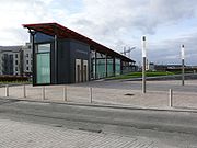
Clongriffin railway stationClongriffin railway station
Clongriffin railway station serves Dublin Area Rapid Transit and InterCity .-Location:Clongriffin railway station is situated along the Dublin–Belfast railway line between Portmarnock railway station and Howth Junction.-History:...
is situated along the Dublin–Belfast railway line between Howth Junction and Portmarnock railway station
Portmarnock railway station
Portmarnock railway station serves Portmarnock in County Dublin.The station opened on 25 May 1844.- External links :*...
, and is served by Dublin Area Rapid Transit
Dublin Area Rapid Transit
The Dublin Area Rapid Transit is part of the suburban railway network in Ireland, running mainly along the coastline of Dublin Bay on the Trans-Dublin route, from Greystones in County Wicklow, through Dublin to Howth and Malahide in County Dublin.Trains are powered via a 1500V DC overhead catenary...
(DART
Dublin Area Rapid Transit
The Dublin Area Rapid Transit is part of the suburban railway network in Ireland, running mainly along the coastline of Dublin Bay on the Trans-Dublin route, from Greystones in County Wicklow, through Dublin to Howth and Malahide in County Dublin.Trains are powered via a 1500V DC overhead catenary...
) and InterCity (Iarnród Éireann)
InterCity (Iarnród Éireann)
InterCity is the brand name given to rail services operated by Iarnród Éireann that run between Dublin and other major cities in the Republic of Ireland.-Services:InterCity services from Dublin operate from two main stations:...
.
A "Park-and-Ride" underground car park, with more than 500 spaces, is located on Clongriffin's Main Street.
Bus
Dublin BusDublin Bus
Dublin Bus is a public transport operator in Ireland. It operates an extensive bus network of 172 radial, cross-city and peripheral routes and 18 night routes in the city of Dublin and the Greater Dublin Area. The company, established in 1987, is a subsidiary of Córas Iompair Éireann which is...
provides the 128 service which is one of Dublin's 'cross town' routes. It serves from Station Square, Clongriffin to Palmerston Park, Rathmines
Rathmines
Rathmines is a suburb on the southside of Dublin, about 3 kilometres south of the city centre. It effectively begins at the south side of the Grand Canal and stretches along the Rathmines Road as far as Rathgar to the south, Ranelagh to the east and Harold's Cross to the west.Rathmines has...
via Malahide Road, Dublin Connolly railway station
Dublin Connolly railway station
Dublin Connolly, commonly called Connolly station , is one of the main railway stations in Dublin, Ireland, and is a focal point in the Irish route network. Opened in 1844 as Amiens Street Station, the ornate facade has a distinctive Italianate tower at its centre...
, Nassau Street, Dublin
Nassau Street, Dublin
Nassau Street is a street in central Dublin, running along the south side of Trinity College. It runs from Grafton Street in the west, to the junction of South Leinster Street and Kildare Street in the East....
, and St Stephen's Green.
Also, the 29n Nitelink service provides late night service from D'Olier Street
D'Olier Street
D'Olier Street is a street in the southern city-centre of Dublin, the capital of Ireland. It and Westmoreland Street are two broad streets whose northern ends meet at the southern end of O'Connell Bridge over the River Liffey...
to Baldoyle Road, stopping on Grange Road approximately 1 km from Main Street, Clongriffin.
Amenities & Facilities
Clongriffin is currently serviced by a small supermarket (which also contains a sub-post office), an off-license, a barber and a Chinese restaurant, most at the beginning of the designated main street. Existing shopping facilities nearby (between 1 and 3 km away) include small shopping plazas at BaldoyleBaldoyle
Baldoyle is a small coastal area on the northside of Dublin, Ireland. It is in the part of the historic County Dublin now administered as Fingal.-Location and Access:...
and Clare Hall, and the larger Donaghmede Shopping Centre
Donaghmede Shopping Centre
Donaghmede Shopping Centre is a shopping centre, that is located in Donaghmede, a suburb in Dublin's Northside.The shopping centre is built on the site of the original Donaghmede House. The shopping centre had a H Williams supermarket, but was sold to Dunnes Stores in 1987...
and Clarehall Shopping Centre on the Malahide Road.
Occasionally, there is a market held at Station Square.
Cycling, walking and running
Station Square is a meeting point of several pedestrian, running and cycle routes. From the square, there is passage to Father Collins Park and beyond the civic steps to Dublin coastal walkways and Baldoyle Bay (the estuary of two rivers, and a noted wetland), declared a Nature ReserveNature reserve
A nature reserve is a protected area of importance for wildlife, flora, fauna or features of geological or other special interest, which is reserved and managed for conservation and to provide special opportunities for study or research...
in 1988.
Father Collins Park
Now Ireland's first wind powered and 'self-sustainable' public park, the redeveloped Father Collins Park adjacent to Clongriffin was officially reopened in May 2009.The park has since won a number of awards such as The Sustainability Award 2010, Best Public Space 2010, and Best Public Park & Best Environmentally Friendly Initiative for 2010. Most recently, it was short listed by the European Union Prize for Contemporary Architecture
European Union Prize for Contemporary Architecture
The European Union Prize for Contemporary Architecture or Mies van der Rohe award is a prize given biennially by the European Union and the Fundació Mies van der Rohe, Barcelona, 'to acknowledge and reward quality architectural production in Europe'...
2011.
With five 50 kW
Kw
kw or KW may refer to:* Kuwait, ISO 3166-1 country code** .kw, the country code top level domain for Kuwait* Kilowatt* Self-ionization of water Kw* Cornish language's ISO 639 code* Kitchener–Waterloo, Ontario, Canada...
wind turbines, it provides power for the projection of water from its central lake, the public lighting, maintenance depots, and sport club changing rooms.
The approximately 54 acre
Acre
The acre is a unit of area in a number of different systems, including the imperial and U.S. customary systems. The most commonly used acres today are the international acre and, in the United States, the survey acre. The most common use of the acre is to measure tracts of land.The acre is related...
(or 26 hectares) park encompasses some natural woodland
Woodland
Ecologically, a woodland is a low-density forest forming open habitats with plenty of sunlight and limited shade. Woodlands may support an understory of shrubs and herbaceous plants including grasses. Woodland may form a transition to shrubland under drier conditions or during early stages of...
; for sports, a peripheral running/cycling track, six playing pitches and six fitness stations; for leisure, a prominade, a concert amphitheatre and picnic areas with outdoor chess/draughts boards; and for activity, two playgrounds and a skate-park.
Education
Clongriffin has a crèche, The Learning Circle. Two new primary schools lie to the west of Clongriffin in BelmayneBelmayne
Belmayne is a new development of housing, and proposed adjunct facilities, in Balgriffin, a northern suburb of Dublin, Ireland. It is situated just off the Malahide Road, opposite the new Hilton Hotel. It is close to the M1 and M50, motorways and Dublin Airport, via the N32...
, another constituent estate of the North Fringe. One, St. Francis of Assisi, is under the patronage of the Roman Catholic Church and the other is an Educate Together facility. There are other nearby primary schools and second level schools in Donaghmede
Donaghmede
Donaghmede is a residential suburb of Dublin, in the province of Leinster, Ireland.-Location:Donaghmede is situated approximately to the north east of the Dublin city centre, and is in the constituency of Dublin North East...
and Baldoyle
Baldoyle
Baldoyle is a small coastal area on the northside of Dublin, Ireland. It is in the part of the historic County Dublin now administered as Fingal.-Location and Access:...
.
Religion
The Holy Trinity Church serves the Roman Catholic parishioners of Donaghmede-Clongriffin-Balgriffin Parish, the inception of which was in 1974.St. Doulagh's Church
St. Doulagh's Church
St Doulagh's Church, the oldest stone-roofed church still in use in Ireland, is situated approximately 10 kilometres from Dublin city, just north of the hamlet of Balgriffin...
, Balgriffin
Balgriffin
Balgriffin is a former rural, now largely residential, part of County Dublin, Ireland.-Location:Balgriffin is situated approximately from Dublin city centre...
serves Church of Ireland
Church of Ireland
The Church of Ireland is an autonomous province of the Anglican Communion. The church operates in all parts of Ireland and is the second largest religious body on the island after the Roman Catholic Church...
parishioners. The church has been used for services since the Tudor conquest of Ireland.
Nature
Clongriffin is also adjacent to Baldoyle Bay, with the estuaries of the Sluice River and Mayne River, and wetlands, all of which are protected by the National Parks and Wildlife ServiceNational Parks and Wildlife Service (Ireland)
The National Parks and Wildlife Service manages the Irish State's nature conservation responsibilities. It is part of the Department of the Environment, Heritage and Local Government....
.
Declared a Statutory
Law of the Republic of Ireland
The law of the Republic of Ireland consists of constitutional, statute and common law. The highest law in the Republic is the Constitution of Ireland, from which all other law derives its authority...
Nature Reserve
Nature reserve
A nature reserve is a protected area of importance for wildlife, flora, fauna or features of geological or other special interest, which is reserved and managed for conservation and to provide special opportunities for study or research...
in 1988, the inner estuarine part of the estuary
Estuary
An estuary is a partly enclosed coastal body of water with one or more rivers or streams flowing into it, and with a free connection to the open sea....
and wetlands of Baldoyle Bay are protected as a Special Area of Conservation
Special Area of Conservation
A Special Area of Conservation is defined in the European Union's Habitats Directive , also known as the Directive on the Conservation of Natural Habitats and of Wild Fauna and Flora...
(SAC). Under the Ramsar Convention
Ramsar Convention
The Ramsar Convention is an international treaty for the conservation and sustainable utilization of wetlands, i.e., to stem the progressive encroachment on and loss of wetlands now and in the future, recognizing the fundamental ecological functions of wetlands and their economic, cultural,...
, the wetlands have been designated as of international importance. They support several habitats that are listed on the EU Habitats Directive.
The open lands of Clongriffin and Father Collins Park continue to host migrating birds
Bird migration
Bird migration is the regular seasonal journey undertaken by many species of birds. Bird movements include those made in response to changes in food availability, habitat or weather. Sometimes, journeys are not termed "true migration" because they are irregular or in only one direction...
, including Arctic and African-Eurasian migratory birds. Of particular interest is the internationally important population of Brent Geese who frequent the broad area around Baldoyle Bay.
There was until the late 1990's a stream running west and north west from the south eastern corner of Father Collins Park (where Main Street now passes), to Stapolin and into the Grange Stream tributary of the Mayne River. This stream is no longer visible.
Early history
The lands of Baldoyle, on which Clongriffin is situated, formed part of a large tract of highHigh Middle Ages
The High Middle Ages was the period of European history around the 11th, 12th, and 13th centuries . The High Middle Ages were preceded by the Early Middle Ages and followed by the Late Middle Ages, which by convention end around 1500....
medieval
Middle Ages
The Middle Ages is a periodization of European history from the 5th century to the 15th century. The Middle Ages follows the fall of the Western Roman Empire in 476 and precedes the Early Modern Era. It is the middle period of a three-period division of Western history: Classic, Medieval and Modern...
monastic
Christian monasticism
Christian monasticism is a practice which began to develop early in the history of the Christian Church, modeled upon scriptural examples and ideals, including those in the Old Testament, but not mandated as an institution in the scriptures. It has come to be regulated by religious rules Christian...
grange farmland, sometimes called the "Grange of Baldoyle." A reminder of this is the small church now called "Grange Abbey
Grange Abbey
Grange Abbey is a ruined chapel on the former Grange of Baldoyle lands, now in Donaghmede, in the townland of Baldoyle, at the northern edge of Dublin city, Ireland.-History:...
" to the south of Clongriffin. In 1166, the lands were assigned to All Saints Priory, on whose site Trinity College Dublin was later built, by Diarmait Mac Murchada, King of Leinster.
In 1369, parliament
Parliament of Ireland
The Parliament of Ireland was a legislature that existed in Dublin from 1297 until 1800. In its early mediaeval period during the Lordship of Ireland it consisted of either two or three chambers: the House of Commons, elected by a very restricted suffrage, the House of Lords in which the lords...
was held in the small church, called by Sir William de Windsor.
In the late 1530s, at the beginning of the Tudor conquest of Ireland, the entire settlement was invaded and seized at the behest of King Henry VIII of England
Henry VIII of England
Henry VIII was King of England from 21 April 1509 until his death. He was Lord, and later King, of Ireland, as well as continuing the nominal claim by the English monarchs to the Kingdom of France...
, who in 1538 bestowed it on the Corporation of Dublin
Dublin Corporation
Dublin Corporation , known by generations of Dubliners simply as The Corpo, is the former name given to the city government and its administrative organisation in Dublin between 1661 and 1 January 2002...
.
Modern history
Until 2003, most of the lands on which Clongriffin is being built remained as farmland.In July of the same year Dublin City Council
Dublin City Council
Dublin City Council is the local authority for the city of Dublin in Ireland. It has 52 members and is the largest local authority in Ireland. Until 2001, it was known as Dublin Corporation.-Legal status:...
granted planning permission for a mixed-use development to be called, 'Clongriffin at Grange Road, Donaghmede' now forming part of the 'Northern Fringe Development' (from Clongriffin to Belmayne
Belmayne
Belmayne is a new development of housing, and proposed adjunct facilities, in Balgriffin, a northern suburb of Dublin, Ireland. It is situated just off the Malahide Road, opposite the new Hilton Hotel. It is close to the M1 and M50, motorways and Dublin Airport, via the N32...
).
With management plans completed in 2004, the development, comprising houses and apartments, started in 2005, and was planned to have educational, retail and service facilities, including a multi-screen cinema. Forming part of the Northern Fringe Development (along with Belmayne
Belmayne
Belmayne is a new development of housing, and proposed adjunct facilities, in Balgriffin, a northern suburb of Dublin, Ireland. It is situated just off the Malahide Road, opposite the new Hilton Hotel. It is close to the M1 and M50, motorways and Dublin Airport, via the N32...
in Balgriffin
Balgriffin
Balgriffin is a former rural, now largely residential, part of County Dublin, Ireland.-Location:Balgriffin is situated approximately from Dublin city centre...
and estates on the former Baldoyle Racecourse and in north Coolock), approved by the local authorities to provide new accommodation for Dublin on what was "green belt" land, and was to complete the development of north Donaghmede. Clongriffin's developments comprise of Grange Lodge, Beau Park, Station Point and Marrsfield.
For further history and general notes, see also the Donaghmede
Donaghmede
Donaghmede is a residential suburb of Dublin, in the province of Leinster, Ireland.-Location:Donaghmede is situated approximately to the north east of the Dublin city centre, and is in the constituency of Dublin North East...
and Baldoyle
Baldoyle
Baldoyle is a small coastal area on the northside of Dublin, Ireland. It is in the part of the historic County Dublin now administered as Fingal.-Location and Access:...
articles.
Provision of services
No area of the estate has yet been taken in charge by Dublin City CouncilDublin City Council
Dublin City Council is the local authority for the city of Dublin in Ireland. It has 52 members and is the largest local authority in Ireland. Until 2001, it was known as Dublin Corporation.-Legal status:...
and the Council maintains that it has made no commitment in this respect. Nevertheless, refuse collection responsibility is taken by the Dublin City Council in tandem with the private management company. However, it has been relayed to the local community that Irish Rail requested that Dublin City Council take Main Street in charge before the opening of the railway station.
Pyrite settlement and remediation
In early 2008 it was alleged that the mineral pyrite was found in the stone hardcore used in the construction of some residential units in various estates in north Dublin, including Beaupark in Clongriffin. Currently, pyritePyrite
The mineral pyrite, or iron pyrite, is an iron sulfide with the formula FeS2. This mineral's metallic luster and pale-to-normal, brass-yellow hue have earned it the nickname fool's gold because of its resemblance to gold...
remedition of affected ground level dwellings is underway, after, in March 2011, a settlement was reached in the pyrite Commercial Court case. Menolly Homes and The Lagan Group accepted responsiblity for the defective infill used, and have set up of a Trust Fund to cover costs for remediation of all homes affected by pyrite in Clongriffin. In May 2011, remediation began.
Road maintenance and other developments
Roads in the main Clongriffin development are thought to be maintained by Gannon Homes, however, responsibility for the upkeep of the roads remains under dispute.Development has been stalled as a result of the downturn in the Irish economy
Economy of the Republic of Ireland
The economy of Ireland has transformed in recent years from an agricultural focus to a modern knowledge economy, focusing on services and high-tech industries and dependent on trade, industry and investment. In terms of GDP per capita, Ireland is ranked as one of the wealthiest countries in the...
, developer financial problems, and reduced demand. Some areas remain enclosed by construction hoarding. Dublin City Council are formulating a Local Area Plan for the North Fringe as part of the Dublin City Development Plan 2011-2017. This plan will guide future development in the area.