
City of Hawthorn
Encyclopedia

Melbourne
Melbourne is the capital and most populous city in the state of Victoria, and the second most populous city in Australia. The Melbourne City Centre is the hub of the greater metropolitan area and the Census statistical division—of which "Melbourne" is the common name. As of June 2009, the greater...
, the state capital of Victoria
Victoria (Australia)
Victoria is the second most populous state in Australia. Geographically the smallest mainland state, Victoria is bordered by New South Wales, South Australia, and Tasmania on Boundary Islet to the north, west and south respectively....
, Australia
Australia
Australia , officially the Commonwealth of Australia, is a country in the Southern Hemisphere comprising the mainland of the Australian continent, the island of Tasmania, and numerous smaller islands in the Indian and Pacific Oceans. It is the world's sixth-largest country by total area...
, on the southeast bank of the Yarra River
Yarra River
The Yarra River, originally Birrarung, is a river in east-central Victoria, Australia. The lower stretches of the river is where the city of Melbourne was established in 1835 and today Greater Melbourne dominates and influences the landscape of its lower reaches...
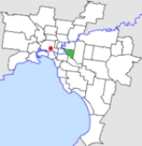
. The city covered an area of 9.71 square kilometres (3.75 sq mi), and existed from 1860 until 1994.
History
Hawthorn was first incorporated as a municipal district on 27 July 1860, becoming a town on 18 March 1887. It was proclaimed a City on 12 September 1890.On 22 June 1994, the City of Hawthorn was abolished and merged into the newly-created City of Boroondara
City of Boroondara
The City of Boroondara is a Local Government Area in Victoria, Australia. It is located in the eastern suburbs of Melbourne.This area was originally occupied by the Wurundjeri, Indigenous Australians of the Kulin nation....
along with the Cities of Kew
City of Kew
The City of Kew was a Local Government Area located about east of Melbourne, the state capital of Victoria, Australia, on the southeast bank of the Yarra River. The city covered an area of , and existed from 1860 until 1994.-History:...
and Camberwell
City of Camberwell
The City of Camberwell was a Local Government Area located about east of Melbourne, the state capital of Victoria, Australia. The city covered an area of , and existed from 1914 until 1994.-History:...
.
The council met at the Hawthorn Town Hall
Hawthorn Town Hall
Hawthorn Town Hall is a civic building located in Hawthorn, a suburb of Melbourne, Australia. Designed by architect John Beswicke in the Second Empire style, the hall was built from 1888–1890 and housed the council chambers for the City of Hawthorn...
at the corner of Burwood and Glenferrie Roads near Glenferrie railway station, Hawthorn. The facility is still used by the City of Boroondara
City of Boroondara
The City of Boroondara is a Local Government Area in Victoria, Australia. It is located in the eastern suburbs of Melbourne.This area was originally occupied by the Wurundjeri, Indigenous Australians of the Kulin nation....
.
Wards
Hawthorn was divided into four wards on 1 October 1923, each electing three councillors:- Auburn Ward
- Glenferrie Ward
- Power Ward
- Yarra Ward
Geography
The council area covered the suburbs of HawthornHawthorn, Victoria
Hawthorn is a suburb in Melbourne, Victoria, Australia, east from Melbourne's central business district. Its Local Government Area is the City of Boroondara...
, Hawthorn East
Hawthorn East, Victoria
Hawthorn East is a suburb in Melbourne, Victoria, Australia, 9 km east from Melbourne's central business district. Its Local Government Area is the City of Boroondara...
and part of Glen Iris
Glen Iris, Victoria
Glen Iris is a suburb in Melbourne, Victoria, Australia, 10 km south-east from Melbourne's central business district. Its Local Government Area are the Cities of Boroondara and Stonnington...
, and was bounded by the Yarra River
Yarra River
The Yarra River, originally Birrarung, is a river in east-central Victoria, Australia. The lower stretches of the river is where the city of Melbourne was established in 1835 and today Greater Melbourne dominates and influences the landscape of its lower reaches...
to the west, Barkers Road to the north, Gardiners Creek and the CityLink
CityLink
CityLink is a system of tolled urban Highways in Melbourne, Victoria, Australia. The company Transurban was awarded the contract to augment two existing freeways and construct two new Toll roads—labelled the Western and Southern Links—directly linking a number of existing freeways to...
(formerly South Eastern Freeway) to the south and Burke Road
Burke Road, Melbourne
Burke Road is a major north-south thoroughfare in Melbourne, Australia. It runs from Ivanhoe to Caulfield, and includes the major shopping district at Camberwell...
to the east.
Population
| Year | Population |
|---|---|
| 1861 | 2,342 |
| 1881 | 6,019 |
| 1891 | 19,585 |
| 1947 | 40,464 |
| 1954 | 37,188 |
| 1958 | 35,700* |
| 1961 | 36,707 |
| 1966 | 36,717 |
| 1971 | 37,571 |
| 1976 | 32,505 |
| 1981 | 30,689 |
| 1986 | 29,623 |
| 1991 | 30,006 |
* Estimate in the 1958 Victorian Year Book.