
City of Boroondara
Encyclopedia
Victoria (Australia)
Victoria is the second most populous state in Australia. Geographically the smallest mainland state, Victoria is bordered by New South Wales, South Australia, and Tasmania on Boundary Islet to the north, west and south respectively....
, Australia
Australia
Australia , officially the Commonwealth of Australia, is a country in the Southern Hemisphere comprising the mainland of the Australian continent, the island of Tasmania, and numerous smaller islands in the Indian and Pacific Oceans. It is the world's sixth-largest country by total area...
. It is located in the eastern suburb
Suburb
The word suburb mostly refers to a residential area, either existing as part of a city or as a separate residential community within commuting distance of a city . Some suburbs have a degree of administrative autonomy, and most have lower population density than inner city neighborhoods...
s of Melbourne
Melbourne
Melbourne is the capital and most populous city in the state of Victoria, and the second most populous city in Australia. The Melbourne City Centre is the hub of the greater metropolitan area and the Census statistical division—of which "Melbourne" is the common name. As of June 2009, the greater...
.
This area was originally occupied by the Wurundjeri
Wurundjeri
The Wurundjeri are a people of the Indigenous Australian nation of the Woiwurrung language group, in the Kulin alliance, who occupy the Birrarung Valley, its tributaries and the present location of Melbourne, Australia...
, Indigenous Australians
Indigenous Australians
Indigenous Australians are the original inhabitants of the Australian continent and nearby islands. The Aboriginal Indigenous Australians migrated from the Indian continent around 75,000 to 100,000 years ago....
of the Kulin
Kulin
The Kulin nation, was an alliance of five Indigenous Australian nations in Central Victoria, Australia, prior to European settlement. Their collective territory extended to around Port Phillip and Western Port, up into the Great Dividing Range and the Loddon and Goulburn River valleys. To their...
nation.
In 1837, John Gardiner
John Gardiner (colonist)
John Gardiner was a nineteenth century Australian banker and pastoralist.-References:*A. S. Kenyon, 'The Overlanders', Victorian Historical Magazine, 10...
(after whom Gardiners Creek
Gardiners Creek
Gardiners Creek, originally known as Kooyongkoot Creek, is a waterway in the eastern suburbs of Melbourne, and part of the Yarra River catchment....
was named) and his family were the first Europeans to settle here.
Robert Hoddle
Robert Hoddle
Robert Hoddle was a surveyor of Port Phillip in the 1830s, and the creator of the Hoddle Grid, the street grid system upon which inner city Melbourne is based. He was also an accomplished artist and depicted scenes of the Port Philip region as well as New South Wales...
surveyed the area in 1837 and declared it the "Parish of Boroondara". The area was densely wooded, so he took a word from the Woiwurrung
Woiwurrung
Woiwurrung is an Indigenous Australian language spoken by some of the Kulin Nation clans, the Wurundjeri people, of Central Victoria, from Mount Baw Baw in the east to Mount Macedon, Sunbury and Gisborne in the west.The Woiwurrung clans inhabited the Yarra River, called Birrarung in Woiwurrung,...
language (as spoken by the Wurundjeri
Wurundjeri
The Wurundjeri are a people of the Indigenous Australian nation of the Woiwurrung language group, in the Kulin alliance, who occupy the Birrarung Valley, its tributaries and the present location of Melbourne, Australia...
), meaning "where the ground is thickly shaded".
The first Local Government body was the Boroondara District Road Board, formed on 11 July 1854 and incorporating the areas which were to become the City of Hawthorn
City of Hawthorn
The City of Hawthorn was a Local Government Area located about east of Melbourne, the state capital of Victoria, Australia, on the southeast bank of the Yarra River. The city covered an area of , and existed from 1860 until 1994.-History:...
, City of Kew
City of Kew
The City of Kew was a Local Government Area located about east of Melbourne, the state capital of Victoria, Australia, on the southeast bank of the Yarra River. The city covered an area of , and existed from 1860 until 1994.-History:...
and City of Camberwell
City of Camberwell
The City of Camberwell was a Local Government Area located about east of Melbourne, the state capital of Victoria, Australia. The city covered an area of , and existed from 1914 until 1994.-History:...
. Hawthorn and Kew were created as separate municipalities in 1860 and the remaining area of the Road Board became Shire of Boroondara on 17 November 1871, which later became the City of Camberwell. The three were amalgamated on 15 December 1994 to create the City of Boroondara.
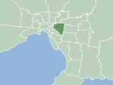
It has an area of 60 km², and in 2009, it had an estimated population of 168,090. Boroondara was rated ninth of 590 Australian Local Government Areas in the BankWest Quality of Life Index 2008.
Local Government
Boroondara City Council is the third tier of government and deals with services such as garbage collectionWaste management
Waste management is the collection, transport, processing or disposal,managing and monitoring of waste materials. The term usually relates to materials produced by human activity, and the process is generally undertaken to reduce their effect on health, the environment or aesthetics...
, building and planning permits and approvals, roads, drainage, health services, youth services, children's services food safety, parks and gardens, library services, pets, street parking permits and the collection of rates
Rates (tax)
Rates are a type of property tax system in the United Kingdom, and in places with systems deriving from the British one, the proceeds of which are used to fund local government...
and charges.
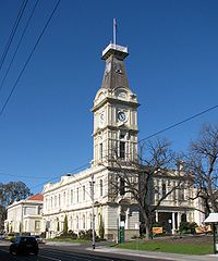
Boroondara council's main office in Camberwell underwent a $20 million redevelopment. The historical facade facing Camberwell Road remains largely unchanged whereas the main entrance facing Inglesby Road has been refurbished. The project was completed in February, 2010.
Wards and councillors
| Ward | contains parts of… | Past and present councillors |
|---|---|---|
| Bellevue | Balwyn North, Kew East | Eric Risstrom (1996–2003), Gina Goldsmith (2003–2004), Luke Tobin (2004–2008), Brad Miles (2008–present) |
| Cotham | Kew, Balwyn, Balwyn North | Geoff Hayes (1996–2004), Lachlan Williams (2004–2007), Phil Meggs (2007–2008), David Bloom (2008–present) |
| Gardiner | Glen Iris, Hawthorn East, Hawthorn, Camberwell | Will Charlton (1996–2002), Coral Ross (2002–present) |
| Glenferrie | Hawthorn, Kew | Nigel Kirby (1996–1999), Meredith Butler (1999–2008), Phil Meggs (2008–present) |
| Junction | Camberwell, Hawthorn East, Canterbury | Lilian Weinberg (1996–1999), Martina Hayes (1999–2002), Jack Wegman (2002–present) |
| Lynden | Camberwell, Glen Iris, Canterbury | Ian Wallace (1996–2002), Heinz Kreutz (2002–present) |
| Maling | Canterbury, Surrey Hills, Balwyn | Loreto Davey (1996–2002), Dennis Whelan (2002–2004), Dick Menting (2004–present) |
| Maranoa | Balwyn, Balwyn North, | Chris Pattas (1996–2004), Nicholas Tragas (2004–present) |
| Solway | Ashburton, Glen Iris | Keith Walter (1996–2004), Mary Halikias-Byrnes (2004–2008), Kevin Chow (2008–present) |
| Studley | Kew, Hawthorn | Paula Davey (1996–1999), Judith Voce (1999–2004), Phillip Healey (2004–present) |
Infrastructure
The Council is responsible for the management of stormwater collection and removal. The water supply authority is Yarra Valley WaterYarra Valley Water
Yarra Valley Water is a retail water company owned by the State Government of Victoria .They provide water and sewer services to about 1.5 million people in the Melbourne, Australia area....
.
Libraries
The City of Boroondara has five libraries at CamberwellCamberwell, Victoria
Camberwell is a suburb in Melbourne, Victoria, Australia, 9 km east from Melbourne's central business district. Its Local Government Area is the City of Boroondara. At the 2006 Census, Camberwell had a population of 19,637....
, Ashburton
Ashburton, Victoria
Ashburton is a suburb in Melbourne, Victoria, Australia, 12 km south-east from Melbourne's central business district. Its Local Government Area is the City of Boroondara...
, Balwyn
Balwyn, Victoria
Balwyn is a suburb in Melbourne, Victoria, Australia, 10 km east from Melbourne's central business district. Its Local Government Area is the City of Boroondara...
, Kew
Kew, Victoria
Kew is a suburb in Melbourne, Victoria, Australia, 6 km east from Melbourne's central business district. Its Local Government Area is the City of Boroondara. At the 2006 Census, Kew had a population of 22,516....
and Hawthorn
Hawthorn, Victoria
Hawthorn is a suburb in Melbourne, Victoria, Australia, east from Melbourne's central business district. Its Local Government Area is the City of Boroondara...
.
Schools
Boroondara contains many private schools, including Xavier College, Methodist Ladies' CollegeMethodist Ladies' College, Melbourne
Methodist Ladies' College is an independent, non-selective, day and boarding school for girls, located in Kew, an eastern suburb of Melbourne, Victoria, Australia...
(MLC), Camberwell Grammar School
Camberwell Grammar School
Camberwell Grammar School is an independent, Anglican, day school for boys, located in Canterbury, an eastern suburb of Melbourne, Victoria, Australia....
, Trinity Grammar School
Trinity Grammar School, Victoria
Trinity Grammar School is an independent Anglican day and boarding school for boys, located across several campuses in Melbourne, Victoria, Australia....
, Ruyton Girls' School
Ruyton Girls' School
Ruyton Girls' School , is a non-denominational, independent, day school for girls, located in the inner-eastern Melbourne suburb of Kew, Victoria, Australia....
, Carey Baptist Grammar School
Carey Baptist Grammar School
Carey Baptist Grammar School is an independent, co-educational, Christian, international, day school consisting of four campuses in Victoria, Australia - Kew , Donvale , the Carey Sports Complex in Bulleen and an outdoor education camp near Paynesville in eastern Gippsland called Carey...
, Scotch College
Scotch College, Melbourne
Scotch College, Melbourne is an independent, Presbyterian, day and boarding school for boys, located in Hawthorn, an inner-eastern suburb of Melbourne, Victoria, Australia....
, Fintona Girls' School
Fintona Girls' School
Fintona Girls' School is a small, independent, non-denominational, day school for girls, located in Balwyn, an eastern suburb of Melbourne, Victoria, Australia....
, Genazzano FCJ College
Genazzano FCJ College
Genazzano FCJ College is a Roman Catholic, day and boarding school for girls, located in Kew, an eastern suburb of Melbourne, Victoria, Australia....
and Preshil
Preshil
Preshil, or The Margaret Lyttle Memorial School, is an independent, co-educational, non-denominational, Progressive, school located in Kew, an eastern suburb of Melbourne, Victoria, Australia.Founded in the early 1930s by Margaret J. R. Lyttle...
. It contains Catholic schools such as St Michael's Parish School
St Michael's Parish School
St Michael's Parish School is a Catholic co-ed primary school located in Ashburton, Victoria Australia. It comprises approximately 240 students from prep to year 6 and has 25 staff members....
(Ashburton) and St Bede's School (Balwyn North) and a number of public schools, including Canterbury Girls Secondary College, Balwyn High School
Balwyn High School
Balwyn High School is a state-run high school in the suburb of Balwyn North, in Melbourne, Victoria, Australia. It was established in 1954. As of 2009 it has some 2,000 students and over 180 staff, making it one of the largest schools in the inner-eastern suburbs of Melbourne or the third largest...
, Kew High School
Kew High School
Kew High School is a co-educational school in suburban Melbourne, Victoria, Australia, for students in years 7–12. It has over 1,400 students from the neighbourhoods of Kew, Balwyn, Ivanhoe, East Ivanhoe, Alphington, Rosanna, Clifton Hill, Richmond, Abbotsford, Hawthorn and Bundoora, with waiting...
Solway Primary School and Camberwell High School
Camberwell High School
Camberwell High School is a government-funded, co-educational high for years 7 to 12 located on Prospect Hill Road in Canterbury, a suburb of Melbourne, Victoria, Australia....
.
Some of the suburbs mentioned above are shared with other City Councils,
- Glen IrisGlen Iris, VictoriaGlen Iris is a suburb in Melbourne, Victoria, Australia, 10 km south-east from Melbourne's central business district. Its Local Government Area are the Cities of Boroondara and Stonnington...
(shared with City of StonningtonCity of StonningtonThe City of Stonnington is a Local Government Area located within the metropolitan area of Melbourne, Victoria, Australia. It comprises the inner south-eastern suburbs, between 3 and 13 kilometres from the Melbourne CBD...
) - Mont AlbertMont Albert, VictoriaMont Albert is a suburb in Melbourne, Victoria, Australia, 12 km east from Melbourne's central business district. Its Local Government Area are the Cities of Whitehorse and Boroondara. At the 2006 Census, Mont Albert had a population of 4419....
(shared with City of WhitehorseCity of WhitehorseThe City of Whitehorse is a Local Government Area in Victoria, Australia. It is located in the eastern suburbs of Melbourne. It has an area of and has a estimated population of 155,725 people....
) - Surrey HillsSurrey Hills, VictoriaSurrey Hills is a suburb in Melbourne, Victoria, Australia, 12 km east from Melbourne's central business district. Its Local Government Area lies within the cities of Boroondara and Whitehorse...
(shared with City of WhitehorseCity of WhitehorseThe City of Whitehorse is a Local Government Area in Victoria, Australia. It is located in the eastern suburbs of Melbourne. It has an area of and has a estimated population of 155,725 people....
)
Major thoroughfares
- Auburn Road
- Balwyn Road
- Barkers Road

- Belmore Road
- Burke RoadBurke Road, MelbourneBurke Road is a major north-south thoroughfare in Melbourne, Australia. It runs from Ivanhoe to Caulfield, and includes the major shopping district at Camberwell...

- Burwood Road

- Camberwell Road
- Canterbury Road
- Chandler Highway

- Church Street


- Cotham Road

- Denmark Street
- Doncaster Road
- Eastern Freeway

- Glenferrie Road

- High Street, Ashburton

- High Street, Kew
- Mont Albert Road
- Power Street
- Princess Street
- Riversdale Road

- Studley Park Road
- Toorak Road

- Tooronga Road
- Union Road
- Warrigal Road

- Whitehorse Road