
City of Camberwell
Encyclopedia
Melbourne
Melbourne is the capital and most populous city in the state of Victoria, and the second most populous city in Australia. The Melbourne City Centre is the hub of the greater metropolitan area and the Census statistical division—of which "Melbourne" is the common name. As of June 2009, the greater...
, the state capital of Victoria
Victoria (Australia)
Victoria is the second most populous state in Australia. Geographically the smallest mainland state, Victoria is bordered by New South Wales, South Australia, and Tasmania on Boundary Islet to the north, west and south respectively....
, Australia
Australia
Australia , officially the Commonwealth of Australia, is a country in the Southern Hemisphere comprising the mainland of the Australian continent, the island of Tasmania, and numerous smaller islands in the Indian and Pacific Oceans. It is the world's sixth-largest country by total area...
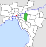
. The city covered an area of 36.01 square kilometres (13.9 sq mi), and existed from 1914 until 1994.
History
Camberwell was first incorporated as the Boroondara Roads District on 11 July 1864, which became the Shire of Boroondara on 17 November 1871. At this point, Camberwell consisted of two small settlements—one near the Camberwell Inn and the other to the east at Hartwell. Much of the shire's area was under cultivation with a few sites for fine residences at the northern end.The Shire was renamed to Shire of Camberwell and Boroondara on 16 May 1905. It became a borough
Borough
A borough is an administrative division in various countries. In principle, the term borough designates a self-governing township although, in practice, official use of the term varies widely....
on 28 April 1905, the Town of Camberwell on 15 May 1906 and a City by proclamation on 20 April 1914.
The council's pathway to amalgamation was a little different to most—following a redevelopment deal for land behind the Burke Road
Burke Road, Melbourne
Burke Road is a major north-south thoroughfare in Melbourne, Australia. It runs from Ivanhoe to Caulfield, and includes the major shopping district at Camberwell...
shops which was rejected by most residents, the Council reneged on the deal and had damages awarded against it. On 22 June 1993 the Council was suspended and replaced with a commissioner. At the same time, a major reform of local government in Victoria was taking place, and the decision was made to merge Camberwell with the Cities of Hawthorn
City of Hawthorn
The City of Hawthorn was a Local Government Area located about east of Melbourne, the state capital of Victoria, Australia, on the southeast bank of the Yarra River. The city covered an area of , and existed from 1860 until 1994.-History:...
and Kew
City of Kew
The City of Kew was a Local Government Area located about east of Melbourne, the state capital of Victoria, Australia, on the southeast bank of the Yarra River. The city covered an area of , and existed from 1860 until 1994.-History:...
into the newly-created City of Boroondara
City of Boroondara
The City of Boroondara is a Local Government Area in Victoria, Australia. It is located in the eastern suburbs of Melbourne.This area was originally occupied by the Wurundjeri, Indigenous Australians of the Kulin nation....
, which took effect on 22 June 1994.
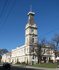
Council meetings were held at Camberwell Town Hall
Camberwell Town Hall
Camberwell Town Hall is located, on Camberwell Road, Camberwell, an inner eastern suburb of Melbourne, Australia.The Town Hall was built in 1891 in the free classical style and features Second Empire influences in the steep pitch of the clock tower's pyramidal mansard roof.After the amalgamatian of...
in Camberwell Road, Camberwell. It presently serves as the council seat for the City of Boroondara
City of Boroondara
The City of Boroondara is a Local Government Area in Victoria, Australia. It is located in the eastern suburbs of Melbourne.This area was originally occupied by the Wurundjeri, Indigenous Australians of the Kulin nation....
.
Wards
The City of Camberwell was subdivided into four wards on 22 May 1934, each electing three councillors:- North East Ward
- North West Ward
- Centre Ward
- South Ward
Suburbs
- AshburtonAshburton, VictoriaAshburton is a suburb in Melbourne, Victoria, Australia, 12 km south-east from Melbourne's central business district. Its Local Government Area is the City of Boroondara...
- BalwynBalwyn, VictoriaBalwyn is a suburb in Melbourne, Victoria, Australia, 10 km east from Melbourne's central business district. Its Local Government Area is the City of Boroondara...
- Balwyn NorthBalwyn North, VictoriaBalwyn North is a suburb in Melbourne, Victoria, Australia, 11 km east from Melbourne's central business district. Its Local Government Area is the City of Boroondara...
- BurwoodBurwood, VictoriaBurwood is a suburb in Melbourne, Victoria, Australia, 17 km east from Melbourne's central business district. Its Local Government Area is largely the City of Whitehorse but includes the City of Monash in its south west corner. At the 2006 Census, Burwood had a population of 11,886.-History:The...
(split with City of Box HillCity of Box HillThe City of Box Hill was a Local Government Area located about east of Melbourne, the state capital of Victoria, Australia. The city covered an area of , and existed from 1927 until 1994.-History:...
and City of WaverleyCity of WaverleyThe City of Waverley was a Local Government Area located about east-southeast of Melbourne, the state capital of Victoria, Australia. The city covered an area of , and existed from 1857 until 1994.-History:...
) - CamberwellCamberwell, VictoriaCamberwell is a suburb in Melbourne, Victoria, Australia, 9 km east from Melbourne's central business district. Its Local Government Area is the City of Boroondara. At the 2006 Census, Camberwell had a population of 19,637....
- CanterburyCanterbury, VictoriaCanterbury is a suburb in Melbourne, Victoria, Australia, 10 km east from Melbourne's central business district. Its Local Government Area is the City of Boroondara...
- Glen IrisGlen Iris, VictoriaGlen Iris is a suburb in Melbourne, Victoria, Australia, 10 km south-east from Melbourne's central business district. Its Local Government Area are the Cities of Boroondara and Stonnington...
(split with City of MalvernCity of MalvernThe City of Malvern was a Local Government Area located about southeast of Melbourne, the state capital of Victoria, Australia. The city covered an area of , and existed from 1856 until 1994.-History:...
and City of HawthornCity of HawthornThe City of Hawthorn was a Local Government Area located about east of Melbourne, the state capital of Victoria, Australia, on the southeast bank of the Yarra River. The city covered an area of , and existed from 1860 until 1994.-History:...
) - Surrey HillsSurrey Hills, VictoriaSurrey Hills is a suburb in Melbourne, Victoria, Australia, 12 km east from Melbourne's central business district. Its Local Government Area lies within the cities of Boroondara and Whitehorse...
(split with City of Box HillCity of Box HillThe City of Box Hill was a Local Government Area located about east of Melbourne, the state capital of Victoria, Australia. The city covered an area of , and existed from 1927 until 1994.-History:...
)
Population
| Year | Population |
|---|---|
| 1911 | 12,551 |
| 1933 | 50,052 |
| 1947 | 76,125 |
| 1954 | 90,397 |
| 1958 | 99,300* |
| 1961 | 99,353 |
| 1966 | 99,867 |
| 1971 | 98,302 |
| 1976 | 89,865 |
| 1981 | 85,883 |
| 1986 | 83,792 |
| 1991 | 83,799 |
* Estimate in the 1958 Victorian Year Book.