
Cheriton Hill
Encyclopedia
Cheriton Hill is a hill near Folkestone
in the south-east corner of the English
county of Kent
, overlooking the English Channel
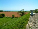
. The relatively low-lying hill (reaching only 188 metres above sea level) is covered with farmland, villages, narrow lanes, and footpaths. The highest point is on a covered reservoir next to the trig point
; the highest natural point is nearby, probably close to the road to the village of Paddlesworth, near a transmitter mast, but the relatively flat summit gives no real impression of being on top of a hill.
 By contrast, the southern edge of the hill is a steep escarpment
which carries the ancient track named Pilgrims' Way
, which is believed to date from 500–450 BC, and which runs from Folkestone
along the North Downs
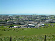
hills. At this point the escarpment overlooks the huge Cheriton Channel Tunnel
terminal, with views to France
across the roofs of Folkestone
. The slope of this escarpment forms part of the Folkestone Downs
and is the location of the Folkestone White Horse
, completed in 2003.
Cheriton Hill was the location of the discovery of the Late Spider orchid
in the 19th century. At one point the number of known plants at Folkestone/Cheriton declined to just six, but with improved management of the chalk
grassland
by Eurotunnel and the White Cliffs Countryside Project, the population is now much healthier, estimated in 2008 to be 165 plants, some 30% of the UK
population.
Cheriton Hill is one of the Marilyns
identified since the publication of The Relative Hills of Britain in 1992, and is the most easterly Marilyn.
Folkestone
Folkestone is the principal town in the Shepway District of Kent, England. Its original site was in a valley in the sea cliffs and it developed through fishing and its closeness to the Continent as a landing place and trading port. The coming of the railways, the building of a ferry port, and its...
in the south-east corner of the English
England
England is a country that is part of the United Kingdom. It shares land borders with Scotland to the north and Wales to the west; the Irish Sea is to the north west, the Celtic Sea to the south west, with the North Sea to the east and the English Channel to the south separating it from continental...
county of Kent
Kent
Kent is a county in southeast England, and is one of the home counties. It borders East Sussex, Surrey and Greater London and has a defined boundary with Essex in the middle of the Thames Estuary. The ceremonial county boundaries of Kent include the shire county of Kent and the unitary borough of...
, overlooking the English Channel
English Channel
The English Channel , often referred to simply as the Channel, is an arm of the Atlantic Ocean that separates southern England from northern France, and joins the North Sea to the Atlantic. It is about long and varies in width from at its widest to in the Strait of Dover...
. The relatively low-lying hill (reaching only 188 metres above sea level) is covered with farmland, villages, narrow lanes, and footpaths. The highest point is on a covered reservoir next to the trig point
Trig point
A triangulation station, also known as a triangulation pillar, trigonometrical station, trigonometrical point, trig station, trig beacon or trig point, and sometimes informally as a trig, is a fixed surveying station, used in geodetic surveying and other surveying projects in its vicinity...
; the highest natural point is nearby, probably close to the road to the village of Paddlesworth, near a transmitter mast, but the relatively flat summit gives no real impression of being on top of a hill.
Escarpment
An escarpment is a steep slope or long cliff that occurs from erosion or faulting and separates two relatively level areas of differing elevations.-Description and variants:...
which carries the ancient track named Pilgrims' Way
Pilgrims' Way
The Pilgrims' Way is the historic route supposed to have been taken by pilgrims from Winchester in Hampshire, England, to the shrine of Thomas Becket at Canterbury in Kent...
, which is believed to date from 500–450 BC, and which runs from Folkestone
Folkestone
Folkestone is the principal town in the Shepway District of Kent, England. Its original site was in a valley in the sea cliffs and it developed through fishing and its closeness to the Continent as a landing place and trading port. The coming of the railways, the building of a ferry port, and its...
along the North Downs
North Downs
The North Downs are a ridge of chalk hills in south east England that stretch from Farnham in Surrey to the White Cliffs of Dover in Kent. The North Downs lie within two Areas of Outstanding Natural Beauty , the Surrey Hills and the Kent Downs...
hills. At this point the escarpment overlooks the huge Cheriton Channel Tunnel
Channel Tunnel
The Channel Tunnel is a undersea rail tunnel linking Folkestone, Kent in the United Kingdom with Coquelles, Pas-de-Calais near Calais in northern France beneath the English Channel at the Strait of Dover. At its lowest point, it is deep...
terminal, with views to France
France
The French Republic , The French Republic , The French Republic , (commonly known as France , is a unitary semi-presidential republic in Western Europe with several overseas territories and islands located on other continents and in the Indian, Pacific, and Atlantic oceans. Metropolitan France...
across the roofs of Folkestone
Folkestone
Folkestone is the principal town in the Shepway District of Kent, England. Its original site was in a valley in the sea cliffs and it developed through fishing and its closeness to the Continent as a landing place and trading port. The coming of the railways, the building of a ferry port, and its...
. The slope of this escarpment forms part of the Folkestone Downs
Folkestone Downs
The Folkestone Downs are an area of chalk downland above Folkestone, where the eastern end of the North Downs escarpment meets the English Channel...
and is the location of the Folkestone White Horse
Folkestone White Horse
The Folkestone White Horse is a white horse hill figure, carved into Cheriton Hill, Folkestone, Kent, South East England. It overlooks the English terminal of the Channel Tunnel and was completed in June 2003....
, completed in 2003.
Cheriton Hill was the location of the discovery of the Late Spider orchid
Orchidaceae
The Orchidaceae, commonly referred to as the orchid family, is a morphologically diverse and widespread family of monocots in the order Asparagales. Along with the Asteraceae, it is one of the two largest families of flowering plants, with between 21,950 and 26,049 currently accepted species,...
in the 19th century. At one point the number of known plants at Folkestone/Cheriton declined to just six, but with improved management of the chalk
Southern England Chalk Formation
The Chalk Formation of Southern England is a system of chalk downland in the south of England. The formation is perhaps best known for Salisbury Plain, the location of Stonehenge, the Isle of Wight and the twin ridgeways of the North Downs and South Downs....
grassland
Grassland
Grasslands are areas where the vegetation is dominated by grasses and other herbaceous plants . However, sedge and rush families can also be found. Grasslands occur naturally on all continents except Antarctica...
by Eurotunnel and the White Cliffs Countryside Project, the population is now much healthier, estimated in 2008 to be 165 plants, some 30% of the UK
United Kingdom
The United Kingdom of Great Britain and Northern IrelandIn the United Kingdom and Dependencies, other languages have been officially recognised as legitimate autochthonous languages under the European Charter for Regional or Minority Languages...
population.
Cheriton Hill is one of the Marilyns
Marilyn (hill)
A Marilyn is a mountain or hill in the United Kingdom, Republic of Ireland or Isle of Man with a relative height of at least 150 metres , regardless of absolute height or other merit...
identified since the publication of The Relative Hills of Britain in 1992, and is the most easterly Marilyn.