
Cheaha Mountain
Encyclopedia
Cheaha Mountain often called Mount Cheaha, is the highest natural point in the U.S. state
of Alabama
. It is located a few miles north-west of the town of Delta in scenic Cheaha State Park
, which contains a lodge, restaurant
, and other amenities.
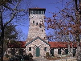
The highest point is marked with a USGS marker (photo below) in front of Bunker Tower
, a stone Civilian Conservation Corps
building with an observation deck on top. The CCC also constructed a road to Cheaha, but the road has been closed for years. The old road is locally referred to as the "CC Road
" and contains interesting, inaccessible ruins. Near the peak is Bald Rock, which was recently improved with a wheelchair-accessible wooden walkway that provides an impressive overlook
of the surrounding region. The entire area gives an impression of being at a much higher elevation than it actually is, in part because of the relatively low elevation of the adjacent area to the west.
Cheaha Mountain is part of the Talladega Mountains, a final southern segment of the Blue Ridge
, unlike other elevations of the Appalachians
in north Alabama, which are part of the Cumberland Plateau
. The mountain also has the unique distinction of being the highest geographical point in the eastern portion of the Sun Belt
(south of Interstate 20
, and north of the Gulf of Mexico
).
The mountain is a host to several commercial and public service transmitters. These transmitters, along with sundry structures dating back to commercial schemes by the State of Alabama in the Seventies, stand in stark contrast to the surrounding natural environment. The Calhoun County Amateur Radio Association has a repeater near the peak and Alabama Public Television
has its transmitter
for WCIQ TV (and digital DTV
52), a tower 176 meters tall. This mountain is also known to hold the location of the Summer Camp known as Camp Mac
The mountain was opened to the public as a state park on June 7, 1939.
U.S. state
A U.S. state is any one of the 50 federated states of the United States of America that share sovereignty with the federal government. Because of this shared sovereignty, an American is a citizen both of the federal entity and of his or her state of domicile. Four states use the official title of...
of Alabama
Alabama
Alabama is a state located in the southeastern region of the United States. It is bordered by Tennessee to the north, Georgia to the east, Florida and the Gulf of Mexico to the south, and Mississippi to the west. Alabama ranks 30th in total land area and ranks second in the size of its inland...
. It is located a few miles north-west of the town of Delta in scenic Cheaha State Park
Cheaha State Park
Cheaha State Park is a state park in Alabama, located in northern Clay and southwestern Cleburne counties. Park facilities include a lodge, restaurant, general store, campsites, hiking trails , and other amenities...
, which contains a lodge, restaurant
Restaurant
A restaurant is an establishment which prepares and serves food and drink to customers in return for money. Meals are generally served and eaten on premises, but many restaurants also offer take-out and food delivery services...
, and other amenities.
The highest point is marked with a USGS marker (photo below) in front of Bunker Tower
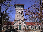
Bunker Tower
Bunker Tower is an observation tower on the peak of Cheaha Mountain in Cheaha State Park located in Cleburne County, Alabama, U.S.A. The tower is located at the peak of Cheaha Mountain, the highest point in Alabama. The tower is a large stone building completed in the 1930s by the Civilian...
, a stone Civilian Conservation Corps
Civilian Conservation Corps
The Civilian Conservation Corps was a public work relief program that operated from 1933 to 1942 in the United States for unemployed, unmarried men from relief families, ages 18–25. A part of the New Deal of President Franklin D...
building with an observation deck on top. The CCC also constructed a road to Cheaha, but the road has been closed for years. The old road is locally referred to as the "CC Road
CC Road
During the Great Depression the Civilian Conservation Corps constructed a road to the ridge of Cheaha Mountain, the highest point in Alabama. The local name for the road is now official, the "CC Road" with one of the Cs of the Civilian Conservation Corps having been lost over the years in local...
" and contains interesting, inaccessible ruins. Near the peak is Bald Rock, which was recently improved with a wheelchair-accessible wooden walkway that provides an impressive overlook
Overlook
A scenic overlook, or just an overlook, observation point, lookout or viewing point, is a high place where people can gather to view scenery , and to photograph it. Scenic overlooks are typically created alongside mountain roads, often as a simple turnouts where motorists can pull over onto...
of the surrounding region. The entire area gives an impression of being at a much higher elevation than it actually is, in part because of the relatively low elevation of the adjacent area to the west.
Cheaha Mountain is part of the Talladega Mountains, a final southern segment of the Blue Ridge
Blue Ridge Mountains
The Blue Ridge Mountains are a physiographic province of the larger Appalachian Mountains range. This province consists of northern and southern physiographic regions, which divide near the Roanoke River gap. The mountain range is located in the eastern United States, starting at its southern-most...
, unlike other elevations of the Appalachians
Appalachian Mountains
The Appalachian Mountains #Whether the stressed vowel is or ,#Whether the "ch" is pronounced as a fricative or an affricate , and#Whether the final vowel is the monophthong or the diphthong .), often called the Appalachians, are a system of mountains in eastern North America. The Appalachians...
in north Alabama, which are part of the Cumberland Plateau
Cumberland Plateau
The Cumberland Plateau is the southern part of the Appalachian Plateau. It includes much of eastern Kentucky and western West Virginia, part of Tennessee, and a small portion of northern Alabama and northwest Georgia . The terms "Allegheny Plateau" and the "Cumberland Plateau" both refer to the...
. The mountain also has the unique distinction of being the highest geographical point in the eastern portion of the Sun Belt
Sun Belt
The Sun Belt or Spanish Belt is a region of the United States generally considered to stretch across the South and Southwest . Another rough boundary of the region is the area south of the 36th parallel, north latitude. It is the largest region which the U.S government does not recognize officially...
(south of Interstate 20
Interstate 20
Interstate 20 is a major east–west Interstate Highway in the Southern United States. I‑20 runs 1,535 miles from near Kent, Texas, at Interstate 10 to Florence, South Carolina, at Interstate 95...
, and north of the Gulf of Mexico
Gulf of Mexico
The Gulf of Mexico is a partially landlocked ocean basin largely surrounded by the North American continent and the island of Cuba. It is bounded on the northeast, north and northwest by the Gulf Coast of the United States, on the southwest and south by Mexico, and on the southeast by Cuba. In...
).
The mountain is a host to several commercial and public service transmitters. These transmitters, along with sundry structures dating back to commercial schemes by the State of Alabama in the Seventies, stand in stark contrast to the surrounding natural environment. The Calhoun County Amateur Radio Association has a repeater near the peak and Alabama Public Television
Alabama Public Television
Alabama Public Television is a state network of Public Broadcasting Service member non-commercial educational Public television stations serving the US state of Alabama. The television stations are licensed by the Alabama Educational Television Commission, which was created by the Alabama state...
has its transmitter
Transmitter
In electronics and telecommunications a transmitter or radio transmitter is an electronic device which, with the aid of an antenna, produces radio waves. The transmitter itself generates a radio frequency alternating current, which is applied to the antenna. When excited by this alternating...
for WCIQ TV (and digital DTV
Digital television
Digital television is the transmission of audio and video by digital signals, in contrast to the analog signals used by analog TV...
52), a tower 176 meters tall. This mountain is also known to hold the location of the Summer Camp known as Camp Mac
Camp Mac
Camp Mac is a summer camp for boys and girls in Alabama's Cheaha Mountains, surrounded by the Talladega National Forest. Camp Mac offers a Jr. Term, which is 2 weeks long and is a starter camp for children who have completed the 2nd through 5th grade. They also offer two premium 4 Week Terms that...
The mountain was opened to the public as a state park on June 7, 1939.