

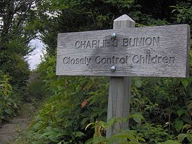
Charlies Bunion
Encyclopedia
Great Smoky Mountains
The Great Smoky Mountains are a mountain range rising along the Tennessee–North Carolina border in the southeastern United States. They are a subrange of the Appalachian Mountains, and form part of the Blue Ridge Physiographic Province. The range is sometimes called the Smoky Mountains or the...
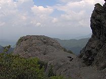
of the Southeastern United States, characterized by a large boulder-like protrusion just below the summit on its otherwise-sheer northern face. The mountain is a rare instance of a bare-rock summit in the Smokies.
Charlies Bunion rises to an elevation of 5,565 feet (1,696 m) above sea level, and is situated along the state line between Sevier County, Tennessee
Sevier County, Tennessee
Sevier County is a county of the state of Tennessee, United States. Its population was 71,170 at the 2000 United States Census. It is included in the Sevierville, Tennessee, Micropolitan Statistical Area, which is included in the Knoxville-Sevierville-La Follette, TN Combined Statistical Area. The...
and Swain County, North Carolina
Swain County, North Carolina
Swain County is a county located in the U.S. state of North Carolina. As of 2000, the population was 12,968. Its county seat is Bryson City.Swain County is home of the Nantahala River . The Nantahala is one of the most popular whitewater rafting rivers in the nation...
. The Appalachian Trail
Appalachian Trail
The Appalachian National Scenic Trail, generally known as the Appalachian Trail or simply the AT, is a marked hiking trail in the eastern United States extending between Springer Mountain in Georgia and Mount Katahdin in Maine. It is approximately long...
crosses the mountain's northern slope some four miles (6 km) east of Newfound Gap
Newfound Gap
Newfound Gap is a mountain pass located near the center of the Great Smoky Mountains National Park of the southern Appalachian Mountains in the United States of America. Situated along the border of Tennessee and North Carolina, the state line crosses the gap, as does U.S...
, allowing easy access to dayhikers and rock climbers.
Geology
Precambrian
The Precambrian is the name which describes the large span of time in Earth's history before the current Phanerozoic Eon, and is a Supereon divided into several eons of the geologic time scale...
metamorphic rock of the Ocoee Supergroup known as "Anakeesta Formation," which consists mainly of slate. The Anakeesta Formation, which comprises much of the crest of the Central Smokies, was created nearly a billion years ago from ancient ocean sediments. The rock was thrust upward during the Appalachian orogeny, when the North American and African plates collided around 400 million years ago.
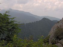
The steep northern face of Charlies Bunion is drained by the headwaters of the Middle Fork of the Little Pigeon River, and loses 2,000 feet (609 m) in elevation in just over a mile. The southern face, which is more gradual, is drained by the headwaters of the Oconaluftee River, specifically Kephart Prong and Bradley Fork.
History
Horace Kephart
Horace Kephart was an American travel writer and librarian, best known as the author of Our Southern Highlanders, about his life in the Great Smoky Mountains of western North Carolina.-Biography:...
as "so rough that you could not make seven miles a day in it to save your life..."
While the main route across the crest of the Smokies was the old Indian Gap Trail (now U.S. Route 441
U.S. Route 441
U.S. Route 441 is a spur route of U.S. Route 41. It currently runs for 939 miles from U.S. Route 41 in Miami, Florida to U.S. Route 25W in Lake City, Tennessee. Between its termini, US 441 passes through the states of Florida, Georgia, North Carolina, and Tennessee...
), which crested between Newfound Gap and Clingmans Dome
Clingmans Dome
Clingmans Dome is a mountain in the Great Smoky Mountains of Tennessee and North Carolina, in the southeastern United States. At an elevation of , it is the highest mountain in the Smokies, the highest point in the state of Tennessee, and the highest point along the Appalachian Trail...
, an alternative route was to ascend Kephart Prong to Dry Sluice Gap, on the eastern flank of Charlies Bunion, and descend into the Porters Creek Valley. The Whaley brothers, William and Middleton, used this route around 1800 while traveling from Oconaluftee
Oconaluftee (Great Smoky Mountains)
Oconaluftee is the name of a river valley in the Great Smoky Mountains of North Carolina, located in the Southeastern United States. Formerly the site of a Cherokee village and Appalachian community, the valley's bottomland is now home to the main entrance to the North Carolina section of the...
to what is now Greenbrier
Greenbrier (Great Smoky Mountains)
Greenbrier is a valley in the northern Great Smoky Mountains of Tennessee, located in the Southeastern United States. Now a recreational area, Greenbrier was once home to a string of Appalachian communities....
.
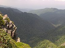
Charlies Bunion, like most of the central crest of the Smokies, was fairly heavily-forested until the 20th century. Large-scale logging operations in the Oconaluftee valley, however, left large piles of dry, dead brushwood scattered about the streambeds above Smokemont. In 1925, a massive forest fire, feeding off this dry foliage, raced up Kephart Prong, and quickly spread across the Sawteeth and over into Tennessee. The heat from the fire was so intense, it not only scorched every plant in its path, but it rendered the soil sterile. Then in 1929, a cloudburst
Cloudburst
A cloudburst is an extreme amount of precipitation, sometimes with hail and thunder, which normally lasts no longer than a few minutes but is capable of creating flood conditions.-Etymology:There are similar names for such events in other languages...
dumped torrential rains on the Smokies, washing away the scalded soil from the western flank of the Sawteeth and giving it its current rocky appearance.
Horace Kephart
Horace Kephart was an American travel writer and librarian, best known as the author of Our Southern Highlanders, about his life in the Great Smoky Mountains of western North Carolina.-Biography:...
climbed to the crest of the Central Smokies to inspect the damage. When they reached the now-barren western flank of the Sawteeth, Charlie Conner, a mountain guide from Oconaluftee, removed his shoe, revealing a badly-swollen foot. Upon seeing this, Kephart was said to have remarked, "I'm going to get this put on a Government map for you." There is another, slightly
different, story told by Paul M. Fink in his book
"The Names and Lore of The Great Smoky Mountains"
in which Fink says that one of the group upon looking at the bare rock pinnacle left by the
storm, and knowing of Conner's foot affliction,
remarked: "Well that sticks out like Charlie's
bunion" prompting Kephart to decide on that name. The United States Geological Survey
United States Geological Survey
The United States Geological Survey is a scientific agency of the United States government. The scientists of the USGS study the landscape of the United States, its natural resources, and the natural hazards that threaten it. The organization has four major science disciplines, concerning biology,...
gave it the name "Charlie's Bunion" shortly thereafter. The mountain rising above Charlies Bunion
Mount Kephart
Mount Kephart is a mountain in the central Great Smoky Mountains, located in the Southeastern United States. The Appalachian Trail crosses the mountain's south slope, making it a key destination for thru-hikers. The Jumpoff, a cliff on the northeast side of the mountain, allows for spectacular...
to the west was named after Kephart himself.
In 1935, the Civilian Conservation Corps
Civilian Conservation Corps
The Civilian Conservation Corps was a public work relief program that operated from 1933 to 1942 in the United States for unemployed, unmarried men from relief families, ages 18–25. A part of the New Deal of President Franklin D...
constructed a leg of the Appalachian Trail across the northern face of Charlies Bunion for the Great Smoky Mountains National Park
Great Smoky Mountains National Park
Great Smoky Mountains National Park is a United States National Park and UNESCO World Heritage Site that straddles the ridgeline of the Great Smoky Mountains, part of the Blue Ridge Mountains, which are a division of the larger Appalachian Mountain chain. The border between Tennessee and North...
, which had officially opened the previous year. Today, the mountain's summit and characteristic boulder-like protrusion offer great views of Tennessee
Tennessee
Tennessee is a U.S. state located in the Southeastern United States. It has a population of 6,346,105, making it the nation's 17th-largest state by population, and covers , making it the 36th-largest by total land area...
and the other peaks of the main ridge in the Smokies, especially Mount Le Conte and Mount Kephart.