

Greenbrier (Great Smoky Mountains)
Encyclopedia
Great Smoky Mountains
The Great Smoky Mountains are a mountain range rising along the Tennessee–North Carolina border in the southeastern United States. They are a subrange of the Appalachian Mountains, and form part of the Blue Ridge Physiographic Province. The range is sometimes called the Smoky Mountains or the...
of Tennessee
Tennessee
Tennessee is a U.S. state located in the Southeastern United States. It has a population of 6,346,105, making it the nation's 17th-largest state by population, and covers , making it the 36th-largest by total land area...
, located in the Southeastern United States. Now a recreational area, Greenbrier was once home to a string of Appalachia
Appalachia
Appalachia is a term used to describe a cultural region in the eastern United States that stretches from the Southern Tier of New York state to northern Alabama, Mississippi, and Georgia. While the Appalachian Mountains stretch from Belle Isle in Canada to Cheaha Mountain in the U.S...
n communities.
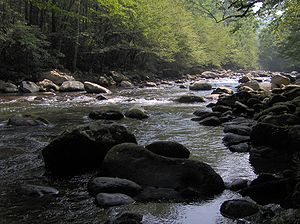
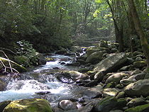
Greenbrier is situated along the Middle Fork of the Little Pigeon River
Little Pigeon River (Tennessee)
The Little Pigeon River is a river located entirely within Sevier County, Tennessee.It rises from a series of streams which flow together on the dividing ridge between the states of Tennessee and North Carolina inside the boundary of the Great Smoky Mountains National Park. The river is subdivided...
, stretching from Porters Flat in the south to Emert's Cove in the north, at the present park boundary. The area also includes the Middle Fork's immediate watershed from the crest of Grapeyard Ridge to the west (opposite the Roaring Fork
Roaring Fork (Great Smoky Mountains)
Roaring Fork is a stream in the Great Smoky Mountains of Tennessee, located in the Southeastern United States. Once the site of a small Appalachian community, today the stream's area is home to the Roaring Fork Motor Nature Trail and the Roaring Fork Historic District.Like many mountain streams,...
area) to Snag Mountain in the east. The area is sometimes called Big Greenbrier to distinguish it from Little Greenbrier
Little Greenbrier (Great Smoky Mountains)
Little Greenbrier is the name of a former Appalachian community that is now an historical area in the Great Smoky Mountains of East Tennessee. The community was situated in a hollow rising from Metcalf Bottoms along Little River to the upper slopes of Cove Mountain, in the northeastern section of...
, which is located between Wears Valley
Wears Valley, Tennessee
Wears Valley is an unincorporated area in Sevier County, Tennessee, treated by the U.S. Census Bureau as a census county division. As of the 2000 Census, the population of Wears Valley was 6,486....
and Elkmont
Elkmont, Tennessee
Elkmont is a region situated in the upper Little River Valley of the Great Smoky Mountains of Sevier County, in the U.S. state of Tennessee. Throughout its history, the valley has been home to a pioneer Appalachian community, a logging town, and a resort community...
several miles to the west.
Geology
Appalachian Mountains
The Appalachian Mountains #Whether the stressed vowel is or ,#Whether the "ch" is pronounced as a fricative or an affricate , and#Whether the final vowel is the monophthong or the diphthong .), often called the Appalachians, are a system of mountains in eastern North America. The Appalachians...
. To the east is the Guyot
Mount Guyot (Great Smoky Mountains)
Mount Guyot is a mountain in the eastern Great Smoky Mountains, located inthe southeastern United States. At above sea level, Guyot is the fourth-highestsummit in the eastern U.S., and the second-highest in the Great Smoky Mountains National Park...
massif
Massif
In geology, a massif is a section of a planet's crust that is demarcated by faults or flexures. In the movement of the crust, a massif tends to retain its internal structure while being displaced as a whole...
, which rises to over 6,000 feet (1,829 m) for long stretches. To the west is the Le Conte massif, which culminates in a 6,593-foot (2,009 m) summit. The ridge immediately to the south connecting the two massifs, known as "the Sawteeth," consists of a series of jagged, steep cliffs, the most well-known of which spans the northern face of Charlies Bunion
Charlies Bunion
Charlies Bunion is a mountain in the Great Smoky Mountains of the Southeastern United States, characterized by a large boulder-like protrusion just below the summit on its otherwise-sheer northern face...
. Greenbrier Pinnacle, a 7 miles (11.3 km) ridge descending from the western flank of Old Black
Old Black (Great Smoky Mountains)
Old Black is a mountain in the Great Smoky Mountains, located in the Southeastern United States. While often overshadowed by Mount Guyot, its higher neighbor to the south, Old Black is the 4th-highest mountain in...
westward to the Middle Fork valley, nearly closes off Greenbrier Cove entirely. Over a dozen streams flow north from the crest of the Pinnacle, each of them cutting narrow hollows with traces of fertile bottomland.
Metamorphic rock
Metamorphic rock is the transformation of an existing rock type, the protolith, in a process called metamorphism, which means "change in form". The protolith is subjected to heat and pressure causing profound physical and/or chemical change...
formation of the Ocoee Supergroup known as Roaring Fork Sandstone. This rock type, created from ancient ocean sediments 750 million years ago, dominates the mid-level elevations in the north-central Smokies. As the elevation increases to the south, a thrust fault known as the Greenbrier Fault separates the Roaring Fork sandstone from Thunderhead sandstone and Anakeesta Formation, both of which are common along the Smokies crest. To the north, as the land flattens out (near the park boundary), another thrust fault, the Gatlinburg Fault, separates the Roaring Fork formation from a layer of siltstone, which underlies the foothills around Emert's Cove.
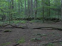
Like the Sugarlands and Roaring Fork to the west, Greenbrier's bottomlands and streambeds are coated with sandstone, phyllite, and slate rocks of all sizes. During the Ice Age
Ice age
An ice age or, more precisely, glacial age, is a generic geological period of long-term reduction in the temperature of the Earth's surface and atmosphere, resulting in the presence or expansion of continental ice sheets, polar ice sheets and alpine glaciers...
s, the cold weather caused fracturing of the high mountain slopes, creating boulder fields. Over the centuries, erosional forces carried these boulders to lower elevations. Greenbrier's residents used these rocks for fencing in lieu of barbed wire, creating the long rock walls that criss-cross the area today.
Early history
Smilax
Smilax is a genus of about 300-350 species, found in temperate zones, tropics and subtropics worldwide. In China for example about 80 are found , while there are 20 in North America north of Mexico...
genus that are common throughout Southern Appalachia. Although it's unknown when the upper Middle Fork valley obtained this name, it was being called "Greenbrier" as early as the 1830s. The name is not uncommon elsewhere in the region.
The Cherokee
Cherokee
The Cherokee are a Native American people historically settled in the Southeastern United States . Linguistically, they are part of the Iroquoian language family...
were the first inhabitants of the Greenbrier area, and may have had a seasonal settlement at Porters Flat, near Greenbrier's southern tip. As late as the early 20th century, residents of Greenbrier often referred to Porters Flat as "Indian Nation," which may hearken back to its days as a Cherokee settlement.
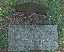
Around 1800, William Whaley (1788–1880) and his brother Middleton Whaley (1794–1855) became the first permanent Euro-American settlers in Greenbrier. The Whaleys hailed from North Carolina
North Carolina
North Carolina is a state located in the southeastern United States. The state borders South Carolina and Georgia to the south, Tennessee to the west and Virginia to the north. North Carolina contains 100 counties. Its capital is Raleigh, and its largest city is Charlotte...
, and crossed the crest of the Smokies at Dry Sluice Gap (near Charlies Bunion), which is just above Porters Flat. William Whaley settled at the confluence of Porters Creek and the Middle Fork of the Little Pigeon River. Middleton settled further down the valley, near Emert's Cove.
In 1818, the family of John Ownby (1781–1859), a veteran of the War of 1812
War of 1812
The War of 1812 was a military conflict fought between the forces of the United States of America and those of the British Empire. The Americans declared war in 1812 for several reasons, including trade restrictions because of Britain's ongoing war with France, impressment of American merchant...
, settled downstream from the Whaleys. The Whaley and Ownby families spread quickly throughout the valley. In the early 20th century, a map of Greenbrier showed the location of 26 homes— 11 were Whaleys and 10 were Ownbys.
Later settlers
Charles Rayfield (1825–1891) settled near the junction of Laurel Creek and the Middle Fork sometime before the Civil War. The Grapeyard Ridge Trail now winds through the former homesteads of many of Rayfield's children and grandchildren. David Proffitt (1847–1909), also a veteran of the war, settled further upstream, just below the Whaley lands, sometime around 1870. Around the same time, James Redwine, a circuit rider
Circuit rider (Religious)
Circuit rider is a popular term referring to clergy in the earliest years of the United States who were assigned to travel around specific geographic territories to minister to settlers and organize congregations...
, settled along the creek that now bears his name.
Benjamin Christenberry Parton (1832–1916), the son of a migrant farm worker, and his wife Margaret arrived in Greenbrier sometime in the 1850s. Parton, who survived a gunshot wound to the head during the Civil War, settled in the narrow flats just above the confluence of Little Bird Branch and the Middle Fork, at the western base of Greenbrier Pinnacle. Parton and many of his descendants are buried in a cemetery on a hill where his cabin once stood, overlooking Little Bird Branch.
Life in Greenbrier
We were slowly penetrating the great range within a few miles of the North Carolina border, passing cornfields so steep that we wondered how they could be cultivated, bouncing past old-time log cabins built of hand-hewn timber, and waving to unbelievably large numbers of silent children who watched amid the barking of their dogs
as strangers went by. We stopped by a cabin and inquired of an aged woman who sat leaning back in a homemade hickory chair with her feet on the rail, how far it was to Greenbriar, which had been designated to us
as the end of the trail that could be traversed by four wheels.
Like the Sugarlands to the west, Greenbrier was a largely isolated community until the early 20th century. The valley's economy was based on subsistence farming
Subsistence agriculture
Subsistence agriculture is self-sufficiency farming in which the farmers focus on growing enough food to feed their families. The typical subsistence farm has a range of crops and animals needed by the family to eat and clothe themselves during the year. Planting decisions are made with an eye...
, with most farms ranging in size from 50 to 100 acre (0.404686 km²), part of which was woodland. Most families lived in one-room log cabins surrounded by grassless yards and a paling fence, although modern-looking frame houses began to replace log structures when saw mills arrived in the area around 1900. Most farms included a barn, corn crib, smokehouse
Smokehouse
A smokehouse is a building where meat or fish is cured with smoke. The finished product might be stored in the building, sometimes for a year or more.-History:...
, springhouse, and a small orchard. Some of the wealthier families owned their own grist mill
Gristmill
The terms gristmill or grist mill can refer either to a building in which grain is ground into flour, or to the grinding mechanism itself.- Early history :...
. As game was plentiful, many farmers supplemented their income by hunting and trapping.
The residents of Greenbrier were largely pro-Union
Union (American Civil War)
During the American Civil War, the Union was a name used to refer to the federal government of the United States, which was supported by the twenty free states and five border slave states. It was opposed by 11 southern slave states that had declared a secession to join together to form the...
during the Civil War, although most tried to avoid the conflict altogether. A small force led by Confederate
Confederate States of America
The Confederate States of America was a government set up from 1861 to 1865 by 11 Southern slave states of the United States of America that had declared their secession from the U.S...
commander William Holland Thomas
William Holland Thomas
William Holland Thomas was Principal Chief of the Eastern Band of Cherokee Indians and an officer in the Confederate States Army during the American Civil War....
passed through Greenbrier while fleeing to North Carolina after being chased out of Gatlinburg. On the way, they inflicted minor amounts of damage to the farms of known Union supporters.
Shortly after the war, Greenbrier resident Perry Shults claimed to have discovered gold and silver at the headwaters of Porters Creek. In 1867, Shults received a charter from the Sevier County Silver, Copper, Lead, and Zinc Company for his find, and Shults began a low-key mining operation in the area. It was later discovered that Shults was producing counterfeit silver coins, and Shults fled west when the Secret Service
United States Secret Service
The United States Secret Service is a United States federal law enforcement agency that is part of the United States Department of Homeland Security. The sworn members are divided among the Special Agents and the Uniformed Division. Until March 1, 2003, the Service was part of the United States...
opened an investigation. The location of Shults' mine (or if it existed at all) is unknown.
Most all small communities in the Greenbrier area had at least one general store. Greenbrier residents would typically trade chickens, eggs, and animal furs for clothing, salt, pepper, coal oil
Coal oil
Coal oil is a term once used for a specific shale oil used for illuminating purposes. Coal oil is obtained from the destructive distillation of cannel coal, mineral wax, and bituminous shale, while kerosene is obtained by the distillation of petroleum...
, and medicine. As roads improved in the late 19th century, Greenbrier farmers could haul excess crops to Knoxville
Knoxville, Tennessee
Founded in 1786, Knoxville is the third-largest city in the U.S. state of Tennessee, U.S.A., behind Memphis and Nashville, and is the county seat of Knox County. It is the largest city in East Tennessee, and the second-largest city in the Appalachia region...
. These crops were typically corn or potatoes. Others dug ginseng
Ginseng
Ginseng is any one of eleven species of slow-growing perennial plants with fleshy roots, belonging to the genus Panax of the family Araliaceae....
, which was plentiful in the Smokies at the time, while others used their excess corn to make moonshine
Moonshine
Moonshine is an illegally produced distilled beverage...
. Bill Cardwell, who lived in the northern part of Greenbrier in the early 20th century, was said to have regularly sold moonshine to the Sheriff of Sevier County.
1900s
In the late 19th century, innovations in the logging industry, specifically the band saw
Band saw
A bandsaw is a power tool which uses a blade consisting of a continuous band of metal with teeth along one edge to cut various workpieces. The band usually rides on two wheels rotating in the same plane, although some small bandsaws have three wheels. Bandsawing produces uniform cutting action as a...
, led to a rapid deforestation of the woodland along the Ohio Valley and Mississippi Delta
Mississippi Delta
The Mississippi Delta is the distinctive northwest section of the U.S. state of Mississippi that lies between the Mississippi and Yazoo Rivers. The region has been called "The Most Southern Place on Earth" because of its unique racial, cultural, and economic history...
. As demand for timber increased, lumber companies turned to the dense, mature forests of Appalachia
Appalachia
Appalachia is a term used to describe a cultural region in the eastern United States that stretches from the Southern Tier of New York state to northern Alabama, Mississippi, and Georgia. While the Appalachian Mountains stretch from Belle Isle in Canada to Cheaha Mountain in the U.S...
. Saw mills began to spring up around the Smokies, with major logging operations taking place above Elkmont
Elkmont, Tennessee
Elkmont is a region situated in the upper Little River Valley of the Great Smoky Mountains of Sevier County, in the U.S. state of Tennessee. Throughout its history, the valley has been home to a pioneer Appalachian community, a logging town, and a resort community...
and the Oconaluftee watershed. Greenbrier residents David Proffitt and Pinkney Whaley erected a saw mill near Porters Flat, and by 1916 had helped log some 738 acres (3 km²) of the Porters Creek watershed.
Around this time, the writings of authors such as Horace Kephart
Horace Kephart
Horace Kephart was an American travel writer and librarian, best known as the author of Our Southern Highlanders, about his life in the Great Smoky Mountains of western North Carolina.-Biography:...
began to draw tourists to the Smokies. Greenbrier residents had always offered lodging to the various loggers, surveyors, and fur trappers who visited the valley, but no major hotel existed that could rival the likes of Andy Huff's Mountain View Hotel in Gatlinburg. In 1925, Kimsey and James West Whaley bought the old Greenbrier schoolhouse (which had burned), and remodeled it as a lodge. Hotel LeConte, as it was known, was opened that same year. Located near the junction of Porters Creek and the Middle Fork, the hotel operated until 1935, with rates of $1.75/day. Robert Parke recalled Hotel LeConte as:
...the largest building we had seen in the mountains. Some enterprising mountaineer, foreseeing the time the mountain country would bow to the relentless inroads of civilization, had constructed out of rough-sawed boards a two-story building with several rooms in which we found he had accommodated an occasional surveyor and such hardy individuals as would penetrate the mountains.
The hotel made a convenient jumping point for excursions to nearby Mount Le Conte and Mount Guyot. Its foundation remains today, just off Ramsey Prong Road.
The national park
Tourism and heavy logging led to increased demands from conservationists to protect the Great Smoky Mountains. A national forestUnited States National Forest
National Forest is a classification of federal lands in the United States.National Forests are largely forest and woodland areas owned by the federal government and managed by the United States Forest Service, part of the United States Department of Agriculture. Land management of these areas...
was established by the Weeks Act of 1911, and in 1926, the Great Smoky Mountains Park Commission began buying up land for a national park. While the residents of Greenbrier were displaced, many simply moved to the other side of the park boundary to Emert's Cove and the Webb Mountain area. Two former Greenbrier residents, Conley Huskey and Glenn Cardwell, would eventually serve as the mayor of Pittman Center
Pittman Center, Tennessee
Pittman Center is a town in Sevier County, Tennessee, United States. The population was 477 at the 2000 census.Pittman Center is situated in Emert's Cove, a broad valley along the Middle Fork of the Little Pigeon River...
, just two miles (3 km) north of Greenbrier.
Many members of the Parton family relocated to Locust Ridge, a hilly area between Pittman Center and Richardson Cove. The family's most famous member, Dolly Parton
Dolly Parton
Dolly Rebecca Parton is an American singer-songwriter, author, multi-instrumentalist, actress and philanthropist, best known for her work in country music. Dolly Parton has appeared in movies like 9 to 5, The Best Little Whorehouse in Texas, Steel Magnolias and Straight Talk...
(1946—), is the great-great-granddaughter of Benjamin Christenberry Parton. Descendants of other Greenbrier residents now operate a number of varying businesses along U.S. Route 321
U.S. Route 321
U.S. Route 321 is a spur of U.S. Route 21. It runs for 526 miles from South Carolina to Tennessee. The northern terminus of U.S. 321 is between Lenoir City and Oak Ridge, Tennessee, at Interstate 40 exit 364, which is about 4 miles west of Interstate 40's junction with Interstate 75...
between Gatlinburg and Cosby
Cosby, Tennessee
Cosby is an unincorporated community in Cocke County, Tennessee, United States. Although it is not a census-designated place, the ZIP Code Tabulation Area for the ZIP Code that serves Cosby had a population of 5,201 as of the 2000 U.S. Census...
. One Whaley family would eventually be displaced three times by eminent domain
Eminent domain
Eminent domain , compulsory purchase , resumption/compulsory acquisition , or expropriation is an action of the state to seize a citizen's private property, expropriate property, or seize a citizen's rights in property with due monetary compensation, but without the owner's consent...
— once when the NPS purchased their farm in Greenbrier, then again when the Tennessee Valley Authority
Tennessee Valley Authority
The Tennessee Valley Authority is a federally owned corporation in the United States created by congressional charter in May 1933 to provide navigation, flood control, electricity generation, fertilizer manufacturing, and economic development in the Tennessee Valley, a region particularly affected...
purchased their land for the construction of Norris Dam
Norris Dam
Norris Dam is a hydroelectric and flood control structure located on the Clinch River in Anderson County and Campbell County, Tennessee, USA. Its construction in the mid-1930s was the first major project for the Tennessee Valley Authority, which had been created in 1933 to bring economic...
, and a third time when their land was purchased in Oak Ridge
Oak Ridge, Tennessee
Oak Ridge is a city in Anderson and Roane counties in the eastern part of the U.S. state of Tennessee, about west of Knoxville. Oak Ridge's population was 27,387 at the 2000 census...
for the Manhattan Project
Manhattan Project
The Manhattan Project was a research and development program, led by the United States with participation from the United Kingdom and Canada, that produced the first atomic bomb during World War II. From 1942 to 1946, the project was under the direction of Major General Leslie Groves of the US Army...
.
Many former residents of Greenbrier went on to become pastors, reflecting Greenbrier residents' deeply-held religious beliefs. Members of Greenbrier's Primitive Baptist community continued to meet as late as the 1980s.
In 1933, the Civilian Conservation Corps
Civilian Conservation Corps
The Civilian Conservation Corps was a public work relief program that operated from 1933 to 1942 in the United States for unemployed, unmarried men from relief families, ages 18–25. A part of the New Deal of President Franklin D...
established Camp David Chapman at near the confluence of Rhododendron Creek and the Middle Fork. This camp, which constructed most of the roads and trails in the Greenbrier area, provided valuable employment to locals during the Great Depression
Great Depression
The Great Depression was a severe worldwide economic depression in the decade preceding World War II. The timing of the Great Depression varied across nations, but in most countries it started in about 1929 and lasted until the late 1930s or early 1940s...
.
Greenbrier today
Greenbrier is now home to a ranger station and a general recreation area within the national park. A partially-paved road connects U.S. Route 321 to the Porters Creek and Ramsey Prong areas.Trails
The Grapeyard Ridge Trail follows Rhododendron Creek over the south slope of Brushy Mountain to the Jim Bales Place at Roaring Fork
Roaring Fork (Great Smoky Mountains)
Roaring Fork is a stream in the Great Smoky Mountains of Tennessee, located in the Southeastern United States. Once the site of a small Appalachian community, today the stream's area is home to the Roaring Fork Motor Nature Trail and the Roaring Fork Historic District.Like many mountain streams,...
. The trail passes the remains of the CCC Camp David Chapman, several Rayfield homesites, and the 1920s-era remains of a wrecked Nichols and Shepard self-propelled, steam-powered engine (known as a traction engine). The wrecked engine rests in the bed of Injun Creek.
The Ramsey Cascades Trail follows Ramsey Prong four miles (6 km) up the slope of Mount Guyot to Ramsey Cascades, a 65 feet (19.8 m) waterfall nestled between Guyot Spur and Greenbrier Pinnacle. For decades, hikers have used Ramsey Prong to bushwhack to the Appalachian Trail
Appalachian Trail
The Appalachian National Scenic Trail, generally known as the Appalachian Trail or simply the AT, is a marked hiking trail in the eastern United States extending between Springer Mountain in Georgia and Mount Katahdin in Maine. It is approximately long...
, just below Guyot's summit. A side-trail at the end of Ramsey Prong Road leads to the summit of Greenbrier Pinnacle.
The Porters Creek Trail follows Porters Creek to Porters Flat, where it passes the Messer Barn site before ascending to a backcountry campsite.
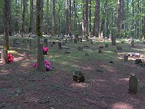
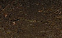
The Old Settlers Trail, one of the longest trails in the park, connects Greenbrier to the Cosby area. The trail was envisioned as a lower-elevation alternative to the Appalachian Trail, and was built by connecting the old roads in the various communities that existed between Greenbrier and Maddron Bald. The trail passes dozens of rock walls and chimney falls, as well as the Tyson McCarter Place. Spur trails connect the OST with several cemeteries, including Parton Cemetery and Lindsey Cemetery. Timber rattlesnakes
Crotalus horridus
Crotalus horridus, the timber rattlesnake, is a species of venomous pitviper found in the eastern United States. This is the only rattlesnake species in most of the populous northeastern United States. No subspecies are currently recognized....
are not an uncommon sight on the trail, as large numbers have long been known to live on the slopes of Greenbrier Pinnacle.
Historical sites
The Greenbrier area contains one of the park's largest concentrations of chimney falls and rock walls, which mark the sites of former homesteads. While most structures were removed in the 1930s, a few are preserved by the park service as representative of pioneer life in Appalachia. The John Messer Barn in Greenbrier Cove and the Tyson McCarter PlaceTyson McCarter Place
The Tyson McCarter Place was a homestead located in the Great Smoky Mountains of Sevier County, in the U.S. state of Tennessee. Before the establishment of the Great Smoky Mountains National Park in the 1930s, the homestead belonged to mountain farmer Jacob Tyson McCarter , a descendant of some of...
along Webb Creek are listed on the National Register of Historic Places
National Register of Historic Places
The National Register of Historic Places is the United States government's official list of districts, sites, buildings, structures, and objects deemed worthy of preservation...
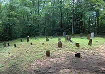
, and the Smoky Mountain Hiking Club Cabin has been deemed eligible for the National Register by the Tennessee Historical Commission. Plemmons Cemetery, located near the junction of Middle Fork and Porters Creek, is one of the largest cemeteries found within park boundaries.
John Messer Barn
Located along the Porters Creek Trail, the John Messer Barn was constructed in 1875 by Pinkney Whaley. The only remaining structure of the pre-park community of Greenbrier Cove, it was added to the National Register in 1976. The Messer Barn is a type of double-cantilever barn unique to East TennesseeEast Tennessee
East Tennessee is a name given to approximately the eastern third of the U.S. state of Tennessee, one of the three Grand Divisions of Tennessee defined in state law. East Tennessee consists of 33 counties, 30 located within the Eastern Time Zone and three counties in the Central Time Zone, namely...
and rarely found outside its immediate vicinity.
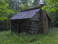
Smoky Mountain Hiking Club Cabin

Club member and prominent Knoxville architect Charles I. Barber
Charles I. Barber
Charles Irving Barber was an American architect, active primarily in Knoxville, Tennessee, and vicinity, during the first half of the 20th century...
, whose firm Barber & McMurry designed the park's headquarters and several notable buildings on the Arrowmont
Arrowmont School of Arts and Crafts
The Arrowmont School of Arts and Crafts is an arts and crafts center in the U.S. city of Gatlinburg, Tennessee. The oldest craft school in Tennessee, Arrowmont offers workshops in arts and crafts such as painting, woodworking, glassblowing, photography, basket weaving, and metalworking, and...
campus in Gatlinburg, designed the cabin and oversaw its construction using the labor of club members. The club used the logs from three dismantled Whaley cabins, and constructed the cabin around an existing chimney fall. The SMHC leased the cabin from the park service until 1981.
Tyson McCarter Place
The Tyson McCarter Place, located near where the Old Settlers Trail crosses Webb Creek just off U.S. Route 321, consists of a barn, corn crib, smokehouse, and springhouse constructed around 1876. Jacob Tyson McCarter purchased the farm around 1900, and in subsequent decades became a prominent member of the Webb Creek community. The area was placed on the National Register of Historic Places in 1976.Baxter Cabin
Maddron Bald Trail
The Maddron Bald Trail is an American hiking trail in the Great Smoky Mountains National Park of Cocke County, Tennessee. Rising from the outskirts of the Cosby community, the trail ascends Maddron Bald, a mountain crowned by one of the park's most substantial heath balds...
, was built by Willis Baxter and his son, William, in 1889. The cabin was originally a wedding gift to William, but was passed on to Willis' second son, Alex, when William's wife inherited property in Cosby. Chandler Jenkins was a later owner. The farm originally included two cabins, a barn, corn crib, smokehouse, hogpen, chicken house, and blacksmith shop, but this cabin and the chickenhouse are all that remain. In the 1950s, the chickenhouse was moved to the Mountain Farm Museum at Oconaluftee
Oconaluftee (Great Smoky Mountains)
Oconaluftee is the name of a river valley in the Great Smoky Mountains of North Carolina, located in the Southeastern United States. Formerly the site of a Cherokee village and Appalachian community, the valley's bottomland is now home to the main entrance to the North Carolina section of the...
.
The cabin is a single-pen cabin built of chestnut
American Chestnut
The American Chestnut is a large, deciduous tree of the beech family native to eastern North America. Before the species was devastated by the chestnut blight, a fungal disease, it was one of the most important forest trees throughout its range...
logs, and measures 16 feet (4.9 m) by 18 feet (5.5 m). The interior included a puncheon-log floor and a loft, and a "tater hole" (a kind of small root cellar
Root cellar
A root cellar is a structure built underground or partially underground and used to store vegetables, fruits, and nuts or other foods.-Construction:Common construction methods are:...
) near the fireplace. The front and back walls both have doors, although the cabin has no windows. An 8 feet (2.4 m) by 18 feet (5.5 m) lean-to kitchen was once attached to the west wall, but has been removed. The cabin's chimney is made of stone and mud.
External links
- Great Smoky Mountains National Park — official site
- Wrecked Steam Engines in the Smokies - contains photos and information on several Greenbrier-area trails, including the wrecked steam engine on Grapeyard Ridge