
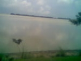
Chalan Beel
Encyclopedia
Wetland
A wetland is an area of land whose soil is saturated with water either permanently or seasonally. Wetlands are categorised by their characteristic vegetation, which is adapted to these unique soil conditions....
in Bangladesh
Bangladesh
Bangladesh , officially the People's Republic of Bangladesh is a sovereign state located in South Asia. It is bordered by India on all sides except for a small border with Burma to the far southeast and by the Bay of Bengal to the south...
. It is a large inland depression
Depression (geology)
A depression in geology is a landform sunken or depressed below the surrounding area. Depressions may be formed by various mechanisms.Structural or tectonic related:...
, marsh
Marsh
In geography, a marsh, or morass, is a type of wetland that is subject to frequent or continuous flood. Typically the water is shallow and features grasses, rushes, reeds, typhas, sedges, other herbaceous plants, and moss....
y in character, with rich flora
Flora
Flora is the plant life occurring in a particular region or time, generally the naturally occurring or indigenous—native plant life. The corresponding term for animals is fauna.-Etymology:...
and fauna
Fauna
Fauna or faunæ is all of the animal life of any particular region or time. The corresponding term for plants is flora.Zoologists and paleontologists use fauna to refer to a typical collection of animals found in a specific time or place, e.g. the "Sonoran Desert fauna" or the "Burgess shale fauna"...
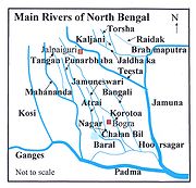
. Forty-seven rivers and other waterways flow into the Chalan Beel. As silt
Silt
Silt is granular material of a size somewhere between sand and clay whose mineral origin is quartz and feldspar. Silt may occur as a soil or as suspended sediment in a surface water body...
builds up in the beel
Beel
A beel or a bheel is a term for a pond with static water , in the Ganges - Brahmaputra flood plains of the Eastern Indian states of West Bengal, and Assam and in the country of Bangladesh...
, its size is being reduced.
Location and extent
Chalan Beel is an extensive lowlandLowland
In physical geography, a lowland is any broad expanse of land with a general low level. The term is thus applied to the landward portion of the upward slope from oceanic depths to continental highlands, to a region of depression in the interior of a mountainous region, to a plain of denudation, or...
area in the lower Atrai
Atrai River
Atrai River flows in West Bengal and northern parts of Bangladesh.In ancient times the river was called Atrei and finds a mention in the Mahabharata. It is linked with Karatoya River. It originates in West Bengal and then after flowing through Dinajpur District of Bangladesh, it enters India again...
basin
Drainage basin
A drainage basin is an extent or an area of land where surface water from rain and melting snow or ice converges to a single point, usually the exit of the basin, where the waters join another waterbody, such as a river, lake, reservoir, estuary, wetland, sea, or ocean...
, and spreads across Singra
Singra Upazila
Singra is an Upazila of Natore District in the Division of Rajshahi, Bangladesh.-Geography:Singra is located at . It has 52851 units of house hold and total area 528.46 km².-Demographics:...
and Gurudaspur
Gurudaspur Upazila
Gurudaspur is an Upazila of Natore District in the Division of Rajshahi, Bangladesh.-Geography:Gurudaspur is located at . It has 32851 units of house hold and total area 199.4 km².-Demographics:...
upazilas on Natore District
Natore District
Natore is a district of Rajshahi Division located in northern Bangladesh. It borders the metropolitan city of Rajshahi, and used to be part of Rajshahi district.-History:Natore was the District Head Quarter of Rajshahi since 1769-1825...
, Chatmohar
Chatmohar Upazila
Chatmohar is an Upazila of Pabna District in the Division of Rajshahi, Bangladesh.-Geography:Chatmohar is located at . It has 39489 units of house hold and total area 314.32 km².-Demographics:...
, Bhanga
Bhanga Upazila
Bhanga is an Upazila of Faridpur District in the Division of Dhaka, Bangladesh.-Geography:Bhanga is located at . It has 41462 units of house hold and total area 216.34 km².-Demographics:...
and Faridpur
Faridpur Upazila
Faridpur is an Upazila of Pabna District in the Division of Rajshahi, Bangladesh.-Geography:Faridpur is located at . It has 18325 units of house hold and total area 145.47 km².-Demographics:...
upazilas of Pabna District
Pabna District
Pabna District is a district in north-western Bangladesh. It is the southern most district of Rajshahi Division. Its administrative capital is eponymous Pabna town.-Geography:Pabna forms the south-east boundary of Rajshahi Division...
, and Ullahpara
Ullahpara Upazila
Ullapara is an Upazila of Sirajganj District in the Division of Rajshahi, Bangladesh. Ullapara is known as the gateway to North Bengal as the intersection of Dhaka-Rangpur and Dhaka-Rajshahi highways at Hatikumrul falls within it.-Geography:...
, Raiganj
Raiganj Upazila
Raiganj is an Upazila of Sirajganj District in the Division of Rajshahi, Bangladesh.-Geography:Raiganj is located at . It has 41862 units of house hold and total area 267.83 km.-Demographics:...
and Tarash
Tarash Upazila
Tarash is an Upazila of Sirajganj District in the Division of Rajshahi, Bangladesh.-Geography:Tarash is located at . It has 26254 units of house hold and total area 297.2 km².-Demographics:...
upazilas of Sirajganj District
Sirajganj District
Sirajganj is a district in Northern Bangladesh. It is a part of the Rajshahi Division .It's a beautiful district town which have a long tradition and very strong cultural trend...
. It consists of a series of beel
Beel
A beel or a bheel is a term for a pond with static water , in the Ganges - Brahmaputra flood plains of the Eastern Indian states of West Bengal, and Assam and in the country of Bangladesh...
s connected to one another by various channels
Canal
Canals are man-made channels for water. There are two types of canal:#Waterways: navigable transportation canals used for carrying ships and boats shipping goods and conveying people, further subdivided into two kinds:...
to form a continuous water body during the rainy season. Although the beel area expands into a vast water body with dense aquatic
Aquatic plant
Aquatic plants are plants that have adapted to living in aquatic environments. They are also referred to as hydrophytes or aquatic macrophytes. These plants require special adaptations for living submerged in water, or at the water's surface. Aquatic plants can only grow in water or in soil that is...
vegetation as long as the Jamuna remains flooded during the monsoon
Monsoon
Monsoon is traditionally defined as a seasonal reversing wind accompanied by corresponding changes in precipitation, but is now used to describe seasonal changes in atmospheric circulation and precipitation associated with the asymmetric heating of land and sea...
months, it dries out in the winter months, leaving only patches of water in the central parts of this zone.
Chalan Beel is fast silting up. In the past it covered an area of about 1,085 km² but was reduced to 368 km² in 1909, of which only 85 km² remained underwater throughout the year. It has since shrunk to only 26 km².
History
The most important factor dominating the river history in BengalBengal
Bengal is a historical and geographical region in the northeast region of the Indian Subcontinent at the apex of the Bay of Bengal. Today, it is mainly divided between the sovereign land of People's Republic of Bangladesh and the Indian state of West Bengal, although some regions of the previous...
is the large proportion of silt carried by its rivers. It is the silt which has created the land and made it habitable by building it up through the centuries. It is silt which is fertilising the land, but the silt, which has been the most beneficial gift of nature, has also produced most of the river problems now confronting the people of Bengal. Silt deposited in the old river channel beds has forced them to change course, creating problems for abandoned areas while assisting in developing new areas.
The main volume of water from the Ganges River
Ganges River
The Ganges or Ganga, , is a trans-boundary river of India and Bangladesh. The river rises in the western Himalayas in the Indian state of Uttarakhand, and flows south and east through the Gangetic Plain of North India into Bangladesh, where it empties into the Bay of Bengal. By discharge it...
began flowing through the Padma
Padma River
The Padma is a major trans-boundary river in Bangladesh. It is the main distributary of the Ganges , which originates in the Himalayas. The Padma enters Bangladesh from India near Chapai Nababganj...
channel in the sixteenth century. Silt from the Padma helped in building up the southern portion of north Bengal. This is the most plausible explanation for the existence of a depression around Chalan Beel. The Teesta
Teesta River
River Teesta or Tista is said to be the lifeline of the Indian state of Sikkim, flowing for almost the entire length of the state and carving out verdant Himalayan temperate and tropical river valleys. The emerald-coloured river then forms the border between Sikkim and West Bengal before joining...
was active in the region until it changed its course in 1787. This territory lies in between the land raised in the north by the Teesta system when it was active and that in the south by the Padma.
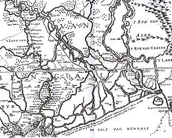
However, there is another explanation for the creation of the depression. The Padma has been changing its course over the centuries. In Ven den Brouck's map of Bengal, prepared in 1660, the main channel of the Padma is shown as flowing through Faridpur
Faridpur District
Faridpur is a district in central Bangladesh. It is a part of the Dhaka Division. Faridpur District has a population of over 1.7 million people and is situated on the banks of the Padma river . It is bordered by Madaripur, Narail, Rajbari, Magura, Shariatpur, Gopalgonj, Dhaka and Manikganj...
-Bakharganj
Barisal District
Barisal is a district in southern Bangladesh. It is also the headquarters of Barisal Division.-Geography and climate:Latitude: 22.75, Longitude: 90.36, Altitude: 4....
, but there also is a suggestion of another, possibly earlier channel. This channel runs through Rampur Boalia in Rajshahi, Chalan Beel, Dhaleswari and Buriganga
Buriganga River
The Buriganga River is the main river flowing beside Dhaka city, capital of Bangladesh. The average depth is and maximum depth is .-History:...
before meeting the Meghna
Meghna River
The Meghna River is an important river in Bangladesh, one of the three that forms the Ganges Delta, the largest on earth fanning out to the Bay of Bengal. Being a part of the Surma-Meghna River System, Meghna is formed inside Bangladesh by the joining of different rivers originaing from the hilly...
. At that time the Jamuna was virtually non-existent and the Brahmaputra
Brahmaputra River
The Brahmaputra , also called Tsangpo-Brahmaputra, is a trans-boundary river and one of the major rivers of Asia. It is the only Indian river that is attributed the masculine gender and thus referred to as a in Indo-Aryan languages and languages with Indo-Aryan influence...
used to flow through its old channel.
Impact of railways
An estimate taken in 1945 found about 47 rivers and other waterways flowed into the Chalan Beel, a watershedDrainage basin
A drainage basin is an extent or an area of land where surface water from rain and melting snow or ice converges to a single point, usually the exit of the basin, where the waters join another waterbody, such as a river, lake, reservoir, estuary, wetland, sea, or ocean...
of about 1547 square miles (4,006.7 km²). In addition to being a crossroads
Interchange
An interchange is a location where two things meet, usually perform some kind of exchange, and possibly go on their ways again. It is used in a number of different contexts...
for the many waterways it also served as the origin for the many rivers flowing south or east that eventually meet with the Padma or Jamuna. In the early 1900s, Chalan Beel began to be hemmed in by the construction of the East Bengal Railway main line on the west and the Santahar-Bogra
Bogra District
Bogra is a northern district of Bangladesh, in the Rajshahi Division. It is called the gateway to the north Bengal. It is an industrial city where many small and mid sized industries are housed. Bogra district was a part of the ancient Pundravardhana territory and Bogra was the capital of...
branch line on the north. The natural pattern of the water's drainage channels in this area were disrupted by the obstruction caused by the railway construction since railways in these low lands had to be built on embankments
Embankment (transportation)
To keep a road or railway line straight or flat, and where the comparative cost or practicality of alternate solutions is prohibitive, the land over which the road or rail line will travel is built up to form an embankment. An embankment is therefore in some sense the opposite of a cutting, and...
.
Flora and fauna
The banks of the beel are covered with dense stands of kash , bablaAcacia nilotica
Acacia nilotica is a species of Acacia native to Africa and the Indian subcontinent...
, nol
Arundo donax
Arundo donax, Giant Cane, is a tall perennial cane growing in damp soils, either fresh or moderately saline. Other common names include Carrizo, Arundo, Spanish cane, Wild cane, and Giant reed....
, dhol kolmi
Ipomoea
Ipomoea is the largest genus in the flowering plant family Convolvulaceae, with over 500 species. Most of these are called "morning glories", but this can refer to related genera also. Those formerly separated in Calonyction are called "moonflowers"...
, simul
Bombax ceiba
Bombax ceiba, like other trees of the genus Bombax, is commonly known as cotton tree or tree cotton. This tropical tree has a straight tall trunk and its leaves are deciduous in winter. Red flowers with 5 petals appear in the spring before the new foliage. It produces a capsule which, when ripe,...
, and date palm
Phoenix sylvestris
Phoenix sylvestris also known as Silver Date Palm or Sugar Date Palm, is a species of flowering plant in the palm family native to southern Pakistan,most of India and Bangladesh. Growing in plains and scrubland to 1300 m, the fruit from this palm species is used to make wine and jelly...
. Seven species of frogs and one species of toad represent the amphibian fauna. Chalan Beel has a total of 34 species of reptiles include ten turtles and tortoises, nine lizards and various snake species. There are 27 species of mammals from 12 families.