
Car Nicobar
Encyclopedia
Nicobar Islands
The Nicobar Islands are an archipelagic island chain in the eastern Indian Ocean...
. It is also one of two local administrative divisions of the Indian district
Districts of India
A district is an administrative division of an Indian state or territory. Districts are further subdivided, in some cases into Sub-Divisions, and otherwise directly into tehsils or talukas.District officials include:...
of Nicobar
Nicobar district
Nicobar district is one of three districts in the Indian Union Territory of Andaman and Nicobar Islands. The district's administrative territory encompasses all of the Nicobar Islands, which are located in the Indian Ocean . The area covered by this district is 1841 km²...
, part of the India
India
India , officially the Republic of India , is a country in South Asia. It is the seventh-largest country by geographical area, the second-most populous country with over 1.2 billion people, and the most populous democracy in the world...
n union territory
Union Territory
A Union Territory is a sub-national administrative division of India, in the federal framework of governance. Unlike the states of India, which have their own elected governments, union territories are ruled directly by the federal government; the President of India appoints an Administrator or...
of Andaman and Nicobar Islands.
The island was ravaged by the 2004 tsunami.
Geography
Car Nicobar falls in between Little AndamanLittle Andaman
Little Andaman island is the fourth largest of the Andaman Islands of India with an area of 734.39 km², lying at the southern end of the archipelago. It is separated from Rutland Island in Great Andaman by the Duncan Passage. It is home to the Onge tribe, who call the island Egu Belong, and...
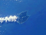
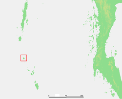
and Nancowrie. The area south to the Ten-degree channel comes under Car Nicobar headquarter. It is a flat fertile island covered with cluster of coconut palms and enchanting beaches with a roaring sea all around.
Compared to the Middle Andaman and South Andaman, Car Nicobar is a small island, having only 127 km². There are 15 villages, the largest of which is named Malacca.
The climate of Car Nicobar Island is tropical, as it is just 9 degree from the equator, with an annual rainfall of 400 mm. The data of past ten year shows that the mean relative humidity in the Island is 79%, and the mean maximum temperature is of 30.20 C, and mean minimum temperature is 23.00 C.
The soil analysis revealed high content of sand & clay hindering the growth of agricultural crops. The area of Car Nicobar is suitable for the plantation crops, and coconut
Coconut
The coconut palm, Cocos nucifera, is a member of the family Arecaceae . It is the only accepted species in the genus Cocos. The term coconut can refer to the entire coconut palm, the seed, or the fruit, which is not a botanical nut. The spelling cocoanut is an old-fashioned form of the word...
and arecanut are the major products, which are grown in the area.
Administration
Politically, Car Nicobar is a tehsilTehsil
A Tehsil or Tahsil/Tahasil , also known as Taluk and Mandal, is an administrative division of some country/countries of South Asia....
, roughly equivalent to a county
County
A county is a jurisdiction of local government in certain modern nations. Historically in mainland Europe, the original French term, comté, and its equivalents in other languages denoted a jurisdiction under the sovereignty of a count A county is a jurisdiction of local government in certain...
in its range of administrative powers. (The tehsil of Nancowry
Nancowry tehsil
Nancowry is one of 2 local administrative divisions of the Indian district of Nicobar, part of the Indian union territory of Andaman and Nicobar Islands....
administers all the other Nicobar islands.) The administrative capital is near the Indian Air Force
Indian Air Force
The Indian Air Force is the air arm of the Indian armed forces. Its primary responsibility is to secure Indian airspace and to conduct aerial warfare during a conflict...
station (1 km) known as head quarters which is the largest junction in this small island with some shops, a hospital, a bank, a post office, the police head quarters and some government offices.
Although the area of Car Nicobar is less than 7% of the area of the Nicobar group, in the census of 2001 its population of 29,145 was more than half of the total Nicobar population.
There were 15 villages, namely, 1)Ha-nyôch (Mus
Mus
-Computing:* Mus, a file extension used by Finale * MUS, the internal music format used in Doom -Three-letter acronyms:* Mitsubishi UFJ Securities * MUS, the NATO country code for Mauritius...
) 2)Töt-chak (Kinmai), 3)Tö-kuö-nö Sē-ti (Small Lapathy) 4)Tö-ki-röng Sē-ti (Big Lapathy) 5)Höng-chu (Tapoiming) 6)Pum-pai (Chukchucha) 7)Sa-rā-ki (Kinyuka) 8)Tim-lö (Tamalu) 9)Kè-è-rô (Perka) 10)U-rèk-ka (Malacca) 11)Sa-pë-ha (Kakana) 12)Öt-ra-höön (Kimius) 13)Ha-ran (Arong) 14)Öt-ka-sip (Sawai
Sawai
Sawai in India, may refer to Honorary title generally used with Bahadur, for example Sawai Bahadur. Sawai literally means a quarter over one .Sawai may also refer to:*Sawai, a language*Sawai, a tropical tree...
) 15)Rit-töp (Titop), {the names in brackets are modern names as the local names Nicobarese are difficult for outsiders to pronounce}, the largest being Malacca (pop. 4,314).
Each village has a tuhet meaning elderly heads, the number of which varies. From each of these elders three are elected as 1st, 2nd, and 3rd captain to look after the day-to-day affairs of the village.
2004 tsunami devastation
Car Nicobar lies 750 km (466 mi) from the epicenterEpicenter
The epicenter or epicentre is the point on the Earth's surface that is directly above the hypocenter or focus, the point where an earthquake or underground explosion originates...
of the 2004 Indian Ocean earthquake
2004 Indian Ocean earthquake
The 2004 Indian Ocean earthquake was an undersea megathrust earthquake that occurred at 00:58:53 UTC on Sunday, December 26, 2004, with an epicentre off the west coast of Sumatra, Indonesia. The quake itself is known by the scientific community as the Sumatra-Andaman earthquake...
, and the ensuing tsunami
Tsunami
A tsunami is a series of water waves caused by the displacement of a large volume of a body of water, typically an ocean or a large lake...
s struck it with great force. Witnesses reported the waves were as high as 30 ft (9 m). As of December 30, 2004, the number of casualties remained unknown, but seemed likely to be high. One survivor told the Associated Press
Associated Press
The Associated Press is an American news agency. The AP is a cooperative owned by its contributing newspapers, radio and television stations in the United States, which both contribute stories to the AP and use material written by its staff journalists...
: "There's not a single hut which is standing. Everything is gone. Most of the people have gone away from the shore and Indian govt has made many relief programmes here such as temporary shelters, subsidize their every primary needs etc.