
California's 1st State Senate district
Encyclopedia
California
's 1st State Senate
District is one of 40 Senate Districts. It is represented by Republican
Ted Gaines
of Roseville
.
border to the Mojave Desert
. It includes most of the Mother Lode
and Sierra Nevada Regions in addition to Lake Tahoe
. However, because most of the district is rural, two-thirds of the district's population in 2000 lived in suburban Sacramento
.
It includes the entirety of Modoc
, Lassen
, Plumas
, Sierra
, Amador
, El Dorado
, Calaveras
, Alpine
, and Mono
Counties. It also contains parts of Nevada County
(including Truckee
), Placer County
(including Auburn
, Colfax
, and Roseville
), and Sacramento County
(including all of Fair Oaks
, Folsom
, Galt
, Gold River
, Orangevale
, Rancho Murrieta, Vineyard
, and Wilton
; and most of Carmichael
, Elk Grove
and Rancho Cordova
).
California
California is a state located on the West Coast of the United States. It is by far the most populous U.S. state, and the third-largest by land area...
's 1st State Senate
California State Senate
The California State Senate is the upper house of the California State Legislature. There are 40 state senators. The state legislature meets in the California State Capitol in Sacramento. The Lieutenant Governor is the ex officio President of the Senate and may break a tied vote...
District is one of 40 Senate Districts. It is represented by Republican
California Republican Party
The California Republican Party is the California affiliate of the United States Republican Party. The party chairman is Tom Del Beccaro and is based in Burbank, California, a suburb of Los Angeles. The RPC also has a headquarters in Sacramento....
Ted Gaines
Ted Gaines
Edward M. Gaines is a California State Senator, representing the 1st Senate district. He won a January 4, 2011, special election to replace the late Dave Cox and took office two days later...
of Roseville
Roseville, California
-2010:The 2010 United States Census reported that Roseville had a population of 118,788. The population density was 3,279.4 people per square mile...
.
District profile
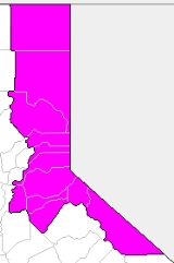
The 1st District stretches along the eastern edge of the state, from the OregonOregon
Oregon is a state in the Pacific Northwest region of the United States. It is located on the Pacific coast, with Washington to the north, California to the south, Nevada on the southeast and Idaho to the east. The Columbia and Snake rivers delineate much of Oregon's northern and eastern...
border to the Mojave Desert
Mojave Desert
The Mojave Desert occupies a significant portion of southeastern California and smaller parts of central California, southern Nevada, southwestern Utah and northwestern Arizona, in the United States...
. It includes most of the Mother Lode
Mother Lode
Mother lode is a principal vein or zone of veins of gold or silver ore. The term probably came from a literal translation of the Spanish veta madre, a term common in old Mexican mining...
and Sierra Nevada Regions in addition to Lake Tahoe
Lake Tahoe
Lake Tahoe is a large freshwater lake in the Sierra Nevada of the United States. At a surface elevation of , it is located along the border between California and Nevada, west of Carson City. Lake Tahoe is the largest alpine lake in North America. Its depth is , making it the USA's second-deepest...
. However, because most of the district is rural, two-thirds of the district's population in 2000 lived in suburban Sacramento
Sacramento
Sacramento is the capital of the state of California, in the United States of America.Sacramento may also refer to:- United States :*Sacramento County, California*Sacramento, Kentucky*Sacramento – San Joaquin River Delta...
.
It includes the entirety of Modoc
Modoc County, California
Modoc County is a county located in the far northeast corner of the U.S. state of California, bounded by the state of Oregon to the north and the state of Nevada to the east. As of the 2010 census, its population was 9,686, up from 9,449 at the 2000 census. The current county seat is Alturas, the...
, Lassen
Lassen County, California
Lassen County is a county located in the northeastern portion of the U.S. state of California. As of the 2010 census, the population was 34,895, up from 33,828 at the 2000 census...
, Plumas
Plumas County, California
Plumas County is a county located in the Sierra Nevada of the U.S. state of California. The county gets its name from the Spanish words for the Feather River , which flows through the county. As of the 2010 census, the population 20,007, down from 20,824 at the 2000 census...
, Sierra
Sierra County, California
Sierra County is a county located in the Sierra Nevada of the U.S. state of California, northeast of Sacramento on the border with Nevada. As of the 2010 census the population was 3,240, down from 3,555 at the 2000 census. The county seat is Downieville....
, Amador
Amador County, California
Amador County is a county located in the Sierra Nevada of the U.S. state of California. As of the 2010 census, the population was 38,091. The county seat is Jackson.Amador County bills itself as "The Heart of the Mother Lode" and lies within the Gold Country...
, El Dorado
El Dorado County, California
El Dorado County is a county located in the historic Gold Country in the Sierra Nevada Mountains and foothills of the U.S. state of California. The 2010 population was 181,058. The El Dorado county seat is in Placerville....
, Calaveras
Calaveras County, California
Calaveras County is a county located in the Gold Country of the U.S. state of California. Calaveras is the Spanish word for skulls; the county was reportedly named for the remains of Native Americans discovered by the Spanish explorer Captain Gabriel Moraga. As of the 2010 census, the county had a...
, Alpine
Alpine County, California
Alpine County is the smallest county, by population, in the U.S. state of California. As of 2010, it had a population of 1,175, all rural. There are no incorporated cities in the county. The county seat is Markleeville...
, and Mono
Mono County, California
Mono County is a county located in the east central portion of the U.S. state of California, to the east of the Sierra Nevada between Yosemite National Park and Nevada. As of the 2010 census, the population was 14,202, up from 12,853 at the 2000 census...
Counties. It also contains parts of Nevada County
Nevada County, California
Nevada County is a county located in the Sierra Nevada of California, in the Mother Lode country. As of 2010 its population was 98,764. The county seat is Nevada City.-History:Nevada County was created in 1851 from parts of Yuba County....
(including Truckee
Truckee, California
Truckee is an incorporated town in Nevada County, California, United States. The population was 16,180 at the 2010 census, up from 13,864 at the 2000 census.-Name:...
), Placer County
Placer County, California
Placer County is a county located in both the Sacramento Valley and Sierra Nevada regions of the U.S. state of California, in what is known as the Gold Country. It stretches from the suburbs of Sacramento to Lake Tahoe and the Nevada border. Because of the expansion of the Greater Sacramento,...
(including Auburn
Auburn, California
Auburn is the county seat of Placer County, California. Its population at the 2010 census was 13,330. Auburn is known for its California Gold Rush history.Auburn is part of the Greater Sacramento area.- History :...
, Colfax
Colfax, California
Colfax is a city in Placer County, California, at the crossroads of Interstate 80 and State Route 174. It is part of the Sacramento–Arden-Arcade–Roseville Metropolitan Statistical Area. The population was 1,963 at the 2010 census...
, and Roseville
Roseville, California
-2010:The 2010 United States Census reported that Roseville had a population of 118,788. The population density was 3,279.4 people per square mile...
), and Sacramento County
Sacramento County, California
Sacramento County is a county in the U.S. state of California. Its county seat is Sacramento, which is also the state capital. As of 2010 the county had a population of 1,418,788....
(including all of Fair Oaks
Fair Oaks, California
Fair Oaks is a census-designated place in Sacramento County, California, United States. It is part of the Sacramento–Arden-Arcade–Roseville Metropolitan Statistical Area. The population was 30,912 at the 2010 census, up from 28,008 at the 2000 census. Fair Oaks's zip code is 95628...
, Folsom
Folsom, California
Folsom is a city in Sacramento County, California, United States. Folsom is most commonly known for its famous Folsom Prison. The population was 72,203 at the 2010 census....
, Galt
Galt, California
Galt is a city in Sacramento County, California, USA. It is part of the Sacramento–Arden-Arcade–Roseville Metropolitan Statistical Area...
, Gold River
Gold River, California
Gold River is a census-designated place in Sacramento County, California. The population was 7,812 at the 2010 census, down from 8,023 at the 2000 census...
, Orangevale
Orangevale, California
Orangevale is a census-designated place in Sacramento County, California, United States. It is part of the Sacramento–Arden-Arcade–Roseville Metropolitan Statistical Area. The population was 33,960 at the 2010 census, up from 26,705 at the 2000 census. It is located approximately ...
, Rancho Murrieta, Vineyard
Vineyard, California
Vineyard is a census-designated place in Sacramento County, California, United States. It is part of the Sacramento–Arden-Arcade–Roseville Metropolitan Statistical Area. The population was 24,836 at the 2010 census, up from 10,109 at the 2000 census...
, and Wilton
Wilton, California
Wilton is a census-designated place in Sacramento County, California, United States. It is part of the Sacramento–Arden-Arcade–Roseville Metropolitan Statistical Area. The population was 5,363 at the 2010 census, up from 4,551 at the 2000 census.-Geography and environment:Wilton is...
; and most of Carmichael
Carmichael, California
Carmichael is a census-designated place in Sacramento County, California, United States. It is part of the Sacramento–Arden-Arcade–Roseville Metropolitan Statistical Area. The population was 61,762 at the 2010 census, up from 49,742 at the 2000 census.-Geography and geology:Carmichael...
, Elk Grove
Elk Grove, California
Elk Grove is a city in Sacramento County, California, located just south of the state capital of Sacramento. It is part of the Sacramento–Arden-Arcade–Roseville Metropolitan Statistical Area. As of the 2010 census, the population of the city is 153,015...
and Rancho Cordova
Rancho Cordova, California
Rancho Cordova is a city in Sacramento County, California, USA, that incorporated in 2003. It is part of the Sacramento Metropolitan Area. The population was 64,776 at the 2010 census. Rancho Cordova is the Sacramento area's largest employment sub-center, with a daily influx of over 45,000...
).
2004
2000
List of representatives
| Representative | Party | Dates | Notes |
|---|---|---|---|
| David B. Kurtz David B. Kurtz David Brown Kurtz , aka Daniel Brown Kurtz, was an American Whig and Democratic politician from California.Kurtz was born 1819 in Pennsylvania. He came to San Diego in 1850 where he studied law. He was admitted to the bar in 1856... |
Whig | ||
| Cameron E. Thom Cameron E. Thom Cameron E. Thom who came to California during the gold rush, was a lawyer, a Confederate officer in the Civil War, and the 16th Mayor of Los Angeles .-California:... |
Democratic | ||
| Jonathan J. Warner | Democratic | ||
| John W. Satterwhite | Democratic | ||
| Benjamin Davis Wilson | Democratic | ||
| J. P. McFarland | Democratic | ||
| Andres Pico Andrés Pico Andrés Pico was a Californio who became a successful rancher, served as a military commander during the Mexican-American War; and was elected to the state assembly and senate after California became a state, when he was also commissioned as a brigadier general in the state militia.-Early... |
Democratic | ||
| John P. Haynes | Democratic | ||
| James N. Gillett | Republican | ||
| A. P. Johnson | Republican | ||
| Frank McGowan Frank McGowan Francis Mark Courtney McGowan , is an independent Scottish film-maker/producer/director, media personality and musician from Glasgow, Scotland, UK.... |
Republican | ||
| John Wolfskill | Democratic | ||
| Frank McGowan Frank McGowan Francis Mark Courtney McGowan , is an independent Scottish film-maker/producer/director, media personality and musician from Glasgow, Scotland, UK.... |
Republican | ||
| Thomas H. Selvage | Republican | 1892–1900 | |
| George T. Rolley | Republican | 1900–1906 | |
| Charles P. Cutten | Republican | 1906–1908 | |
| William Kehoe | Republican | 1908–1912 | |
| H. C. Nelson | Republican | 1912–1920 | |
| Harold J. Powers Harold J. Powers Harold J. Powers was a the 36th Lieutenant Governor of California, having served from 1953-1959 under fellow liberal Republican Governor Goodwin J. Knight.... |
Republican | 1920–1932 | |
| Stanley Arnold | Democratic | 1932–1955 | |
| Randolph Collier | Democratic | 1955–1966 | |
| Ray E. Johnson | Republican | 1966–1976 | |
| John T. Doolittle | Republican | 1976–1984 | |
| Tim Leslie Tim Leslie Robert Timothy Leslie is an American politician from California and a member of the Republican Party.-Early life and education:Born in Ashland, Oregon, Leslie moved to California with his family as a two-year-old... |
Republican | 1984–1991 | |
| Rico Oller Rico Oller Thomas "Rico" Oller is a Republican U.S. politician from California. He served in the California State Assembly, representing the 4th District from 1996 to 2000, and the California State Senate, representing the 1st district from 2000 to 2004... |
Republican | 1991–2000 | |
| Dave Cox Dave Cox David E. Cox was an American politician from Holdenville, Oklahoma. A Republican, he served as a California State Senator, representing the 1st district from December 2004 until his death in July 2010, and also served as an California State Assemblyman for the six years immediately before his... |
Republican | 2000–2010 | |
| Ted Gaines Ted Gaines Edward M. Gaines is a California State Senator, representing the 1st Senate district. He won a January 4, 2011, special election to replace the late Dave Cox and took office two days later... |
Republican | 2011–present |
See also
- California State Senate DistrictsCalifornia State Senate districtsCalifornia's State Senate districts are numbered 1st through 40th.California's 1st State Senate districtCalifornia's 2nd State Senate districtCalifornia's 3rd State Senate districtCalifornia's 4th State Senate districtCalifornia's 5th State Senate district...
- California State SenateCalifornia State SenateThe California State Senate is the upper house of the California State Legislature. There are 40 state senators. The state legislature meets in the California State Capitol in Sacramento. The Lieutenant Governor is the ex officio President of the Senate and may break a tied vote...
- Districts in CaliforniaDistricts in CaliforniaThere are several different types of districts in California. The U.S. state of California is geographically divided into various districts for political and administrative purposes.-Congressional Districts:...