
Calgary-Edmonton Corridor
Encyclopedia
Canada
Canada is a North American country consisting of ten provinces and three territories. Located in the northern part of the continent, it extends from the Atlantic Ocean in the east to the Pacific Ocean in the west, and northward into the Arctic Ocean...
province of Alberta
Alberta
Alberta is a province of Canada. It had an estimated population of 3.7 million in 2010 making it the most populous of Canada's three prairie provinces...
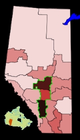
. It is the most urbanized area in Alberta and is one of Canada's four most urban regions. It consists of Statistics Canada
Statistics Canada
Statistics Canada is the Canadian federal government agency commissioned with producing statistics to help better understand Canada, its population, resources, economy, society, and culture. Its headquarters is in Ottawa....
census divisions No. 11
Division No. 11, Alberta
Division No. 11 is a census division in Alberta, Canada. Surrounding the City of Edmonton, the majority of the division comprises Alberta's Capital Region, while the western and southern portions of the division are located within central Alberta...
, No. 8
Division No. 8, Alberta
Division No. 8 is a census division in Alberta, Canada. It is located in the south-central portion of central Alberta and surrounds the City of Red Deer. The division forms the central segment of the Calgary–Edmonton Corridor. Division No...
, and No. 6
Division No. 6, Alberta
Division No. 6 is a census division in Alberta, Canada. Surrounding the City of Calgary, the majority of the division comprises Alberta's Calgary Region, while the northern portion of the division is located within central Alberta. The division also forms the southern segment of the...
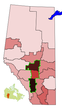
. Measured from north to south, the region covers a distance of approximately 400 km (248.5 mi). It includes the entire census metropolitan areas of Calgary
Calgary
Calgary is a city in the Province of Alberta, Canada. It is located in the south of the province, in an area of foothills and prairie, approximately east of the front ranges of the Canadian Rockies...
and Edmonton
Edmonton
Edmonton is the capital of the Canadian province of Alberta and is the province's second-largest city. Edmonton is located on the North Saskatchewan River and is the centre of the Edmonton Capital Region, which is surrounded by the central region of the province.The city and its census...
and the census agglomerations of Red Deer
Red Deer, Alberta
Red Deer is a city in Central Alberta, Canada. It is located near the midpoint of the Calgary-Edmonton Corridor and is surrounded by Red Deer County. It is Alberta's third-most-populous city – after Calgary and Edmonton. The city is located in aspen parkland, a region of rolling hills...
and Wetaskiwin. According to the 2001 Canadian census
Canada 2001 Census
The Canada 2001 Census was a detailed enumeration of the Canadian population. Census day was May 15, 2001. On that day, Statistics Canada attempted to count every person in Canada. The total population count of Canada was 30,007,094. This was a 4% increase over 1996 Census of 28,846,761. In...
, the population of the Calgary–Edmonton Corridor represented 72.3% of Alberta's population.
Transportation
The Queen Elizabeth II (QE2) Highway (Highway 2), the busiest stretch of highway in Alberta, is the central spine of the Calgary–Edmonton Corridor. A Canadian Pacific rail line runs generally parallel to the QE2 Highway, or its Highway 2A feeder system, between Calgary and Edmonton.The Calgary–Edmonton Corridor has two major international airports – the Calgary International
Calgary International Airport
Calgary International Airport, , is the international airport that serves Calgary, Alberta, Canada and the surrounding region; it is situated approximately northeast of downtown Calgary...
and Edmonton International
Edmonton International Airport
Edmonton International Airport is the primary air passenger and air cargo facility in the Edmonton region in the Canadian province of Alberta. It is a hub facility for Northern Alberta and Northern Canada providing regularly scheduled nonstop flights to over fifty communities in Canada, the United...
. The corridor is one of Canada's busiest commuter flight sectors. Many business people fly return trips in a single business day. Airlines that fly this route include Air Canada
Air Canada
Air Canada is the flag carrier and largest airline of Canada. The airline, founded in 1936, provides scheduled and charter air transport for passengers and cargo to 178 destinations worldwide. It is the world's tenth largest passenger airline by number of destinations, and the airline is a...
and WestJet
WestJet
WestJet Airlines Ltd. is a Canadian low-cost carrier that provides scheduled and charter air service to 71 destinations in Canada, the United States, Mexico and the Caribbean. Founded in 1996, WestJet is currently the second largest Canadian air carrier, behind Air Canada, operating an average of...
having up to approximately 20 and 10 daily flights respectively.
Growth
Petroleum
Petroleum or crude oil is a naturally occurring, flammable liquid consisting of a complex mixture of hydrocarbons of various molecular weights and other liquid organic compounds, that are found in geologic formations beneath the Earth's surface. Petroleum is recovered mostly through oil drilling...
during the early 21st century. A 2003 study by TD Bank Financial Group found the corridor is the only Canadian urban centre to amass a U.S. level of wealth while maintaining a Canadian-style quality of life, offering universal health care benefits. The study found GDP per capita in the corridor is 10% above average U.S. metropolitan areas and 40% above other Canadian cities. Much of this is because of large oil revenues.
Census subdivisions
The following are lists of the census subdivisions within the Calgary Region and Edmonton Capital Region portions of the Calgary–Edmonton Corridor. The Edmonton Capital Region's eight summer villages are not listed.- Calgary RegionCalgary RegionThe Calgary Region is an area centred around Calgary, Alberta, Canada. It consists of the City of Calgary, Rocky View County and the municipalities it encloses, and the Municipal District of Foothills No. 31 and the municipalities it encloses. The Calgary Census Metropolitan Area and Calgary...
- AirdrieAirdrie, AlbertaAirdrie is a city in Alberta, Canada, located just north of Calgary within the Calgary–Edmonton Corridor. The City of Airdrie is part of Calgary's Census Metropolitan Area and a member community of the Calgary Regional Partnership . Due to its proximity to Calgary, Airdrie's population has been...
- BeisekerBeiseker, AlbertaBeiseker is a village in the Province of Alberta, Canada. It is approximately northeast of Calgary. It is considered to be an outermost part of the Calgary Region and is included within Calgary's Census Metropolitan Area...
- Black DiamondBlack Diamond, AlbertaBlack Diamond is a sister town to Turner Valley. There exists a three-kilometer trail next to the roadway between Black Diamond and Turner Valley named the Friendship Trail. It has a hospital, shops, hotels and residences, an elementary school [K-6] and highschool [7-12] as well a hockey rink and...
- CalgaryCalgaryCalgary is a city in the Province of Alberta, Canada. It is located in the south of the province, in an area of foothills and prairie, approximately east of the front ranges of the Canadian Rockies...
- ChestermereChestermere, AlbertaChestermere is a town adjacent to the City of Calgary in the Province of Alberta, Canada within Rocky View County. It is largely a bedroom community of Calgary and is a member municipality of the Calgary Regional Partnership...
- CochraneCochrane, AlbertaCochrane is a town in the Canadian province of Alberta. The town is located 18 km west of the Calgary city limits along Highway 1A. With a population of 15,424 , Cochrane is the second largest town in Alberta and one of the fastest growing communities in Canada...
- CrossfieldCrossfield, AlbertaCrossfield is a town in southern Alberta, Canada within Rocky View County.Crossfield is located 43 kilometers or north of the City of Calgary, on Highway 2....
- Eden Valley 216Eden Valley 216Eden Valley 216 is an Indian reserve located near Longview, Alberta. It is shared by the Bearspaw, Chiniki, and Wesley bands of the Nakoda nation.-References:...
(Stoney First Nation) - Foothills No. 31, Municipal District ofFoothills No. 31, AlbertaThe Municipal District of Foothills No. 31 is a municipal district in southern Alberta, Canada adjacent to the south side of Calgary in Census Division No. 6...
- High RiverHigh River, AlbertaHigh River is a town in southwestern Alberta, Canada with a population of 10,716. It is south of the city of Calgary, at the junction of Alberta Highways 2 and 23...
- IrricanaIrricana, AlbertaIrricana is a town in southern Alberta, Canada. It is located in the wide-open spaces of the Canadian prairies, northeast of Calgary, and west of the Drumheller badlands off Highway 9....
- LongviewLongview, AlbertaLongview is a village in southern Alberta, Canada. It is located in the Canadian Rockies foothills, on Cowboy Trail, 32 km west of High River and 64 km south of Calgary...
- OkotoksOkotoks, AlbertaOkotoks is a town situated on the Sheep River, south of Calgary, Alberta, Canada. The town is a member of the Calgary Regional Partnership, a cooperative of communities within the Calgary Region. Okotoks has become a popular bedroom community for the City of Calgary...
- Rocky View County
- Tsuu T'ina Nation 145Tsuu T'ina Nation 145, AlbertaTsuu T'ina Nation 145 is the name of an Indian reserve in southern Alberta, Canada. It is the home of the Tsuu T'ina Nation. The reserve was created by Treaty 7. Reserve lands are between Southwest Calgary, Alberta in the east and Bragg Creek, Alberta in the west. The north boundary is just...
(Tsuu T'ina NationTsuu T'ina NationThe Tsuu T'ina Nation is a First Nation in Canada. Their territory is located on the Indian reserve Tsuu T'ina Nation 145, whose east side is adjacent to the southwest city limits of Calgary, Alberta...
) - Turner ValleyTurner Valley, AlbertaTurner Valley is a town in Alberta, Canada. It is located southwest of Calgary.Situated on Highway 22 , the town was once the centre of an oil and natural gas boom. For 30 years, the Turner Valley Oilfields was a major supplier of oil and gas and the largest producer in the British Empire, but is...
- Airdrie
- Edmonton Capital RegionEdmonton Capital RegionThe Edmonton Capital Region , also commonly referred to as the Alberta Capital Region, Greater Edmonton or Metro Edmonton, is a conglomeration of municipalities centred around Edmonton – Alberta's provincial capital....
- Alexander 134Alexander 134, AlbertaAlexander 134 is an Indian reserve located in Sturgeon County, Alberta. Northwest of the city of Edmonton. It is one of the four reserves of the Alexander First Nation, a Cree, Treaty 6 nation....
(Alexander First NationAlexander First NationAlexander First Nation is a First Nation government , headquartered in Morinville, Alberta. This First Nation is part of the Cree ethno-linguistic group, is a member of the Yellowhead Tribal Development Foundation , and is party to Treaty Six. The band controls three Indian reserves: Alexander...
) - Beaumont
- Bon AccordBon Accord, AlbertaBon Accord is a town in central Alberta, Canada. It is located north of downtown Edmonton on highway 28.-Demographics:In 2006, Bon Accord had a population of 1,534 living in 500 dwellings, a 0.1% increase from 2001. The town has a land area of and a population density of .-External links:*...
- BruderheimBruderheim, AlbertaBruderheim is a town in central Alberta, Canada. It is located just north of the junction of Highway 15 and Highway 45, north-east of Edmonton.-Demographics:...
- CalmarCalmar, AlbertaCalmar is a town in central Alberta, Canada. It is located in Leduc County, on Highway 39, south-west from Edmonton.-Demographics:The population of the Town of Calmar according to its 2009 municipal census is 2,033....
- DevonDevon, AlbertaDevon is a town in the province of Alberta, Canada, situated southwest of Edmonton, the provincial capital, and located along the banks of the North Saskatchewan River.- History :Devon owes its existence to one of the largest oil discoveries in the world...
- EdmontonEdmontonEdmonton is the capital of the Canadian province of Alberta and is the province's second-largest city. Edmonton is located on the North Saskatchewan River and is the centre of the Edmonton Capital Region, which is surrounded by the central region of the province.The city and its census...
- Fort Saskatchewan
- Gibbons
- LeducLeduc, Alberta- Demographics :The population of the City of Leduc according to its 2011 municipal census is 24,139, a 3.6% increase over its 2010 municipal census population of 23,293....
- Leduc CountyLeduc County, AlbertaLeduc County is a municipal district located immediately south of the City of Edmonton. It is east to west and north to south, and has a population of over 12,000 people. The municipal district is home to scenic prairie parkland and several lakes...
- Legal
- MorinvilleMorinville, AlbertaMorinville is a town in central Alberta, Canada. It is located north of Edmonton on Highway 2.- History :Morinville was settled by Father Morin, an Oblate missionary, who brought many French settlers in the late 1800s, followed by several German pioneers—hence its many French and German families...
- Parkland CountyParkland County, AlbertaParkland County is a municipal district in central Alberta, Canada.It is located west of Edmonton in Census Division No. 11, along the Parkland Highway...
- RedwaterRedwater, AlbertaRedwater is a town in northern Alberta, Canada. It is located north of Edmonton on Highway 38, in Sturgeon County. Its population, as of 2006, was 2,192.Redwater is placed in the federal riding of Westlock—St...
- Spring LakeSpring Lake, AlbertaSpring Lake is a village in central Alberta, Canada. It is located on the eastern shore of Spring Lake, 20 km west of Spruce Grove and 40 km west of the city of Edmonton...
- Spruce Grove
- St. AlbertSt. Albert, AlbertaSt. Albert is a suburban city in Alberta, located northwest of Edmonton, on the Sturgeon River. It was originally settled as a Métis community, and is now the second largest city in the Edmonton area. St...
- Stony PlainStony Plain, AlbertaStony Plain is a large town in rural Alberta, Canada, just west of Edmonton.Stony Plain is a rapidly growing town with strong historical roots. It is located west of Spruce Grove and surrounded by Parkland County. The town is governed by one mayor and six councillors. The region is dominated by...
- Stony Plain 135 (Enoch Cree Nation)
- Strathcona CountyStrathcona County, AlbertaStrathcona County is a specialized municipality in central Alberta, Canada between Edmonton and Elk Island National Park.It is located in Division No. 11 and is also part of the Edmonton Census Metropolitan Area. More than half of the population lives in Sherwood Park, a large community east of...
- Sturgeon CountySturgeon County, AlbertaSturgeon County is a municipal district in Alberta's Edmonton Capital Region, Canada.It begins at the north end of Edmonton, with 97th street turning into Highway 28. It extends east to Fort Saskatchewan and west to Calahoo. It is located in Division No. 11....
- ThorsbyThorsby, AlbertaThorsby is a village in central Alberta, Canada. It is located 38 km west of the city of Leduc, along Highway 39. Pigeon Lake and Pigeon Lake Provincial Park are located 20 km south of the community.- Demographics :...
- WabamunWabamun, AlbertaWabamun is a village located west of Edmonton in central Alberta, Canada.- Demographics :The population of the Village of Wabamun according to its 2009 municipal census is 662....
- WarburgWarburg, AlbertaWarburg is a village in central Alberta, Canada. It is located 58 km west of the city of Leduc, along Highway 39.-Demographics:The population of the Village of Warburg according to its 2009 municipal census is 696....
- Wabamun 133A & 133B (Paul First Nation)Paul BandThe Paul First Nation, more commonly known as the Paul Band, is a First Nation community or band based in Wabamun, Alberta of mixed Cree and Nakota origin. They are party to Treaty Six and had the Buck Lake Indian Reserve 133C and Wabamun Lake Indian Reserve 133A, 133B and 133C allocated to them...
- Alexander 134
See also
- List of census divisions of Alberta
- Golden HorseshoeGolden HorseshoeThe Golden Horseshoe is a densely populated and industrialized region centred around the Greater Toronto Area at the western end of Lake Ontario in Southern Ontario, Canada, with outer boundaries stretching south to Lake Erie and north to Georgian Bay. Most of it is also part of the Quebec City...
, OntarioOntarioOntario is a province of Canada, located in east-central Canada. It is Canada's most populous province and second largest in total area. It is home to the nation's most populous city, Toronto, and the nation's capital, Ottawa.... - Greater Montreal, QuebecQuebecQuebec or is a province in east-central Canada. It is the only Canadian province with a predominantly French-speaking population and the only one whose sole official language is French at the provincial level....
- Quebec City – Windsor Corridor
- Lower MainlandLower MainlandThe Lower Mainland is a name commonly applied to the region surrounding and including Vancouver, British Columbia, Canada. As of 2007, 2,524,113 people live in the region; sixteen of the province's thirty most populous municipalities are located there.While the term Lower Mainland has been...
and Southern Vancouver IslandVancouver IslandVancouver Island is a large island in British Columbia, Canada. It is one of several North American locations named after George Vancouver, the British Royal Navy officer who explored the Pacific Northwest coast of North America between 1791 and 1794...
, British ColumbiaBritish ColumbiaBritish Columbia is the westernmost of Canada's provinces and is known for its natural beauty, as reflected in its Latin motto, Splendor sine occasu . Its name was chosen by Queen Victoria in 1858... - MegacityMegacityA megacity is usually defined as a metropolitan area with a total population in excess of 10 million people. Some definitions also set a minimum level for population density . A megacity can be a single metropolitan area or two or more metropolitan areas that converge. The terms conurbation,...
- MegalopolisMegalopolis (city type)A megalopolis is typically defined as a chain of roughly adjacent metropolitan areas. The term was used by Oswald Spengler in his 1918 book, The Decline of the West, and Lewis Mumford in his 1938 book, The Culture of Cities, which described it as the first stage in urban overdevelopment and...
- High-speed rail in CanadaHigh-speed rail in CanadaCanada is the only G8 country that does not have high-speed rail. In the press and popular discussion, there have been two routes frequently proposed as suitable for a high-speed rail corridor:* Edmonton to Calgary via Red Deer...