
Bybrook River
Encyclopedia
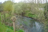
The Bybrook, also known as the By Brook is a tributary of the Bristol Avon, some 12 miles (19.3 km) long. The sources are the Burton Brook and the Broadmead Brook, which rise in South Gloucestershire
at Tormarton
and Cold Ashton
respectively. They join just north of Castle Combe
in Wiltshire
. The river has a mean flow rate of 57.25 cuft/s as recorded at Middlehill near Box
. A variety of flora and fauna is supported by the river including the endangered White-clawed Crayfish
. Twenty watermill
sites have been identified on the river, but none now remain in use.
and runs in an easterly direction towards the village of Burton
on the Gloucestershire-Wiltshire border. The Broadmead Brook rises at Folly Farm at Cold Ashton
and runs eastwards south of the Burton Brook and the two join below Gatcombe Hill, just north of the Wiltshire village of Castle Combe
, at the beginning of a steep valley.
The Bybrook now flows southwards towards the village of Ford
. Just before the village, the Danscombe Brook and another un-named tributary join on the right bank from North Wraxall
and Colerne Airfield
. On through Slaughterford and turning southwards the Bybrook is joined on the right bank by the Lid at Drewett's Mill, north of Box
. The stream now runs in a south westerly direction through a shallower valley, past Shockerwick House
, before joining the Bristol Avon at Bathford
, at a point adjacent to the main railway line from London
and the A4 road
.
Fulling mills were established by Sir John Fastolf
in Castle Combe, along the brook, in the thirteenth and fourteenth centuries, supporting a thriving woollen industry.
With the decline of the woollen industry in the 17th century, accelerated by the Civil War and plague, many mills returned to grain, and fulling finally ceased when steam power shifted cloth-making to the north in the Industrial Revolution. The rise in demand for paper for packaging from nearby Bristol
led to many mills in the 18th and 19th centuries converting to paper making.
In common with other nearby rivers watermill
s were used for grinding corn in the past, but none now remain in use. Chapps Mill paper mill, which is associated with Slaughterford although it is in Colerne parish, continued in production until the 1990s, mainly under the Dowdings,
Goulters Mill, also known as Littleton Mill (1773) was a corn mill mentioned in the Domesday Book
. A corn mill dating from Saxon times.
Gatcombe Mill, also known as Gadcombe Mill, was of greater significance than Goulters Mill. It was known to be a corn mill in 1887 and continued in use until the 1920s. There is no evidence of use other than to grind corn, but the proximity to Castle Combe
raises the possibility of earlier cloth industry unless water was insufficient.
Tanners Mill, also known as Old Mill (1887), which dates back to at least 1773, is now incorporated in the buildings of Lower Shirehill Farm. Due to inadequacy of water supply, this must have been a seasonal corn mill.
West Kington Mill. Its size and age seem to be similar to Gatcombe Mill. In 1887 it was a corn mill that also housed a shoemaker and a butcher shop.
Wick Mill, also known as Longs or Langs Mill and Hennars Mill. This was derelict by 1887. In 1704, three mills in the parish of North Wraxall paid tithes - Doncombe Mill 4s, Ford Mill 3s 4d and Hennars Mill 4s. A cloth mill in 1802, by 1829 it became a grist mill.
Nettleton Mill is part of the Castle Combe estate. The buildings date from the 18th century. A grist mill, its undershot wheel was replaced by a turbine during the 19th century. In the 1950s and 60s, the turbine power was utilised at some time, probably when the stream flow became inadequate.
Castle Combe Mill. The stepping stone weir and sluice are all that remain, in the gardens of the Manor House Hotel.
Upper Colham Mill. A barn on the old mill site is reported to have been a weaving shed. A turbine was in use in the 20th century for a sawmill on the opposite bank from the mill.
Lower Colham Mill declined in importance with the demise of the wool trade. Racks of cloth would have been taken across the bank from both Colham Mills to dry on the significantly named Rack Hill, now a nature reserve.
Upper Long Dean Mill is reported to have been a blanket mill prior to the First World War, It was then a flour mill, and changed to a grist mill until it ceased operation in 1956. Its undershot wheel is still in place and the rooms inside its mansard roof show evidence of the weavers who used to work there.
Lower Long Dean Mill was built as a paper mill by a Bristol merchant, Thomas Wilde (or Wyld) in 1635. Paper was still being manufactures in 1746 and 1860, but by 1887 it was listed as a corn mill. The track along the valley from Long Dean to the A420 has two strong bridges and paved sections, which suggest it was the common route for transporting the paper to the Bristol Road. The mill was destroyed by fire in the 19th century caused, as local legend would have it, by a boiler exploding, hurling its tenderer, a young lad, across the brook into Chapel Wood. The well for the water wheel remains, as does the remains of a hatchway in what was the passageway underneath the drying house. Through this hatchway, the local doctor from Castle Combe
dispensed medicine to his Long Dean patients in the second half of the 19th century. Straddling the millstream downstream from the mill is a unique stone built privy with seating for two adults and one child at once.
Ford Mill in 1725 was a fulling mill, gig mill, and grist mill, with racks, a furnace, presses and workhouses. In 1778, when it was rebuilt, it was a grist mill. by 1784 it was large enough for a paper mill to be added.
Doncombe Mill. Paying a tithe of 4s in 1704, the mill was probably a fulling mill by then, and earlier could have been a fulling mill. In 1778, with the local industry in decline, owner Benjamin Edwards overstretched himself by building six new tenements (still existing as the stable block, Doncobe Mill Cottage) adjoining his fulling and gig mill. He became bankrupt and in 1793 Charles Ward was the owner, and soon the partnership of Cottle and Ward were making paper. In 1847, the mill became a corn mill. The water in Doncombe Brook is less reliable than the By Brook, and the mill needed a reservoir covering two thirds of an acre to regulate the supply. This survives as a pond behind the mill house.
Rag Mill in Slaughterford, also known as Overshot Mill. A mill leat, now filled in, ran for over three quarters of a kilometre from the sluices just downstream of the Doncombe Brook confluence to an overshot wheel in a fulling mill on this site. In the 1890s, rag processing machinery was installed at he mill, and the undershot wheel, which can still be seen on the derelict site dates from that time, being served by a much shorter leat from the next sluice upstream from the mill. Also clearly identifiable on the site is the remains of a rag boiler. The mill, demolished in 1964, processed rags into individual fibres or "stuff", which was transported in vats of elm across the bridge to Chapps Mill for paper making. The water wheel power was supplemented by a gas engine, and ran shafts and pulleys to a cutting machine and conveyor belt, as well as a grindstone to sharpen the cutting machine blades.
Chapps Mill was a fulling Mill until 1790, when Charles Ward of Doncombe Mill took over from the Drewett family, clothiers of Colerne
and Batheaston
. Charles Ward and partner William Duckett converted the mill to paper. In 1805, Charles Ward was found guilty of producing unstamped paper and the sheriff confiscated all his goods. By 1818, the mill had been converted to cloth and the paper machinery was put up for sale. By 1827 the mill was back to paper making , until it was closed under W J Dowding in 1994. The By Brook approaching the mill is man made at a high level and wider than the natural brook to provide a reservoir of water.
Weavern Mill. No mill buildings remain adjacent to the now derelict Weavern Farm, only the sluice opening can be seen at the original location. The name Weavern is a corruption of Wavering, by which the meandering By brook was known at this location. The mill was originally a fulling mill. In 1728 it was described as a corn mill, and in 1793 as a paper mill. It ceased work in 1834.
Widdenham Mill was a fulling mill until 1662, and then it lay derelict until the 18th century, when it returned to fulling until 1767, during which it was also a nap mill and had its own shearshop. in 1770 it was also dyeing its own cloth. Between 187 and 1866 the mill produced brown, blue and sugar paper.
Drewetts Mill was in working order as recently as 1990. The mill originally operated an overshot wheel driving three grindstones. In recent times, power to operate two stones and a saw has been through a vertical turbine.
Box Mill (also known as Pinchin's Mill) was in 1864 part of the Box Brewery owned by the Pinchins who in that year closed their Northgate Brewery at Pulteny Bridge. In 1867 it was described as a corn mill and malthouse. The mill was bought from Spafax in 1987 by musician Peter Gabriel
, and converted into his internationally famous Real World recording studios.
Cuttings Mill. Nothing is known of this mill, which was a casualty of the Great Western Railway
, ending up under the embankment between Middlehill Tunnel and Box
Station
Shockerwick Mills. Two mills are included in a 1270 deed, and one in a 1275 deed, but nothing is known of them, although a weir and sluice arrangement does exist today just south of the road bridge to Shockerwick
Bathford Mill, also known as Forde Mills, Gamage Mills and Trevarno Mill. Mentioned in the Domesday Book
, in the 16th century this was a grist and fulling mill. In 1740, the then miller sent some water from a newly discovered spring to Oxford, where it was judged to contain minerals/ The spring was dubbed "Bathford Spaw", and the miller sold his estate to Dr William Oliver
, creator of the Bath Oliver
biscuit and founder of the Rheumatic Hospital. Dr Oliver named the mill Trevarno. In 1768, James Yeeles, a skinner, converted the mill to a leather mill. On his death, his sons converted it to paper making. In 1882 it suffered in that year's major flooding, whilst in 1884 a great deal of it was destroyed by a boiler explosion. Finally it was completely rebuilt after a fire in 1910. In 1913 it changed from water power to steam power, for 50 years. Since 1971, behind high security fencing, Portals have produced high quality paper used by financial institutions in Europe.
, native White-clawed Crayfish
and Dippers. The crayfish are under threat from the invasive species
American Signal Crayfish
. Miller's thumbs
and lamprey
s also are to be found in the waters. Grey Wagtail
, Kingfisher
and Reed Bunting
can also be seen in the river near Box. Just south of Slaughterford the river passes between two Sites of Special Scientific Interest at Colerne Park and Monk's Wood
and Honeybrook Farm
. These environments contain many rare meadow and aquatic plants including meadowsweet
, common meadow-rue
, hemlock water-dropwort
and golden-saxifrage
.
measures flow rates in the Bybrook at Middlehill, near Box
. The mean flow rate is 57.25 cuft/s. A peak flow of 487.6 cuft/s was recorded on 2 January 2003 and a minimum flow of 4.95 cuft/s on 18 September 1990.
Despite its input of runoff from the M4 motorway, the water quality along the whole of its length is A1.
South Gloucestershire
South Gloucestershire is a unitary district in the ceremonial county of Gloucestershire, in South West England.-History:The district was created in 1996, when the county of Avon was abolished, by the merger of former area of the districts of Kingswood and Northavon...
at Tormarton
Tormarton
Tormarton is a village in South Gloucestershire, England. Its name comes from Thor Maer Tun meaning The settlement with the thorn on the boundary. It is one mile North-East of junction 18 of the M4 motorway, with the A46 road and close to the border between Wiltshire and South Gloucestershire. As...
and Cold Ashton
Cold Ashton
Cold Ashton is a village in South Gloucestershire, England. The village church has a 14th century tower and the rest of the church was rebuilt in the 16th century by Thomas Key, its rector....
respectively. They join just north of Castle Combe
Castle Combe
Castle Combe is a small village in Wiltshire, England, with a population of about 350. It is renowned for its attractiveness and tranquillity, and for fine buildings including the medieval church. The 14th century market cross, erected when the privilege to hold a weekly market in Castle Combe was...
in Wiltshire
Wiltshire
Wiltshire is a ceremonial county in South West England. It is landlocked and borders the counties of Dorset, Somerset, Hampshire, Gloucestershire, Oxfordshire and Berkshire. It contains the unitary authority of Swindon and covers...
. The river has a mean flow rate of 57.25 cuft/s as recorded at Middlehill near Box
Box
Box describes a variety of containers and receptacles for permanent use as storage, or for temporary use often for transporting contents. The word derives from the Greek πύξος , "box, boxwood"....
. A variety of flora and fauna is supported by the river including the endangered White-clawed Crayfish
Austropotamobius pallipes
Austropotamobius pallipes is an endangered European freshwater crayfish, and the only species of crayfish native to the British Isles. Its common names include white-clawed crayfish and Atlantic stream crayfish.-Distribution and ecology:...
. Twenty watermill
Watermill
A watermill is a structure that uses a water wheel or turbine to drive a mechanical process such as flour, lumber or textile production, or metal shaping .- History :...
sites have been identified on the river, but none now remain in use.
Course
The Burton Brook rises near Lower Lapdown Farm at TormartonTormarton
Tormarton is a village in South Gloucestershire, England. Its name comes from Thor Maer Tun meaning The settlement with the thorn on the boundary. It is one mile North-East of junction 18 of the M4 motorway, with the A46 road and close to the border between Wiltshire and South Gloucestershire. As...
and runs in an easterly direction towards the village of Burton
Burton, Wiltshire
Burton is a small village with 96 households in the Cotswolds Area of Outstanding Natural Beauty in England. Kelly's Directory of Wiltshire of 1915 identifies Burton as the most important part of the parish of Nettleton...
on the Gloucestershire-Wiltshire border. The Broadmead Brook rises at Folly Farm at Cold Ashton
Cold Ashton
Cold Ashton is a village in South Gloucestershire, England. The village church has a 14th century tower and the rest of the church was rebuilt in the 16th century by Thomas Key, its rector....
and runs eastwards south of the Burton Brook and the two join below Gatcombe Hill, just north of the Wiltshire village of Castle Combe
Castle Combe
Castle Combe is a small village in Wiltshire, England, with a population of about 350. It is renowned for its attractiveness and tranquillity, and for fine buildings including the medieval church. The 14th century market cross, erected when the privilege to hold a weekly market in Castle Combe was...
, at the beginning of a steep valley.
The Bybrook now flows southwards towards the village of Ford
Ford, Wiltshire
Ford is a small village located in the northwest of Wiltshire. It had a population of 580 in the 2001 census. The village is situated along a small stretch of the A420 road, lying 11 miles east of Bristol and 4 miles west of Chippenham....
. Just before the village, the Danscombe Brook and another un-named tributary join on the right bank from North Wraxall
North Wraxall
North Wraxall is a small village and a civil parish in Wiltshire, England.-Location:The village is located west of Chippenham, on the A420 road going to Bristol.The neighbouring villages are...
and Colerne Airfield
Colerne Airfield
Colerne Airfield , formerly known as RAF Colerne, is located at Colerne, Wiltshire, England.By October 1940 RAF Colerne was still partly in the course of construction being a fighter station for the defence of Bristol. At that date the contractors were still building and the ground was a quagmire...
. On through Slaughterford and turning southwards the Bybrook is joined on the right bank by the Lid at Drewett's Mill, north of Box
Box
Box describes a variety of containers and receptacles for permanent use as storage, or for temporary use often for transporting contents. The word derives from the Greek πύξος , "box, boxwood"....
. The stream now runs in a south westerly direction through a shallower valley, past Shockerwick House
Shockerwick House
Shockerwick House in Bathford, Somerset, England was built as a manor house around 1750 by John Wood the Elder. It has been designated as a Grade I listed building....
, before joining the Bristol Avon at Bathford
Bathford
Bathford is a village and civil parish east of Bath, England. The parish, which includes Warleigh has a population of 1,753, and extends over .-History:...
, at a point adjacent to the main railway line from London
Great Western Main Line
The Great Western Main Line is a main line railway in Great Britain that runs westwards from London Paddington station to the west of England and South Wales. The core Great Western Main Line runs from London Paddington to Temple Meads railway station in Bristol. A major branch of the Great...
and the A4 road
A4 road
The A4 is a major road in England, portions of which are known as the Great West Road and Bath Road. It runs from London to Avonmouth, near Bristol. Historically the road was the main route from London to the west of England, and has formed the second main western artery from London, after...
.
The Mills of the ByBrook
There is evidence of at least 20 mill sites down the Brook. Many of these mills were seasonal and only operated when there was sufficient water., and the history of the valley is very much the history of these mills. In Roman times, the mills were exclusively used for grinding corn, but by the end of the 12th century, this part of Wiltshire became an important centre for the growing wool trade. Mills were converted to the cleansing and thickening of wool - a process known as fulling.Fulling mills were established by Sir John Fastolf
John Fastolf
Sir John Fastolf KG was an English knight during the Hundred Years War, who has enjoyed a more lasting reputation as in some part being the prototype of Shakespeare's Sir John Falstaff...
in Castle Combe, along the brook, in the thirteenth and fourteenth centuries, supporting a thriving woollen industry.
With the decline of the woollen industry in the 17th century, accelerated by the Civil War and plague, many mills returned to grain, and fulling finally ceased when steam power shifted cloth-making to the north in the Industrial Revolution. The rise in demand for paper for packaging from nearby Bristol
Bristol
Bristol is a city, unitary authority area and ceremonial county in South West England, with an estimated population of 433,100 for the unitary authority in 2009, and a surrounding Larger Urban Zone with an estimated 1,070,000 residents in 2007...
led to many mills in the 18th and 19th centuries converting to paper making.
In common with other nearby rivers watermill
Watermill
A watermill is a structure that uses a water wheel or turbine to drive a mechanical process such as flour, lumber or textile production, or metal shaping .- History :...
s were used for grinding corn in the past, but none now remain in use. Chapps Mill paper mill, which is associated with Slaughterford although it is in Colerne parish, continued in production until the 1990s, mainly under the Dowdings,
Goulters Mill, also known as Littleton Mill (1773) was a corn mill mentioned in the Domesday Book
Domesday Book
Domesday Book , now held at The National Archives, Kew, Richmond upon Thames in South West London, is the record of the great survey of much of England and parts of Wales completed in 1086...
. A corn mill dating from Saxon times.
Gatcombe Mill, also known as Gadcombe Mill, was of greater significance than Goulters Mill. It was known to be a corn mill in 1887 and continued in use until the 1920s. There is no evidence of use other than to grind corn, but the proximity to Castle Combe
Castle Combe
Castle Combe is a small village in Wiltshire, England, with a population of about 350. It is renowned for its attractiveness and tranquillity, and for fine buildings including the medieval church. The 14th century market cross, erected when the privilege to hold a weekly market in Castle Combe was...
raises the possibility of earlier cloth industry unless water was insufficient.
Tanners Mill, also known as Old Mill (1887), which dates back to at least 1773, is now incorporated in the buildings of Lower Shirehill Farm. Due to inadequacy of water supply, this must have been a seasonal corn mill.
West Kington Mill. Its size and age seem to be similar to Gatcombe Mill. In 1887 it was a corn mill that also housed a shoemaker and a butcher shop.
Wick Mill, also known as Longs or Langs Mill and Hennars Mill. This was derelict by 1887. In 1704, three mills in the parish of North Wraxall paid tithes - Doncombe Mill 4s, Ford Mill 3s 4d and Hennars Mill 4s. A cloth mill in 1802, by 1829 it became a grist mill.
Nettleton Mill is part of the Castle Combe estate. The buildings date from the 18th century. A grist mill, its undershot wheel was replaced by a turbine during the 19th century. In the 1950s and 60s, the turbine power was utilised at some time, probably when the stream flow became inadequate.
Castle Combe Mill. The stepping stone weir and sluice are all that remain, in the gardens of the Manor House Hotel.
Upper Colham Mill. A barn on the old mill site is reported to have been a weaving shed. A turbine was in use in the 20th century for a sawmill on the opposite bank from the mill.
Lower Colham Mill declined in importance with the demise of the wool trade. Racks of cloth would have been taken across the bank from both Colham Mills to dry on the significantly named Rack Hill, now a nature reserve.
Upper Long Dean Mill is reported to have been a blanket mill prior to the First World War, It was then a flour mill, and changed to a grist mill until it ceased operation in 1956. Its undershot wheel is still in place and the rooms inside its mansard roof show evidence of the weavers who used to work there.
Lower Long Dean Mill was built as a paper mill by a Bristol merchant, Thomas Wilde (or Wyld) in 1635. Paper was still being manufactures in 1746 and 1860, but by 1887 it was listed as a corn mill. The track along the valley from Long Dean to the A420 has two strong bridges and paved sections, which suggest it was the common route for transporting the paper to the Bristol Road. The mill was destroyed by fire in the 19th century caused, as local legend would have it, by a boiler exploding, hurling its tenderer, a young lad, across the brook into Chapel Wood. The well for the water wheel remains, as does the remains of a hatchway in what was the passageway underneath the drying house. Through this hatchway, the local doctor from Castle Combe
Castle Combe
Castle Combe is a small village in Wiltshire, England, with a population of about 350. It is renowned for its attractiveness and tranquillity, and for fine buildings including the medieval church. The 14th century market cross, erected when the privilege to hold a weekly market in Castle Combe was...
dispensed medicine to his Long Dean patients in the second half of the 19th century. Straddling the millstream downstream from the mill is a unique stone built privy with seating for two adults and one child at once.
Ford Mill in 1725 was a fulling mill, gig mill, and grist mill, with racks, a furnace, presses and workhouses. In 1778, when it was rebuilt, it was a grist mill. by 1784 it was large enough for a paper mill to be added.
Doncombe Mill. Paying a tithe of 4s in 1704, the mill was probably a fulling mill by then, and earlier could have been a fulling mill. In 1778, with the local industry in decline, owner Benjamin Edwards overstretched himself by building six new tenements (still existing as the stable block, Doncobe Mill Cottage) adjoining his fulling and gig mill. He became bankrupt and in 1793 Charles Ward was the owner, and soon the partnership of Cottle and Ward were making paper. In 1847, the mill became a corn mill. The water in Doncombe Brook is less reliable than the By Brook, and the mill needed a reservoir covering two thirds of an acre to regulate the supply. This survives as a pond behind the mill house.
Rag Mill in Slaughterford, also known as Overshot Mill. A mill leat, now filled in, ran for over three quarters of a kilometre from the sluices just downstream of the Doncombe Brook confluence to an overshot wheel in a fulling mill on this site. In the 1890s, rag processing machinery was installed at he mill, and the undershot wheel, which can still be seen on the derelict site dates from that time, being served by a much shorter leat from the next sluice upstream from the mill. Also clearly identifiable on the site is the remains of a rag boiler. The mill, demolished in 1964, processed rags into individual fibres or "stuff", which was transported in vats of elm across the bridge to Chapps Mill for paper making. The water wheel power was supplemented by a gas engine, and ran shafts and pulleys to a cutting machine and conveyor belt, as well as a grindstone to sharpen the cutting machine blades.
Chapps Mill was a fulling Mill until 1790, when Charles Ward of Doncombe Mill took over from the Drewett family, clothiers of Colerne
Colerne
Colerne is a village and civil parish in the Cotswolds Area of Outstanding Natural Beauty, midway between Bath and Chippenham in Wiltshire, England. It has an elevated position above sea level and overlooks the Box Valley to the south...
and Batheaston
Batheaston
Batheaston is a village and civil parish east of Bath, England , on the north bank of the River Avon. The parish has a population of 2,625...
. Charles Ward and partner William Duckett converted the mill to paper. In 1805, Charles Ward was found guilty of producing unstamped paper and the sheriff confiscated all his goods. By 1818, the mill had been converted to cloth and the paper machinery was put up for sale. By 1827 the mill was back to paper making , until it was closed under W J Dowding in 1994. The By Brook approaching the mill is man made at a high level and wider than the natural brook to provide a reservoir of water.
Weavern Mill. No mill buildings remain adjacent to the now derelict Weavern Farm, only the sluice opening can be seen at the original location. The name Weavern is a corruption of Wavering, by which the meandering By brook was known at this location. The mill was originally a fulling mill. In 1728 it was described as a corn mill, and in 1793 as a paper mill. It ceased work in 1834.
Widdenham Mill was a fulling mill until 1662, and then it lay derelict until the 18th century, when it returned to fulling until 1767, during which it was also a nap mill and had its own shearshop. in 1770 it was also dyeing its own cloth. Between 187 and 1866 the mill produced brown, blue and sugar paper.
Drewetts Mill was in working order as recently as 1990. The mill originally operated an overshot wheel driving three grindstones. In recent times, power to operate two stones and a saw has been through a vertical turbine.
Box Mill (also known as Pinchin's Mill) was in 1864 part of the Box Brewery owned by the Pinchins who in that year closed their Northgate Brewery at Pulteny Bridge. In 1867 it was described as a corn mill and malthouse. The mill was bought from Spafax in 1987 by musician Peter Gabriel
Peter Gabriel
Peter Brian Gabriel is an English singer, musician, and songwriter who rose to fame as the lead vocalist and flautist of the progressive rock group Genesis. After leaving Genesis, Gabriel went on to a successful solo career...
, and converted into his internationally famous Real World recording studios.
Cuttings Mill. Nothing is known of this mill, which was a casualty of the Great Western Railway
Great Western Railway
The Great Western Railway was a British railway company that linked London with the south-west and west of England and most of Wales. It was founded in 1833, received its enabling Act of Parliament in 1835 and ran its first trains in 1838...
, ending up under the embankment between Middlehill Tunnel and Box
Box
Box describes a variety of containers and receptacles for permanent use as storage, or for temporary use often for transporting contents. The word derives from the Greek πύξος , "box, boxwood"....
Station
Shockerwick Mills. Two mills are included in a 1270 deed, and one in a 1275 deed, but nothing is known of them, although a weir and sluice arrangement does exist today just south of the road bridge to Shockerwick
Bathford Mill, also known as Forde Mills, Gamage Mills and Trevarno Mill. Mentioned in the Domesday Book
Domesday Book
Domesday Book , now held at The National Archives, Kew, Richmond upon Thames in South West London, is the record of the great survey of much of England and parts of Wales completed in 1086...
, in the 16th century this was a grist and fulling mill. In 1740, the then miller sent some water from a newly discovered spring to Oxford, where it was judged to contain minerals/ The spring was dubbed "Bathford Spaw", and the miller sold his estate to Dr William Oliver
William Oliver (physician)
William Oliver was an English physician and philanthropist, and inventor of the Bath Oliver. He was born at Ludgvan, Cornwall, and baptised on 27 August 1695, described as the son of John Oliver. His family, originally seated at Trevarnoe in Sithney, resided afterwards in Ludgvan, and the estate...
, creator of the Bath Oliver
Bath Oliver
A Bath Oliver is a hard, dry biscuit or cracker made from flour, butter, yeast and milk; often eaten with cheese. It was invented by a Dr William Oliver of Bath, Somerset around 1750, giving the biscuit its name....
biscuit and founder of the Rheumatic Hospital. Dr Oliver named the mill Trevarno. In 1768, James Yeeles, a skinner, converted the mill to a leather mill. On his death, his sons converted it to paper making. In 1882 it suffered in that year's major flooding, whilst in 1884 a great deal of it was destroyed by a boiler explosion. Finally it was completely rebuilt after a fire in 1910. In 1913 it changed from water power to steam power, for 50 years. Since 1971, behind high security fencing, Portals have produced high quality paper used by financial institutions in Europe.
Geology
The Bybrook is situated roughly in the centre of the River Avon catchment. In recent geological history, the By Brook was the headwaters of the Avon; drainage to the south, east, and north of its catchment being to the headwaters of the River Thames. Then a major shift along a fault line captured these waters for the River Avon, the sudden increase in water-cut gorges through what is now Bristol and Bath exposing deep springs, including Bath's hot springs. This also caused the Bybrook to run deeper and steeper, creating the valley it now runs through, and leaving it as a minor tributary of the larger river.Natural history
The Bybrook has significant populations of water crowfootRanunculus
Ranunculus is a large genus of about 600 species of plants in the Ranunculaceae. Members of the genus include the buttercups, spearworts, water crowfoots and the lesser celandine....
, native White-clawed Crayfish
Austropotamobius pallipes
Austropotamobius pallipes is an endangered European freshwater crayfish, and the only species of crayfish native to the British Isles. Its common names include white-clawed crayfish and Atlantic stream crayfish.-Distribution and ecology:...
and Dippers. The crayfish are under threat from the invasive species
Invasive species
"Invasive species", or invasive exotics, is a nomenclature term and categorization phrase used for flora and fauna, and for specific restoration-preservation processes in native habitats, with several definitions....
American Signal Crayfish
Signal crayfish
The signal crayfish, Pacifastacus leniusculus, is a North American species of crayfish. It was introduced to Europe in the 1960s to supplement the Scandinavian Astacus astacus fisheries, which were being damaged by crayfish plague, but the imports turned out to be a carrier of that disease...
. Miller's thumbs
European bullhead
The bullhead is a freshwater fish that is widely distributed in Europe, mainly in rivers. It is a member of the Cottidae family, a type of sculpin...
and lamprey
Lamprey
Lampreys are a family of jawless fish, whose adults are characterized by a toothed, funnel-like sucking mouth. Translated from an admixture of Latin and Greek, lamprey means stone lickers...
s also are to be found in the waters. Grey Wagtail
Grey Wagtail
The Grey Wagtail is a small member of the wagtail family, Motacillidae. The species looks similar to the Yellow Wagtail but has the yellow on its underside restricted to the throat and vent. Breeding males have a black throat...
, Kingfisher
Kingfisher
Kingfishers are a group of small to medium sized brightly coloured birds in the order Coraciiformes. They have a cosmopolitan distribution, with most species being found in the Old World and Australia...
and Reed Bunting
Reed Bunting
The Reed Bunting, Emberiza schoeniclus, is a passerine bird in the bunting family Emberizidae, a group now separated by most modern authors from the finches, Fringillidae....
can also be seen in the river near Box. Just south of Slaughterford the river passes between two Sites of Special Scientific Interest at Colerne Park and Monk's Wood
Colerne Park and Monk's Wood
Colerne Park and Monk's Wood is a 53.7 hectare biological Site of Special Scientific Interest in Wiltshire, notified in 1951.-Source:* -External links:*...
and Honeybrook Farm
Honeybrook Farm
Honeybrook Farm is a 42.41 hectare biological Site of Special Scientific Interest in Wiltshire, England.-Source:* -External links:*...
. These environments contain many rare meadow and aquatic plants including meadowsweet
Meadowsweet
Filipendula ulmaria, commonly known as Meadowsweet, is a perennial herb in the family Rosaceae that grows in damp meadows. It is native throughout most of Europe and Western Asia...
, common meadow-rue
Thalictrum
Thalictrum is a genus of 120-200 species of herbaceous perennial flowering plants in the buttercup family native mostly to temperate regions....
, hemlock water-dropwort
Water dropwort
The water dropworts, Oenanthe , are a genus of plants in the family Apiaceae. Most of the species grow in damp ground, in marshes or in water....
and golden-saxifrage
Chrysosplenium
Chrysosplenium is a genus of 57 species of flowering plants in the family Saxifragaceae...
.
Hydrology
The Environment AgencyEnvironment Agency
The Environment Agency is a British non-departmental public body of the Department for Environment, Food and Rural Affairs and an Assembly Government Sponsored Body of the Welsh Assembly Government that serves England and Wales.-Purpose:...
measures flow rates in the Bybrook at Middlehill, near Box
Box
Box describes a variety of containers and receptacles for permanent use as storage, or for temporary use often for transporting contents. The word derives from the Greek πύξος , "box, boxwood"....
. The mean flow rate is 57.25 cuft/s. A peak flow of 487.6 cuft/s was recorded on 2 January 2003 and a minimum flow of 4.95 cuft/s on 18 September 1990.
Despite its input of runoff from the M4 motorway, the water quality along the whole of its length is A1.