
Brooker Highway
Encyclopedia
The Brooker Highway is a highway
in the State of Tasmania
, Australia
. Also known as the Northern Outlet, the highway is the major arterial route
through Hobart's northern suburbs and is Hobart's major road connection to the cities and towns of Northern Tasmania. It is a part of the National Highway
Network and is one of Tasmania's busiest highways.
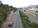
The Brooker Highway runs approximately 17 km north from the CBD, through the northern suburbs of Hobart
, and through the City of Glenorchy
, bypassing commercial and industrial centres along the original Main Road. It is a four lane (dual-carriageway) highway, and apart from the Domain Highway
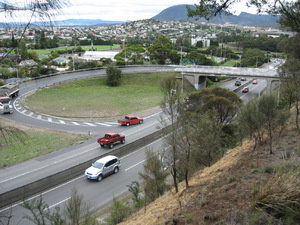
junction, only the northern sections of the highway have grade separated
junctions. The major at-grade
junctions are controlled by traffic light
and roundabout
intersections.
 The original Brooker Avenue was constructed in 1961 as a 2 lane road from the end of Liverpool Street to Elwick Road. In 1965, the Hobart Area Transportation Study
was released and entailed large development plans for the Brooker Highway. By 1968 the road had been duplicated and works reached Berriedale
. In 1977 the highway was further extended, taking the road to the Claremont
Link Road. By 1983 the highway that stands today was complete through to Granton and the Bridgewater bridge.
The Brooker Highway was built as a replacement to the original Midland Highway route between Hobart city and Granton
, which passed along Elizabeth Street
, New Town Road
and Main Road, through the built up areas of New Town
, Moonah
, Glenorchy
, Rosetta, Montrose, Claremont and Berriedale.
This was the first major highway construction in the Hobart City region, and was named the Brooker Highway, after the Minister for Transport at the time of the conception of the project, Edward Brooker
(between Davey Street and Cleary's Gates at the top of the ridge, the highway is also known as "Brooker Avenue").
 Eastern Outlet
(Tasman Highway), Davey Street
and Macquarie Street
. The Tasman Highway heads east over the Tasman Bridge
, past the Airport
and eventually leads to the east coast of the state, while Davey Street leads towards the Southern Outlet
, which in turn heads south towards Kingston
and Huonville
(Davey and Macquarie are one-way streets - Davey Street flows south-west, and Macquarie Street flows north-east through the CBD).
Apart from the connection to Davey and Macquarie Streets, the major intersection with streets in the CBD is the three-lane roundabout at the north-east end of Liverpool Street. Because it was built in close proximity to the main railway station at the time, the roundabout was, and continues to be, called the "Railway Roundabout". The sunken garden in the centre of the roundabout functions as a pedestrian thoroughfare, with under-road tunnels connecting to the two sides of Liverpool Street, the original site of the railway station to the north-east, and to the Domain and the suburb of The Glebe to the north-west. The roundabout was originally just an un-controlled intersection, but with the gradual increase in traffic, particularly from the eastern shore of the Derwent, it was often in grid-lock at peak travel times. Traffic lights were introduced and alleviated the situation, and later construction of the direct links from the Tasman Bridge to Davey and Macquarie Streets further relieved the pressure. Other streets from the CBD provide access to the highway, but for much of its length to the city boundary at Risdon Road it is limited access road.
Through the City of Glenorchy the highway has large multi-lane intersections, at Risdon Road, Elwick Road and Derwent Park Road. The highway is in a reasonable condition for its age, and experiences congestion for only a few hours a day.
Trees line the middle nature strip for several kilometres, and fencing prevents pedestrian access at various points.
The Highway makes its way past The Domain
, Cornelian Bay Hockey Grounds, Rugby Park, The Royal Hobart Showgrounds
, Tattersalls Park
and the Derwent Entertainment Centre
.
At the northern end (at Granton
) it connects to the Midland Highway (which heads north towards Launceston
) and the Lyell Highway
(which takes motorists towards the west coast
).
between Risdon Road and Clearys Gates Road. These are over 40 years old and were the first lights on the Highway, which sparked some concern from the Hobart City Council
. They argue that the light poles are in good condition and are a significant feature of the Brooker Highway entrance to Hobart. While the Hobart City Council supports the replacement, they have written to Infrastructure Minister Jim Cox asking him to consider retaining the ornate arms on modern pole bases.
The Department of Infrastructure, Energy and Resources
proposes to re-align the Elwick Road
and Goodwood Road
exits, reducing confusion and the number of traffic lights. The nearby Goodwood
roundabout will also be replaced with traffic lights. The Tasmanian Government has also revealed they are currently planning to upgrade the interchange at the Domain Highway
to improve access and travel flows for passenger and freight. This includes a capacity expansion to 6 lanes from the Domain Highway to Risdon Road.
Recently the government came under pressure from the community to improve pedestrian access over the highway at Goodwood
and eliminate the stairs primarily for the benefit of the elderly and handicapped.
Highway
A highway is any public road. In American English, the term is common and almost always designates major roads. In British English, the term designates any road open to the public. Any interconnected set of highways can be variously referred to as a "highway system", a "highway network", or a...
in the State of Tasmania
Tasmania
Tasmania is an Australian island and state. It is south of the continent, separated by Bass Strait. The state includes the island of Tasmania—the 26th largest island in the world—and the surrounding islands. The state has a population of 507,626 , of whom almost half reside in the greater Hobart...
, Australia
Australia
Australia , officially the Commonwealth of Australia, is a country in the Southern Hemisphere comprising the mainland of the Australian continent, the island of Tasmania, and numerous smaller islands in the Indian and Pacific Oceans. It is the world's sixth-largest country by total area...
. Also known as the Northern Outlet, the highway is the major arterial route
Trunk road
A trunk road, trunk highway, or strategic road is a major road—usually connecting two or more cities, ports, airports, and other things.—which is the recommended route for long-distance and freight traffic...
through Hobart's northern suburbs and is Hobart's major road connection to the cities and towns of Northern Tasmania. It is a part of the National Highway
National Highway (Australia)
thumb|right|150px|The National Highway Shield in NSW, QLD, WA, NT & TAS.The National Highway is a system of roads connecting all the States and Territories of Australia, and is the major network of highways connecting Australia's largest and most important cities.The National Highway was...
Network and is one of Tasmania's busiest highways.
The Brooker Highway runs approximately 17 km north from the CBD, through the northern suburbs of Hobart
Hobart
Hobart is the state capital and most populous city of the Australian island state of Tasmania. Founded in 1804 as a penal colony,Hobart is Australia's second oldest capital city after Sydney. In 2009, the city had a greater area population of approximately 212,019. A resident of Hobart is known as...
, and through the City of Glenorchy
Glenorchy, Tasmania
Glenorchy is a business district and suburb in the northern part of greater Hobart, capital of the state of Tasmania, Australia. The land was originally used for agriculture but is now a largely suburban, working-class area...
, bypassing commercial and industrial centres along the original Main Road. It is a four lane (dual-carriageway) highway, and apart from the Domain Highway
Domain Highway
The Domain Highway is a highway in Hobart, Tasmania. The Highway is a Link road bypassing Hobart, starting at the Brooker Highway and heading southeast between the banks of the Derwent River and the Hobart Domain and botanical gardens...
junction, only the northern sections of the highway have grade separated
Grade separation
Grade separation is the method of aligning a junction of two or more transport axes at different heights so that they will not disrupt the traffic flow on other transit routes when they cross each other. The composition of such transport axes does not have to be uniform; it can consist of a...
junctions. The major at-grade
At-grade intersection
An at-grade intersection is a junction at which two or more transport axes cross at the same level .-Traffic management:With areas of high or fast traffic, an at-grade intersection normally requires a traffic control device such as a stop sign, traffic light or railway signal to manage conflicting...
junctions are controlled by traffic light
Traffic light
Traffic lights, which may also be known as stoplights, traffic lamps, traffic signals, signal lights, robots or semaphore, are signalling devices positioned at road intersections, pedestrian crossings and other locations to control competing flows of traffic...
and roundabout
Roundabout
A roundabout is the name for a road junction in which traffic moves in one direction around a central island. The word dates from the early 20th century. Roundabouts are common in many countries around the world...
intersections.
History
Hobart Area Transportation Study
The Hobart Area Transportation Study was a comprehensive transport plan released in 1965 for the purpose of examining the transport needs of the Hobart Metropolitan area over the proceeding 20 years...
was released and entailed large development plans for the Brooker Highway. By 1968 the road had been duplicated and works reached Berriedale
Berriedale, Tasmania
Berriedale is a suburb in the northern suburbs of Hobart, capital of Tasmania, Australia. It is in the local government area of City of Glenorchy. The suburb is situated between the suburbs of Chigwell and Rosetta. There are no educational institutions within Berriedale, however there are primary...
. In 1977 the highway was further extended, taking the road to the Claremont
Claremont, Tasmania
Claremont is a suburb of the City of Glenorchy, part of the greater Hobart area, Tasmania, Australia. It is named after Claremont House, which was built in the 1830s by local settler Henry Bilton, who named it after one of the royal homes of England. Claremont was the home of an Army training...
Link Road. By 1983 the highway that stands today was complete through to Granton and the Bridgewater bridge.
The Brooker Highway was built as a replacement to the original Midland Highway route between Hobart city and Granton
Granton, Tasmania
Granton is a suburb of Hobart, capital city of Tasmania, Australia. It is the most northern suburb of the City of Glenorchy Local Government Area....
, which passed along Elizabeth Street
Elizabeth Street, Hobart
Elizabeth Street is a major street which runs North-South through the city and suburbs of Hobart, Tasmania, Australia. It is named after Elizabeth Macquarie, the wife of the Governor of New South Wales from 1810-1821, Lachlan Macquarie....
, New Town Road
New Town Road
New Town Road is a link road that connects Elizabeth Street to the Main Road within the greater area of Hobart, Tasmania. Prior to the construction of the Brooker Highway most traffic had to travel via this road to the main road to get to the north of the state....
and Main Road, through the built up areas of New Town
New Town, Tasmania
New Town is a suburb of the city of Hobart, Tasmania, Australia, located about 4 km north of the central business district of Hobart. One of the city's oldest suburbs, it is now an inner city residential suburb. Many of its streets are lined with Federation style cottages...
, Moonah
Moonah, Tasmania
Moonah is a central business district and a large suburb within the greater area of Hobart, Tasmania. Moonah lies in the Local government area of City of Glenorchy. It was originally land given free to settlers along the banks of the New Town Rivulet. These areas eventually became known as the...
, Glenorchy
Glenorchy, Tasmania
Glenorchy is a business district and suburb in the northern part of greater Hobart, capital of the state of Tasmania, Australia. The land was originally used for agriculture but is now a largely suburban, working-class area...
, Rosetta, Montrose, Claremont and Berriedale.
This was the first major highway construction in the Hobart City region, and was named the Brooker Highway, after the Minister for Transport at the time of the conception of the project, Edward Brooker
(between Davey Street and Cleary's Gates at the top of the ridge, the highway is also known as "Brooker Avenue").
Route description
The highway starts in the Hobart CBD at the junction withTasman Highway
The Tasman Highway is a highway in Tasmania, Australia. Like the Midland Highway, it connects the major cities of Hobart and Launceston — however it takes a different route, via the north-eastern and eastern coasts of the state. The Highway also acts as a major commuter road to Hobart...
(Tasman Highway),
Davey Street, Hobart
Davey Street is one of the main streets of the central business district of the city of Hobart, capital of Tasmania, Australia. As well as forming the southern border of the CBD, it is part of the A6, technically making it part of the Huon Highway....
and
Macquarie Street, Hobart
Macquarie Street is one of the main streets of the central business district of the city of Hobart, capital of Tasmania, Australia. It is part of the A6, technically making it part of the Huon Highway...
. The Tasman Highway heads east over the Tasman Bridge
Tasman Bridge
The Tasman Bridge is a five-lane bridge crossing the Derwent River, near the CBD of Hobart, Tasmania. The bridge has a total length of 1,395 metres . It provides the main traffic route from the CBD to the eastern shore - particularly Hobart International Airport and Bellerive Oval...
, past the Airport
Hobart International Airport
Hobart International Airport is an airport located in Cambridge, east of Hobart, Tasmania. The Federal government owned airport is currently being operated on a 99 year lease to the Tasmanian Gateway Consortium. The airport has seen strong passenger growth in the last few years, primarily due to...
and eventually leads to the east coast of the state, while Davey Street leads towards the
Southern Outlet, Hobart
The Southern Outlet is a 13km dual-carriageway limited-access highway that connects Hobart to the southern parts of Tasmania, Australia...
, which in turn heads south towards Kingston
Kingston, Tasmania
Kingston is a township and region on the outskirts of Hobart, Tasmania, Australia. Nestled 15 km south of the city between and around several hills, Kingston is the council seat of its wider municipality, the Kingborough Council, and today serves as the gateway between Hobart and the...
and Huonville
Huonville, Tasmania
Huonville is a town on the Huon River, in the south-east of Tasmania, Australia. The town lies within the Huon Valley Council area. It lies 38 km south of Hobart on the Huon Highway. At the 2006 census, Huonville had a population of 1,806....
(Davey and Macquarie are one-way streets - Davey Street flows south-west, and Macquarie Street flows north-east through the CBD).
Apart from the connection to Davey and Macquarie Streets, the major intersection with streets in the CBD is the three-lane roundabout at the north-east end of Liverpool Street. Because it was built in close proximity to the main railway station at the time, the roundabout was, and continues to be, called the "Railway Roundabout". The sunken garden in the centre of the roundabout functions as a pedestrian thoroughfare, with under-road tunnels connecting to the two sides of Liverpool Street, the original site of the railway station to the north-east, and to the Domain and the suburb of The Glebe to the north-west. The roundabout was originally just an un-controlled intersection, but with the gradual increase in traffic, particularly from the eastern shore of the Derwent, it was often in grid-lock at peak travel times. Traffic lights were introduced and alleviated the situation, and later construction of the direct links from the Tasman Bridge to Davey and Macquarie Streets further relieved the pressure. Other streets from the CBD provide access to the highway, but for much of its length to the city boundary at Risdon Road it is limited access road.
Through the City of Glenorchy the highway has large multi-lane intersections, at Risdon Road, Elwick Road and Derwent Park Road. The highway is in a reasonable condition for its age, and experiences congestion for only a few hours a day.
Trees line the middle nature strip for several kilometres, and fencing prevents pedestrian access at various points.
The Highway makes its way past The Domain
Queens Domain
The Queens Domain, also known as The Domain to locals, is a small hilly area of bushland just north-east of the CBD of Hobart, Tasmania, Australia, alongside the Derwent River...
, Cornelian Bay Hockey Grounds, Rugby Park, The Royal Hobart Showgrounds
Hobart Showground
The Royal Hobart Showgrounds is the site of the Royal Hobart Show and many other smaller events including a Market on the grounds every Sunday. The Royal Hobart Showground is located 10 km north of Hobart, between the junction to Brooker Highway/Goodwood Road and the Main Road in Glenorchy.-Royal...
, Tattersalls Park
Tattersalls Park
Tattersalls Park is a Thoroughbred horse-racing venue located on Goodwood Road within Glenorchy, Tasmania, Australia. It is located in close proximity to the Brooker Highway, the Hobart Showground, the Derwent Entertainment Centre and the Derwent River...
and the Derwent Entertainment Centre
Derwent Entertainment Centre
Derwent Entertainment Centre is a multi-purpose arena and is the primary venue, in Hobart, for large indoor functions/events. It was constructed in 1989 and is situated in between the waterfront of the River Derwent, the Brooker Highway and Tattersalls Park.Between 1989 and 1996, it was the home of...
.
At the northern end (at Granton
Granton, Tasmania
Granton is a suburb of Hobart, capital city of Tasmania, Australia. It is the most northern suburb of the City of Glenorchy Local Government Area....
) it connects to the
Launceston, Tasmania
Launceston is a city in the north of the state of Tasmania, Australia at the junction of the North Esk and South Esk rivers where they become the Tamar River. Launceston is the second largest city in Tasmania after the state capital Hobart...
) and the
Lyell Highway
The Lyell Highway is a highway in Tasmania, running from Hobart to Queenstown. The name is derived from Mount Lyell, the mountain peak where copper was found in the late 19th century, and the site of the Mount Lyell copper mine, and the sole reason for the existence of Queenstown...
(which takes motorists towards the west coast
West Coast, Tasmania
The West Coast of Tasmania is the part of the state that is strongly associated with wilderness, mining and tourism, rough country and isolation...
).
Recent history
In April 2007, the Department of Infrastructure, Energy and Resources announced plans to replace the sub-standard rusted light polesStreet light
A street light, lamppost, street lamp, light standard, or lamp standard is a raised source of light on the edge of a road or walkway, which is turned on or lit at a certain time every night. Modern lamps may also have light-sensitive photocells to turn them on at dusk, off at dawn, or activate...
between Risdon Road and Clearys Gates Road. These are over 40 years old and were the first lights on the Highway, which sparked some concern from the Hobart City Council
Hobart
Hobart is the state capital and most populous city of the Australian island state of Tasmania. Founded in 1804 as a penal colony,Hobart is Australia's second oldest capital city after Sydney. In 2009, the city had a greater area population of approximately 212,019. A resident of Hobart is known as...
. They argue that the light poles are in good condition and are a significant feature of the Brooker Highway entrance to Hobart. While the Hobart City Council supports the replacement, they have written to Infrastructure Minister Jim Cox asking him to consider retaining the ornate arms on modern pole bases.
The Department of Infrastructure, Energy and Resources
Department of Infrastructure, Energy and Resources
The Department of Infrastructure, Energy and Resources is the department of the Government of Tasmania responsible for management of the state's infrastructure. It reports to several ministers including Jim Cox and Michael Aird....
proposes to re-align the Elwick Road
Elwick Road
Elwick Road is a major arrterial road that runs through the northern suburbs of Hobart, Tasmania. The Road is the major link road between the Main Road and the Brooker Highway that connects to Glenorchy...
and Goodwood Road
Goodwood Road, Tasmania
Goodwood Road is a 4 lane link road that connects the City of Glenorchy to the City of Clarence in the greater area of Hobart, Tasmania. Using the Bowen Bridge the road travels over the Derwent River in semi-highway road layout...
exits, reducing confusion and the number of traffic lights. The nearby Goodwood
Goodwood, Tasmania
Goodwood is a suburb of Hobart, Tasmania, Australia. It is part of the City of Glenorchy.The small residential suburb starts just south-east of the Brooker Highway and Goodwood Road junction. It is best known for its annual Christmas light decorations. Most houses in Goodwood were built in the...
roundabout will also be replaced with traffic lights. The Tasmanian Government has also revealed they are currently planning to upgrade the interchange at the Domain Highway
Domain Highway
The Domain Highway is a highway in Hobart, Tasmania. The Highway is a Link road bypassing Hobart, starting at the Brooker Highway and heading southeast between the banks of the Derwent River and the Hobart Domain and botanical gardens...
to improve access and travel flows for passenger and freight. This includes a capacity expansion to 6 lanes from the Domain Highway to Risdon Road.
Recently the government came under pressure from the community to improve pedestrian access over the highway at Goodwood
Goodwood, Tasmania
Goodwood is a suburb of Hobart, Tasmania, Australia. It is part of the City of Glenorchy.The small residential suburb starts just south-east of the Brooker Highway and Goodwood Road junction. It is best known for its annual Christmas light decorations. Most houses in Goodwood were built in the...
and eliminate the stairs primarily for the benefit of the elderly and handicapped.
2010 Emergency Landing Incident
On 4 April 2010 18 year old pilot Patrick Humphries made world headlines by using the normally busy highway as an emergency landing strip after experiencing aircraft problems. Humpries was unhurt from the accident and no vehicles where involved in the incident.Exits
| Brooker Highway |
|||
| Southbound interchanges | Distance from Tasman Highway (km) |
Distance from Lyell Highway (km) |
Northbound interchanges |
| End Brooker Highway continues as Davey Street Davey Street, Hobart Davey Street is one of the main streets of the central business district of the city of Hobart, capital of Tasmania, Australia. As well as forming the southern border of the CBD, it is part of the A6, technically making it part of the Huon Highway.... to Hobart Hobart Hobart is the state capital and most populous city of the Australian island state of Tasmania. Founded in 1804 as a penal colony,Hobart is Australia's second oldest capital city after Sydney. In 2009, the city had a greater area population of approximately 212,019. A resident of Hobart is known as... |
0 | 18.5 | Start Brooker Highway from Macquarie Street Macquarie Street, Hobart Macquarie Street is one of the main streets of the central business district of the city of Hobart, capital of Tasmania, Australia. It is part of the A6, technically making it part of the Huon Highway... |
| Bellerive Bellerive, Tasmania Bellerive is a suburb of the City of Clarence, part of the greater Hobart area, Tasmania, Australia. It stretches from Kangaroo Bay where it borders Rosny Park, around the curved shoreline of Bellerive Esplanade to Kangaroo Bluff, then down to Bellerive Beach and east to Second Bluff, where... , Sorell Sorell, Tasmania Sorell is a town in Tasmania, Australia, north-east of Hobart. It is on the Tasman Highway which continues up the east coast of Tasmania. At the 2006 census, Sorell had a population of 1,546.... Tasman Highway Tasman Highway The Tasman Highway is a highway in Tasmania, Australia. Like the Midland Highway, it connects the major cities of Hobart and Launceston — however it takes a different route, via the north-eastern and eastern coasts of the state. The Highway also acts as a major commuter road to Hobart...  |
Bellerive Bellerive, Tasmania Bellerive is a suburb of the City of Clarence, part of the greater Hobart area, Tasmania, Australia. It stretches from Kangaroo Bay where it borders Rosny Park, around the curved shoreline of Bellerive Esplanade to Kangaroo Bluff, then down to Bellerive Beach and east to Second Bluff, where... , Sorell Sorell, Tasmania Sorell is a town in Tasmania, Australia, north-east of Hobart. It is on the Tasman Highway which continues up the east coast of Tasmania. At the 2006 census, Sorell had a population of 1,546.... Tasman Highway Tasman Highway The Tasman Highway is a highway in Tasmania, Australia. Like the Midland Highway, it connects the major cities of Hobart and Launceston — however it takes a different route, via the north-eastern and eastern coasts of the state. The Highway also acts as a major commuter road to Hobart... |
||
| No Access | 0.2-0.3 | 18.3-18.2 | Hobart Hobart Hobart is the state capital and most populous city of the Australian island state of Tasmania. Founded in 1804 as a penal colony,Hobart is Australia's second oldest capital city after Sydney. In 2009, the city had a greater area population of approximately 212,019. A resident of Hobart is known as... Collins Street, Sackville Street  |
| Hobart Hobart Hobart is the state capital and most populous city of the Australian island state of Tasmania. Founded in 1804 as a penal colony,Hobart is Australia's second oldest capital city after Sydney. In 2009, the city had a greater area population of approximately 212,019. A resident of Hobart is known as... Liverpool Street (west) (exit only) |
0.4 | 18.1 | Hobart Hobart Hobart is the state capital and most populous city of the Australian island state of Tasmania. Founded in 1804 as a penal colony,Hobart is Australia's second oldest capital city after Sydney. In 2009, the city had a greater area population of approximately 212,019. A resident of Hobart is known as... Liverpool Street (west) (exit only) |
| Bellerive Bellerive, Tasmania Bellerive is a suburb of the City of Clarence, part of the greater Hobart area, Tasmania, Australia. It stretches from Kangaroo Bay where it borders Rosny Park, around the curved shoreline of Bellerive Esplanade to Kangaroo Bluff, then down to Bellerive Beach and east to Second Bluff, where... Liverpool Street (east) |
Hobart Hobart Hobart is the state capital and most populous city of the Australian island state of Tasmania. Founded in 1804 as a penal colony,Hobart is Australia's second oldest capital city after Sydney. In 2009, the city had a greater area population of approximately 212,019. A resident of Hobart is known as... Bathurst Street (entry only) |
||
| Hobart Hobart Hobart is the state capital and most populous city of the Australian island state of Tasmania. Founded in 1804 as a penal colony,Hobart is Australia's second oldest capital city after Sydney. In 2009, the city had a greater area population of approximately 212,019. A resident of Hobart is known as... Bathurst Street (entry only) |
Bellerive Bellerive, Tasmania Bellerive is a suburb of the City of Clarence, part of the greater Hobart area, Tasmania, Australia. It stretches from Kangaroo Bay where it borders Rosny Park, around the curved shoreline of Bellerive Esplanade to Kangaroo Bluff, then down to Bellerive Beach and east to Second Bluff, where... Liverpool Street (east) |
||
| Glebe Glebe, Tasmania Glebe is a suburb of Hobart, capital city of Tasmania, Australia. The suburb is a very small area adjacent to the city on the same part of land as the Queens Domain, the Royal Tasmanian Botanical Gardens and the Hobart Aquatic Center.... Edward Street |
0.6 | 17.9 | No Access |
| Hobart Hobart Hobart is the state capital and most populous city of the Australian island state of Tasmania. Founded in 1804 as a penal colony,Hobart is Australia's second oldest capital city after Sydney. In 2009, the city had a greater area population of approximately 212,019. A resident of Hobart is known as... Brisbane Street (exit only) |
0.7 | 17.8 | Hobart Hobart Hobart is the state capital and most populous city of the Australian island state of Tasmania. Founded in 1804 as a penal colony,Hobart is Australia's second oldest capital city after Sydney. In 2009, the city had a greater area population of approximately 212,019. A resident of Hobart is known as... Brisbane Street |
| Glebe Glebe, Tasmania Glebe is a suburb of Hobart, capital city of Tasmania, Australia. The suburb is a very small area adjacent to the city on the same part of land as the Queens Domain, the Royal Tasmanian Botanical Gardens and the Hobart Aquatic Center.... Scott Street, Lillie Street, Davenport Street |
0.8-1.0 | 17.7-17.5 | No Access |
| North Hobart North Hobart, Tasmania North Hobart is a suburb of the city of Hobart, Tasmania, Australia. As its name suggests, it lies directly north of the CBD.The main street of North Hobart is Elizabeth Street, which extends northward from the Elizabeth Street Mall in the city, through North Hobart, and then becomes the Main Road... Warwick Street |
1.1 | 17.4 | North Hobart North Hobart, Tasmania North Hobart is a suburb of the city of Hobart, Tasmania, Australia. As its name suggests, it lies directly north of the CBD.The main street of North Hobart is Elizabeth Street, which extends northward from the Elizabeth Street Mall in the city, through North Hobart, and then becomes the Main Road... Warwick Street |
| Glebe Glebe, Tasmania Glebe is a suburb of Hobart, capital city of Tasmania, Australia. The suburb is a very small area adjacent to the city on the same part of land as the Queens Domain, the Royal Tasmanian Botanical Gardens and the Hobart Aquatic Center.... Shoobridge Street |
1.3 | 17.2 | North Hobart North Hobart, Tasmania North Hobart is a suburb of the city of Hobart, Tasmania, Australia. As its name suggests, it lies directly north of the CBD.The main street of North Hobart is Elizabeth Street, which extends northward from the Elizabeth Street Mall in the city, through North Hobart, and then becomes the Main Road... Burnett Street |
| North Hobart North Hobart, Tasmania North Hobart is a suburb of the city of Hobart, Tasmania, Australia. As its name suggests, it lies directly north of the CBD.The main street of North Hobart is Elizabeth Street, which extends northward from the Elizabeth Street Mall in the city, through North Hobart, and then becomes the Main Road... Burnett Street |
|||
| No Access | 1.7 | 16.8 | North Hobart North Hobart, Tasmania North Hobart is a suburb of the city of Hobart, Tasmania, Australia. As its name suggests, it lies directly north of the CBD.The main street of North Hobart is Elizabeth Street, which extends northward from the Elizabeth Street Mall in the city, through North Hobart, and then becomes the Main Road... Federal Street |
| Queens Domain Clearys Gates Road |
2.4 | 16.1 | No Access |
| New Town New Town, Tasmania New Town is a suburb of the city of Hobart, Tasmania, Australia, located about 4 km north of the central business district of Hobart. One of the city's oldest suburbs, it is now an inner city residential suburb. Many of its streets are lined with Federation style cottages... Park Street (exit only) |
2.6 | 15.9 | New Town New Town, Tasmania New Town is a suburb of the city of Hobart, Tasmania, Australia, located about 4 km north of the central business district of Hobart. One of the city's oldest suburbs, it is now an inner city residential suburb. Many of its streets are lined with Federation style cottages... Park Street |
| Bellerive Bellerive, Tasmania Bellerive is a suburb of the City of Clarence, part of the greater Hobart area, Tasmania, Australia. It stretches from Kangaroo Bay where it borders Rosny Park, around the curved shoreline of Bellerive Esplanade to Kangaroo Bluff, then down to Bellerive Beach and east to Second Bluff, where... , Hobart Hobart Hobart is the state capital and most populous city of the Australian island state of Tasmania. Founded in 1804 as a penal colony,Hobart is Australia's second oldest capital city after Sydney. In 2009, the city had a greater area population of approximately 212,019. A resident of Hobart is known as... Domain Highway Domain Highway The Domain Highway is a highway in Hobart, Tasmania. The Highway is a Link road bypassing Hobart, starting at the Brooker Highway and heading southeast between the banks of the Derwent River and the Hobart Domain and botanical gardens... |
3.2 | 15.3 | Bellerive Bellerive, Tasmania Bellerive is a suburb of the City of Clarence, part of the greater Hobart area, Tasmania, Australia. It stretches from Kangaroo Bay where it borders Rosny Park, around the curved shoreline of Bellerive Esplanade to Kangaroo Bluff, then down to Bellerive Beach and east to Second Bluff, where... , Hobart Hobart Hobart is the state capital and most populous city of the Australian island state of Tasmania. Founded in 1804 as a penal colony,Hobart is Australia's second oldest capital city after Sydney. In 2009, the city had a greater area population of approximately 212,019. A resident of Hobart is known as... Domain Highway Domain Highway The Domain Highway is a highway in Hobart, Tasmania. The Highway is a Link road bypassing Hobart, starting at the Brooker Highway and heading southeast between the banks of the Derwent River and the Hobart Domain and botanical gardens... |
| New Town New Town, Tasmania New Town is a suburb of the city of Hobart, Tasmania, Australia, located about 4 km north of the central business district of Hobart. One of the city's oldest suburbs, it is now an inner city residential suburb. Many of its streets are lined with Federation style cottages... Risdon Road |
4.1 | 14.4 | New Town New Town, Tasmania New Town is a suburb of the city of Hobart, Tasmania, Australia, located about 4 km north of the central business district of Hobart. One of the city's oldest suburbs, it is now an inner city residential suburb. Many of its streets are lined with Federation style cottages... Risdon Road |
| Moonah Moonah, Tasmania Moonah is a central business district and a large suburb within the greater area of Hobart, Tasmania. Moonah lies in the Local government area of City of Glenorchy. It was originally land given free to settlers along the banks of the New Town Rivulet. These areas eventually became known as the... Bowen Road |
4.9 | 13.6 | Moonah Moonah, Tasmania Moonah is a central business district and a large suburb within the greater area of Hobart, Tasmania. Moonah lies in the Local government area of City of Glenorchy. It was originally land given free to settlers along the banks of the New Town Rivulet. These areas eventually became known as the... Bowen Road |
| Lutana Lutana, Tasmania Lutana is a suburb of Hobart, Tasmania, Australia. It is part of the City of Glenorchy.It is a large residential suburb located between the Brooker Highway and Derwent River. It was originally built by the Electrolytic Zinc company as homes for its employees at the nearby zinc smelter. The... Ashbolt Crescent |
Lutana Lutana, Tasmania Lutana is a suburb of Hobart, Tasmania, Australia. It is part of the City of Glenorchy.It is a large residential suburb located between the Brooker Highway and Derwent River. It was originally built by the Electrolytic Zinc company as homes for its employees at the nearby zinc smelter. The... Ashbolt Crescent |
||
| Lutana Lutana, Tasmania Lutana is a suburb of Hobart, Tasmania, Australia. It is part of the City of Glenorchy.It is a large residential suburb located between the Brooker Highway and Derwent River. It was originally built by the Electrolytic Zinc company as homes for its employees at the nearby zinc smelter. The... Bowen Road |
5 | 13.5 | No Access |
| Derwent Park Derwent Park, Tasmania Derwent Park is a suburb of Hobart, Tasmania, Australia. It is part of the City of Glenorchy.It is predominantly a light commercial and industrial area.... , Lutana Lutana, Tasmania Lutana is a suburb of Hobart, Tasmania, Australia. It is part of the City of Glenorchy.It is a large residential suburb located between the Brooker Highway and Derwent River. It was originally built by the Electrolytic Zinc company as homes for its employees at the nearby zinc smelter. The... Derwent Park Road Derwent Park Road Derwent Park Road is a major link road that connects the Brooker Highway to the Main Road, in the northern suburbs of Hobart, Tasmania. The Road starts at Main Road, Derwent Park and continues East across the Brooker Highway, ending at the Hobart Zinc Works. The road serves in excess of 14,000... |
5.6 | 12.9 | Derwent Park Derwent Park, Tasmania Derwent Park is a suburb of Hobart, Tasmania, Australia. It is part of the City of Glenorchy.It is predominantly a light commercial and industrial area.... , Lutana Lutana, Tasmania Lutana is a suburb of Hobart, Tasmania, Australia. It is part of the City of Glenorchy.It is a large residential suburb located between the Brooker Highway and Derwent River. It was originally built by the Electrolytic Zinc company as homes for its employees at the nearby zinc smelter. The... Derwent Park Road Derwent Park Road Derwent Park Road is a major link road that connects the Brooker Highway to the Main Road, in the northern suburbs of Hobart, Tasmania. The Road starts at Main Road, Derwent Park and continues East across the Brooker Highway, ending at the Hobart Zinc Works. The road serves in excess of 14,000... |
| Goodwood Goodwood, Tasmania Goodwood is a suburb of Hobart, Tasmania, Australia. It is part of the City of Glenorchy.The small residential suburb starts just south-east of the Brooker Highway and Goodwood Road junction. It is best known for its annual Christmas light decorations. Most houses in Goodwood were built in the... Lampton Avenue Lampton Avenue, Hobart Lampton Avenue is a major link road that connects the Brooker Highway to the Main Road, in the northern suburbs of Hobart, Tasmania. The Road Starts at Goodwood, Tasmania and continues through the traffic lights intersection on the Brooker Highway... (east) |
6.3 | 12.2 | Derwent Park Derwent Park, Tasmania Derwent Park is a suburb of Hobart, Tasmania, Australia. It is part of the City of Glenorchy.It is predominantly a light commercial and industrial area.... Lampton Avenue Lampton Avenue, Hobart Lampton Avenue is a major link road that connects the Brooker Highway to the Main Road, in the northern suburbs of Hobart, Tasmania. The Road Starts at Goodwood, Tasmania and continues through the traffic lights intersection on the Brooker Highway... (west) |
| Derwent Park Derwent Park, Tasmania Derwent Park is a suburb of Hobart, Tasmania, Australia. It is part of the City of Glenorchy.It is predominantly a light commercial and industrial area.... Lampton Avenue Lampton Avenue, Hobart Lampton Avenue is a major link road that connects the Brooker Highway to the Main Road, in the northern suburbs of Hobart, Tasmania. The Road Starts at Goodwood, Tasmania and continues through the traffic lights intersection on the Brooker Highway... (west) |
|||
| Derwent Park Derwent Park, Tasmania Derwent Park is a suburb of Hobart, Tasmania, Australia. It is part of the City of Glenorchy.It is predominantly a light commercial and industrial area.... Howard Road .svg.png) |
7.1 | 11.4 | Derwent Park Derwent Park, Tasmania Derwent Park is a suburb of Hobart, Tasmania, Australia. It is part of the City of Glenorchy.It is predominantly a light commercial and industrial area.... Howard Road |
| Goodwood Goodwood, Tasmania Goodwood is a suburb of Hobart, Tasmania, Australia. It is part of the City of Glenorchy.The small residential suburb starts just south-east of the Brooker Highway and Goodwood Road junction. It is best known for its annual Christmas light decorations. Most houses in Goodwood were built in the... Renfrew Court |
Goodwood Goodwood, Tasmania Goodwood is a suburb of Hobart, Tasmania, Australia. It is part of the City of Glenorchy.The small residential suburb starts just south-east of the Brooker Highway and Goodwood Road junction. It is best known for its annual Christmas light decorations. Most houses in Goodwood were built in the... Renfrew Court |
||
| Dowsing Point Dowsing Point, Tasmania Dowsing Point is a locality of the greater area of Hobart, Tasmania, Australia. It is part of the City of Glenorchy and encompasses the area of land North-East of Goodwood protruding into the Derwent River... , Bowen Bridge Bowen Bridge The Bowen Bridge is a four-lane road bridge crossing the Derwent River in Tasmania, Australia. The Bridge lies on the river approximately half way between the Tasman Bridge and the Bridgewater Bridge. The Bridge links the East Derwent Highway with the Brooker Highway at Glenorchy some 10... Goodwood Road Goodwood Road, Tasmania Goodwood Road is a 4 lane link road that connects the City of Glenorchy to the City of Clarence in the greater area of Hobart, Tasmania. Using the Bowen Bridge the road travels over the Derwent River in semi-highway road layout...  |
7.5 | 11 | Dowsing Point Dowsing Point, Tasmania Dowsing Point is a locality of the greater area of Hobart, Tasmania, Australia. It is part of the City of Glenorchy and encompasses the area of land North-East of Goodwood protruding into the Derwent River... , Bowen Bridge Bowen Bridge The Bowen Bridge is a four-lane road bridge crossing the Derwent River in Tasmania, Australia. The Bridge lies on the river approximately half way between the Tasman Bridge and the Bridgewater Bridge. The Bridge links the East Derwent Highway with the Brooker Highway at Glenorchy some 10... Goodwood Road Goodwood Road, Tasmania Goodwood Road is a 4 lane link road that connects the City of Glenorchy to the City of Clarence in the greater area of Hobart, Tasmania. Using the Bowen Bridge the road travels over the Derwent River in semi-highway road layout... |
| Glenorchy Glenorchy, Tasmania Glenorchy is a business district and suburb in the northern part of greater Hobart, capital of the state of Tasmania, Australia. The land was originally used for agriculture but is now a largely suburban, working-class area... Elwick Road Elwick Road Elwick Road is a major arrterial road that runs through the northern suburbs of Hobart, Tasmania. The Road is the major link road between the Main Road and the Brooker Highway that connects to Glenorchy... |
7.6 | 10.9 | Glenorchy Glenorchy, Tasmania Glenorchy is a business district and suburb in the northern part of greater Hobart, capital of the state of Tasmania, Australia. The land was originally used for agriculture but is now a largely suburban, working-class area... Elwick Road Elwick Road Elwick Road is a major arrterial road that runs through the northern suburbs of Hobart, Tasmania. The Road is the major link road between the Main Road and the Brooker Highway that connects to Glenorchy... |
| Derwent Entertainment Centre Derwent Entertainment Centre Derwent Entertainment Centre is a multi-purpose arena and is the primary venue, in Hobart, for large indoor functions/events. It was constructed in 1989 and is situated in between the waterfront of the River Derwent, the Brooker Highway and Tattersalls Park.Between 1989 and 1996, it was the home of... Loyd Road |
8 | 10.5 | Derwent Entertainment Centre Derwent Entertainment Centre Derwent Entertainment Centre is a multi-purpose arena and is the primary venue, in Hobart, for large indoor functions/events. It was constructed in 1989 and is situated in between the waterfront of the River Derwent, the Brooker Highway and Tattersalls Park.Between 1989 and 1996, it was the home of... Loyd Road |
| Montrose Montrose, Tasmania Montrose, is a suburb in the northern suburbs of Hobart, capital of Tasmania, Australia. The suburb is situated in close promity with Rosetta. Montrose is the suburb directly north of Glenorchy and lies within the local government area of City of Glenorchy... Duncan Street .svg.png) |
9.1 | 9.4 | Montrose Montrose, Tasmania Montrose, is a suburb in the northern suburbs of Hobart, capital of Tasmania, Australia. The suburb is situated in close promity with Rosetta. Montrose is the suburb directly north of Glenorchy and lies within the local government area of City of Glenorchy... Duncan Street |
| Foreshore Road (No Through Road Cul-de-sac A cul-de-sac is a word of French origin referring to a dead end, close, no through road or court meaning dead-end street with only one inlet/outlet... ) |
Foreshore Road (No Through Road Cul-de-sac A cul-de-sac is a word of French origin referring to a dead end, close, no through road or court meaning dead-end street with only one inlet/outlet... ) |
||
| Dodson Street (No Through Road Cul-de-sac A cul-de-sac is a word of French origin referring to a dead end, close, no through road or court meaning dead-end street with only one inlet/outlet... ) |
9.6 | 8.9 | Dodson Street (No Through Road Cul-de-sac A cul-de-sac is a word of French origin referring to a dead end, close, no through road or court meaning dead-end street with only one inlet/outlet... ) |
| Berriedale Berriedale, Tasmania Berriedale is a suburb in the northern suburbs of Hobart, capital of Tasmania, Australia. It is in the local government area of City of Glenorchy. The suburb is situated between the suburbs of Chigwell and Rosetta. There are no educational institutions within Berriedale, however there are primary... , Rosetta Rosetta, Tasmania Rosetta is a suburb in the northern suburbs of Hobart, capital of the Australian state of Tasmania. It is in the local government area of City of Glenorchy. The suburb is situated between the suburbs of Berriedale and Montrose and is approximately 15 minutes drive from Hobart. There is a primary... Main Road |
10 | 8.5 | Berriedale Berriedale, Tasmania Berriedale is a suburb in the northern suburbs of Hobart, capital of Tasmania, Australia. It is in the local government area of City of Glenorchy. The suburb is situated between the suburbs of Chigwell and Rosetta. There are no educational institutions within Berriedale, however there are primary... , Rosetta Rosetta, Tasmania Rosetta is a suburb in the northern suburbs of Hobart, capital of the Australian state of Tasmania. It is in the local government area of City of Glenorchy. The suburb is situated between the suburbs of Berriedale and Montrose and is approximately 15 minutes drive from Hobart. There is a primary... Main Road |
| Berriedale Berriedale, Tasmania Berriedale is a suburb in the northern suburbs of Hobart, capital of Tasmania, Australia. It is in the local government area of City of Glenorchy. The suburb is situated between the suburbs of Chigwell and Rosetta. There are no educational institutions within Berriedale, however there are primary... , Collinsvale Collinsvale, Tasmania Collinsvale is a suburb of the City of Glenorchy, part of the greater Hobart area in Tasmania, Australia.The area was originally known called Sorell Creek, and was inhabited mostly by British settlers in the mid-nineteenth century... Berriedale Road  |
10.6 | 7.9 | Berriedale Berriedale, Tasmania Berriedale is a suburb in the northern suburbs of Hobart, capital of Tasmania, Australia. It is in the local government area of City of Glenorchy. The suburb is situated between the suburbs of Chigwell and Rosetta. There are no educational institutions within Berriedale, however there are primary... , Collinsvale Collinsvale, Tasmania Collinsvale is a suburb of the City of Glenorchy, part of the greater Hobart area in Tasmania, Australia.The area was originally known called Sorell Creek, and was inhabited mostly by British settlers in the mid-nineteenth century... Berriedale Road |
| Chigwell Chigwell, Tasmania Chigwell is a suburb in the 'northern suburbs' area of Hobart, the capital city of Tasmania, Australia. The suburb is situated between the suburbs of Berriedale, Claremont and Glenlusk. The suburb shares its border with Berriedale along the Brooker Highway and the streets north of Berriedale Rd... , Claremont Claremont, Tasmania Claremont is a suburb of the City of Glenorchy, part of the greater Hobart area, Tasmania, Australia. It is named after Claremont House, which was built in the 1830s by local settler Henry Bilton, who named it after one of the royal homes of England. Claremont was the home of an Army training... Claremont Link Road |
12.4 | 6.1 | Chigwell Chigwell, Tasmania Chigwell is a suburb in the 'northern suburbs' area of Hobart, the capital city of Tasmania, Australia. The suburb is situated between the suburbs of Berriedale, Claremont and Glenlusk. The suburb shares its border with Berriedale along the Brooker Highway and the streets north of Berriedale Rd... , Claremont Claremont, Tasmania Claremont is a suburb of the City of Glenorchy, part of the greater Hobart area, Tasmania, Australia. It is named after Claremont House, which was built in the 1830s by local settler Henry Bilton, who named it after one of the royal homes of England. Claremont was the home of an Army training... Claremont Link Road |
| Claremont Claremont, Tasmania Claremont is a suburb of the City of Glenorchy, part of the greater Hobart area, Tasmania, Australia. It is named after Claremont House, which was built in the 1830s by local settler Henry Bilton, who named it after one of the royal homes of England. Claremont was the home of an Army training... Abbotsfield Road |
13.7 | 4.8 | Claremont Claremont, Tasmania Claremont is a suburb of the City of Glenorchy, part of the greater Hobart area, Tasmania, Australia. It is named after Claremont House, which was built in the 1830s by local settler Henry Bilton, who named it after one of the royal homes of England. Claremont was the home of an Army training... Abbotsfield Road |
| Claremont Claremont, Tasmania Claremont is a suburb of the City of Glenorchy, part of the greater Hobart area, Tasmania, Australia. It is named after Claremont House, which was built in the 1830s by local settler Henry Bilton, who named it after one of the royal homes of England. Claremont was the home of an Army training... Hilton Road |
15 | 3.5 | Claremont Claremont, Tasmania Claremont is a suburb of the City of Glenorchy, part of the greater Hobart area, Tasmania, Australia. It is named after Claremont House, which was built in the 1830s by local settler Henry Bilton, who named it after one of the royal homes of England. Claremont was the home of an Army training... Upper Hilton Road |
| Start Dual Carriageway Dual carriageway A dual carriageway is a class of highway with two carriageways for traffic travelling in opposite directions separated by a central reservation... |
17.2 | 1.3 | End Dual Carriageway Dual carriageway A dual carriageway is a class of highway with two carriageways for traffic travelling in opposite directions separated by a central reservation... |
| Granton Granton, Tasmania Granton is a suburb of Hobart, capital city of Tasmania, Australia. It is the most northern suburb of the City of Glenorchy Local Government Area.... Black Snake Road (On ramp only) |
17.9 | 0.6 | Granton Granton, Tasmania Granton is a suburb of Hobart, capital city of Tasmania, Australia. It is the most northern suburb of the City of Glenorchy Local Government Area.... Black Snake Road |
| Granton Granton, Tasmania Granton is a suburb of Hobart, capital city of Tasmania, Australia. It is the most northern suburb of the City of Glenorchy Local Government Area.... Main Road (Off ramp only) |
18.3 | 0.2 | No Access |
| New Norfolk New Norfolk, Tasmania -References:5. Fellowship of First Fleeters.6. New Norfolk's History and Achievements by Joe Cowburn and Rita Cox 1986-External links:* has extensive local information, history, photographs, resources and attractions... , Queenstown Queenstown, Tasmania Queenstown is a town in the West Coast region of the island of Tasmania. It is located in a valley on western slopes of Mount Owen on the West Coast Range.It had a population of 5,119 people . At the 2006 census, Queenstown had a population of 2,117.... Lyell Highway Lyell Highway The Lyell Highway is a highway in Tasmania, running from Hobart to Queenstown. The name is derived from Mount Lyell, the mountain peak where copper was found in the late 19th century, and the site of the Mount Lyell copper mine, and the sole reason for the existence of Queenstown... |
18.5 | 0 | New Norfolk New Norfolk, Tasmania -References:5. Fellowship of First Fleeters.6. New Norfolk's History and Achievements by Joe Cowburn and Rita Cox 1986-External links:* has extensive local information, history, photographs, resources and attractions... , Queenstown Queenstown, Tasmania Queenstown is a town in the West Coast region of the island of Tasmania. It is located in a valley on western slopes of Mount Owen on the West Coast Range.It had a population of 5,119 people . At the 2006 census, Queenstown had a population of 2,117.... Lyell Highway Lyell Highway The Lyell Highway is a highway in Tasmania, running from Hobart to Queenstown. The name is derived from Mount Lyell, the mountain peak where copper was found in the late 19th century, and the site of the Mount Lyell copper mine, and the sole reason for the existence of Queenstown... |
| Start Brooker Highway continues from Midland Highway |
End Brooker Highway continues as Midland Highway to Bridgewater Bridgewater, Tasmania Bridgewater, Tasmania, is one greater Hobart's northern-most suburbs, located 19 km from the city. It is situated on the eastern shore of the Derwent River. It is a suburb of the local government area of the Municipality of Brighton.... , Launceston Launceston, Tasmania Launceston is a city in the north of the state of Tasmania, Australia at the junction of the North Esk and South Esk rivers where they become the Tamar River. Launceston is the second largest city in Tasmania after the state capital Hobart... |
||