
Tasman Highway
Encyclopedia
The Tasman Highway is a highway
in Tasmania
, Australia
. Like the Midland Highway, it connects the major cities of Hobart
and Launceston
— however it takes a different route, via the north-eastern and eastern coasts of the state. The Highway also acts as a major commuter road to Hobart residents living on the eastern side of the Derwent River
. The designation "Tasman Highway" arises from its location facing the Tasman Sea
— named, like the state itself, after Abel Tasman
. The highway is one of the longest in Tasmania - 410 kilometres, with an average traveling time of 4 hours.
for Tasman Bridge
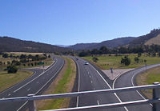
rush hour traffic). From the bridge to the airport
roundabout
, the highway is a four lane grade separated
limited-access road
. Both the South Arm Highway
and the East Derwent Highway
join up to the highway during this section of the highway.
Until the 1980s the only route to the airport was via Rosny Hill Road, Cambridge Road and Kennedy Drive. During 1990s, the section of highway between the Tasman Bridge
and the airport
was Primarily 2 lanes with constant overtaking lanes, however the Federal Government
funded the project to see the four lane expressway
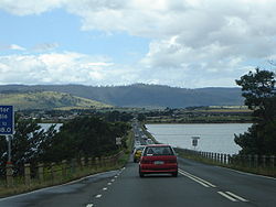
that exists today. For the remaining 4 km from the Airport the highway is 2 lanes, and travels over Mcgees Bridge
and the Sorell Causeway
on its way to Sorell
.
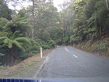
remains at the national standard as a two-lane highway, albeit with only a few overtaking lanes along its distance. The remainder of the road to St Helens
is two lane, with even fewer overtaking opportunities.
The eastern, coastal portion of the highway is spectacular, in places running just metres from the Tasman Sea
, which makes this the eastern-most A road in Tasmania.
The Tasman Highway is marketed as "East Coast Escape" between St Helens and Orford, to fit in with Tasmania's scheme of introducing tourist trails, a way of simplifying navigation of key tourist locations in Tasmania.
Prior to 1990, there was no coastal route between Falmouth and the Chain of Lagoons – one had to travel into and out of St Marys
, both roads being steep grades. The bypass was officially opened on 2 December 1991, though motorists had been using the partially constructed road before its opening. Great care was taken during the construction to protect Aboriginal
midden
s and the general environment.
At the Launceston
end, the highway is a main road with traffic lights. Out of the city, it becomes an ordinary two-lane road through the mountains. It passes waterfalls and through timber and rainforest country.
The portion between Launceston and Scottsdale runs through the Sideling Range. There is a lookout which offers a spectacular view of Scottsdale and its surrounds.
The highway also passes through several former mining towns.
Highway
A highway is any public road. In American English, the term is common and almost always designates major roads. In British English, the term designates any road open to the public. Any interconnected set of highways can be variously referred to as a "highway system", a "highway network", or a...
in Tasmania
Tasmania
Tasmania is an Australian island and state. It is south of the continent, separated by Bass Strait. The state includes the island of Tasmania—the 26th largest island in the world—and the surrounding islands. The state has a population of 507,626 , of whom almost half reside in the greater Hobart...
, Australia
Australia
Australia , officially the Commonwealth of Australia, is a country in the Southern Hemisphere comprising the mainland of the Australian continent, the island of Tasmania, and numerous smaller islands in the Indian and Pacific Oceans. It is the world's sixth-largest country by total area...
. Like the Midland Highway, it connects the major cities of Hobart
Hobart
Hobart is the state capital and most populous city of the Australian island state of Tasmania. Founded in 1804 as a penal colony,Hobart is Australia's second oldest capital city after Sydney. In 2009, the city had a greater area population of approximately 212,019. A resident of Hobart is known as...
and Launceston
Launceston, Tasmania
Launceston is a city in the north of the state of Tasmania, Australia at the junction of the North Esk and South Esk rivers where they become the Tamar River. Launceston is the second largest city in Tasmania after the state capital Hobart...
— however it takes a different route, via the north-eastern and eastern coasts of the state. The Highway also acts as a major commuter road to Hobart residents living on the eastern side of the Derwent River
Derwent River (Tasmania)
The Derwent is a river in Tasmania, Australia. It was named after the River Derwent, Cumbria by British Commodore John Hayes who explored it in 1793. The name is Brythonic Celtic for "valley thick with oaks"....
. The designation "Tasman Highway" arises from its location facing the Tasman Sea
Tasman Sea
The Tasman Sea is the large body of water between Australia and New Zealand, approximately across. It extends 2,800 km from north to south. It is a south-western segment of the South Pacific Ocean. The sea was named after the Dutch explorer Abel Janszoon Tasman, the first recorded European...
— named, like the state itself, after Abel Tasman
Abel Tasman
Abel Janszoon Tasman was a Dutch seafarer, explorer, and merchant, best known for his voyages of 1642 and 1644 in the service of the VOC . His was the first known European expedition to reach the islands of Van Diemen's Land and New Zealand and to sight the Fiji islands...
. The highway is one of the longest in Tasmania - 410 kilometres, with an average traveling time of 4 hours.
Eastern Outlet
The Tasman Highway starts at Hobart and is also known to some commuters as the Eastern Outlet. The highway starts as a four lane highway (with a special lane management systemReversible lane
A reversible lane , called a counterflow lane or contraflow lane in transport engineering nomenclature, is a lane in which traffic may travel in either direction, depending on certain conditions...
for Tasman Bridge
Tasman Bridge
The Tasman Bridge is a five-lane bridge crossing the Derwent River, near the CBD of Hobart, Tasmania. The bridge has a total length of 1,395 metres . It provides the main traffic route from the CBD to the eastern shore - particularly Hobart International Airport and Bellerive Oval...
rush hour traffic). From the bridge to the airport
Hobart International Airport
Hobart International Airport is an airport located in Cambridge, east of Hobart, Tasmania. The Federal government owned airport is currently being operated on a 99 year lease to the Tasmanian Gateway Consortium. The airport has seen strong passenger growth in the last few years, primarily due to...
roundabout
Roundabout
A roundabout is the name for a road junction in which traffic moves in one direction around a central island. The word dates from the early 20th century. Roundabouts are common in many countries around the world...
, the highway is a four lane grade separated
Grade separation
Grade separation is the method of aligning a junction of two or more transport axes at different heights so that they will not disrupt the traffic flow on other transit routes when they cross each other. The composition of such transport axes does not have to be uniform; it can consist of a...
limited-access road
Limited-access road
A limited-access road known by various terms worldwide, including limited-access highway, dual-carriageway and expressway, is a highway or arterial road for high-speed traffic which has many or most characteristics of a controlled-access highway , including limited or no access to adjacent...
. Both the South Arm Highway
South Arm Highway
The South Arm Highway is a highway in Hobart, Australia. The highway is a major Trunk road that carries heavy commuter traffic much like the Southern Outlet, except on the Eastern side of the Derwent River...
and the East Derwent Highway
East Derwent Highway
The East Derwent Highway is a highway in Hobart, Australia. The highway is a Trunk road that carries heavy commuter traffic much like the Brooker Highway, except on the Eastern side of the Derwent River...
join up to the highway during this section of the highway.
Until the 1980s the only route to the airport was via Rosny Hill Road, Cambridge Road and Kennedy Drive. During 1990s, the section of highway between the Tasman Bridge
Tasman Bridge
The Tasman Bridge is a five-lane bridge crossing the Derwent River, near the CBD of Hobart, Tasmania. The bridge has a total length of 1,395 metres . It provides the main traffic route from the CBD to the eastern shore - particularly Hobart International Airport and Bellerive Oval...
and the airport
Hobart International Airport
Hobart International Airport is an airport located in Cambridge, east of Hobart, Tasmania. The Federal government owned airport is currently being operated on a 99 year lease to the Tasmanian Gateway Consortium. The airport has seen strong passenger growth in the last few years, primarily due to...
was Primarily 2 lanes with constant overtaking lanes, however the Federal Government
Government of Australia
The Commonwealth of Australia is a federal constitutional monarchy under a parliamentary democracy. The Commonwealth of Australia was formed in 1901 as a result of an agreement among six self-governing British colonies, which became the six states...
funded the project to see the four lane expressway
Limited-access road
A limited-access road known by various terms worldwide, including limited-access highway, dual-carriageway and expressway, is a highway or arterial road for high-speed traffic which has many or most characteristics of a controlled-access highway , including limited or no access to adjacent...
that exists today. For the remaining 4 km from the Airport the highway is 2 lanes, and travels over Mcgees Bridge
Mcgees Bridge
Mcgees Bridge and causeway crosses Pitt Water within the greater area of Hobart, Tasmania.The bridge provides a vital link between Hobart and two of Tasmania's principal tourist attractions - Port Arthur Historic Site on the Tasman Peninsula and the picturesque East Coast via the Tasman...
and the Sorell Causeway
Sorell Causeway
The Sorell Causeway is a causeway that stretches from the western side of Midway Point across Orielton Lagoon to Sorell. Together with Mcgees Bridge they connect Sorell with Hobart via the Tasman Highway....
on its way to Sorell
Sorell, Tasmania
Sorell is a town in Tasmania, Australia, north-east of Hobart. It is on the Tasman Highway which continues up the east coast of Tasmania. At the 2006 census, Sorell had a population of 1,546....
.
Sorell to St Helens
The road to OrfordOrford, Tasmania
Orford is an attractive coastal hamlet situated on the east coast of Tasmania, some 73 kilometres northeast of Hobart. The village is centred around the mouth of the Prosser River, on the southern margin of a substantial coastal inlet called Prosser Bay...
remains at the national standard as a two-lane highway, albeit with only a few overtaking lanes along its distance. The remainder of the road to St Helens
St Helens, Tasmania
St Helens is the largest town on the north-east coast of Tasmania, Australia, on Georges Bay. It is located on the Tasman Highway, about 160 km east of Tasmania's second largest city, Launceston. In the early 2000s, the town was one of the fastest growing areas of Tasmania, and reached a population...
is two lane, with even fewer overtaking opportunities.
The eastern, coastal portion of the highway is spectacular, in places running just metres from the Tasman Sea
Tasman Sea
The Tasman Sea is the large body of water between Australia and New Zealand, approximately across. It extends 2,800 km from north to south. It is a south-western segment of the South Pacific Ocean. The sea was named after the Dutch explorer Abel Janszoon Tasman, the first recorded European...
, which makes this the eastern-most A road in Tasmania.
The Tasman Highway is marketed as "East Coast Escape" between St Helens and Orford, to fit in with Tasmania's scheme of introducing tourist trails, a way of simplifying navigation of key tourist locations in Tasmania.
Prior to 1990, there was no coastal route between Falmouth and the Chain of Lagoons – one had to travel into and out of St Marys
St Marys, Tasmania
St Marys is a small township nestled at the junction of the Tasman Highway and the Esk Highway on the East Coast of Tasmania, Australia just 10 kilometres from the coast....
, both roads being steep grades. The bypass was officially opened on 2 December 1991, though motorists had been using the partially constructed road before its opening. Great care was taken during the construction to protect Aboriginal
Tasmanian Aborigines
The Tasmanian Aborigines were the indigenous people of the island state of Tasmania, Australia. Before British colonisation in 1803, there were an estimated 3,000–15,000 Parlevar. A number of historians point to introduced disease as the major cause of the destruction of the full-blooded...
midden
Midden
A midden, is an old dump for domestic waste which may consist of animal bone, human excrement, botanical material, vermin, shells, sherds, lithics , and other artifacts and ecofacts associated with past human occupation...
s and the general environment.
St Helens to Launceston
 |
At the Launceston
Launceston, Tasmania
Launceston is a city in the north of the state of Tasmania, Australia at the junction of the North Esk and South Esk rivers where they become the Tamar River. Launceston is the second largest city in Tasmania after the state capital Hobart...
end, the highway is a main road with traffic lights. Out of the city, it becomes an ordinary two-lane road through the mountains. It passes waterfalls and through timber and rainforest country.
The portion between Launceston and Scottsdale runs through the Sideling Range. There is a lookout which offers a spectacular view of Scottsdale and its surrounds.
The highway also passes through several former mining towns.
Route
The highway passes through the following localities:- HobartHobartHobart is the state capital and most populous city of the Australian island state of Tasmania. Founded in 1804 as a penal colony,Hobart is Australia's second oldest capital city after Sydney. In 2009, the city had a greater area population of approximately 212,019. A resident of Hobart is known as...
- Suburbs the Highway passes out of Hobart
- Rose BayRose Bay, TasmaniaRose Bay is a suburb of City of Clarence in greater Hobart, capital city of Tasmania, Australia.Primarily a residential area serviced by shopping centres at Lindisfarne and Rosny Park....
- RosnyRosny, TasmaniaRosny is a suburb of the City of Clarence, part of the greater Hobart area, Tasmania, Australia. It is located on the eastern shore of the Derwent River, between the suburbs of Montagu Bay and Rosny Park, approximately 4 kilometres from Hobart's centre. Rosny is the residential part of its...
- WarraneWarrane, TasmaniaWarrane is a suburb of Hobart, Tasmania, in the City of Clarence. It is approximately from Hobart's CBD. It is located between Rosny Park and Mornington and runs parallel to the Tasman Highway....
- MorningtonMornington, TasmaniaMornington is a suburb of the City of Clarence in Tasmania, Australia. It is part of greater Hobart, located approximately 7 kilometres from the CBD...
- CambridgeCambridge, TasmaniaCambridge is a suburb in the greater area of Hobart, capital of Tasmania, Australia. It is in the City of Clarence Local Government Area. The suburb is situated in close proximity with Hobart International Airport and the Cambridge Aerodrome, and is approximately 18 km to Hobart via the Tasman...
- Midway PointMidway Point, TasmaniaMidway Point is an outlying suburb of Hobart, capital of Tasmania, Australia. It is in the local government area of Sorell Council, and is located on a small peninsula with Orielton Lagoon on its eastern side and Pitt Water on its southern and western sides...
- Rose Bay
- SorellSorell, TasmaniaSorell is a town in Tasmania, Australia, north-east of Hobart. It is on the Tasman Highway which continues up the east coast of Tasmania. At the 2006 census, Sorell had a population of 1,546....
- Orielton
- Runnymede
- Buckland
- OrfordOrford, TasmaniaOrford is an attractive coastal hamlet situated on the east coast of Tasmania, some 73 kilometres northeast of Hobart. The village is centred around the mouth of the Prosser River, on the southern margin of a substantial coastal inlet called Prosser Bay...
- SwanseaSwansea, Tasmania-Demographics:According to the 1996 census, the town's population was 495. Of the population, 25.1% were above the age of 65 - making it the Tasmanian town with the largest percentage of over-65-year-olds.-References:...
- (Freycinet National ParkFreycinet National ParkFreycinet is a national park on the east coast of Tasmania, Australia, 125 km northeast of Hobart. It occupies a large part of the Freycinet Peninsula, named after French navigator Louis de Freycinet, and Schouten Island....
) - BichenoBicheno, TasmaniaBicheno is a town on the east coast of Tasmania, Australia, 185 km north-east of Hobart on the Tasman Highway, with a population of 640. It is part of the municipality of Glamorgan/Spring Bay...
- (St MarysSt Marys, TasmaniaSt Marys is a small township nestled at the junction of the Tasman Highway and the Esk Highway on the East Coast of Tasmania, Australia just 10 kilometres from the coast....
) - ScamanderScamander, TasmaniaScamander is a small town situated at the mouth of the Scamander River between St Helens and St Marys on the northeast coast of Tasmania in Australia. The town is a popular holiday destination because of its wide, sandy beaches and views of the ocean...
- St HelensSt Helens, TasmaniaSt Helens is the largest town on the north-east coast of Tasmania, Australia, on Georges Bay. It is located on the Tasman Highway, about 160 km east of Tasmania's second largest city, Launceston. In the early 2000s, the town was one of the fastest growing areas of Tasmania, and reached a population...
- ScottsdaleScottsdale, TasmaniaScottsdale is a town in the north-east of Tasmania, Australia. It lies on the Tasman Highway, around north-east of Launceston and south-east of the coastal town of Bridport. It is part of the Dorset Council....
- St LeonardsSt Leonards, TasmaniaSt Leonards is an eastern suburb of Launceston with a mix of residential, semi-rural and rural homes. There are schools and shops and it is a ten minutes drive to the city, this is an alternative to city living....
and other Launceston suburbs - LauncestonLaunceston, TasmaniaLaunceston is a city in the north of the state of Tasmania, Australia at the junction of the North Esk and South Esk rivers where they become the Tamar River. Launceston is the second largest city in Tasmania after the state capital Hobart...
Eastern Outlet Exits
Tasman Highway  |
|||
| Westbound interchanges | Distance from Brooker Highway (km) |
Distance from Holyman Avenue (km) |
Eastbound interchanges |
| End Tasman Highway continues as Davey Street Davey Street, Hobart Davey Street is one of the main streets of the central business district of the city of Hobart, capital of Tasmania, Australia. As well as forming the southern border of the CBD, it is part of the A6, technically making it part of the Huon Highway....  to Hobart Hobart Hobart is the state capital and most populous city of the Australian island state of Tasmania. Founded in 1804 as a penal colony,Hobart is Australia's second oldest capital city after Sydney. In 2009, the city had a greater area population of approximately 212,019. A resident of Hobart is known as... |
0 | 15.9 | Start Tasman Highway from Macquarie Street Macquarie Street, Hobart Macquarie Street is one of the main streets of the central business district of the city of Hobart, capital of Tasmania, Australia. It is part of the A6, technically making it part of the Huon Highway... |
| Glenorchy Glenorchy, Tasmania Glenorchy is a business district and suburb in the northern part of greater Hobart, capital of the state of Tasmania, Australia. The land was originally used for agriculture but is now a largely suburban, working-class area... Brooker Highway Brooker Highway The Brooker Highway is a highway in the State of Tasmania, Australia. Also known as the Northern Outlet, the highway is the major arterial route through Hobart's northern suburbs and is Hobart's major road connection to the cities and towns of Northern Tasmania...   |
Glenorchy Glenorchy, Tasmania Glenorchy is a business district and suburb in the northern part of greater Hobart, capital of the state of Tasmania, Australia. The land was originally used for agriculture but is now a largely suburban, working-class area... Brooker Highway Brooker Highway The Brooker Highway is a highway in the State of Tasmania, Australia. Also known as the Northern Outlet, the highway is the major arterial route through Hobart's northern suburbs and is Hobart's major road connection to the cities and towns of Northern Tasmania... |
||
| Hobart Hobart Hobart is the state capital and most populous city of the Australian island state of Tasmania. Founded in 1804 as a penal colony,Hobart is Australia's second oldest capital city after Sydney. In 2009, the city had a greater area population of approximately 212,019. A resident of Hobart is known as... Liverpool Street |
0.2 | 15.7 | Hobart Hobart Hobart is the state capital and most populous city of the Australian island state of Tasmania. Founded in 1804 as a penal colony,Hobart is Australia's second oldest capital city after Sydney. In 2009, the city had a greater area population of approximately 212,019. A resident of Hobart is known as... Liverpool Street |
| Queens Domain, Cenotaph Davies Avenue |
0.4 | 15.5 | Queens Domain, Cenotaph Davies Avenue |
| Botanical Gardens Royal Tasmanian Botanical Gardens The Royal Tasmanian Botanical Gardens, which cover an area of approximately 14 hectares , were established in Hobart in 1818 and are located within the Queens Domain. The Gardens hold historic plant collections and a large number of significant trees, many dating back to the nineteenth century... Lower Domain Road  |
0.7 | 15.2 | Botanical Gardens Royal Tasmanian Botanical Gardens The Royal Tasmanian Botanical Gardens, which cover an area of approximately 14 hectares , were established in Hobart in 1818 and are located within the Queens Domain. The Gardens hold historic plant collections and a large number of significant trees, many dating back to the nineteenth century... Lower Domain Road |
| Glenorchy Glenorchy, Tasmania Glenorchy is a business district and suburb in the northern part of greater Hobart, capital of the state of Tasmania, Australia. The land was originally used for agriculture but is now a largely suburban, working-class area... Domain Highway Domain Highway The Domain Highway is a highway in Hobart, Tasmania. The Highway is a Link road bypassing Hobart, starting at the Brooker Highway and heading southeast between the banks of the Derwent River and the Hobart Domain and botanical gardens...  |
1.5 | 14.4 | Glenorchy Glenorchy, Tasmania Glenorchy is a business district and suburb in the northern part of greater Hobart, capital of the state of Tasmania, Australia. The land was originally used for agriculture but is now a largely suburban, working-class area... Domain Highway Domain Highway The Domain Highway is a highway in Hobart, Tasmania. The Highway is a Link road bypassing Hobart, starting at the Brooker Highway and heading southeast between the banks of the Derwent River and the Hobart Domain and botanical gardens... |
| Derwent River Derwent River (Tasmania) The Derwent is a river in Tasmania, Australia. It was named after the River Derwent, Cumbria by British Commodore John Hayes who explored it in 1793. The name is Brythonic Celtic for "valley thick with oaks".... - TASMAN BRIDGE Tasman Bridge The Tasman Bridge is a five-lane bridge crossing the Derwent River, near the CBD of Hobart, Tasmania. The bridge has a total length of 1,395 metres . It provides the main traffic route from the CBD to the eastern shore - particularly Hobart International Airport and Bellerive Oval... |
|||
| Lindisfarne Lindisfarne, Tasmania Lindisfarne is a suburb of Hobart's Eastern Shore, located approximately 6 kilometres from the City Centre and is part of the municipal City of Clarence.-History:... East Derwent Highway East Derwent Highway The East Derwent Highway is a highway in Hobart, Australia. The highway is a Trunk road that carries heavy commuter traffic much like the Brooker Highway, except on the Eastern side of the Derwent River...  |
3.2 | 12.7 | Lindisfarne Lindisfarne, Tasmania Lindisfarne is a suburb of Hobart's Eastern Shore, located approximately 6 kilometres from the City Centre and is part of the municipal City of Clarence.-History:... East Derwent Highway East Derwent Highway The East Derwent Highway is a highway in Hobart, Australia. The highway is a Trunk road that carries heavy commuter traffic much like the Brooker Highway, except on the Eastern side of the Derwent River... |
| Bellerive Bellerive, Tasmania Bellerive is a suburb of the City of Clarence, part of the greater Hobart area, Tasmania, Australia. It stretches from Kangaroo Bay where it borders Rosny Park, around the curved shoreline of Bellerive Esplanade to Kangaroo Bluff, then down to Bellerive Beach and east to Second Bluff, where... Rosny Hill Road |
3.9 | 12 | Bellerive Bellerive, Tasmania Bellerive is a suburb of the City of Clarence, part of the greater Hobart area, Tasmania, Australia. It stretches from Kangaroo Bay where it borders Rosny Park, around the curved shoreline of Bellerive Esplanade to Kangaroo Bluff, then down to Bellerive Beach and east to Second Bluff, where... Rosny Hill Road (Off ramp only) |
| Lauderdale Lauderdale, Tasmania Lauderdale is a town on the outskirts of Hobart, capital of Tasmania, Australia. The population of Lauderdale is approximately 2,388 . It is in the local government area of City of Clarence. The town is situated on the eastern side of a thin Isthmus that connects the South Arm peninsula to the... , Tranmere Tranmere, Tasmania Tranmere is a suburb of Hobart, capital of Tasmania, Australia. The suburb is in the Local Government Area of City of Clarence, and lies in close proximity to Howrah.... , Flagstaff Gully Flagstaff Gully, Tasmania Flagstaff Gully is a suburb of the City of Clarence in Tasmania, Australia. It is part of greater Hobart. It is located in the hills east of Lindisfarne. The Flagstaff Gully Reservoir is in the area.... South Arm Highway South Arm Highway The South Arm Highway is a highway in Hobart, Australia. The highway is a major Trunk road that carries heavy commuter traffic much like the Southern Outlet, except on the Eastern side of the Derwent River...  |
6.6 | 9.3 | Lauderdale Lauderdale, Tasmania Lauderdale is a town on the outskirts of Hobart, capital of Tasmania, Australia. The population of Lauderdale is approximately 2,388 . It is in the local government area of City of Clarence. The town is situated on the eastern side of a thin Isthmus that connects the South Arm peninsula to the... , Tranmere Tranmere, Tasmania Tranmere is a suburb of Hobart, capital of Tasmania, Australia. The suburb is in the Local Government Area of City of Clarence, and lies in close proximity to Howrah.... South Arm Highway South Arm Highway The South Arm Highway is a highway in Hobart, Australia. The highway is a major Trunk road that carries heavy commuter traffic much like the Southern Outlet, except on the Eastern side of the Derwent River... |
| Flagstaff Gully Flagstaff Gully, Tasmania Flagstaff Gully is a suburb of the City of Clarence in Tasmania, Australia. It is part of greater Hobart. It is located in the hills east of Lindisfarne. The Flagstaff Gully Reservoir is in the area.... Flagstaff Gully Link |
|||
| Cambridge Cambridge, Tasmania Cambridge is a suburb in the greater area of Hobart, capital of Tasmania, Australia. It is in the City of Clarence Local Government Area. The suburb is situated in close proximity with Hobart International Airport and the Cambridge Aerodrome, and is approximately 18 km to Hobart via the Tasman... Cambridge Road  |
9.5 | 6.4 | Cambridge Cambridge, Tasmania Cambridge is a suburb in the greater area of Hobart, capital of Tasmania, Australia. It is in the City of Clarence Local Government Area. The suburb is situated in close proximity with Hobart International Airport and the Cambridge Aerodrome, and is approximately 18 km to Hobart via the Tasman... Cambridge Road |
| Acton Park Acton Park, Tasmania Acton Park is a rural suburb of Hobart, capital of Tasmania, Australia. It is in the City of Clarence Local Government Area. It's 2006 population was 2,129.... , Cambridge Cambridge, Tasmania Cambridge is a suburb in the greater area of Hobart, capital of Tasmania, Australia. It is in the City of Clarence Local Government Area. The suburb is situated in close proximity with Hobart International Airport and the Cambridge Aerodrome, and is approximately 18 km to Hobart via the Tasman... , Cambridge Park Acton Road  |
12.8 | 3.1 | Cambridge Cambridge, Tasmania Cambridge is a suburb in the greater area of Hobart, capital of Tasmania, Australia. It is in the City of Clarence Local Government Area. The suburb is situated in close proximity with Hobart International Airport and the Cambridge Aerodrome, and is approximately 18 km to Hobart via the Tasman... Cambridge Road |
| Cambridge Park Kennedy Drive |
|||
| Acton Park Acton Park, Tasmania Acton Park is a rural suburb of Hobart, capital of Tasmania, Australia. It is in the City of Clarence Local Government Area. It's 2006 population was 2,129.... Acton Road |
|||
| No Access | 14 | 1.9 | Cambridge Park |
| Cambridge Park Kennedy Drive .svg.png) |
15.9 | 0 | Cambridge Park Kennedy Drive |
| Hobart International Airport Hobart International Airport Hobart International Airport is an airport located in Cambridge, east of Hobart, Tasmania. The Federal government owned airport is currently being operated on a 99 year lease to the Tasmanian Gateway Consortium. The airport has seen strong passenger growth in the last few years, primarily due to... Holyman Avenue |
Hobart International Airport Hobart International Airport Hobart International Airport is an airport located in Cambridge, east of Hobart, Tasmania. The Federal government owned airport is currently being operated on a 99 year lease to the Tasmanian Gateway Consortium. The airport has seen strong passenger growth in the last few years, primarily due to... Holyman Avenue |
||
| Tasman Highway continues from Sorell Sorell, Tasmania Sorell is a town in Tasmania, Australia, north-east of Hobart. It is on the Tasman Highway which continues up the east coast of Tasmania. At the 2006 census, Sorell had a population of 1,546.... |
Tasman Highway continues to Sorell Sorell, Tasmania Sorell is a town in Tasmania, Australia, north-east of Hobart. It is on the Tasman Highway which continues up the east coast of Tasmania. At the 2006 census, Sorell had a population of 1,546.... |
||
See also
- Hobart Area Transportation StudyHobart Area Transportation StudyThe Hobart Area Transportation Study was a comprehensive transport plan released in 1965 for the purpose of examining the transport needs of the Hobart Metropolitan area over the proceeding 20 years...
- Highways in AustraliaHighways in AustraliaThis is a list of highways in Australia, listed alphabetically along with each highway's route number and location. Note that some highways service more than one state or territory.-Route numbering systems:...
- List of highways in Tasmania