
Lyell Highway
Encyclopedia
The Lyell Highway is a highway in Tasmania, running from Hobart
to Queenstown
. The name is derived from Mount Lyell
, the mountain peak where copper was found in the late 19th century, and the site of the Mount Lyell copper mine, and the sole reason for the existence of Queenstown. The Mount Lyell Mining and Railway Company
was the predominant business in Queenstown for almost 100 years.
it winds along the southern side of the Derwent River in a generally north westerly direction to New Norfolk
.
At New Norfolk it crosses the Derwent River and winds its way through hilly terrain to Hamilton
.
Just prior to Hamilton is the turnoff to Bothwell
via a sealed route that passes Arthurs Lake and ultimately goes on to Launceston
.
is the only other population centre on the highway until the former Hydroelectricity
town of Wayatinah.
When the highway was first constructed, it made use of existing tracks and roads in the Victoria Valley area, directly north of Ouse, leaving the Ouse and Derwent River valleys and climbing the hilly country through the towns of Osterley, Victoria Valley and Dee before rejoining the present highway near Brontë. This route closely skirts Dee Lagoon, and runs close to several other lakes, particularly Lake Echo. The road is narrow, and unsealed. When the hydro-electric system was expanding and their works were under construction at Tarraleah in the mid-1940s, the highway was re-aligned to follow the Derwent River until it passed Tarraleah to provide better access to the area for construction vehicles. After Tarraleah the road climbs steeply out of the Derwent River gorge until it re-joins the original route near Brontë.
At Brontë the Marlborough Highway
turns off the main road and leads to the Great Lake, where it joins the Lakes Highway and eventually runs to Deloraine. This road is very exposed and must not be passed in wintry conditions.
A common short-cut is the '14-Mile Road' (C601), a gravel road which cuts across the Nive Plains just after Tarraleah, by-passing the steep Tarraleah Gorge section, re-joining the highway several kilometres past Brontë. It is not an agreeable short-cut as it is a narrow, unsealed road, and is frequented by log-trucks.
In wintry conditions the whole of the Central Highlands section is susceptible to black ice
, and it can be exceptionally bad in the heavily forested section west of Ouse, but it can be encountered all the way to the west coast. Snow is usually encountered in the Derwent Bridge
area during most winters and may force closure of the road occasionally for several days. This applies to both the newer Tarraleah section and the older Osterley-Lake Echo-Dee section. Indeed, the likelihood of heavy snow falling is the reason for the tall reflector posts along stretches of the highway.
As the highway enters Derwent Bridge it strikes a mid-point between Lake St Clair
to the north, and Lake King William to the south.
or Mount King William.
It runs through the Franklin-Gordon Wild Rivers National Park
, and through the West Coast Range before reaching Queenstown
.
Just west of Derwent Bridge the road climbs, with many sharp turns, over the flanks of Mount Arrowsmith. This section is very dangerous and has been responsible for numerous fatalities.
The highway did not reach Queenstown until the 1930s and was not properly surfaced for some time after that. In post cards of the 1940s and 1950s it is called the West Coast Road. Great care must be taken on the final steep descent into Queenstown, as the road is not only susceptible to ice and snow, but is narrow and twists violently.
Due to its altitude, the section of the highway over the plateau between Derwent Bridge and Mount King William is often closed during winter due to ice and snow.
With the damming of the King River
and the creation of Lake Burbury
, the highway was re-routed to a narrow point where the Bradshaw bridge could be constructed across the lake.
Hobart
Hobart is the state capital and most populous city of the Australian island state of Tasmania. Founded in 1804 as a penal colony,Hobart is Australia's second oldest capital city after Sydney. In 2009, the city had a greater area population of approximately 212,019. A resident of Hobart is known as...
to Queenstown
Queenstown, Tasmania
Queenstown is a town in the West Coast region of the island of Tasmania. It is located in a valley on western slopes of Mount Owen on the West Coast Range.It had a population of 5,119 people . At the 2006 census, Queenstown had a population of 2,117....
. The name is derived from Mount Lyell
Mount Lyell (Tasmania)
Mount Lyell is a mountain in the West Coast Range, Tasmania, named by Charles Gould in 1863 Charles Lyell was named during the nineteenth century controversy about the theory of evolution put forward by Charles Darwin, Lyell was a supporter of Darwin's....
, the mountain peak where copper was found in the late 19th century, and the site of the Mount Lyell copper mine, and the sole reason for the existence of Queenstown. The Mount Lyell Mining and Railway Company
Mount Lyell Mining and Railway Company
Mount Lyell Mining and Railway Company was a Tasmanian mining company formed on the 29 March 1893, most commonly referred to as Mount Lyell. Mount Lyell was the dominant copper mining company of the West Coast from 1893 to 1994, and was based in Queenstown, Tasmania.Following consolidation of...
was the predominant business in Queenstown for almost 100 years.
Hobart to Central Highlands section
Starting at GrantonGranton, Tasmania
Granton is a suburb of Hobart, capital city of Tasmania, Australia. It is the most northern suburb of the City of Glenorchy Local Government Area....
it winds along the southern side of the Derwent River in a generally north westerly direction to New Norfolk
New Norfolk, Tasmania
-References:5. Fellowship of First Fleeters.6. New Norfolk's History and Achievements by Joe Cowburn and Rita Cox 1986-External links:* has extensive local information, history, photographs, resources and attractions...
.
At New Norfolk it crosses the Derwent River and winds its way through hilly terrain to Hamilton
Hamilton, Tasmania
Hamilton is a small rural town north west of Hobart in Tasmania on the Lyell Highway. At the 2006 census, the town and surrounding area had a population of 300....
.
Just prior to Hamilton is the turnoff to Bothwell
Bothwell, Tasmania
Bothwell, Tasmania is a small town with a population at the 2006 census of 376. Situated in central Tasmania on the River Clyde, it is notable for hunting and being a lake district. It is part of the municipality of Central Highlands Council...
via a sealed route that passes Arthurs Lake and ultimately goes on to Launceston
Launceston, Tasmania
Launceston is a city in the north of the state of Tasmania, Australia at the junction of the North Esk and South Esk rivers where they become the Tamar River. Launceston is the second largest city in Tasmania after the state capital Hobart...
.
Central Highlands section
After Hamilton, the small town of OuseOuse, Tasmania
Ouse is a small town in the Central Highlands Council local government area in Tasmania along Lyell Highway. At the 2006 census, Ouse had a population of 137....
is the only other population centre on the highway until the former Hydroelectricity
Hydroelectricity
Hydroelectricity is the term referring to electricity generated by hydropower; the production of electrical power through the use of the gravitational force of falling or flowing water. It is the most widely used form of renewable energy...
town of Wayatinah.
When the highway was first constructed, it made use of existing tracks and roads in the Victoria Valley area, directly north of Ouse, leaving the Ouse and Derwent River valleys and climbing the hilly country through the towns of Osterley, Victoria Valley and Dee before rejoining the present highway near Brontë. This route closely skirts Dee Lagoon, and runs close to several other lakes, particularly Lake Echo. The road is narrow, and unsealed. When the hydro-electric system was expanding and their works were under construction at Tarraleah in the mid-1940s, the highway was re-aligned to follow the Derwent River until it passed Tarraleah to provide better access to the area for construction vehicles. After Tarraleah the road climbs steeply out of the Derwent River gorge until it re-joins the original route near Brontë.
At Brontë the
Marlborough Highway
The Marlborough Highway is a minor highway in Tasmania. It links the Lyell Highway to the Lake Highway and cuts short the otherwise very long journey from the West Coast to the Central Highlands....
turns off the main road and leads to the Great Lake, where it joins the Lakes Highway and eventually runs to Deloraine. This road is very exposed and must not be passed in wintry conditions.
A common short-cut is the '14-Mile Road' (C601), a gravel road which cuts across the Nive Plains just after Tarraleah, by-passing the steep Tarraleah Gorge section, re-joining the highway several kilometres past Brontë. It is not an agreeable short-cut as it is a narrow, unsealed road, and is frequented by log-trucks.
In wintry conditions the whole of the Central Highlands section is susceptible to black ice
Black ice
Black ice, sometimes called glare ice or clear ice, refers to a thin coating of glazed ice on a surface.While not truly black, it is virtually transparent, allowing black asphalt/macadam roadways to be seen through it, hence the term "black ice"...
, and it can be exceptionally bad in the heavily forested section west of Ouse, but it can be encountered all the way to the west coast. Snow is usually encountered in the Derwent Bridge
Derwent Bridge, Tasmania
Derwent Bridge is a locality on the Lyell Highway at the southern edge of the Cradle Mountain-Lake St Clair National Park.It is just south of Lake St Clair and the Lake St Clair visitor centre; and it is north of Lake King William and the Butlers Gorge Power Station.It is also the last inhabited...
area during most winters and may force closure of the road occasionally for several days. This applies to both the newer Tarraleah section and the older Osterley-Lake Echo-Dee section. Indeed, the likelihood of heavy snow falling is the reason for the tall reflector posts along stretches of the highway.
As the highway enters Derwent Bridge it strikes a mid-point between Lake St Clair
Lake St Clair (Tasmania)
Lake St Clair is a lake in the Central Highlands area of Tasmania, Australia. It forms part of the Cradle Mountain-Lake St Clair National Park. It has a maximum depth of 200 m, making it Australia's deepest lake....
to the north, and Lake King William to the south.
West Coast section
This section is usually known as that west of Derwent BridgeDerwent Bridge, Tasmania
Derwent Bridge is a locality on the Lyell Highway at the southern edge of the Cradle Mountain-Lake St Clair National Park.It is just south of Lake St Clair and the Lake St Clair visitor centre; and it is north of Lake King William and the Butlers Gorge Power Station.It is also the last inhabited...
or Mount King William.
It runs through the Franklin-Gordon Wild Rivers National Park
Franklin-Gordon Wild Rivers National Park
Franklin-Gordon Wild Rivers is a national park in Tasmania, Australia, 117 km west of Hobart. It is named after the two main river systems lying within the bounds of the park - the Franklin River and the Gordon River.- Location :...
, and through the West Coast Range before reaching Queenstown
Queenstown, Tasmania
Queenstown is a town in the West Coast region of the island of Tasmania. It is located in a valley on western slopes of Mount Owen on the West Coast Range.It had a population of 5,119 people . At the 2006 census, Queenstown had a population of 2,117....
.
Just west of Derwent Bridge the road climbs, with many sharp turns, over the flanks of Mount Arrowsmith. This section is very dangerous and has been responsible for numerous fatalities.
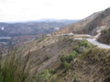
The highway did not reach Queenstown until the 1930s and was not properly surfaced for some time after that. In post cards of the 1940s and 1950s it is called the West Coast Road. Great care must be taken on the final steep descent into Queenstown, as the road is not only susceptible to ice and snow, but is narrow and twists violently.
Due to its altitude, the section of the highway over the plateau between Derwent Bridge and Mount King William is often closed during winter due to ice and snow.
With the damming of the King River
King River (Tasmania)
- Upper reaches :It rises in the vicinity of the Eldon Range, passes through the West Coast Range between Mount Huxley and Mount Jukes and empties in Macquarie Harbour near Strahan....
and the creation of Lake Burbury
Lake Burbury
Lake Burbury is a man-made lake created by the Crotty Dam made by Hydro Tasmania inundating the upper King River valley that lies east of the West Coast Range. It has a surface area of 54 square kilometres....
, the highway was re-routed to a narrow point where the Bradshaw bridge could be constructed across the lake.
External links
- http://www.parks.tas.gov.au/wha/wherein/detail.html Map of World Heritage Area