
Brisbane Transport
Encyclopedia
Brisbane Transport is a business unit of Brisbane City Council, operating suburb
an and urban
bus services under the TransLink
integrated public transport
scheme in Brisbane
, the state capital of Queensland
, Australia
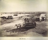
. The origins of Brisbane Transport can be seen as far back as 1885 when horse trams
serviced Brisbane. Before the council had withdrawn support in 1961, the council supported the tram
s by expanding the network and upgrading the fleet of trams. This was the start of the Brisbane City Council's investment in public transport.
In 2010, the Government of Queensland
and Brisbane City Council's support for public transport has never been higher with over 1061 buses in service, Translink
and the construction and upgrade of key infrastructure such as busways
. Brisbane Transport enjoys the use of the South-East Busway
, Boggo Road Busway, Inner-Northern Busway and the Northern Busway
, which are grade separated
from other roads and are served by large stations.
 The origins of Brisbane Transport can be seem as far back as 1885 where the Metropolitan Tramways and Investment Company established horse trams
to service Brisbane under franchise from the Queensland Government
. The tram system remained in private hands until 1922 when the Queensland government established the Brisbane Tramways Trust, compulsorily acquiring the tram network and supporting infrastructure, then in 1925 creating the Brisbane City Council and transferring responsibility for the tram network to the council. Before the council withdrew support in 1961, the council supported the tram network by expanding it and upgrading the fleet of trams.
First bus services was started in 1925 by the Brisbane City Council. Brisbane City Council shut down bus services due to financial loss in 1927, but bus services was recommenced 13 years later, in 1940. By 1940 the council was operating 12 diesel buses.
The first Rocket services began on the morning of 18 April 1977 between Garden City
and the Brisbane CBD
. These services were based on the idea that bus travel time could be reduced to less than the travel time by car by the removal of most embarkation stops.
In the 1990s, Brisbane City Council corporatised
its transport services to form Brisbane Transport, a council-owned commercial businesses managed at arm's length from the council and providing consultancy services back to it. In 2010 however government
and Brisbane City Council support for public transport have never been higher with over 1061 buses in service, Translink
, construction of key infrastructure such as busways
and upgrade of key infrastructure.
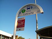 Bus upgrade zone
s (BUZ) are high-frequency bus routes mostly running direct to the Cultural Centre
. All BUZ services run at least every fifteen minutes from around 6:00am to 11:00pm seven days a week and at least every ten minutes during peak hours from Monday to Friday.
.
The route started on 22 March 2010 with a cost of $1.6 million. The route have made it easier for commuters travelling from Eight Mile Plains to get to Chermside and vice versa, without transferring at Cultural Centre
. The route completes the 30 km cross-city journey in 39 minutes instead of up to 55 minutes via the Brisbane CBD.
and Coronation Drive which links the suburbs of Eight Mile Plains, Brisbane City and Indooroopilly. The route runs every 10 minutes at peak times and 15 minutes at all other times.
The route started on the 13 December 2010. The route have made it easier for commuters travelling from Eight Mile Plains to get to Indooroopilly and vice versa, without transferring at Cultural Centre
or Brisbane City. The route takes 41 minutes to travel from terminus to terminus.
The Garden City, Toowong, Virginia and Willawong depots are equipped with compressed natural gas
refilling facilities for gas-powered buses.
Suburb
The word suburb mostly refers to a residential area, either existing as part of a city or as a separate residential community within commuting distance of a city . Some suburbs have a degree of administrative autonomy, and most have lower population density than inner city neighborhoods...
an and urban
Urban area
An urban area is characterized by higher population density and vast human features in comparison to areas surrounding it. Urban areas may be cities, towns or conurbations, but the term is not commonly extended to rural settlements such as villages and hamlets.Urban areas are created and further...
bus services under the TransLink
TransLink (South East Queensland)
The TransLink Transit Authority is the authority introduced by the Queensland Government in June 2003 as a section of Queensland Transport to coordinate and integrate rail, bus and ferry services. TransLink works with Airtrain, Brisbane Transport, Brisbane Ferries, QR Citytrain and 17 other...
integrated public transport
Public transport
Public transport is a shared passenger transportation service which is available for use by the general public, as distinct from modes such as taxicab, car pooling or hired buses which are not shared by strangers without private arrangement.Public transport modes include buses, trolleybuses, trams...
scheme in Brisbane
Brisbane
Brisbane is the capital and most populous city in the Australian state of Queensland and the third most populous city in Australia. Brisbane's metropolitan area has a population of over 2 million, and the South East Queensland urban conurbation, centred around Brisbane, encompasses a population of...
, the state capital of Queensland
Queensland
Queensland is a state of Australia, occupying the north-eastern section of the mainland continent. It is bordered by the Northern Territory, South Australia and New South Wales to the west, south-west and south respectively. To the east, Queensland is bordered by the Coral Sea and Pacific Ocean...
, Australia
Australia
Australia , officially the Commonwealth of Australia, is a country in the Southern Hemisphere comprising the mainland of the Australian continent, the island of Tasmania, and numerous smaller islands in the Indian and Pacific Oceans. It is the world's sixth-largest country by total area...
. The origins of Brisbane Transport can be seen as far back as 1885 when horse trams
Horsecar
A horsecar or horse-drawn tram is an animal-powered streetcar or tram.These early forms of public transport developed out of industrial haulage routes that had long been in existence, and from the omnibus routes that first ran on public streets in the 1820s, using the newly improved iron or steel...
serviced Brisbane. Before the council had withdrawn support in 1961, the council supported the tram
Tram
A tram is a passenger rail vehicle which runs on tracks along public urban streets and also sometimes on separate rights of way. It may also run between cities and/or towns , and/or partially grade separated even in the cities...
s by expanding the network and upgrading the fleet of trams. This was the start of the Brisbane City Council's investment in public transport.
In 2010, the Government of Queensland
Government of Queensland
The Government of Queensland is commonly known as the "Queensland Government".The form of the Government of Queensland is prescribed in its Constitution, which dates from 1859, although it has been amended many times since then...
and Brisbane City Council's support for public transport has never been higher with over 1061 buses in service, Translink
TransLink (South East Queensland)
The TransLink Transit Authority is the authority introduced by the Queensland Government in June 2003 as a section of Queensland Transport to coordinate and integrate rail, bus and ferry services. TransLink works with Airtrain, Brisbane Transport, Brisbane Ferries, QR Citytrain and 17 other...
and the construction and upgrade of key infrastructure such as busways
Bus rapid transit
Bus rapid transit is a term applied to a variety of public transportation systems using buses to provide faster, more efficient service than an ordinary bus line. Often this is achieved by making improvements to existing infrastructure, vehicles and scheduling...
. Brisbane Transport enjoys the use of the South-East Busway
South-East Busway, Brisbane
The South East Busway is a grade separated bus-only corridor running south from the Brisbane CBD to Eight Mile Plains, in South East Queensland. Service providers using the Busway operate under the TransLink system...
, Boggo Road Busway, Inner-Northern Busway and the Northern Busway
Northern Busway, Brisbane
Northern Busway is a bus-only road in Brisbane, Queensland. The busway allows buses to travel north/south through the Brisbane City without encountering car traffic. The first section of the Northern Busway opened in February 2004 had one station, QUT Kelvin Grove, later Normanby and RCH Herston...
, which are grade separated
Grade separation
Grade separation is the method of aligning a junction of two or more transport axes at different heights so that they will not disrupt the traffic flow on other transit routes when they cross each other. The composition of such transport axes does not have to be uniform; it can consist of a...
from other roads and are served by large stations.
History
Horsecar
A horsecar or horse-drawn tram is an animal-powered streetcar or tram.These early forms of public transport developed out of industrial haulage routes that had long been in existence, and from the omnibus routes that first ran on public streets in the 1820s, using the newly improved iron or steel...
to service Brisbane under franchise from the Queensland Government
Government of Queensland
The Government of Queensland is commonly known as the "Queensland Government".The form of the Government of Queensland is prescribed in its Constitution, which dates from 1859, although it has been amended many times since then...
. The tram system remained in private hands until 1922 when the Queensland government established the Brisbane Tramways Trust, compulsorily acquiring the tram network and supporting infrastructure, then in 1925 creating the Brisbane City Council and transferring responsibility for the tram network to the council. Before the council withdrew support in 1961, the council supported the tram network by expanding it and upgrading the fleet of trams.
First bus services was started in 1925 by the Brisbane City Council. Brisbane City Council shut down bus services due to financial loss in 1927, but bus services was recommenced 13 years later, in 1940. By 1940 the council was operating 12 diesel buses.
The first Rocket services began on the morning of 18 April 1977 between Garden City
Westfield Garden City
Westfield Garden City, better known as Garden City, is one of Brisbane's major shopping centres, located in the suburb of Upper Mount Gravatt. The centre is operated by Westfield, and previously operated by AMP Limited before the takeover in 2003...
and the Brisbane CBD
Brisbane central business district
The Brisbane central business district , sometimes referred to as the city, is a suburb of Brisbane, Queensland, Australia and is located on a point on the northern bank of the Brisbane River. The triangular shaped area is bounded by the Brisbane River to the east, south and west...
. These services were based on the idea that bus travel time could be reduced to less than the travel time by car by the removal of most embarkation stops.
In the 1990s, Brisbane City Council corporatised
Corporatization
Corporatization refers to the transformation of state assets or agencies into state-owned corporations in order to introduce corporate management techniques to their administration...
its transport services to form Brisbane Transport, a council-owned commercial businesses managed at arm's length from the council and providing consultancy services back to it. In 2010 however government
Government of Queensland
The Government of Queensland is commonly known as the "Queensland Government".The form of the Government of Queensland is prescribed in its Constitution, which dates from 1859, although it has been amended many times since then...
and Brisbane City Council support for public transport have never been higher with over 1061 buses in service, Translink
TransLink (South East Queensland)
The TransLink Transit Authority is the authority introduced by the Queensland Government in June 2003 as a section of Queensland Transport to coordinate and integrate rail, bus and ferry services. TransLink works with Airtrain, Brisbane Transport, Brisbane Ferries, QR Citytrain and 17 other...
, construction of key infrastructure such as busways
Bus rapid transit
Bus rapid transit is a term applied to a variety of public transportation systems using buses to provide faster, more efficient service than an ordinary bus line. Often this is achieved by making improvements to existing infrastructure, vehicles and scheduling...
and upgrade of key infrastructure.
Bus upgrade zone
Bus upgrade zone
Bus upgrade zones, commonly abbreviated to BUZ, are a feature of Brisbane's public transport system. The name is given to high-frequency bus routes operated by Brisbane Transport, the Brisbane City Council agency that operates the city's public bus services for TransLink...
s (BUZ) are high-frequency bus routes mostly running direct to the Cultural Centre
Cultural Centre Busway Station, Brisbane
The Cultural Centre Busway Station, at South Bank, is part of the South East Busway served by TransLink bus routes. The busway station is the first stop outside the city, and in Zone 1 of the TransLink integrated public transport system...
. All BUZ services run at least every fifteen minutes from around 6:00am to 11:00pm seven days a week and at least every ten minutes during peak hours from Monday to Friday.
CityGlider
CityGlider is a high frequency pre-paid bus service around the Brisbane CBD, operating every five minutes during peak and every 10 to 15 minutes during off-peak. This is the first service in Brisbane to operate 24 hours on Friday and Saturday and 18 hours every other day. Bus stops serviced by the CityGlider are identified with signs and painted kerbCurb (road)
A curb, or kerb , is the edge where a raised pavement/sidewalk/footpath, road median, or road shoulder meets an unraised street or other roadway.-Function:...
.
CLEM7
CLEM7 (Route 77) is a bus route using the Clem Jones Tunnel (CLEM7) which links the suburbs of Eight Mile Plains and Chermside, the route runs every 15 minutes at peak times and 30 minutes at off-peak, Monday to Friday.The route started on 22 March 2010 with a cost of $1.6 million. The route have made it easier for commuters travelling from Eight Mile Plains to get to Chermside and vice versa, without transferring at Cultural Centre
Cultural Centre Busway Station, Brisbane
The Cultural Centre Busway Station, at South Bank, is part of the South East Busway served by TransLink bus routes. The busway station is the first stop outside the city, and in Zone 1 of the TransLink integrated public transport system...
. The route completes the 30 km cross-city journey in 39 minutes instead of up to 55 minutes via the Brisbane CBD.
P88
P88 is a prepaid fare bus route using the South East Busway, Captain Cook BridgeCaptain Cook Bridge, Brisbane
The Captain Cook Bridge is a motorway bridge over the Brisbane River in Brisbane, Australia. It was built exclusively for vehicular traffic and was opened in 1972. The bridge crosses at the South Brisbane Reach of the river, linking Gardens Point to Woolloongabba.Captain Cook Bridge actually...
and Coronation Drive which links the suburbs of Eight Mile Plains, Brisbane City and Indooroopilly. The route runs every 10 minutes at peak times and 15 minutes at all other times.
The route started on the 13 December 2010. The route have made it easier for commuters travelling from Eight Mile Plains to get to Indooroopilly and vice versa, without transferring at Cultural Centre
Cultural Centre Busway Station, Brisbane
The Cultural Centre Busway Station, at South Bank, is part of the South East Busway served by TransLink bus routes. The busway station is the first stop outside the city, and in Zone 1 of the TransLink integrated public transport system...
or Brisbane City. The route takes 41 minutes to travel from terminus to terminus.
Fleet
Brisbane Transport currently operates approximately 1162 buses.Depots
Brisbane Transport operates its services from eight different depots around the Brisbane City Council area. Many of these depots can share routes with other depots in overlapping areas. Generally, each of Brisbane Transport's buses are allocated to a particular depot, and displays a letter prefix for that depot before its bus number on at least the front and rear of its body, and occasionally rooftops.Current
- Bowen HillsBowen Hills, QueenslandBowen Hills is an inner suburb of Brisbane, Australia, located 3 km northeast of the Brisbane CBD. It was named after a Governor of Queensland, Sir George Ferguson Bowen.-History:...
("A") 27.435975°N 153.042313°W – serves some northern routes and operates all routes between New Farm and West End. - CarinaCarina, QueenslandCarina is an eastern suburb of Brisbane, Queensland, Australia about 7 kilometres from the Central Business District. It adjoins the suburbs of Carindale, Carina Heights, Cannon Hill and Camp Hill....
("C") 27.490371°N 153.102078°W – serves all eastern routes and some south-eastern routes from Garden City to Wynnum and Bulimba. - Garden CityUpper Mount Gravatt, QueenslandUpper Mount Gravatt is a suburb in Brisbane, to the south of Mount Gravatt. It has increasingly become an important centre in the last 15 years...
("G") 27.56655°N 153.086731°W – serves south-eastern routes from Browns Plains and Sunnybank, to Wishart and Coorparoo. This depot is also the location of Brisbane Transport's head office. - LarapintaLarapinta, QueenslandLarapinta is a suburb located in the southern regions of Brisbane, on the edge of the Logan shire. The suburb is sparsely populated, being mostly bushland, save for the recent construction of industry. The industrial area has become a new addition to the expansion of Brisbane's industry, including...
("L") 27.643171°N 153.007364°W – a satellite depot of Carina, Garden City and Willawong depots, it shares southern, western and eastern services. Originally a temporary bus depot until the Willawong depot opened, it still remains open as a satellite depot, sharing routes with other southern depots. - RichlandsRichlands, QueenslandRichlands is an outer suburb of Brisbane, Australia. It is 16 km south-west of the CBD.-External links:* *...
("R") 27.601259°N 152.957395°W – a satellite depot of the Toowong depot, it shares services on western routes, and some services to Garden City. - ToowongToowong, QueenslandToowong is an inner suburb of Brisbane, Australia which is located 5 km west of the Brisbane CBD. At the centre of Toowong is a commercial precinct including Toowong Village and several office buildings...
("T") 27.479235°N 152.983482°W – serves South Western and North West Routes from Brookside and The Gap, to Inala and Forest Lake. - VirginiaVirginia, QueenslandVirginia is a suburb in Brisbane, Queensland, Australia. It is located 10 km north of the Brisbane central business district. It is primarily a residential suburb with many timber and tin Queenslander style housing...
("V") 27.365889°N 153.060885°W – serves the majority of northern routes from Nudgee Beach and Brighton, to Brookside and the Gap. - WillawongWillawong, QueenslandWillawong is an outer suburb of Brisbane, Australia. It is 16 km south of the CBD.Willawong is an Aboriginal meaning ‘the junction of two creeks’.This suburb has one of the Brisbane Transport bus depots located within the suburb.-External links:*...
("W") 27.598531°N 153.004103°W – serves primarily Southern routes, and shares routes with other southern depots.
The Garden City, Toowong, Virginia and Willawong depots are equipped with compressed natural gas
Compressed natural gas
Compressed natural gas is a fossil fuel substitute for gasoline , diesel, or propane/LPG. Although its combustion does produce greenhouse gases, it is a more environmentally clean alternative to those fuels, and it is much safer than other fuels in the event of a spill...
refilling facilities for gas-powered buses.
Former
- Bracken RidgeBracken Ridge, QueenslandBracken Ridge is a northern suburb of Brisbane, the capital city of Queensland, Australia. Its local government area is the City of Brisbane, in which it has its own ward.-Location:...
("B") 27.331658°N 153.02982°W – only ever considered a short-term depot by Brisbane Transport, it was closed in 2001, several years after the Virginia depot had opened. - Cribb Street, MiltonMilton, QueenslandMilton is an inner suburb of Brisbane, Australia, located approximately west of Brisbane's central business district. The suburb is a mixture of light industry, warehouses, commercial offices, retail and single and multiple occupancy residences...
27.469226°N 153.007858°W – never a formal depot, this area of land was occasionally used by the council as temporary storage for buses owing to its proximity to the Milton bus and tram workshops. Last used in 1983. - Ipswich Road, WoolloongabbaWoolloongabba, QueenslandWoolloongabba is an inner suburb of Brisbane, Australia located 4 km south of the Brisbane CBD.Experts are divided regarding the Aboriginal meaning of the name, preferring either 'whirling waters' or 'fight talk place'...
27.489505°N 153.035731°W – shared with trams, buses parked in the depot forecourt and at the rear (eastern end) of the tram sheds. Between 1969 and 1974, the depot was used solely by buses. The site was subsequently sold by the Brisbane City Council for commercial redevelopment. One bay of the depot building was dismantled and re-erected at the Brisbane Tramway MuseumBrisbane Tramway MuseumBrisbane Tramway Museum is a transport museum which preserves and displays trams and trolley-buses, most of which operated in Brisbane, Queensland, Australia. The museum also has a collection of vehicles and other equipment used in maintaining Brisbane's electric street transport system which...
at Ferny GroveFerny Grove, QueenslandFerny Grove is a residential suburb in north-west Brisbane, Queensland, Australia. It lies entirely within the Brisbane-metropolitan area administered by the Brisbane City Council.-General information:...
. - Light Street, NewsteadNewstead, QueenslandNewstead is a riverside suburb of the city of Brisbane, Queensland, Australia. It is situated 3 km north of the Brisbane central business district...
("L") 27.451323°N 153.038617°W – closed for commercial redevelopment, first used as a transport depot in 1885 when it was the main tram depot for Brisbane's horse tram network. Until 1968, the depot was shared with trams with buses parked along the western (Wickham Street) frontage and north of the tram shed. When the tram shed was demolished, buses were parked where the shed once stood. - MiltonMilton, QueenslandMilton is an inner suburb of Brisbane, Australia, located approximately west of Brisbane's central business district. The suburb is a mixture of light industry, warehouses, commercial offices, retail and single and multiple occupancy residences...
27.467217°N 153.00958°W – shared with trolleybuses and closed when the trolleybus network was abandoned in 1969. The site is now part of the King's Row business park, although the Brisbane City Council still has a parks works depot there.