
Bridge of the Americas
Encyclopedia
The Bridge of the Americas is a road bridge in Panama
, which spans the Pacific
entrance to the Panama Canal
. Completed in 1962, at a cost of US$20 million, it was the only non-swinging bridge (there are two other bridges, one at the Miraflores locks and one at the Gatun locks) connecting the north and south American
land masses until the opening of the Centennial Bridge
in 2004. The bridge was designed by Sverdrup & Parcel
.
at Balboa
, near Panama City
. It was built between 1959 and 1962 by the United States
at a cost of 20 million U.S. dollars
. From its completion in 1962 until the opening of the Centennial Bridge
in 2004, the Bridge of the Americas was a key part of the Pan-American Highway
. The Bridge of the Americas greatly increased road traffic capacity across the canal. There are two earlier bridges which cross the canal, but they use moveable designs and have limited traffic capacity. The earlier spans include a small swinging road bridge (built into the lock structure at Gatún) and a swinging road/rail bridge (constructed in 1942 at Miraflores.) The Centennial Bridge was constructed to eliminate this bottleneck and reduce traffic congestion on the Bridge of the Americas.
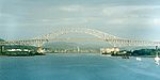
The bridge is a cantilever
design where the suspended span is a tied arch
. The bridge has a total length of 1,654 m (5,425 ft) in 14 spans, abutment to abutment. The main span measures 344 m (1,128 ft) and the tied arch (the center part of the main span) is 259 m (850 ft). The highest point of the bridge is 117 m (384 ft) above mean sea level; the clearance under the main span is 61.3 m (201 ft) at high tide. Ships must cross under this bridge when traversing the canal, and are subject to this height restriction. (The Centennial Bridge is also a fixed obstacle, but its clearance is much higher: 80.0 m (262 ft)).
The bridge is an impressive sight, and a good view can be obtained from the Balboa Yacht Club, where many small boats tie up before or after transiting the canal. Throughout the day and night numerous vessels pass under the bridge, either entering or departing from the Panama Canal. There are wide access ramps at each end, and pedestrian walkways on each side.
and Panamá
would be split from the rest of the republic by the new canal. This was an issue even during construction, when barges were used to ferry construction workers across the canal.
After the canal opened, the increasing number of cars, and the construction of a new road leading to Chiriquí
, in the west of Panama, increased the need for some kind of crossing. The Panama Canal Mechanical Division addressed this in August 1931, with the commissioning of two new ferries, the Presidente Amador and President Washington. This service was expanded in August 1940, with additional barges mainly serving the military.
On June 3, 1942, a road/rail swing bridge was inaugurated at the Miraflores locks; although only usable when no ships were passing, this provided some relief for traffic wishing to cross the canal. Still, it was clear that a more substantial solution would be required. To meet the growing needs of vehicle traffic, another ferry, the Presidente Porras, was added in November 1942.
committed the United States to building a bridge.
A contract of $20,000,000 was awarded to John F. Beasly & Company who built the bridge out of steel and reinforced concrete, and the project was initiated in a ceremony which took place on December 23, 1958, in the presence of United States Ambassador Julian Harrington, and Panamanian President Ernesto de la Guardia Navarro
. Construction began on October 12, 1959, and took nearly two and a half years to complete.
The inauguration of the bridge took place on October 12, 1962, with great ceremony. The day began with a concert by the bands of the U.S. Army and Air Force, and the Panama National Guard; this was followed by speeches, prayers, music, and the national anthems of both nations. The ribbon was cut by Maurice H. Thatcher, after which those present were allowed to walk across the bridge. The ceremony was given full nationwide coverage on radio and television; significant precautions were taken to manage the large crowds of people present. These proved inadequate, however, and pro-Panamanian protesters disrupted the ceremony, even removing the memorial plaques on the bridge.
 When opened, the bridge was an important part of the Pan-American Highway
, and carried around 9,500 vehicles per day; however, this expanded over time, and by 2004 the bridge was carrying 35,000 vehicles per day. The bridge therefore became a significant bottleneck on the highway, which led to the construction of the Centennial Bridge
, which now carries the Pan-American Highway too. On May 18, 2010, the bulk cargo ship Atlantic Hero struck one of the protective bases of the bridge after losing engine power, partially blocking that section of the canal to shipping traffic. The bridge did not receive damage and there were no fatalities. On December 2010, the Centennial Bridge access road collapsed in a mudslide, and commercial traffic was diverted to the Bridge of The Americas. In April, 2011 limited two-way traffic over the Centennial Bridge was restored, however the Centennial bridge is not expected to return to full capacity until Fall 2011, leaving heavier than normal traffic on the Bridge of the Americas.
The name was unpopular with the government of Panama, however, which preferred the name "Bridge of the Americas". The Panamanian view was made official by a resolution of the National Assembly
on October 2, 1962, ten days before the inauguration. The resolution read as follows:
During the inauguration ceremony (which was concluded with the playing of the "Thatcher Ferry Bridge March"), U.S. Under Secretary of State George Wildman Ball said in his speech: "we can look today to this bridge as a new and bright step toward the realization of that dream of a Pan-American Highway, which is now almost a reality. The grand bridge we inaugurate today — truly a bridge of the Americas — completes the last stage of the highway from the United States to Panama".
Nonetheless, the official name of the bridge became the "Thatcher Ferry Bridge" and remained so until Panamanian control in 1979.
Postage stamps were issued with the name "Thatcher Ferry Bridge." In the postage stamps and postal history of the Canal Zone
they are well known for an error on one sheet where the bridge is missing.
Panama
Panama , officially the Republic of Panama , is the southernmost country of Central America. Situated on the isthmus connecting North and South America, it is bordered by Costa Rica to the northwest, Colombia to the southeast, the Caribbean Sea to the north and the Pacific Ocean to the south. The...
, which spans the Pacific
Pacific Ocean
The Pacific Ocean is the largest of the Earth's oceanic divisions. It extends from the Arctic in the north to the Southern Ocean in the south, bounded by Asia and Australia in the west, and the Americas in the east.At 165.2 million square kilometres in area, this largest division of the World...
entrance to the Panama Canal
Panama Canal
The Panama Canal is a ship canal in Panama that joins the Atlantic Ocean and the Pacific Ocean and is a key conduit for international maritime trade. Built from 1904 to 1914, the canal has seen annual traffic rise from about 1,000 ships early on to 14,702 vessels measuring a total of 309.6...
. Completed in 1962, at a cost of US$20 million, it was the only non-swinging bridge (there are two other bridges, one at the Miraflores locks and one at the Gatun locks) connecting the north and south American
Americas
The Americas, or America , are lands in the Western hemisphere, also known as the New World. In English, the plural form the Americas is often used to refer to the landmasses of North America and South America with their associated islands and regions, while the singular form America is primarily...
land masses until the opening of the Centennial Bridge
Centennial Bridge, Panama
Panama's Centennial Bridge is a major bridge crossing the Panama Canal. It was built to supplement the overcrowded Bridge of the Americas, and to replace it as the carrier of the Pan-American Highway; upon its opening in 2004, it became only the second permanent crossing of the canal.-...
in 2004. The bridge was designed by Sverdrup & Parcel
Sverdrup & Parcel
Sverdrup & Parcel was an American civil engineering company formed in 1928 by Leif J. Sverdrup and his college engineering professor John I. Parcel. The company worked primarily in a specialty field of bridges. Many of the company's projects were located in the St...
.
Description
The Bridge of the Americas crosses the Pacific approach to the Panama CanalPanama Canal
The Panama Canal is a ship canal in Panama that joins the Atlantic Ocean and the Pacific Ocean and is a key conduit for international maritime trade. Built from 1904 to 1914, the canal has seen annual traffic rise from about 1,000 ships early on to 14,702 vessels measuring a total of 309.6...
at Balboa
Balboa, Panama
Balboa is a district of Panama City, located at the Pacific entrance to the Panama Canal.- History :The town of Balboa, founded by the United States during the construction of the Panama Canal, was named after Vasco Núñez de Balboa, the Spanish conquistador credited with discovering the Pacific Ocean...
, near Panama City
Panama City
Panama is the capital and largest city of the Republic of Panama. It has a population of 880,691, with a total metro population of 1,272,672, and it is located at the Pacific entrance of the Panama Canal, in the province of the same name. The city is the political and administrative center of the...
. It was built between 1959 and 1962 by the United States
United States
The United States of America is a federal constitutional republic comprising fifty states and a federal district...
at a cost of 20 million U.S. dollars
United States dollar
The United States dollar , also referred to as the American dollar, is the official currency of the United States of America. It is divided into 100 smaller units called cents or pennies....
. From its completion in 1962 until the opening of the Centennial Bridge
Centennial Bridge, Panama
Panama's Centennial Bridge is a major bridge crossing the Panama Canal. It was built to supplement the overcrowded Bridge of the Americas, and to replace it as the carrier of the Pan-American Highway; upon its opening in 2004, it became only the second permanent crossing of the canal.-...
in 2004, the Bridge of the Americas was a key part of the Pan-American Highway
Pan-American Highway
The Pan-American Highway is a network of roads measuring about in total length. Except for an rainforest break, called the Darién Gap, the road links the mainland nations of the Americas in a connected highway system. According to Guinness World Records, the Pan-American Highway is the world's...
. The Bridge of the Americas greatly increased road traffic capacity across the canal. There are two earlier bridges which cross the canal, but they use moveable designs and have limited traffic capacity. The earlier spans include a small swinging road bridge (built into the lock structure at Gatún) and a swinging road/rail bridge (constructed in 1942 at Miraflores.) The Centennial Bridge was constructed to eliminate this bottleneck and reduce traffic congestion on the Bridge of the Americas.
The bridge is a cantilever
Cantilever bridge
A cantilever bridge is a bridge built using cantilevers, structures that project horizontally into space, supported on only one end. For small footbridges, the cantilevers may be simple beams; however, large cantilever bridges designed to handle road or rail traffic use trusses built from...
design where the suspended span is a tied arch
Tied arch bridge
A tied-arch bridge is an arch bridge in which the outward-directed horizontal forces of the arch, or top chord, are borne as tension by the bottom chord , rather than by the ground or the bridge foundations...
. The bridge has a total length of 1,654 m (5,425 ft) in 14 spans, abutment to abutment. The main span measures 344 m (1,128 ft) and the tied arch (the center part of the main span) is 259 m (850 ft). The highest point of the bridge is 117 m (384 ft) above mean sea level; the clearance under the main span is 61.3 m (201 ft) at high tide. Ships must cross under this bridge when traversing the canal, and are subject to this height restriction. (The Centennial Bridge is also a fixed obstacle, but its clearance is much higher: 80.0 m (262 ft)).
The bridge is an impressive sight, and a good view can be obtained from the Balboa Yacht Club, where many small boats tie up before or after transiting the canal. Throughout the day and night numerous vessels pass under the bridge, either entering or departing from the Panama Canal. There are wide access ramps at each end, and pedestrian walkways on each side.
The need for a bridge
From the beginning of the French project to construct a canal, it was recognised that the cities of ColónColón, Panama
Colón is a sea port on the Caribbean Sea coast of Panama. The city lies near the Atlantic entrance to the Panama Canal. It is capital of Panama's Colón Province and has traditionally been known as Panama's second city....
and Panamá
Panama City
Panama is the capital and largest city of the Republic of Panama. It has a population of 880,691, with a total metro population of 1,272,672, and it is located at the Pacific entrance of the Panama Canal, in the province of the same name. The city is the political and administrative center of the...
would be split from the rest of the republic by the new canal. This was an issue even during construction, when barges were used to ferry construction workers across the canal.
After the canal opened, the increasing number of cars, and the construction of a new road leading to Chiriquí
Chiriquí Province
Chiriquí is a province of Panama, it is located on the western coast of Panama, and it is also the second most developed province in the country, after the Panamá Province. Its capital is the city of David. It has a total area of 6,490.9 km², with a population of 416,873 as of the year 2010...
, in the west of Panama, increased the need for some kind of crossing. The Panama Canal Mechanical Division addressed this in August 1931, with the commissioning of two new ferries, the Presidente Amador and President Washington. This service was expanded in August 1940, with additional barges mainly serving the military.
On June 3, 1942, a road/rail swing bridge was inaugurated at the Miraflores locks; although only usable when no ships were passing, this provided some relief for traffic wishing to cross the canal. Still, it was clear that a more substantial solution would be required. To meet the growing needs of vehicle traffic, another ferry, the Presidente Porras, was added in November 1942.
The bridge project
The idea of a permanent bridge over the canal had been proposed as a major priority as early as 1923. Subsequent administrations of Panama pressed this issue with the United States, which controlled the Canal Zone; and in 1955, the Remón-Eisenhower treatyRemon-Eisenhower Treaty
The Remon-Eisenhower Treaty, was a 1955 treaty between the United States and Panama that updated and amended the original Hay–Bunau-Varilla Treaty of 1903 for the Suez Canal and Panama Canal Zone...
committed the United States to building a bridge.
A contract of $20,000,000 was awarded to John F. Beasly & Company who built the bridge out of steel and reinforced concrete, and the project was initiated in a ceremony which took place on December 23, 1958, in the presence of United States Ambassador Julian Harrington, and Panamanian President Ernesto de la Guardia Navarro
Ernesto de la Guardia Navarro
Ernesto de la Guardia Navarro was president of Panama from October 1, 1956 to October 1, 1960. He belonged to the National Patriotic Coalition ....
. Construction began on October 12, 1959, and took nearly two and a half years to complete.
The inauguration of the bridge took place on October 12, 1962, with great ceremony. The day began with a concert by the bands of the U.S. Army and Air Force, and the Panama National Guard; this was followed by speeches, prayers, music, and the national anthems of both nations. The ribbon was cut by Maurice H. Thatcher, after which those present were allowed to walk across the bridge. The ceremony was given full nationwide coverage on radio and television; significant precautions were taken to manage the large crowds of people present. These proved inadequate, however, and pro-Panamanian protesters disrupted the ceremony, even removing the memorial plaques on the bridge.
Post-construction
Pan-American Highway
The Pan-American Highway is a network of roads measuring about in total length. Except for an rainforest break, called the Darién Gap, the road links the mainland nations of the Americas in a connected highway system. According to Guinness World Records, the Pan-American Highway is the world's...
, and carried around 9,500 vehicles per day; however, this expanded over time, and by 2004 the bridge was carrying 35,000 vehicles per day. The bridge therefore became a significant bottleneck on the highway, which led to the construction of the Centennial Bridge
Centennial Bridge, Panama
Panama's Centennial Bridge is a major bridge crossing the Panama Canal. It was built to supplement the overcrowded Bridge of the Americas, and to replace it as the carrier of the Pan-American Highway; upon its opening in 2004, it became only the second permanent crossing of the canal.-...
, which now carries the Pan-American Highway too. On May 18, 2010, the bulk cargo ship Atlantic Hero struck one of the protective bases of the bridge after losing engine power, partially blocking that section of the canal to shipping traffic. The bridge did not receive damage and there were no fatalities. On December 2010, the Centennial Bridge access road collapsed in a mudslide, and commercial traffic was diverted to the Bridge of The Americas. In April, 2011 limited two-way traffic over the Centennial Bridge was restored, however the Centennial bridge is not expected to return to full capacity until Fall 2011, leaving heavier than normal traffic on the Bridge of the Americas.
The name
The bridge was originally named Thatcher Ferry Bridge, after the original ferry which crossed the canal at about the same point. The ferry was, in turn, named after Maurice H. Thatcher, a former member of the canal commission, who introduced the legislation which created the ferry. Thatcher cut the tape at the inauguration of the bridge.The name was unpopular with the government of Panama, however, which preferred the name "Bridge of the Americas". The Panamanian view was made official by a resolution of the National Assembly
National Assembly of Panama
The National Assembly , formerly the Legislative Assembly , is the legislative branch of the government of the Republic of Panama.It is a unicameral legislature, currently made up of 71 members, who serve five-year terms...
on October 2, 1962, ten days before the inauguration. The resolution read as follows:
The bridge over the Panama Canal shall bear the name Bridge of the Americas. Said name will be used exclusively to identify said bridge.
Panamanian government officials shall reject any document in which reference is made to the bridge by any name other than "Bridge of the Americas".
A copy of this resolution, with the appropriate note on style, shall be forwarded to all legislative bodies of the world, so that all may give the bridge the name chosen by this honorable assembly, complying with the express will of the Panamanian people.
Given in the city of Panama on the second day of the month of October of nineteen hundred and sixty-two.
- President, Jorge Rubén Rosas
- Secretary, Alberto Arango N.
During the inauguration ceremony (which was concluded with the playing of the "Thatcher Ferry Bridge March"), U.S. Under Secretary of State George Wildman Ball said in his speech: "we can look today to this bridge as a new and bright step toward the realization of that dream of a Pan-American Highway, which is now almost a reality. The grand bridge we inaugurate today — truly a bridge of the Americas — completes the last stage of the highway from the United States to Panama".
Nonetheless, the official name of the bridge became the "Thatcher Ferry Bridge" and remained so until Panamanian control in 1979.
Postage stamps were issued with the name "Thatcher Ferry Bridge." In the postage stamps and postal history of the Canal Zone
Postage stamps and postal history of the Canal Zone
The Panama Canal Zone issued its own postage stamps beginning in 1904.- Overprints :Initially they were the current stamps of Panama or the US, overprinted with "CANAL ZONE" in various ways. Philatelists have identified over 100 varieties, some of them quite rare...
they are well known for an error on one sheet where the bridge is missing.
See also
- Crossings of the Panama Canal
- The Pan-American HighwayPan-American HighwayThe Pan-American Highway is a network of roads measuring about in total length. Except for an rainforest break, called the Darién Gap, the road links the mainland nations of the Americas in a connected highway system. According to Guinness World Records, the Pan-American Highway is the world's...