
Boyd, Oregon
Encyclopedia
Boyd was a town in Wasco County
, Oregon
, United States
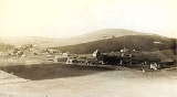
, disincorporated in 1955, and now vacant except for a few abandoned homes, weathered outbuildings, and a derelict wooden grain elevator surrounded by the wheat
fields, which still produce the grain that used to fill it. The site of the former settlement is located 9.5 miles southeast of The Dalles
, on the east side of U.S. Route 197 from which it is visible at a distance.
would have passed through or near Boyd as early as 1847, but the earliest recorded community was established over a decade later, when gold was discovered near John Day
in 1861, and a larger strike the next year in Canyon City, Oregon
.
The spot near the banks of Fifteenmile Creek
that would become the community of Boyd was already a stagecoach
stop, with an inn, Eleven Mile House. The area became a busy one when as many as 150 miners, 200 pack animals, and ten to twelve freight wagons left The Dalles
for Canyon City
every day. Freight wagon and pack team traffic brought the need for wayfarer accommodations, a blacksmith, wheelwrights and livery stables, so a community developed around Eleven Mile House. It also served the growing number of homesteaders farming in the immediate vicinity.
In 1863, a schoolhouse was built on Fifteenmile Creek east of Boyd. The school building was also used for religious services. The community continued to grow. A flour mill was built, ultimately purchased by a T.P. Boyd and his four sons, after whom the town was to be named. The U.S. Government granted a post office under that name, which was located in the general store.
The community still increasing in size, a town plat
was drawn in 1895, several businesses sprang up, and a Methodist
church established, sharing a pastor with the congregation in Dufur, Oregon
. The Boyd school became District #21.
 The Great Southern Railroad
began passing directly through town in 1905 and carrying passengers, freight, mail and wheat
, and Boyd thrived until the 1923 construction of The Dalles-California Highway, now U.S. Route 197, bypassed the town. The following years were difficult for the little town. The Great Depression
took its toll on local business, already suffering from low wheat prices and decreasing numbers of travelers whom those businesses served. The convenience of trips to nearby Dufur and The Dalles made merchant services in Boyd superfluous. The Post office was closed in 1952.
Wasco County, Oregon
Wasco County is a county located in the U.S. state of Oregon. The county is named for a local tribe of Native Americans, the Wasco, a Chinook tribe who lived on the south side of the Columbia River. In 2010, its population was 25,213...
, Oregon
Oregon
Oregon is a state in the Pacific Northwest region of the United States. It is located on the Pacific coast, with Washington to the north, California to the south, Nevada on the southeast and Idaho to the east. The Columbia and Snake rivers delineate much of Oregon's northern and eastern...
, United States
United States
The United States of America is a federal constitutional republic comprising fifty states and a federal district...
, disincorporated in 1955, and now vacant except for a few abandoned homes, weathered outbuildings, and a derelict wooden grain elevator surrounded by the wheat
Wheat
Wheat is a cereal grain, originally from the Levant region of the Near East, but now cultivated worldwide. In 2007 world production of wheat was 607 million tons, making it the third most-produced cereal after maize and rice...
fields, which still produce the grain that used to fill it. The site of the former settlement is located 9.5 miles southeast of The Dalles
The Dalles, Oregon
The Dalles is the largest city and county seat of Wasco County, Oregon, United States. The name of the city comes from the French word dalle The Dalles is the largest city and county seat of Wasco County, Oregon, United States. The name of the city comes from the French word dalle The Dalles is...
, on the east side of U.S. Route 197 from which it is visible at a distance.
History
During the western migration, settlers traversing the Barlow RoadBarlow Road
The Barlow Road is a historic road in what is now the U.S. state of Oregon. It was built in 1846 by Sam Barlow and Philip Foster, with authorization of the Provisional Legislature of Oregon, and served as the last overland segment of the Oregon Trail...
would have passed through or near Boyd as early as 1847, but the earliest recorded community was established over a decade later, when gold was discovered near John Day
John Day, Oregon
John Day is a city located about north of Canyon City in Grant County, Oregon, at the intersection of U.S. Routes 26 and 395. The city was named for the nearby John Day River, which had been named for a Virginian member of the 1811 Astor Expedition, John Day...
in 1861, and a larger strike the next year in Canyon City, Oregon
Canyon City, Oregon
Canyon City is a city in Grant County, Oregon, United States. It is the county seat of Grant County, and is about a mile south of John Day on U.S. Highway 395. As of the 2010 census, the city had a total population of 703.-History:...
.
The spot near the banks of Fifteenmile Creek
Fifteenmile Creek (Columbia River)
Fifteenmile Creek is a long tributary of the Columbia River, located in the U.S. state of Oregon. It drains of Hood River and Wasco counties...
that would become the community of Boyd was already a stagecoach
Stagecoach
A stagecoach is a type of covered wagon for passengers and goods, strongly sprung and drawn by four horses, usually four-in-hand. Widely used before the introduction of railway transport, it made regular trips between stages or stations, which were places of rest provided for stagecoach travelers...
stop, with an inn, Eleven Mile House. The area became a busy one when as many as 150 miners, 200 pack animals, and ten to twelve freight wagons left The Dalles
The Dalles, Oregon
The Dalles is the largest city and county seat of Wasco County, Oregon, United States. The name of the city comes from the French word dalle The Dalles is the largest city and county seat of Wasco County, Oregon, United States. The name of the city comes from the French word dalle The Dalles is...
for Canyon City
Canyon City, Oregon
Canyon City is a city in Grant County, Oregon, United States. It is the county seat of Grant County, and is about a mile south of John Day on U.S. Highway 395. As of the 2010 census, the city had a total population of 703.-History:...
every day. Freight wagon and pack team traffic brought the need for wayfarer accommodations, a blacksmith, wheelwrights and livery stables, so a community developed around Eleven Mile House. It also served the growing number of homesteaders farming in the immediate vicinity.
In 1863, a schoolhouse was built on Fifteenmile Creek east of Boyd. The school building was also used for religious services. The community continued to grow. A flour mill was built, ultimately purchased by a T.P. Boyd and his four sons, after whom the town was to be named. The U.S. Government granted a post office under that name, which was located in the general store.
The community still increasing in size, a town plat
Plat
A plat in the U.S. is a map, drawn to scale, showing the divisions of a piece of land. Other English-speaking countries generally call such documents a cadastral map or plan....
was drawn in 1895, several businesses sprang up, and a Methodist
Methodism
Methodism is a movement of Protestant Christianity represented by a number of denominations and organizations, claiming a total of approximately seventy million adherents worldwide. The movement traces its roots to John Wesley's evangelistic revival movement within Anglicanism. His younger brother...
church established, sharing a pastor with the congregation in Dufur, Oregon
Dufur, Oregon
Dufur is a city in Wasco County, Oregon, United States. The population was 588 at the 2000 census. It is a farming community, with wheat being an important crop, along with tree fruit and grapes....
. The Boyd school became District #21.
Great Southern Railroad
The Great Southern Railroad was a 41-mile short-line which connected to the Oregon Railway and Navigation Company, later the Oregon-Washington Railway and Navigation Company , in The Dalles, Oregon, United States, and ran south along Fifteen Mile Creek through Boyd to Dufur, and on to the small...
began passing directly through town in 1905 and carrying passengers, freight, mail and wheat
Wheat
Wheat is a cereal grain, originally from the Levant region of the Near East, but now cultivated worldwide. In 2007 world production of wheat was 607 million tons, making it the third most-produced cereal after maize and rice...
, and Boyd thrived until the 1923 construction of The Dalles-California Highway, now U.S. Route 197, bypassed the town. The following years were difficult for the little town. The Great Depression
Great Depression
The Great Depression was a severe worldwide economic depression in the decade preceding World War II. The timing of the Great Depression varied across nations, but in most countries it started in about 1929 and lasted until the late 1930s or early 1940s...
took its toll on local business, already suffering from low wheat prices and decreasing numbers of travelers whom those businesses served. The convenience of trips to nearby Dufur and The Dalles made merchant services in Boyd superfluous. The Post office was closed in 1952.
Further reading
- Zopf, Nancy Ward. 2001. A Road, a Railroad, and a Country Store; The Story of Boyd Oregon. Wasco County Historical Museum Press, The Dalles, Oregon.