
Bledsoe's Station
Encyclopedia
Bledsoe's Station was an 18th-century frontier fort located in what is now Castalian Springs, Tennessee
, in the southeastern United States. The fort was built by long hunter
and Sumner County
pioneer Isaac Bledsoe (c. 1735–1793) in the early 1780s to protect Upper Cumberland settlers and migrants from hostile Native American
attacks. While the fort is no longer standing, its location has been verified by archaeological excavations. The site is now part of Bledsoe's Fort Historical Park, a public park established in 1989 by Sumner County residents and Bledsoe's descendants.
Bledsoe's Station was one of a series of outposts built in the Upper Cumberland during the first major migration of Euro-American settlers into the Middle Tennessee area following the American Revolution
. The fort was a convenient stopover along Avery's Trace— the main road connecting East and Middle Tennessee at the time. The flood of settlers into the region brought inevitable conflict with the region's Native American inhabitants, and dozens of settlers were killed in the late 1780s and early 1790s. Isaac Bledsoe's brother Anthony (1733–1788) was killed in an ambush at the fort in 1788 and Isaac himself was killed while tending a field just outside the fort in 1793. The end of the Chickamauga Wars
the following year ended much of the violence and reduced the fort's necessity.
Bledsoe's Fort Historical Park protects the fort's excavation site (an outline of the fort's walls can be discerned from former excavation trenches) as well as several historic structures, including the Nathaniel Parker Cabin and Hugh Rogan Cottage (both Parker and Rogan were compatriots of Bledsoe) and a pioneer cemetery with an obelisk dedicated to the Bledsoe brothers. The Cheskiki Indian Mounds and the Wynnewood State Historical Site
are located immediately east of the park, and the Cragfont State Historical Site
is located immediately to the west.
just over a mile to the south. The hill is relatively blunt and consists of open fields alternating with densely forested areas. The top of the hill is used as a flying zone for radio-controlled airplanes. The spring that furnished the minerals for Bledsoe's Lick flows at the base of the hill a few hundred yards east of the fort site.
Bledsoe's Fort Historical Park covers most of the hill between the Sumner County RC Flyers airfield and Rock Springs Road. Tennessee State Route 25 (Hartsville Pike) provides the park's southern boundary and main access. The park is roughly halfway between Hartsville
to the east and Gallatin to the west, and lies approximately 35 miles (56.3 km) northeast of Nashville
.
 For thousands of years, the mineral springs at Bledsoe's Lick attracted buffalo and other large animals, and subsequently drew Native American
hunters to the area. Native Americans were hunting around Bledsoe's Lick as early as 12,000 years ago during the Paleo-Indian period, and camped sporadically in the area throughout the Archaic (8000-1000 BC) and Woodland
(1000 BC - 1000 AD) periods. During the Mississippian period
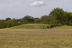
(c. 1000–1450 AD), a substantial village had been established at the Castalian Springs Mound Site
, a few hundred yards from the mineral springs. The village covered 40 acre (0.1618744 km²) and contained at least 12 mounds. By the time the first Euro-American explorers arrived in the area in the mid-18th century, the Cherokee
, Chickasaw
, and Creek claimed the area as a hunting ground.
Among the first documented English explorers in the Upper Cumberland region were the long hunters, so-called because of the long duration of their hunting expeditions. The long hunters typically followed the Cumberland River and its headwaters from southwestern Virginia into Middle Tennessee. Expeditions led by Henry Scaggs
in 1765 and James Smith in 1766 passed through what is now Sumner County and hunted extensively in the Upper Cumberland region. In 1769, an expedition led by Kasper Mansker spent several months in the Upper Cumberland area, eventually sending two canoes full of furs downriver to Natchez, Mississippi
. Mansker returned to the Upper Cumberland in 1771 with a larger group of hunters— among them Isaac Bledsoe— and collected several thousand skins. In 1772, Mansker and Bledsoe led a third expedition to the Upper Cumberland region. This group established a base camp along Station Camp Creek (giving the creek its name) a few miles to the west near Gallatin. It was during this third expedition that Bledsoe followed the ancient buffalo paths to the creek and salt lick that now bear his name, and where he would eventually construct his fort.
In the late 1770s, long hunter and explorer Thomas "Bigfoot" Spencer led a hunting expedition that camped near Bledsoe's Lick. Spencer remained throughout 1778, spending the winter in a hollowed-out sycamore
tree just south of the mineral springs. Spencer spent much of the year building cabins in the area, believing (mistakenly) that if he constructed cabins on certain tracts of land, he could lay claim to these tracts.
 The Bledsoe brothers, Isaac and Anthony, were born in Virginia
in the early 1730s. Anthony Bledsoe, the older of the two, served in the French and Indian War
and in various capacities with the Virginia militia. He commanded Fort Patrick Henry at Long Island of the Holston in 1776 and was elected to the Virginia House of Delegates the following year. Isaac Bledsoe also served in the French and Indian War, and following the long hunting excursions of the early 1770s, Bledsoe joined William Christian's
1776 punitive expedition against the Cherokee. In 1779, North Carolina appointed Anthony Bledsoe to lead a surveying party to Middle Tennessee. Isaac Bledsoe followed in 1781.
Isaac Bledsoe probably began building Bledsoe's Station shortly after his arrival, although he didn't move his family into the fort until 1783. Around the time Bledsoe's Station was completed, Anthony Bledsoe completed a fort at Greenfield 2.5 miles (4 km) north of Bledsoe's Station. As settlers poured into the Upper Cumberland region, conflict with the region's Native American inhabitants intensified. The Chickamauga
s— a renegade branch of the Cherokee— had for the most part been at war with the United States since 1776, and opposed land concessions that would allow Euro-American settlers to move into the Middle Tennessee area permanently. In 1782, frontiersman Hugh Rogan (1747–1814) was nearly killed in an ambush in the vicinity of what is now Cragfont. A hunting party led by Thomas Spencer was attacked at Drake's Creek in 1784. Spencer survived, but was later killed in an ambush near Crab Orchard
. In 1786, Anthony Bledsoe wrote a letter to North Carolina governor Richard Caswell
reporting that 14 settlers had been killed that year and sought permission to attack the Chickamaugas. A schoolmaster named George Hamilton was shot and badly wounded at Bledsoe's Station in 1787. As attacks increased, Anthony Bledsoe moved his family from Greenfield to Bledsoe's Station, which afforded better protection, but in 1788 he was shot and mortally wounded when he accidentally stepped into a section of the fort vulnerable to hostile fire. During the engagement, Hugh Rogan— who was in the fort at the time— volunteered to try and sneak to a nearby fort to obtain means for making a fire and providing light by which the dying Bledsoe could draw up a will.
Conflict between the Chickamaugas and the Upper Cumberland settlers continued into the early 1790s. Ziegler's Fort (at what is now Bledsoe Creek State Park
a few miles southwest of Bledsoe's Lick) was overrun in 1792, and Morgan's Station (northwest of Bledsoe's Lick) was nearly burned a few months later. In 1793, Isaac Bledsoe was shot and killed while walking through a field near Bledsoe's Station. The following year, a son of Anthony Bledsoe (named Anthony) and a nephew of Anthony and Isaac (also named Anthony) were both ambushed and killed near Rock Castle at what is now Hendersonville
. Thomas Bledsoe, another son of Anthony Bledsoe, was ambushed and killed a few months later. Hostilities between the settlers and the Chickamaugas finally subsided when the 1794 Treaty of Tellico brought an end to the Chickamauga Wars.
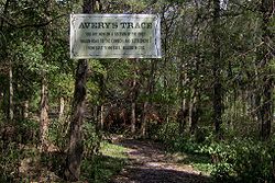 The first major road connecting the Upper Cumberland region with settlements to the east, known as Avery's Trace, was completed in 1788. The road, which connected Fort Southwest Point
with Nashville, passed a few hundred feet east of Bledsoe's Station. Guests at Bledsoe's Station in the 1790s included French botanist André Michaux
and Louis-Philippe, Duke of Orléans
and later king of France. General James Winchester
, who helped establish Cairo to the southwest and was later instrumental in the founding of Memphis
, purchased Bledsoe's Station in 1797. The following year, Winchester completed Cragfont near Bledsoe Creek about a mile to the west.
In 1807, a pioneer from North Carolina named Jeremiah Belote (d. 1822) purchased Bledsoe's Lick, and his descendants would retain possession of the property for several decades.
Following Winchester's death in 1826, his daughter, Almira Wynne, inherited what is now the Wynnewood State Historical Site. Wynnewood— the largest extant log structure in the state— was completed in 1830 and operated as an inn. During this period, the Winchester family also managed to change the name of Bledsoe's Lick to "Castalian Springs", the name being derived from the spring of mythological importance
near Delphi
in Greece. Castalian Springs thrived sporadically as a health resort until 1914. The Bledsoe's Station site was purchased by Sumner County in 1989.

Castalian Springs, Tennessee
Castalian Springs is an unincorporated community in Sumner County, Tennessee, United States. It is located along Tennessee State Route 25 about seven miles east of Gallatin, Tennessee. The area has its own post office. The Zip Code for Castalian Springs is 37031...
, in the southeastern United States. The fort was built by long hunter
Longhunter
A Longhunter was an 18th-century explorer and hunter who made expeditions into the American frontier wilderness for as much as six months at a time...
and Sumner County
Sumner County, Tennessee
Sumner County is a county located in the U.S. state of Tennessee. As of 2000, the population was 130,449. Its county seat is Gallatin, but its largest town is Hendersonville...
pioneer Isaac Bledsoe (c. 1735–1793) in the early 1780s to protect Upper Cumberland settlers and migrants from hostile Native American
Native Americans in the United States
Native Americans in the United States are the indigenous peoples in North America within the boundaries of the present-day continental United States, parts of Alaska, and the island state of Hawaii. They are composed of numerous, distinct tribes, states, and ethnic groups, many of which survive as...
attacks. While the fort is no longer standing, its location has been verified by archaeological excavations. The site is now part of Bledsoe's Fort Historical Park, a public park established in 1989 by Sumner County residents and Bledsoe's descendants.
Bledsoe's Station was one of a series of outposts built in the Upper Cumberland during the first major migration of Euro-American settlers into the Middle Tennessee area following the American Revolution
American Revolutionary War
The American Revolutionary War , the American War of Independence, or simply the Revolutionary War, began as a war between the Kingdom of Great Britain and thirteen British colonies in North America, and ended in a global war between several European great powers.The war was the result of the...
. The fort was a convenient stopover along Avery's Trace— the main road connecting East and Middle Tennessee at the time. The flood of settlers into the region brought inevitable conflict with the region's Native American inhabitants, and dozens of settlers were killed in the late 1780s and early 1790s. Isaac Bledsoe's brother Anthony (1733–1788) was killed in an ambush at the fort in 1788 and Isaac himself was killed while tending a field just outside the fort in 1793. The end of the Chickamauga Wars
Chickamauga wars
The Chickamauga Wars were a series of raids, campaigns, ambushes, minor skirmishes, and several full-scale frontier battles which were a continuation of the Cherokee struggle against encroachment by American frontiersmen from the former British colonies...
the following year ended much of the violence and reduced the fort's necessity.
Bledsoe's Fort Historical Park protects the fort's excavation site (an outline of the fort's walls can be discerned from former excavation trenches) as well as several historic structures, including the Nathaniel Parker Cabin and Hugh Rogan Cottage (both Parker and Rogan were compatriots of Bledsoe) and a pioneer cemetery with an obelisk dedicated to the Bledsoe brothers. The Cheskiki Indian Mounds and the Wynnewood State Historical Site
Wynnewood (Tennessee)
Wynnewood State Historic Area, also known as Castalian Springs, and located in Castalian Springs, Sumner County, Tennessee, includes the largest existing log structure in Tennessee. It is a National Historic Landmark....
are located immediately east of the park, and the Cragfont State Historical Site
Cragfont
Cragfont, located in Castalian Springs, Sumner County, Tennessee, was the home of James Winchester. Construction was started in 1798 and completed in 1802 by artisans from his home state of Maryland. It is listed with the National Register of Historic Places and is open to the public...
is located immediately to the west.
Geographical setting
Bledsoe's Station was located on a hill slope between Bledsoe Creek to the west and Bledsoe Lick Creek to the east. Both streams empty into the Old Hickory Lake impoundment of the Cumberland RiverCumberland River
The Cumberland River is a waterway in the Southern United States. It is long. It starts in Harlan County in far southeastern Kentucky between Pine and Cumberland mountains, flows through southern Kentucky, crosses into northern Tennessee, and then curves back up into western Kentucky before...
just over a mile to the south. The hill is relatively blunt and consists of open fields alternating with densely forested areas. The top of the hill is used as a flying zone for radio-controlled airplanes. The spring that furnished the minerals for Bledsoe's Lick flows at the base of the hill a few hundred yards east of the fort site.
Bledsoe's Fort Historical Park covers most of the hill between the Sumner County RC Flyers airfield and Rock Springs Road. Tennessee State Route 25 (Hartsville Pike) provides the park's southern boundary and main access. The park is roughly halfway between Hartsville
Hartsville, Tennessee
Hartsville is a town in Trousdale County, Tennessee, United States. It is the county seat of Trousdale County, with which it shares a consolidated city-county government...
to the east and Gallatin to the west, and lies approximately 35 miles (56.3 km) northeast of Nashville
Nashville, Tennessee
Nashville is the capital of the U.S. state of Tennessee and the county seat of Davidson County. It is located on the Cumberland River in Davidson County, in the north-central part of the state. The city is a center for the health care, publishing, banking and transportation industries, and is home...
.
Early exploration
Native Americans in the United States
Native Americans in the United States are the indigenous peoples in North America within the boundaries of the present-day continental United States, parts of Alaska, and the island state of Hawaii. They are composed of numerous, distinct tribes, states, and ethnic groups, many of which survive as...
hunters to the area. Native Americans were hunting around Bledsoe's Lick as early as 12,000 years ago during the Paleo-Indian period, and camped sporadically in the area throughout the Archaic (8000-1000 BC) and Woodland
Woodland period
The Woodland period of North American pre-Columbian cultures was from roughly 1000 BCE to 1000 CE in the eastern part of North America. The term "Woodland Period" was introduced in the 1930s as a generic header for prehistoric sites falling between the Archaic hunter-gatherers and the...
(1000 BC - 1000 AD) periods. During the Mississippian period
Mississippian culture
The Mississippian culture was a mound-building Native American culture that flourished in what is now the Midwestern, Eastern, and Southeastern United States from approximately 800 CE to 1500 CE, varying regionally....
(c. 1000–1450 AD), a substantial village had been established at the Castalian Springs Mound Site
Castalian Springs Mound Site
The Castalian Springs Mound Site is a Mississippian culture archaeological site located near the small unincorporated community of Castalian Springs in Sumner County, Tennessee. The site was first excavated in the 1890s and again as recently as the 2005 to 2011 archaeological field school led by...
, a few hundred yards from the mineral springs. The village covered 40 acre (0.1618744 km²) and contained at least 12 mounds. By the time the first Euro-American explorers arrived in the area in the mid-18th century, the Cherokee
Cherokee
The Cherokee are a Native American people historically settled in the Southeastern United States . Linguistically, they are part of the Iroquoian language family...
, Chickasaw
Chickasaw
The Chickasaw are Native American people originally from the region that would become the Southeastern United States...
, and Creek claimed the area as a hunting ground.
Among the first documented English explorers in the Upper Cumberland region were the long hunters, so-called because of the long duration of their hunting expeditions. The long hunters typically followed the Cumberland River and its headwaters from southwestern Virginia into Middle Tennessee. Expeditions led by Henry Scaggs
Henry Scaggs
Henry Scaggs was an American hunter, explorer and pioneer, active primarily on the frontiers of Tennessee and Kentucky during the latter half of the 18th century. His career as an explorer began as early as 1761 as one of the so-called long hunters— men who undertook lengthy hunting...
in 1765 and James Smith in 1766 passed through what is now Sumner County and hunted extensively in the Upper Cumberland region. In 1769, an expedition led by Kasper Mansker spent several months in the Upper Cumberland area, eventually sending two canoes full of furs downriver to Natchez, Mississippi
Natchez, Mississippi
Natchez is the county seat of Adams County, Mississippi, United States. With a total population of 18,464 , it is the largest community and the only incorporated municipality within Adams County...
. Mansker returned to the Upper Cumberland in 1771 with a larger group of hunters— among them Isaac Bledsoe— and collected several thousand skins. In 1772, Mansker and Bledsoe led a third expedition to the Upper Cumberland region. This group established a base camp along Station Camp Creek (giving the creek its name) a few miles to the west near Gallatin. It was during this third expedition that Bledsoe followed the ancient buffalo paths to the creek and salt lick that now bear his name, and where he would eventually construct his fort.
In the late 1770s, long hunter and explorer Thomas "Bigfoot" Spencer led a hunting expedition that camped near Bledsoe's Lick. Spencer remained throughout 1778, spending the winter in a hollowed-out sycamore
Sycamore
Sycamore is a name which is applied at various times and places to three very different types of trees, but with somewhat similar leaf forms....
tree just south of the mineral springs. Spencer spent much of the year building cabins in the area, believing (mistakenly) that if he constructed cabins on certain tracts of land, he could lay claim to these tracts.
Settlement and hostilities
Virginia
The Commonwealth of Virginia , is a U.S. state on the Atlantic Coast of the Southern United States. Virginia is nicknamed the "Old Dominion" and sometimes the "Mother of Presidents" after the eight U.S. presidents born there...
in the early 1730s. Anthony Bledsoe, the older of the two, served in the French and Indian War
French and Indian War
The French and Indian War is the common American name for the war between Great Britain and France in North America from 1754 to 1763. In 1756, the war erupted into the world-wide conflict known as the Seven Years' War and thus came to be regarded as the North American theater of that war...
and in various capacities with the Virginia militia. He commanded Fort Patrick Henry at Long Island of the Holston in 1776 and was elected to the Virginia House of Delegates the following year. Isaac Bledsoe also served in the French and Indian War, and following the long hunting excursions of the early 1770s, Bledsoe joined William Christian's
William Christian (Virginia)
William Christian was an "Indian fighter", Continental soldier, militiaman and politician from Virginia who served in the era of the American Revolution. He was a signatory to the Fincastle Resolutions and founder of Fort William...
1776 punitive expedition against the Cherokee. In 1779, North Carolina appointed Anthony Bledsoe to lead a surveying party to Middle Tennessee. Isaac Bledsoe followed in 1781.
Isaac Bledsoe probably began building Bledsoe's Station shortly after his arrival, although he didn't move his family into the fort until 1783. Around the time Bledsoe's Station was completed, Anthony Bledsoe completed a fort at Greenfield 2.5 miles (4 km) north of Bledsoe's Station. As settlers poured into the Upper Cumberland region, conflict with the region's Native American inhabitants intensified. The Chickamauga
Chickamauga
Chickamauga may refer to:* Chickamauga Indian* Chickamauga Wars , battles between Cherokee and Anglo-American pioneer settlers; also related to the American Revolutionary War* Chickamauga, Georgia...
s— a renegade branch of the Cherokee— had for the most part been at war with the United States since 1776, and opposed land concessions that would allow Euro-American settlers to move into the Middle Tennessee area permanently. In 1782, frontiersman Hugh Rogan (1747–1814) was nearly killed in an ambush in the vicinity of what is now Cragfont. A hunting party led by Thomas Spencer was attacked at Drake's Creek in 1784. Spencer survived, but was later killed in an ambush near Crab Orchard
Crab Orchard, Tennessee
Crab Orchard is a city in Cumberland County, Tennessee, United States. The population was 838 at the 2000 census.-Geography:Crab Orchard is located at . The town is situated atop the Cumberland Plateau in a gap amidst the Crab Orchard Mountains, a sub-range of the Cumberland Mountains...
. In 1786, Anthony Bledsoe wrote a letter to North Carolina governor Richard Caswell
Richard Caswell
Richard Caswell was the first and fifth governor of the U.S. State of North Carolina, serving from 1776 to 1780 and from 1784 to 1787....
reporting that 14 settlers had been killed that year and sought permission to attack the Chickamaugas. A schoolmaster named George Hamilton was shot and badly wounded at Bledsoe's Station in 1787. As attacks increased, Anthony Bledsoe moved his family from Greenfield to Bledsoe's Station, which afforded better protection, but in 1788 he was shot and mortally wounded when he accidentally stepped into a section of the fort vulnerable to hostile fire. During the engagement, Hugh Rogan— who was in the fort at the time— volunteered to try and sneak to a nearby fort to obtain means for making a fire and providing light by which the dying Bledsoe could draw up a will.
Conflict between the Chickamaugas and the Upper Cumberland settlers continued into the early 1790s. Ziegler's Fort (at what is now Bledsoe Creek State Park
Bledsoe Creek State Park
Bledsoe Creek State Park is a state park in Sumner County, Tennessee, in the southeastern United States. The park consists of managed by the Tennessee Department of Environment and Conservation. The park spans much of the west shore of the Bledsoe Creek embayment of Old Hickory Lake, an...
a few miles southwest of Bledsoe's Lick) was overrun in 1792, and Morgan's Station (northwest of Bledsoe's Lick) was nearly burned a few months later. In 1793, Isaac Bledsoe was shot and killed while walking through a field near Bledsoe's Station. The following year, a son of Anthony Bledsoe (named Anthony) and a nephew of Anthony and Isaac (also named Anthony) were both ambushed and killed near Rock Castle at what is now Hendersonville
Hendersonville, Tennessee
Hendersonville is a city in Sumner County, Tennessee, United States, on Old Hickory Lake. The population was 51,372 at the 2010 census. Hendersonville is part of the Nashville Metropolitan Statistical Area and is located 18 miles northeast of downtown Nashville. The city was settled around 1784 by...
. Thomas Bledsoe, another son of Anthony Bledsoe, was ambushed and killed a few months later. Hostilities between the settlers and the Chickamaugas finally subsided when the 1794 Treaty of Tellico brought an end to the Chickamauga Wars.
Later history
Fort Southwest Point
Fort Southwest Point was a federal frontier outpost at what is now Kingston, Tennessee, in the southeastern United States. Constructed in 1797 and garrisoned by federal soldiers until 1811, the fort served as a major point of interaction between the Cherokee and the United States government as...
with Nashville, passed a few hundred feet east of Bledsoe's Station. Guests at Bledsoe's Station in the 1790s included French botanist André Michaux
André Michaux
André Michaux was a French botanist and explorer.-Biography:Michaux was born in Satory, now part of Versailles, Yvelines. After the death of his wife within a year of their marriage he took up the study of botany and was a student of Bernard de Jussieu...
and Louis-Philippe, Duke of Orléans
Louis-Philippe of France
Louis Philippe I was King of the French from 1830 to 1848 in what was known as the July Monarchy. His father was a duke who supported the French Revolution but was nevertheless guillotined. Louis Philippe fled France as a young man and spent 21 years in exile, including considerable time in the...
and later king of France. General James Winchester
James Winchester
James Winchester was an officer in the American Revolutionary War and a brigadier general during the War of 1812. He commanded the American forces at the Battle of Frenchtown, which led to the Massacre of the River Raisin....
, who helped establish Cairo to the southwest and was later instrumental in the founding of Memphis
Memphis, Tennessee
Memphis is a city in the southwestern corner of the U.S. state of Tennessee, and the county seat of Shelby County. The city is located on the 4th Chickasaw Bluff, south of the confluence of the Wolf and Mississippi rivers....
, purchased Bledsoe's Station in 1797. The following year, Winchester completed Cragfont near Bledsoe Creek about a mile to the west.
In 1807, a pioneer from North Carolina named Jeremiah Belote (d. 1822) purchased Bledsoe's Lick, and his descendants would retain possession of the property for several decades.
Following Winchester's death in 1826, his daughter, Almira Wynne, inherited what is now the Wynnewood State Historical Site. Wynnewood— the largest extant log structure in the state— was completed in 1830 and operated as an inn. During this period, the Winchester family also managed to change the name of Bledsoe's Lick to "Castalian Springs", the name being derived from the spring of mythological importance
Castalian Spring
The Castalian Spring, in the ravine between the Phaedriades at Delphi, is where all visitors to Delphi — the contestants in the Pythian Games, and especially suppliants who came to consult the Delphic Oracle — stopped to wash their hair; and where Roman poets came to receive poetic...
near Delphi
Delphi
Delphi is both an archaeological site and a modern town in Greece on the south-western spur of Mount Parnassus in the valley of Phocis.In Greek mythology, Delphi was the site of the Delphic oracle, the most important oracle in the classical Greek world, and a major site for the worship of the god...
in Greece. Castalian Springs thrived sporadically as a health resort until 1914. The Bledsoe's Station site was purchased by Sumner County in 1989.
Bledsoe's Fort Historical Park
Bledsoe's Fort Historical Park consists of approximately 80 acre (0.3237488 km²), and includes the Bledsoe's Station site and several other features important to the early history of the Upper Cumberland region. The park is owned by Sumner County and maintained by the Bledsoe's Lick Historical Association. A short loop trail— part of which follows a section of Avery's Trace— provides access to the fort site and other features.Historical features at Bledsoe's Fort Historical Park
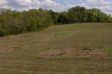
- Bledsoe's Station site — the site of Bledsoe's Station was excavated by Middle Tennessee State UniversityMiddle Tennessee State UniversityMiddle Tennessee State University, commonly abbreviated as MTSU, is a public university located in Murfreesboro, Tennessee, United States....
in the late 1990s. Excavators discovered several root cellars (indicating the presence of log cabins) and the fort's stockade. The excavation trench lines remain, and a small platform overlooks the site.
- Hugh Rogan Cottage — Hugh Rogan's stone cottage was built a few miles north of Bledsoe's Lick around 1800. The cottage's architecture was heavily influenced by folk traditions of Rogan's native Ireland, namely the low gabled roof and corresponding doors and windows. The cottage was dismantled and moved to the park in 1998.
- Nathaniel Parker Cabin — Nathaniel Parker's cabin is a typical pioneer log cabin, built in the 1780s. The cabin was originally located a few miles north of Bledsoe's Lick and later dismantled and moved to the park. Parker married Mary Ramsey Bledsoe— the widow of Anthony Bledsoe— in the 1790s and commanded the fort at Greenfield.
- Belote Cemetery — the Belote Cemetery (also called the "Pioneer Cemetery") is located along a section of Avery's Trace a few hundred yards southeast of the fort site and contains the graves of various early settlers in the Bledsoe's Lick area. The cemetery's most prominent feature is a 15 feet (4.6 m) obelisk erected by the Bledsoe family in 1908 as a monument to Isaac and Anthony Bledsoe.
- Long hunter camp — the long hunter camp is a demonstration area located along a spring near the ancient salt lick. MTSU has constructed a "lean-to" structure believed to be typical of shelters used at 18th-century long hunter base camps.
- Belote springhouse — the ruins of a springhouse used by the Belote family in the 19th century are located along a spring in the Bledsoe's Lick area, near the Long hunter camp.
- The Cavern of the Skulls — the Cavern of the Skulls is a cave located a few hundred feet east of the fort site. The cave's entrance, which is approximately 5 feet (1.5 m) x 10 feet (3 m), is closed to the public. 19th-century cave explorers reported the presence of human skulls in the cave, suggesting that the inhabitants of the Cheskiki Mound village may have used the cave to store "trophy" skulls. A ritual scene depicted on a [[shell gorget]] uncovered at the mound site lends some credence to this hypothesis.
Sources
- Sumner County Fact Book 2007–2008. The News Examiner & The Hendersonville Star News. 2007.
External links
- Archaeological Investigations at Bledsoe's Station, Middle Tennessee State University
- Anthony Bledsoe (1733-1788) in Tennessee Encyclopedia of History and Culture
- Isaac Bledsoe (1735-1793) in Tennessee Encyclopedia of History and Culture
- Frontier Stations in Tennessee Encyclopedia of History and Culture