
Bledsoe Creek State Park
Encyclopedia
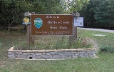
Bledsoe Creek State Park is a state park
in Sumner County, Tennessee
, in the southeastern United States. The park consists of 164 acre (0.66368504 km²) managed by the Tennessee Department of Environment and Conservation. The park spans much of the west shore of the Bledsoe Creek embayment of Old Hickory Lake
, an impoundment of the Cumberland River
created with the completion of Old Hickory Dam by the U.S. Army Corps of Engineers in 1954.
Bledsoe Creek State Park was developed as a recreational area by the Corps as part of its Old Hickory Dam project, and was designated a state park by the state of Tennessee in 1973. The park is primarily a campground and recreational boating and fishing area, although the park has developed several miles of hiking trails and provides environmental programs throughout the year. The park is located within a 5 miles (8 km) radius of the Wynnewood
and Cragfont
state historic sites, Bledsoe's Fort Historic Park
, a Mississippian
-period mound complex, and the Cairo Rosenwald School
, all of which attest to the area's pre-historic and historic importance to the Upper Cumberland region.
 The Cumberland River, which enters Tennessee from the mountains of Kentucky to the northeast, flows westward across Sumner County en route to the Nashville area. Old Hickory Lake, created in 1954 by the completion of Old Hickory Dam and Lock near Hendersonville
, spans a 97 miles (156.1 km) section of the river between the dam and Cordell Hull Dam near Carthage
. Approximately 30 miles (48.3 km) upstream from Old Hickory Dam, the Cumberland River absorbs Bledsoe Creek, which flows southward from its source on the northern Highland Rim
, forming an embayment that spans the lower 2 miles (3.2 km) of the creek. Bledsoe Creek State Park spans most of the northwest shore of this embayment.
Bledsoe Creek State Park is situated just off Tennessee State Route 25 (Hartsville Pike), roughly halfway between Gallatin
and Hartsville
, and 35 miles (56.3 km) northeast of Nashville. The park is located entirely in Sumner County. The park is managed by the Tennessee Department of Environment and Conservation
, which leases the land from the U.S. Army Corps of Engineers.
Bledsoe Creek State Park is located in the Central Basin
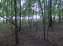
physiographic region. The park's terrain consists of low hills that give way to a flat shoreline. Approximately 68% of the park is forested and 12% is aquatic, with the remainder being open fields or developed land. Fauna include whitetail deer, wild turkey
, beaver
, bobcat
, fox
, and muskrat
. Bald eagle
s and golden eagle
s are occasionally spotted in winter.
 Native Americans
have been hunting and camping in the Sumner County area for over 12,000 years. Artifacts dating to the Paleo-Indian and Archaic periods have been found in the park's vicinity, and a substantial Mississippian
-period (c. 1000-1500 A.D.) village was located at nearby Castalian Springs. The Sumner region was probably part of Shawnee
territory throughout the 17th century, although they had been expelled by the Cherokee
and Chickasaw
by around 1700.
The first major Euro-American expeditions into Sumner County were led by long hunters
, so called because the relatively long duration of their hunting expeditions. Long hunter Henry Scaggs
was hunting along the Cumberland as early as 1765, and James Smith led the first major long hunting expedition into the Cumberland region in 1766. Between 1769 and 1772, a large group of long hunters were active in the Upper Cumberland region, among them Kasper Mansker and Isaac Bledsoe (c. 1735-1794). At one point the expedition established a base camp along Station Camp Creek (giving the creek its name) a few miles west of modern Gallatin. In 1772, Bledsoe discovered the creek and salt lick that now bear his name (the lick was near modern Castalian Springs). In the early 1780s, at the end of the American Revolution
, Bledsoe returned to the salt lick and built Bledsoe's Station
, one of a series of small forts erected to protect early Middle Tennessee settlers from hostile Native Americans.
Hostility between Native Americans and Euro-American settlers increased throughout the 1780s as Euro-American settlers flooded into the Middle Tennessee region. Colonel Anthony Bledsoe (1733–1787), an older brother of Isaac, reported to the governor of North Carolina that 14 settlers had been killed in 1786 alone. Anthony Bledsoe himself was killed in an ambush at Bledsoe's Station the following year. In 1791, Jacob Ziegler built Ziegler's Fort near what is now Bledsoe Creek State Park. The fort was overrun within a few months, however, after a day-long attack that killed Ziegler and several others. The threat of Native American attacks finally subsided in 1794 with the end of the Chickamauga Wars
.
After the State of Tennessee was created in 1796, the state's legislature passed a resolution calling for the creation of a county seat for Sumner County. The new city was to be named "Ca Ira" after a song made popular by the French Revolution
. Bickering among the county commissioners delayed the establishment of the city for several years, and they eventually decided to place the seat in Gallatin. In 1799, General James Winchester
(1752–1826) and William Cage, Jr. purchased 150 acre (0.607029 km²) immediately south of Ziegler's Fort at the confluence of Bledsoe's Creek and the Cumberland River for the establishment of a town. The new town's name, "Cairo", was either a corruption of Ca Ira— the name chosen for the county seat— or was selected by Winchester, a fan of ancient history (Winchester was later instrumental in the establishment of Memphis
, also named after an Egyptian city).
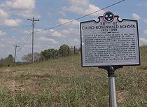
Cairo quickly became one of the key river trading hubs in the Upper Cumberland region. Winchester and Cage established a mercantile business and a successful flatboat
trade between Cairo and New Orleans
. By 1812, the city had its own cotton mill, woolen mill, saw mill, gristmill
, still house, and tavern. The death of Winchester in 1826 and the improvement and shift of the main road between Knoxville
and Nashville away from Sumner, however, led to Cairo's eventual decline. In 1923, the Cairo community took advantage of Rosenwald Fund
s to establish a school for African-American children, which operated until 1959. The Cairo Rosenwald School
, located just north of Bledsoe Creek State Park, was placed on the National Register of Historic Places
in 1996.
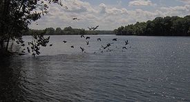
 Bledsoe Creek State Park maintains a 72-site campground, two boat ramps, two picnic pavilions, and various athletic courts. Old Hickory Lake is stocked with bluegill, crappie, catfish, and bass for recreational fishing. The park also has a designated wildlife observation area and offers various environmental programs.
Over 6 miles (9.7 km) of hiking trails meander through the forest and along the lakeshore of the park. The Shoreline Trail is 2.5 miles (4 km) long, mostly following the park's lakeshore and wildlife observation area. The High Ridge Trail is 3 miles (4.8 km) long and follows the ridgecrest near the park's northern boundary. The Birdsong Trail is a 0.75 miles (1.2 km) paved trail that winds through the woods near the visitor center.
Since 2003, park officials and volunteers have been working to catalogue the various plant and animal species found within the park. Funds from Tennessee's Iris License Plate project have helped with revegetation and tree planting efforts.
State park
State parks are parks or other protected areas managed at the federated state level within those nations which use "state" as a political subdivision. State parks are typically established by a state to preserve a location on account of its natural beauty, historic interest, or recreational...
in Sumner County, Tennessee
Sumner County, Tennessee
Sumner County is a county located in the U.S. state of Tennessee. As of 2000, the population was 130,449. Its county seat is Gallatin, but its largest town is Hendersonville...
, in the southeastern United States. The park consists of 164 acre (0.66368504 km²) managed by the Tennessee Department of Environment and Conservation. The park spans much of the west shore of the Bledsoe Creek embayment of Old Hickory Lake
Old Hickory Lake
Old Hickory Lake is a reservoir in north central Tennessee. It is formed by the Old Hickory Lock and Dam , located on the Cumberland River at mile 216.2 in Sumner and Davidson Counties, approximately upstream from Nashville...
, an impoundment of the Cumberland River
Cumberland River
The Cumberland River is a waterway in the Southern United States. It is long. It starts in Harlan County in far southeastern Kentucky between Pine and Cumberland mountains, flows through southern Kentucky, crosses into northern Tennessee, and then curves back up into western Kentucky before...
created with the completion of Old Hickory Dam by the U.S. Army Corps of Engineers in 1954.
Bledsoe Creek State Park was developed as a recreational area by the Corps as part of its Old Hickory Dam project, and was designated a state park by the state of Tennessee in 1973. The park is primarily a campground and recreational boating and fishing area, although the park has developed several miles of hiking trails and provides environmental programs throughout the year. The park is located within a 5 miles (8 km) radius of the Wynnewood
Wynnewood (Tennessee)
Wynnewood State Historic Area, also known as Castalian Springs, and located in Castalian Springs, Sumner County, Tennessee, includes the largest existing log structure in Tennessee. It is a National Historic Landmark....
and Cragfont
Cragfont
Cragfont, located in Castalian Springs, Sumner County, Tennessee, was the home of James Winchester. Construction was started in 1798 and completed in 1802 by artisans from his home state of Maryland. It is listed with the National Register of Historic Places and is open to the public...
state historic sites, Bledsoe's Fort Historic Park
Bledsoe's Station
Bledsoe's Station was an 18th-century frontier fort located in what is now Castalian Springs, Tennessee, in the southeastern United States. The fort was built by long hunter and Sumner County pioneer Isaac Bledsoe in the early 1780s to protect Upper Cumberland settlers and migrants from hostile...
, a Mississippian
Mississippian culture
The Mississippian culture was a mound-building Native American culture that flourished in what is now the Midwestern, Eastern, and Southeastern United States from approximately 800 CE to 1500 CE, varying regionally....
-period mound complex, and the Cairo Rosenwald School
Cairo Rosenwald School
Cairo Rosenwald School was a school for African-Americans located in Cairo, Sumner County, Tennessee. The school, completed in 1923, followed the architectural style of the Rosenwald School design for a one-teacher African-American school. Its construction was funded by the African-American...
, all of which attest to the area's pre-historic and historic importance to the Upper Cumberland region.
Geographical and natural setting
Hendersonville, Tennessee
Hendersonville is a city in Sumner County, Tennessee, United States, on Old Hickory Lake. The population was 51,372 at the 2010 census. Hendersonville is part of the Nashville Metropolitan Statistical Area and is located 18 miles northeast of downtown Nashville. The city was settled around 1784 by...
, spans a 97 miles (156.1 km) section of the river between the dam and Cordell Hull Dam near Carthage
Carthage, Tennessee
Carthage is a town in Smith County, Tennessee, United States, and is part of the Nashville Metropolitan Statistical Area. The population was 2,251 at the 2000 census. It is the county seat of Smith County, and perhaps best known as the hometown of former Vice President Al Gore, and his father,...
. Approximately 30 miles (48.3 km) upstream from Old Hickory Dam, the Cumberland River absorbs Bledsoe Creek, which flows southward from its source on the northern Highland Rim
Highland Rim
The Highland Rim is a geographic term for the area in Tennessee surrounding the Central Basin. Nashville is largely surrounded by higher terrain in all directions....
, forming an embayment that spans the lower 2 miles (3.2 km) of the creek. Bledsoe Creek State Park spans most of the northwest shore of this embayment.
Bledsoe Creek State Park is situated just off Tennessee State Route 25 (Hartsville Pike), roughly halfway between Gallatin
Gallatin, Tennessee
Gallatin is a city in and the county seat of Sumner County, Tennessee, United States, along a navigable tributary of the Cumberland River. The population was 23,230 at the 2000 census. Named for U.S...
and Hartsville
Hartsville, Tennessee
Hartsville is a town in Trousdale County, Tennessee, United States. It is the county seat of Trousdale County, with which it shares a consolidated city-county government...
, and 35 miles (56.3 km) northeast of Nashville. The park is located entirely in Sumner County. The park is managed by the Tennessee Department of Environment and Conservation
Tennessee Department of Environment and Conservation
The Tennessee Department of Environment and Conservation is a Cabinet-level agency within the government of the U.S. state of Tennessee, headed by the Tennessee Commissioner of Environment and Conservation....
, which leases the land from the U.S. Army Corps of Engineers.
Bledsoe Creek State Park is located in the Central Basin
Nashville Basin
The Nashville Basin, also known as the Central Basin, is a term often used to describe the area surrounding Nashville, Tennessee. The Central Basin was caused by an uplifting known as the Nashville Dome. The Nashville Dome is evidenced by the underlying rock strata that all dip downwards away from...
physiographic region. The park's terrain consists of low hills that give way to a flat shoreline. Approximately 68% of the park is forested and 12% is aquatic, with the remainder being open fields or developed land. Fauna include whitetail deer, wild turkey
Wild Turkey
The Wild Turkey is native to North America and is the heaviest member of the Galliformes. It is the same species as the domestic turkey, which derives from the South Mexican subspecies of wild turkey .Adult wild turkeys have long reddish-yellow to grayish-green...
, beaver
Beaver
The beaver is a primarily nocturnal, large, semi-aquatic rodent. Castor includes two extant species, North American Beaver and Eurasian Beaver . Beavers are known for building dams, canals, and lodges . They are the second-largest rodent in the world...
, bobcat
Bobcat
The bobcat is a North American mammal of the cat family Felidae, appearing during the Irvingtonian stage of around 1.8 million years ago . With twelve recognized subspecies, it ranges from southern Canada to northern Mexico, including most of the continental United States...
, fox
Fox
Fox is a common name for many species of omnivorous mammals belonging to the Canidae family. Foxes are small to medium-sized canids , characterized by possessing a long narrow snout, and a bushy tail .Members of about 37 species are referred to as foxes, of which only 12 species actually belong to...
, and muskrat
Muskrat
The muskrat , the only species in genus Ondatra, is a medium-sized semi-aquatic rodent native to North America, and introduced in parts of Europe, Asia, and South America. The muskrat is found in wetlands and is a very successful animal over a wide range of climates and habitats...
. Bald eagle
Bald Eagle
The Bald Eagle is a bird of prey found in North America. It is the national bird and symbol of the United States of America. This sea eagle has two known sub-species and forms a species pair with the White-tailed Eagle...
s and golden eagle
Golden Eagle
The Golden Eagle is one of the best known birds of prey in the Northern Hemisphere. Like all eagles, it belongs to the family Accipitridae. Once widespread across the Holarctic, it has disappeared from many of the more heavily populated areas...
s are occasionally spotted in winter.
History
Native Americans in the United States
Native Americans in the United States are the indigenous peoples in North America within the boundaries of the present-day continental United States, parts of Alaska, and the island state of Hawaii. They are composed of numerous, distinct tribes, states, and ethnic groups, many of which survive as...
have been hunting and camping in the Sumner County area for over 12,000 years. Artifacts dating to the Paleo-Indian and Archaic periods have been found in the park's vicinity, and a substantial Mississippian
Mississippian culture
The Mississippian culture was a mound-building Native American culture that flourished in what is now the Midwestern, Eastern, and Southeastern United States from approximately 800 CE to 1500 CE, varying regionally....
-period (c. 1000-1500 A.D.) village was located at nearby Castalian Springs. The Sumner region was probably part of Shawnee
Shawnee
The Shawnee, Shaawanwaki, Shaawanooki and Shaawanowi lenaweeki, are an Algonquian-speaking people native to North America. Historically they inhabited the areas of Ohio, Virginia, West Virginia, Western Maryland, Kentucky, Indiana, and Pennsylvania...
territory throughout the 17th century, although they had been expelled by the Cherokee
Cherokee
The Cherokee are a Native American people historically settled in the Southeastern United States . Linguistically, they are part of the Iroquoian language family...
and Chickasaw
Chickasaw
The Chickasaw are Native American people originally from the region that would become the Southeastern United States...
by around 1700.
The first major Euro-American expeditions into Sumner County were led by long hunters
Longhunter
A Longhunter was an 18th-century explorer and hunter who made expeditions into the American frontier wilderness for as much as six months at a time...
, so called because the relatively long duration of their hunting expeditions. Long hunter Henry Scaggs
Henry Scaggs
Henry Scaggs was an American hunter, explorer and pioneer, active primarily on the frontiers of Tennessee and Kentucky during the latter half of the 18th century. His career as an explorer began as early as 1761 as one of the so-called long hunters— men who undertook lengthy hunting...
was hunting along the Cumberland as early as 1765, and James Smith led the first major long hunting expedition into the Cumberland region in 1766. Between 1769 and 1772, a large group of long hunters were active in the Upper Cumberland region, among them Kasper Mansker and Isaac Bledsoe (c. 1735-1794). At one point the expedition established a base camp along Station Camp Creek (giving the creek its name) a few miles west of modern Gallatin. In 1772, Bledsoe discovered the creek and salt lick that now bear his name (the lick was near modern Castalian Springs). In the early 1780s, at the end of the American Revolution
American Revolutionary War
The American Revolutionary War , the American War of Independence, or simply the Revolutionary War, began as a war between the Kingdom of Great Britain and thirteen British colonies in North America, and ended in a global war between several European great powers.The war was the result of the...
, Bledsoe returned to the salt lick and built Bledsoe's Station
Bledsoe's Station
Bledsoe's Station was an 18th-century frontier fort located in what is now Castalian Springs, Tennessee, in the southeastern United States. The fort was built by long hunter and Sumner County pioneer Isaac Bledsoe in the early 1780s to protect Upper Cumberland settlers and migrants from hostile...
, one of a series of small forts erected to protect early Middle Tennessee settlers from hostile Native Americans.
Hostility between Native Americans and Euro-American settlers increased throughout the 1780s as Euro-American settlers flooded into the Middle Tennessee region. Colonel Anthony Bledsoe (1733–1787), an older brother of Isaac, reported to the governor of North Carolina that 14 settlers had been killed in 1786 alone. Anthony Bledsoe himself was killed in an ambush at Bledsoe's Station the following year. In 1791, Jacob Ziegler built Ziegler's Fort near what is now Bledsoe Creek State Park. The fort was overrun within a few months, however, after a day-long attack that killed Ziegler and several others. The threat of Native American attacks finally subsided in 1794 with the end of the Chickamauga Wars
Chickamauga wars
The Chickamauga Wars were a series of raids, campaigns, ambushes, minor skirmishes, and several full-scale frontier battles which were a continuation of the Cherokee struggle against encroachment by American frontiersmen from the former British colonies...
.
After the State of Tennessee was created in 1796, the state's legislature passed a resolution calling for the creation of a county seat for Sumner County. The new city was to be named "Ca Ira" after a song made popular by the French Revolution
Ah! ça ira
"Ah ! ça ira" is an emblematic song of the French Revolution, first heard in May 1790. It underwent several changes in wording, all of which used the title words as part of the refrain.-Original version:...
. Bickering among the county commissioners delayed the establishment of the city for several years, and they eventually decided to place the seat in Gallatin. In 1799, General James Winchester
James Winchester
James Winchester was an officer in the American Revolutionary War and a brigadier general during the War of 1812. He commanded the American forces at the Battle of Frenchtown, which led to the Massacre of the River Raisin....
(1752–1826) and William Cage, Jr. purchased 150 acre (0.607029 km²) immediately south of Ziegler's Fort at the confluence of Bledsoe's Creek and the Cumberland River for the establishment of a town. The new town's name, "Cairo", was either a corruption of Ca Ira— the name chosen for the county seat— or was selected by Winchester, a fan of ancient history (Winchester was later instrumental in the establishment of Memphis
Memphis, Tennessee
Memphis is a city in the southwestern corner of the U.S. state of Tennessee, and the county seat of Shelby County. The city is located on the 4th Chickasaw Bluff, south of the confluence of the Wolf and Mississippi rivers....
, also named after an Egyptian city).
Cairo quickly became one of the key river trading hubs in the Upper Cumberland region. Winchester and Cage established a mercantile business and a successful flatboat
Flatboat
Fil1800flatboat.jpgA flatboat is a rectangular flat-bottomed boat with Fil1800flatboat.jpgA flatboat is a rectangular flat-bottomed boat with Fil1800flatboat.jpgA flatboat is a rectangular flat-bottomed boat with (mostlyNOTE: "(parenthesized)" wordings in the quote below are notes added to...
trade between Cairo and New Orleans
New Orleans, Louisiana
New Orleans is a major United States port and the largest city and metropolitan area in the state of Louisiana. The New Orleans metropolitan area has a population of 1,235,650 as of 2009, the 46th largest in the USA. The New Orleans – Metairie – Bogalusa combined statistical area has a population...
. By 1812, the city had its own cotton mill, woolen mill, saw mill, gristmill
Gristmill
The terms gristmill or grist mill can refer either to a building in which grain is ground into flour, or to the grinding mechanism itself.- Early history :...
, still house, and tavern. The death of Winchester in 1826 and the improvement and shift of the main road between Knoxville
Knoxville, Tennessee
Founded in 1786, Knoxville is the third-largest city in the U.S. state of Tennessee, U.S.A., behind Memphis and Nashville, and is the county seat of Knox County. It is the largest city in East Tennessee, and the second-largest city in the Appalachia region...
and Nashville away from Sumner, however, led to Cairo's eventual decline. In 1923, the Cairo community took advantage of Rosenwald Fund
Rosenwald Fund
The Rosenwald Fund was established in 1917 by Julius Rosenwald and his family for "the well-being of mankind."...
s to establish a school for African-American children, which operated until 1959. The Cairo Rosenwald School
Cairo Rosenwald School
Cairo Rosenwald School was a school for African-Americans located in Cairo, Sumner County, Tennessee. The school, completed in 1923, followed the architectural style of the Rosenwald School design for a one-teacher African-American school. Its construction was funded by the African-American...
, located just north of Bledsoe Creek State Park, was placed on the National Register of Historic Places
National Register of Historic Places
The National Register of Historic Places is the United States government's official list of districts, sites, buildings, structures, and objects deemed worthy of preservation...
in 1996.
The park today
Over 6 miles (9.7 km) of hiking trails meander through the forest and along the lakeshore of the park. The Shoreline Trail is 2.5 miles (4 km) long, mostly following the park's lakeshore and wildlife observation area. The High Ridge Trail is 3 miles (4.8 km) long and follows the ridgecrest near the park's northern boundary. The Birdsong Trail is a 0.75 miles (1.2 km) paved trail that winds through the woods near the visitor center.
Since 2003, park officials and volunteers have been working to catalogue the various plant and animal species found within the park. Funds from Tennessee's Iris License Plate project have helped with revegetation and tree planting efforts.
External links
- Bledsoe Creek State Park — official site