

Biffeche
Encyclopedia
Senegal
Senegal , officially the Republic of Senegal , is a country in western Africa. It owes its name to the Sénégal River that borders it to the east and north...
centred on the town of Savoigne, some 20 miles north-east of the major coastal city of Saint-Louis
Saint-Louis, Senegal
Saint-Louis, or Ndar as it is called in Wolof, is the capital of Senegal's Saint-Louis Region. Located in the northwest of Senegal, near the mouth of the Senegal River, and 320 km north of Senegal's capital city Dakar, it has a population officially estimated at 176,000 in 2005. Saint-Louis...
.
Low-lying and largely flat, the region has Fula
Fula people
Fula people or Fulani or Fulbe are an ethnic group spread over many countries, predominantly in West Africa, but found also in Central Africa and Sudanese North Africa...
, Serer-Ndut
Serer-Ndut
The Serer-Ndut also spelt are an ethnic group in Senegal numbering 38600They are part of the Serer people who collectively make up the third largest ethnic group in Senegal...
, Wolof
Wolof people
The Wolof are an ethnic group found in Senegal, The Gambia, and Mauritania.In Senegal, the Wolof form an ethnic plurality with about 43.3% of the population are Wolofs...
and Moor
Moors
The description Moors has referred to several historic and modern populations of the Maghreb region who are predominately of Berber and Arab descent. They came to conquer and rule the Iberian Peninsula for nearly 800 years. At that time they were Muslim, although earlier the people had followed...
ethnic groups engaged in pasturing animals (mainly the Fulas) and irrigation-based agriculture. Savoigne is the region's largest town, twinned with La Ferté Macé; its SOCAS tomato-paste factory imports and dilutes tomato paste for re-shipment within Senegal. The population is primarily Muslim
Muslim
A Muslim, also spelled Moslem, is an adherent of Islam, a monotheistic, Abrahamic religion based on the Quran, which Muslims consider the verbatim word of God as revealed to prophet Muhammad. "Muslim" is the Arabic term for "submitter" .Muslims believe that God is one and incomparable...
, but also contains Catholics and animists
African Traditional Religion
The traditional religions indigenous to Africa have, for most of their existence, been orally rather than scripturally transmitted. They are generally associated with animism. Most have ethno-based creations stories...
. The Djoudj National Bird Sanctuary
Djoudj National Bird Sanctuary
The Djoudj National Bird Sanctuary lies on the southeast bank of the River Senegal in Senegal, in northern Biffeche, north east of St-Louis. It provides a range of wetland habitats which prove very popular with migrating birds, many of which have just crossed the Sahara. Of almost 400 species of...
is located to the north.
Early European accounts used the word for a different location, describing a medium-sized island (Isle de Bifeche) in the delta of the Senegal River
Sénégal River
The Sénégal River is a long river in West Africa that forms the border between Senegal and Mauritania.The Sénégal's headwaters are the Semefé and Bafing rivers which both originate in Guinea; they form a small part of the Guinean-Malian border before coming together at Bafoulabé in Mali...
in West Africa
West Africa
West Africa or Western Africa is the westernmost region of the African continent. Geopolitically, the UN definition of Western Africa includes the following 16 countries and an area of approximately 5 million square km:-Flags of West Africa:...
, some two miles upstream from the island of N'Dar on which Saint-Louis was founded. The Penny Cyclopædia of the Society for the Diffusion of Useful Knowledge described the island in 1843 as being "entirely covered with wood, and in the wet season a great portion of them is laid under water." http://books.google.com/books?ie=UTF-8&hl=en&vid=0djgIW4z6KSBHnBRiUG&id=FtYtp9FJcuYC&pg=PA231&lpg=PA231&dq=Bifeche&vq=Bifeche&prev=http://books.google.com/books%3Fq%3DBifeche
Currently, the river marks this section of the border between Mauritania
Mauritania
Mauritania is a country in the Maghreb and West Africa. It is bordered by the Atlantic Ocean in the west, by Western Sahara in the north, by Algeria in the northeast, by Mali in the east and southeast, and by Senegal in the southwest...
and Senegal
Senegal
Senegal , officially the Republic of Senegal , is a country in western Africa. It owes its name to the Sénégal River that borders it to the east and north...
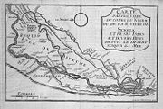
. The island can perhaps most easily be seen on the map http://www.au-senegal.com/decouvrir_en/cart_stlouis.htm
with one of its main towns Maka http://maps.google.com/maps?ll=15.9833,-16.5000&spn=0.1,0.1&t=k&hl=en clearly marked. A contemporary map can be found at
http://senegalmaur.ifrance.com/st-louis-com-traite.html - this map shows N'Dar under its older French name of
Isle St. Louis and the Pointe de isle de Bifeche is also visible. On the island is written Emboulan
which appears to be a European variant of a local town name MBoubene. It can also be just seen at the extreme top of Senegal in 1753.
In the 17th century a chief known as the Petit Brak
Brak (African kings)
Brak was the title of the kings of the kingdoms of Waalo and Biffeche on the Senegal River in Senegal and Mauritania in West Africa until the 19th century. The main Brak was the king of the Kingdom of Waalo with capital at Diourbel north of the river, and later at Nder on the west shore of Lac...
or Little King ruled over a region known variously as Biffeche or Gangueul with capital at Maka. The Grand Brak or Big King ruled the kingdom of Waalo
Waalo
The Kingdom of Waalo was a kingdom on the lower Senegal River in West Africa, in what are now Senegal and Mauritania. It included parts of the valley proper and areas north and south, extending to the Atlantic Ocean...
, whose capital was originally at Diourbel
Diourbel
Diourbel is a town in Senegal lying east of Thiès. It is known for its mosque and local groundnut industry. It is the capital of the Diourbel Region. Estimated population 2007: 100,445- Transport :...
. The area was nearly depopulated by repeated slaving raids by Moors from the north. At times, the Petit Brak was tributary to Waalo, at other times allied with Bethio
Bethio
The Principality of Bethio was a small monarchy located for centuries along the lower Senegal River valley, on the border between modern Mauritania and Senegal, in the northeast of Biffeche. In the 18th century it was also called the "Royaume d'Oral"...
. In the 1720s, the Brak of Waalo was Erim M'Bagnick and Béquio Malicouri, king of the Royaume d'Oral (Bethio), was his vassal.
General
- Barry, Boubacar. Le royaume du Waalo - Le Senegal avant la conquete. Karthala, 1985.
- Becker, Charles and Martin, Victor. Journal Historique et Suitte du Journal Historique (1729-1731) 39.2 (1977): 223-289. http://tekrur-ucad.refer.sn/IMG/pdf/JOURHIST1729-1731global.pdf
- Cultru, Prosper. Premier voyage du Sieur de la Courbe.... Paris: Larose, 1913.
- Encylopedie, dictionnaire raisonné des sciences, des arts et des métiers, par une société de gens de lettres, mis en ordre et publié par Mr. * * *, tome quinzieme. Neufchastel, France: Samuel Faulche, 1765. Facsimile page
- Knight, Charles. The Penny Cyclopædia of the Society for the Diffusion of Useful Knowledge, Vol. XXI. London, 1843: 231. Public domain copy
- Labat, Jean-Baptiste. Nouvelle Relation de l’Afrique occidentale. Paris: Cavelier, 1727. t. 2, p. 174.
- Thésée, Françoise. Actes du colloque de Nantes, tome I. 1988. 223-245. http://www.ankhonline.com/population_afrique.htm.
- Thilmans, Guy. Bull. Les planches sénégalaises et mauritaniennes des “Atlas Vingboons” , G. IFANInstitut Fondamental d'Afrique NoireIFAN is a cultural and scientific institute in the nations of the former French West Africa...
, B. t. 37.1 (1975): 106-109.
Historical maps
- Cours de la rivière de Sanaga ou Sénégal depuis son embouchure jusqu'à l'île de Bilbas / Suite du cours de la rivière de Sénégal depuis l'isle de Bilbas jusqu'au sault du Rocherde Govina / levé par un ingénieur francois, 1718. Online at BNF
- Carte de la rivière du Sénégal depuis la Barre jusqu'au Panier Foule des petites rivières et marigots qui en dérivent avec les noms des villages qui sont au bord, fait au Sénégal, 1720. Online at BNF
- Anville, Jean-Baptiste Bourguignon, Carte manuscrite de la côte d'Afrique aux environs de Gorée et de la rivière du Sénégal depuis Cagneux jusqu'à son embouchure. 1724. Online at BNF