
Berowra, New South Wales
Encyclopedia
Berowra is a suburb
of northern Sydney
, in the state of New South Wales
, Australia
. Berowra is located 38 kilometres north of the Sydney central business district
, in the local government area of Hornsby Shire
. Berowra is south-east of the suburbs of Berowra Heights
and east of Berowra Waters
.
, Pacific Highway
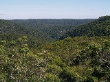
and main northern rail line. Berowra Valley Bushland Park sits to the west and to the north is the Muogamarra Nature Reserve
. Cowan Creek is located to the east. Berowra is 227 meters above sea level.
heading north or south and is approximately 15 minutes drive from the major regional shopping centre of Hornsby, New South Wales
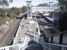
. The Berowra railway station is serviced by trains from both the North Shore Line and the Newcastle and Central Coast railway lines providing regular services to Sydney and the Central Coast / Newcastle
areas.
extended, so that a station was opened at Berowra in 1887. He also supported the building of a post office in 1900 and a road to Berowra Waters which opened in 1902. Mary Wall was granted 60 acres (242,811.6 m²) of land near Goodwyn Road off the Pacific Highway in 1887. Part of her grant meant she had to be there once a week and so she would walk at night through the bush from Surry Hills
and tend to her farm.
The area grew when the Pacific Highway and railway were built and settlers loved the fishing and surrounding bush. Mainly living in tents, the original settlers lived a tough existence and helped everyone. The first school was set up in Mary Wall's house before it was moved to what is now the Old District Hall at the roundabout, on the corner of Berowra Waters Road and Crowley Road.
Of the 1,496 dwellings in Berowra, 85% are freestanding houses with the remainder consisting of townhouses or units, according to the 2001 census . At the time of the 2001 census, 99 people stated they lived in caravans. It is likely these would have been residents of the now-closed La Mancha Caravan Park located on the Pacific Highway and slated for redevelopment as medium density housing. The median weekly household income is $1,200 - $1,499 and the mean household size consists of 3.1 individuals.
Suburb
The word suburb mostly refers to a residential area, either existing as part of a city or as a separate residential community within commuting distance of a city . Some suburbs have a degree of administrative autonomy, and most have lower population density than inner city neighborhoods...
of northern Sydney
Sydney
Sydney is the most populous city in Australia and the state capital of New South Wales. Sydney is located on Australia's south-east coast of the Tasman Sea. As of June 2010, the greater metropolitan area had an approximate population of 4.6 million people...
, in the state of New South Wales
New South Wales
New South Wales is a state of :Australia, located in the east of the country. It is bordered by Queensland, Victoria and South Australia to the north, south and west respectively. To the east, the state is bordered by the Tasman Sea, which forms part of the Pacific Ocean. New South Wales...
, Australia
Australia
Australia , officially the Commonwealth of Australia, is a country in the Southern Hemisphere comprising the mainland of the Australian continent, the island of Tasmania, and numerous smaller islands in the Indian and Pacific Oceans. It is the world's sixth-largest country by total area...
. Berowra is located 38 kilometres north of the Sydney central business district
Sydney central business district
The Sydney central business district is the main commercial centre of Sydney, New South Wales, Australia. It extends southwards for about 3 kilometres from Sydney Cove, the point of first European settlement. Its north–south axis runs from Circular Quay in the north to Central railway station in...
, in the local government area of Hornsby Shire
Hornsby Shire
Hornsby Shire is a Local Government Area in the Northern region of Sydney, Australia. The Shire stretches from the suburb of Eastwood in the south to the Hawkesbury River town of Wisemans Ferry, some to the north...
. Berowra is south-east of the suburbs of Berowra Heights
Berowra Heights, New South Wales
Berowra Heights is a suburb of northern Sydney, in the state of New South Wales, Australia. Berowra Heights is located 39 kilometres north of the Sydney central business district, in the local government area of Hornsby Shire and is part of the North Shore region...
and east of Berowra Waters
Berowra Waters, New South Wales
Berowra Waters is a suburb of northern Sydney, in the state of New South Wales, Australia. Berowra is located 40 kilometres north of the Sydney central business district, in the local government area of Hornsby Shire and is part of the North Shore region...
.
Location
Berowra is bounded to the east by the F3 Sydney-Newcastle FreewaySydney-Newcastle Freeway
The Sydney-Newcastle Freeway is a stretch of motorway linking Sydney to the Central Coast, Newcastle and Hunter regions of New South Wales. It is part of the AusLink road corridor between Sydney and Brisbane, carrying the route designation....
, Pacific Highway
Pacific Highway (Australia)
The Pacific Highway is a major transport route along part of the east coast of Australia and is part of Australia's national route 1.It is 960 km long and links Sydney, the capital of New South Wales, to Brisbane, the capital of Queensland, along the coast, via Gosford, Newcastle, Taree, Port...
and main northern rail line. Berowra Valley Bushland Park sits to the west and to the north is the Muogamarra Nature Reserve
Muogamarra Nature Reserve
Muogamarra is a nature reserve New South Wales , on the northern edge of Sydney. It lies between the outer Sydney suburb of Cowan to the south, and the Hawkesbury River to the north. It is closed to the public for most of the year, but opens for 6 weekends each year in spring, when there are...
. Cowan Creek is located to the east. Berowra is 227 meters above sea level.
Commercial area
Berowra is largely residential with a small retail precinct lining the Pacific Highway near the train station. In May 2007 a new shopping complex opened on Turner Road in Berowra Heights. Leading up to the opening, the Berowra & District Community raised over $750,000 in BSX listed shares to buy a franchise of the Bendigo Bank. The Community Bank became one of the first to open its doors in the new complex. This was a landmark development for the future prospects of the area as the last Bank in the area closed its doors in 1996.Transport
By road, Berowra has access to the F3 Sydney-Newcastle FreewaySydney-Newcastle Freeway
The Sydney-Newcastle Freeway is a stretch of motorway linking Sydney to the Central Coast, Newcastle and Hunter regions of New South Wales. It is part of the AusLink road corridor between Sydney and Brisbane, carrying the route designation....
heading north or south and is approximately 15 minutes drive from the major regional shopping centre of Hornsby, New South Wales
Hornsby, New South Wales
* Highest Maximum Temperature: 42 °C* Lowest Maximum Temperature: 4.9 °C* Warmest Month: January* Coolest Month: July* Highest Precipitation: February* Lowest Precipitation: July-Notable residents:...
. The Berowra railway station is serviced by trains from both the North Shore Line and the Newcastle and Central Coast railway lines providing regular services to Sydney and the Central Coast / Newcastle
Newcastle, New South Wales
The Newcastle metropolitan area is the second most populated area in the Australian state of New South Wales and includes most of the Newcastle and Lake Macquarie Local Government Areas...
areas.
History
Berowra is an Aboriginal word that means place of many winds. The Berowra area has many Aboriginal carvings and is the place that found the world’s oldest living amphibian fossil.European settlement
One of the early land grants in the Berowra area was to John Crumpton in 1867. George Collingridge was granted 88 acres (356,123.7 m²) in 1880 and played a part in having the Northern railway lineNorthern railway line, Sydney
The Northern Line is part of the metropolitan rail network in Sydney known as CityRail. It serves the northern suburbs of Sydney and the Lower North Shore, along with parts of the Inner West and the Hills District. The line utilises the Epping to Chatswood Line and parts of the Main Northern Line,...
extended, so that a station was opened at Berowra in 1887. He also supported the building of a post office in 1900 and a road to Berowra Waters which opened in 1902. Mary Wall was granted 60 acres (242,811.6 m²) of land near Goodwyn Road off the Pacific Highway in 1887. Part of her grant meant she had to be there once a week and so she would walk at night through the bush from Surry Hills
Surry Hills, New South Wales
Surry Hills is an inner-city suburb of Sydney, in the state of New South Wales, Australia. Surry Hills is located immediately south-east of the Sydney central business district in the local government area of the City of Sydney...
and tend to her farm.
The area grew when the Pacific Highway and railway were built and settlers loved the fishing and surrounding bush. Mainly living in tents, the original settlers lived a tough existence and helped everyone. The first school was set up in Mary Wall's house before it was moved to what is now the Old District Hall at the roundabout, on the corner of Berowra Waters Road and Crowley Road.
Schools
Berowra has two public primary schools (Berowra Public and Wideview Public), plus St Bernards (a Catholic primary school), and Berowra Christian Community School (years K-6)Churches
- St Mark's Anglican Church
- Berowra Baptist Church
- St Bernard's Catholic Church
- Berowra Uniting Church
Demographics
At the 2006 census, the population of Berowra (postcode 2081) was 4,281, split evenly: 50.1% (2,143) males and 49.9% (2,138) females.Of the 1,496 dwellings in Berowra, 85% are freestanding houses with the remainder consisting of townhouses or units, according to the 2001 census . At the time of the 2001 census, 99 people stated they lived in caravans. It is likely these would have been residents of the now-closed La Mancha Caravan Park located on the Pacific Highway and slated for redevelopment as medium density housing. The median weekly household income is $1,200 - $1,499 and the mean household size consists of 3.1 individuals.
Notable residents
- Matt DunningMatt DunningMatt Dunning is an Australian rugby union footballer. He was educated at Northholm Grammar School and represented New South Wales and Australian Schools, U19s and U21s. Dunning plays club rugby for Eastwood and has represented the New South Wales Waratahs in the Super 14 since 2001...
, rugby unionRugby unionRugby union, often simply referred to as rugby, is a full contact team sport which originated in England in the early 19th century. One of the two codes of rugby football, it is based on running with the ball in hand...
player - Margaret PrestonMargaret PrestonMargaret Preston was a well-known Australian artist. She was highly influential during the 1920s to 1940s for her modernist works as a painter and printmaker and for introducing Aboriginal motifs into contemporary art.-Early life:...
(former resident) artist - Rolf de HeerRolf de HeerRolf de Heer is a Dutch film director, writer and producer living in Australia. De Heer was born in Heemskerk in The Netherlands but migrated to Sydney when he was eight years old. He attended the Australian Film Television and Radio School in Sydney. His company is called Vertigo Productions and...
(former resident) film director
External links
- Berowra Community Home Page and Directory
- The Bush Telegraph: Local newsletter for Berowra and surrounding areas
- Geographical Names Board of NSW reference for Berowra