

Berinag
Encyclopedia
Chaukori
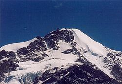
Chaukori is a tiny hill station in the Pithoragarh district set among the lofty peaks, of the western Himalayan Range in the Kumaon Division of Uttarakhand, India. To the north is Tibet and to the south is Terai...
in the Pithoragarh district
Pithoragarh District
Pithoragarh district is the easternmost Himalayan district in the state of Uttarakhand, India. It is naturally landscaped with high Himalayan mountains, snow capped peaks, passes, valleys, alpine meadows, forests, waterfalls, perennial rivers, glaciers and springs. The flora and fauna of this area...
, the most eastern Himalayan
Himalayas
The Himalaya Range or Himalaya Mountains Sanskrit: Devanagari: हिमालय, literally "abode of snow"), usually called the Himalayas or Himalaya for short, is a mountain range in Asia, separating the Indian subcontinent from the Tibetan Plateau...
district in the state of Uttarakhand
Uttarakhand
Uttarakhand , formerly Uttaranchal, is a state in the northern part of India. It is often referred to as the Land of Gods due to the many holy Hindu temples and cities found throughout the state, some of which are among Hinduism's most spiritual and auspicious places of pilgrimage and worship...
, India
India
India , officially the Republic of India , is a country in South Asia. It is the seventh-largest country by geographical area, the second-most populous country with over 1.2 billion people, and the most populous democracy in the world...
. It is accessible by road. Closest prominent villages include Dhanoli, Bana, Bhattigaon, Banoli,quarali,tripuradevi and Sangarh. A quite, beautiful and worthseeing place known for sight seeing of Himalaya peaks Such as Nandadevi and Panchachuli.
Geography
Berinag is located at 29.80°N 80.07°E. It has an average elevation of 1,740 metres (4,180 feet).Transport
- Nearest airport is Naini Saini, PithoragarhPithoragarhPithoragarh, is a city with a Municipal Board in the Pithoragarh district in the Indian state of Uttarakhand, was carved out of district of Almora in 1962.-Geography:...
: 112 km. - Nearest rail station is KathgodamKathgodamKathgodam is a town in the Nainital district of Uttarakhand state of India. It is part of the twin township of Haldwani-Kathgodam , and is immediately north of Haldwani.-History:...
: 214 km. - Chaukori is well connected by road with AlmoraAlmoraAlmora is a municipal board, a cantonment town in the Almora district in the state of Uttarakhand, India. Almora was founded in 1568.It is a town bustling with activity and a rich cultural heritage and history. It is considered the cultural heart of the Kumaon region of...
-100 k, Nainital-183 km, BageshwarBageshwarBageshwar is a city and a municipal board in Bageshwar district in the state of Uttarakhand, India. It is also the administrative headquarters of Bageshwar district....
-56 km, PithoragarhPithoragarhPithoragarh, is a city with a Municipal Board in the Pithoragarh district in the Indian state of Uttarakhand, was carved out of district of Almora in 1962.-Geography:...
-85 km
External links
- Pithoragar district website
- Map and photos of area
- Temples in the general area
- {http://berinag.com/ Tourist website ]