
Bath Beach, Brooklyn
Encyclopedia

New York City
New York is the most populous city in the United States and the center of the New York Metropolitan Area, one of the most populous metropolitan areas in the world. New York exerts a significant impact upon global commerce, finance, media, art, fashion, research, technology, education, and...
Borough of Brooklyn
Brooklyn
Brooklyn is the most populous of New York City's five boroughs, with nearly 2.6 million residents, and the second-largest in area. Since 1896, Brooklyn has had the same boundaries as Kings County, which is now the most populous county in New York State and the second-most densely populated...
in the United States
United States
The United States of America is a federal constitutional republic comprising fifty states and a federal district...
. It is located at the southwestern edge of the borough on Gravesend Bay.
Geography
Sometimes erroneously thought to be part of BensonhurstBensonhurst, Brooklyn
Bensonhurst is a neighborhood located in the southwestern part of the New York City borough of Brooklyn.-Geography:Sometimes erroneously thought to include all or parts of such neighborhoods as Bath Beach, Dyker Heights, and Borough Park, or to be defined by the streets where the concentration of...
, Bath Beach is actually separated from that neighborhood by 86th Street to the northeast. To the north, also across 86th Street, lies New Utrecht. To the northwest across 14th Avenue is Dyker Beach Park and Golf Course, and to the southeast across Stillwell Avenue is the neighborhood of Gravesend
Gravesend, Brooklyn
Gravesend is a neighborhood in the south-central section of the New York City borough of Brooklyn, USA.The derivation of the name is unclear. Some speculate that it was named after the English seaport of Gravesend, Kent. An alternative explanation suggests that it was named by Willem Kieft for the...
. To the south, across Gravesend Bay and Coney Island Creek
Coney Island Creek
Coney Island Creek encompasses two sea inlets in Brooklyn, New York City, one separating Coney Island from the neighborhoods of Gravesend and Bath Beach, the other separating the neighborhoods of Sheepshead Bay and Manhattan Beach...
, are Seagate
Seagate, Brooklyn
Sea Gate is a private, gated community at the far western end of Coney Island at the southwestern tip of the New York City borough of Brooklyn. It contains mostly single-family homes, some directly on Gravesend Bay...
and Coney Island
Coney Island
Coney Island is a peninsula and beach on the Atlantic Ocean in southern Brooklyn, New York, United States. The site was formerly an outer barrier island, but became partially connected to the mainland by landfill....
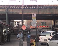
. Bath Beach is served by the D
D (New York City Subway service)
The D Sixth Avenue Express is a rapid transit service of the New York City Subway. It is colored orange on route signs, station signs, and the official subway map, since it uses the IND Sixth Avenue Line through Manhattan....
elevated subway line of the New York City Subway
New York City Subway
The New York City Subway is a rapid transit system owned by the City of New York and leased to the New York City Transit Authority, a subsidiary agency of the Metropolitan Transportation Authority and also known as MTA New York City Transit...
system, also called the BMT West End Line
BMT West End Line
The BMT West End Line is a line of the New York City Subway, serving the Brooklyn, communities of Borough Park, New Utrecht, Bensonhurst, Bath Beach and Coney Island. The D train operates on the line at all times, providing service to Manhattan and the Bronx via the IND Sixth Avenue Line...
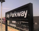
. Stations along the line serving the community are 18th Avenue, 20th Avenue, Bay Parkway, 25th Avenue, and Bay 50th Street.
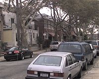
Unique street grid
Cropsey Avenue
Cropsey Avenue is a major street in Brooklyn, New York. It generally runs northwest-southeast, from Bath Beach to Coney Island. It forms the northeastern boundary of Dreier Offerman Park....
, Bath Avenue, Benson Avenue, and 86th Street, with another, Harway Avenue, running from Stillwell only as far as Twenty-Fourth Avenue. The one-way cross-streets are numbered, with the word "Bay" attached (to distinguish them, for postal reasons, from other numbering systems elsewhere in the borough), from Bay 7th Street in the northwest through Bay 50th Street in the southeast. Confusingly for first-time visitors, every third "Bay" numbered street is replaced with a two-way numbered avenue, from Fourteenth Avenue in the northwest to Twenty-Eighth Avenue in the southeast (except for what would be Twenty-Second Avenue, which is called Bay Parkway). These avenues (as well as 86th Street) are part of a larger grid that encompasses other neighborhoods to the north and west.
Demographics
Beginnings
The term "Bath Beach" once described the beach resort specifically as part of the community of Bath, New York. Bath and Bath Beach are now more or less synonymous. The population of Bath Beach received a boost at the end of 1863 when steam dummySteam dummy
A steam dummy or dummy engine, in the United States of America and Canada, was a steam engine enclosed in a wooden box structure made to resemble a railroad passenger coach....
railroad service connected the community to the City of Brooklyn horsecar
Horsecar
A horsecar or horse-drawn tram is an animal-powered streetcar or tram.These early forms of public transport developed out of industrial haulage routes that had long been in existence, and from the omnibus routes that first ran on public streets in the 1820s, using the newly improved iron or steel...
system terminal at 25th Street and 5th Avenue in Sunset Park
Sunset Park, Brooklyn
Sunset Park is a neighborhood in the western section of the New York City borough of Brooklyn, USA. It is bounded by Greenwood Heights to the north, Borough Park to the east, Bay Ridge to the south, and Upper New York Bay to the west...
.
Shore Parkway construction
Despite its name, the neighborhood no longer has an actual beachBeach
A beach is a geological landform along the shoreline of an ocean, sea, lake or river. It usually consists of loose particles which are often composed of rock, such as sand, gravel, shingle, pebbles or cobblestones...
. The beach was paved over during the mid-twentieth century to create the Shore Parkway
Belt Parkway
The Belt System is a series of connected limited-access highways that form a belt-like circle around the New York City boroughs of Brooklyn and Queens. The system comprises four officially separate parkways; however, three of the four are signed as the Belt Parkway...
. On the northwestern half, a promenade was constructed to allow residents access to a sea wall. The southwestern half, filled in with land excavated from the construction of the nearby Verrazano-Narrows Bridge
Verrazano-Narrows Bridge
The Verrazano-Narrows Bridge is a double-decked suspension bridge that connects the boroughs of Staten Island and Brooklyn in New York City at the Narrows, the reach connecting the relatively protected upper bay with the larger lower bay....
during the 1960s, now houses a large park with ballfields and the Caesar's Bay shopping center.
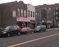
Saturday Night Fever
During the 1970s, Bath Beach's commercial strip along 86th Street was used for scenes in the 1971 feature film The French ConnectionThe French Connection (film)
This article is about the 1971 film. For the British fashion label, see French Connection .The French Connection is a 1971 American crime film directed by William Friedkin. The film was adapted and fictionalized by Ernest Tidyman from the non-fiction book by Robin Moore...
, in the opening credits to the popular television series Welcome Back, Kotter
Welcome Back, Kotter
Welcome Back, Kotter was an American television sitcom starring Gabe Kaplan and featuring a young John Travolta.It originally aired on the ABC network from September 9, 1975 to June 8, 1979.-Premise:...
, and most famously in the opening scene of the 1977 feature film Saturday Night Fever
Saturday Night Fever
Saturday Night Fever is a 1977 drama film directed by John Badham and starring: John Travolta as Tony Manero, an immature young man whose weekends are spent visiting a local Brooklyn discothèque; Karen Lynn Gorney as his dance partner and eventual friend; and Donna Pescow as Tony's former dance...
. Tony Manero, the lead character (played by John Travolta
John Travolta
John Joseph Travolta is an American actor, dancer and singer. Travolta first became known in the 1970s, after appearing on the television series Welcome Back, Kotter and starring in the box office successes Saturday Night Fever and Grease...
), walks along the sidewalk, admires shoes in a storefront window, buys two (stacked) slices of pizza through a pizzeria window-counter, and ends up at the hardware store where he works (based on a real hardware store on Fifth Avenue in nearby Bay Ridge).