

Belt Parkway
Encyclopedia
The Belt System is a series of connected limited-access highways that form a belt-like circle around the New York City
boroughs of Brooklyn
and Queens
. The system comprises four officially separate parkways; however, three of the four are signed as the Belt Parkway. The three parkways that make up the signed Belt Parkway—the Shore Parkway, the Southern Parkway (not to be confused with the Southern State Parkway
), and the Laurelton Parkway—are a combined 25.29 miles (40.7 km) in length.
 The Shore Parkway, Southern Parkway, Laurelton Parkway, and Cross Island Parkway
are collectively known as the "Belt System". The four components of the Belt System are designated as NY 907C, NY 907D, NY 907B, and NY 907A, respectively, by the New York State Department of Transportation
. All four numbers are reference route designations and are not signed
. Excluding the Cross Island Parkway, the other three segments are now known collectively as the official "Belt Parkway". It is designated an east–west route, and its exit numbering system begins, in standard fashion, at the western terminus of the Shore Parkway, the westernmost parkway in the system. The numbering increases as the parkway proceeds eastward, and continues onto the Cross Island at the eastern terminus of the Belt Parkway. The north–south parkway retains the numbering scheme to its northern terminus.
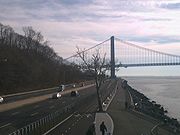
. The Shore, the part of the system many think of when they mention "Belt Parkway," makes a large arc to the south, passing under the Verrazano Narrows Bridge and turning southeast. Entering the Coney Island
area, the parkway turns east, roughly following the former path of Coney Island Creek
before turning northeast to skip across former islands in Jamaica Bay
and reach the Southern Parkway. The Shore Parkway Greenway lies between the Parkway and the shore, connecting Owl's Head Park to Coney Island, and Brigham Street in Sheephead Bay
to Howard Beach
.
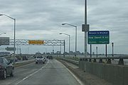
 Shore Road Drive parallels the first stretch of the Shore Parkway. Exit 1 is for the Shore Road Drive (unsigned). The road makes a curve to the south after exit 1 and heads towards the Verrazano Bridge. The Shore Parkway goes through Shore Road Park until exit 2, which is for Shore Road (unsigned), 4th Avenue, and Fort Hamilton Parkway. Exit 3 is on the westbound side only, while going eastbound the next exit is number 4. Exit 3 is for the Verrazano Narrows Bridge towards Staten Island
. In Dyker Beach Park, exit 4 interchanges for Bay 8th Street. Exit 5 is next, for the Bay Parkway, which heads northward towards the neighborhood of Midwood.
Exit 6 going westbound is for Cropsey Avenue
, which heads towards Coney Island
. Exit 6 in the westbound direction is split into exits 6S and 6N. Exit 6N has access to Stillwell Avenue
. Exit 7 going eastbound is for Ocean Parkway
while westbound it is for Shell Road and is numbered 7A. Exit 7B going westbound is for Ocean Parkway. Exit 8 going westbound is the first signed exit for Coney Island. The exit is also for East 14th Street (unsigned) and Sheepshead Bay Road (unsigned). Exits 9A and 9B going eastbound are for Knapp Street
and Sheepshead Bay. Exits 11S and 11N make a full cloverleaf interchange for Flatbush Avenue.
 Exit 13 is next for Rockaway Parkway
, which begins at a traffic circle. Exit 14 comes next for Pennsylvania Avenue
. As the Shore Parkway gets closer to Jamaica, exit 15 comes for Erskine Street. After exits 17S and 17N for State Route 27 and Cross Bay Boulevard
, the road becomes known as the Southern Parkway.
In 1969, the New York City Council
renamed the Shore Parkway Leif Ericson Drive between Exit 2 and Exit 9, to recognize the large Scandinavian population in Bay Ridge.
in Nassau
and Suffolk
counties, is located entirely within the median of Conduit Boulevard
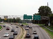
, NY 27. between Cross Bay Boulevard and Brookville Boulevard. It passes by JFK International Airport. After Exits 17N/17S, the Belt Parkway interchanges with NY 878 (the Nassau Expressway), I-678 (the Van Wyck Expressway), and going eastbound, also the JFK Expressway as well as Lefferts Boulevard, at Exit 19 (Westbound Lefferts Boulevard is Exit 18B, the Nassau Expressway and the Van Wyck is Exit 19, and the JFK Expressway is Exit 20). The next exit is for 150 Street and Rockaway Boulevard, which is Exit 20 eastbound and Exit 21A westbound. Exit 21B is Farmers Boulevard and Guy R. Brewer Boulevard. After that comes Springfield Boulevard at Exit 22. The parkway now turns to the northeast. North and South Conduit Avenues take NY 27 to Long Island. there is an eastbound exit to South Conduit Avenue which is Exit 23B. Going westbound, just before the curve, there is access to North Conduit Avenue at Exit 23A. Past the curve the Laurelton Parkway begins.
, then west to the Bronx-Whitestone Bridge, where it terminates at the Whitestone Expressway. For more information see the Cross Island Parkway main page.
 The Belt Parkway was proposed by builder and highway advocate Robert Moses
in 1930 to provide modern highway access to Manhattan and to connect to, and use similar design principles to, parkway
s already constructed on Long Island
and Westchester County, New York
. Construction began in 1934. The full loop was completed when the Brooklyn-Queens Expressway (also known as the "BQE") was finished in 1960.
to the Shore Parkway; the entirety of the Shore, Southern, Laurelton, and Cross Island Parkways; the Whitestone Parkway from the Cross Island to the Grand Central Parkway
; and the Grand Central from the Whitestone to the Triborough Bridge
.
All the original parkways, except the Gowanus, were built on grassy rights-of-way with trees, in a more pleasant surrounding than most highways of their time. The Gowanus Parkway was built as an elevated structure over Third and Hamilton Avenues in order to avoid the active docks and industrial areas including Sunset Park, Brooklyn
.
s, which had "suburban" registrations, were excluded but they were later allowed, along with passenger-registered SUVs and vans.
The system was not completed as a parkway, and some portions of the original system were converted to expressways
, which allows commercial traffic to use them. These expressway portions included the Gowanus Expressway, replacing Gowanus Parkway as a connector between Manhattan
and the Verrazano-Narrows Bridge
to Staten Island
and New Jersey
(now signed as part of Interstate 278); Whitestone Expressway, which converted Whitestone Parkway into a truck route to connect the Van Wyck Expressway to the Bronx-Whitestone Bridge (now signed as part of Interstate 678); and the Brooklyn-Queens Expressway, built as an expressway to connect the Gowanus Parkway/Expressway to the Triborough Bridge and Grand Central Parkway to complete the system (now signed as part of Interstate 278).
|rowspan=16|Kings
|rowspan=2|Bay Ridge
|rowspan=2|0.00
|
|
|Westbound exit and eastbound entrance
|-
|1
|65th-67th Streets
|
|-
|rowspan=2|Fort Hamilton
|rowspan=2|3.38
|2
|4th Avenue / Fort Hamilton Parkway – Verrazano-Narrows Bridge
|
|-
|3
|
|Westbound exit and eastbound entrance
|-
|rowspan=2|Bath Beach
|4.47
|4
|Bay 8th Street/14th Avenue
|
|-
|5.63
|5
|Bay Parkway
|
|-
|rowspan=3|Gravesend
|6.73
|6
|Cropsey Avenue
/ Stillwell Avenue
– Coney Island
|Signed as exits 6S (south) and 6N (north) westbound
|-
|rowspan=2|7.81
|7A
|Shell Road – Coney Island
|Westbound exit and eastbound entrance; formerly part of exit 7S
|-
|7B
|Ocean Parkway
– Coney Island
, Brighton Beach
|Signed as exit 7 eastbound; formerly split into exits 7S and 7N
|-
|rowspan=2|Sheepshead Bay
|7.89
|8
|Coney Island Avenue
– Brighton Beach
|
|-
|9.69
|9
|Knapp Street
– Sheepshead Bay
|Two exits - 9A and 9B - eastbound; both lead to Knapp Street
|-
|Floyd Bennett Field
|11.09
|11
|Flatbush Avenue – Rockaways
, Marine Park
, Kings Plaza
|Signed as exits 11S (south) and 11N (north)
|-
|Bergen Beach
|
|
|Jamaica Bay Riding Academy
|Eastbound exit and entrance
|-
|Canarsie
|14.38
|13
|Rockaway Parkway
|
|-
|rowspan=2|Starrett City
|15.42
|14
|Pennsylvania Avenue
|
|-
|
|15
|Erskine Street
|
|-
|rowspan=15|Queens
|rowspan=2|Howard Beach
|17.91
|17
|Cross Bay Boulevard
/ Cohancy Street – Woodhaven, Rockaways
|Signed as exits 17S (south) and 17N (north) westbound
|-
|
|17W
|North Conduit Avenue (NY 27
west)
|Westbound exit and eastbound entrance
|-
|rowspan=3|South Ozone Park
|18.30
|18B
|Lefferts Boulevard – Aqueduct Racetrack
|Eastbound exit is part of exit 19
|-
|
|19
|
|Westbound exit only connects to I-678 north; access to Kennedy Airport is via exit 20
|-
|
|20
|JFK Expressway
– Kennedy Airport
|Westbound exit and eastbound entrance
|-
|rowspan=3|Springfield Gardens
|20.45
|21A
|150th Street, Rockaway Boulevard
|Signed as exit 20 eastbound
|-
|22.29
|21B
|Farmers Boulevard, Guy R. Brewer Boulevard
|
|-
|
|22
|Springfield Boulevard
|
|-
|rowspan=7|Laurelton
|23.67
|23A
|North Conduit Avenue (NY 27
west), 225th Street
|Westbound exit only
|-
|23.67
|23B
|
|Eastbound exit and westbound entrance
|-
|
|24A
|Francis Lewis Boulevard
|No westbound entrance
|-
|24.26
|24B
|Merrick Boulevard
|Eastbound exit is via exit 24A
|-
|
|24B
|130th Avenue
|Eastbound exit, eastbound and westbound entrance
|-
|25.29
|25A
|
|Eastbound exit and westbound entrance
|-
|25.29
|
|
|Eastbound exit and westbound entrance
The exit numbering system uses sequential, not mile-based, numbers. Also, "directional" letters (e.g. N-S; E-W) are found here.
New York City
New York is the most populous city in the United States and the center of the New York Metropolitan Area, one of the most populous metropolitan areas in the world. New York exerts a significant impact upon global commerce, finance, media, art, fashion, research, technology, education, and...
boroughs of Brooklyn
Brooklyn
Brooklyn is the most populous of New York City's five boroughs, with nearly 2.6 million residents, and the second-largest in area. Since 1896, Brooklyn has had the same boundaries as Kings County, which is now the most populous county in New York State and the second-most densely populated...
and Queens
Queens
Queens is the easternmost of the five boroughs of New York City. The largest borough in area and the second-largest in population, it is coextensive with Queens County, an administrative division of New York state, in the United States....
. The system comprises four officially separate parkways; however, three of the four are signed as the Belt Parkway. The three parkways that make up the signed Belt Parkway—the Shore Parkway, the Southern Parkway (not to be confused with the Southern State Parkway
Southern State Parkway
The Southern State Parkway is a long limited-access highway on Long Island, in the U.S. state of New York...
), and the Laurelton Parkway—are a combined 25.29 miles (40.7 km) in length.
Route description
Cross Island Parkway
Cross Island Parkway, also known as the 100th Infantry Division Parkway, is a parkway within New York State. The parkway is a part of the Belt Parkway system that runs along the perimeter of the borough of Queens in New York City...
are collectively known as the "Belt System". The four components of the Belt System are designated as NY 907C, NY 907D, NY 907B, and NY 907A, respectively, by the New York State Department of Transportation
New York State Department of Transportation
The New York State Department of Transportation is responsible for the development and operation of highways, railroads, mass transit systems, ports, waterways and aviation facilities in the U.S...
. All four numbers are reference route designations and are not signed
Unsigned highway
An unsigned highway is a highway that has been assigned a route number, but does not bear conventional road markings that would normally be used to identify the route with that number...
. Excluding the Cross Island Parkway, the other three segments are now known collectively as the official "Belt Parkway". It is designated an east–west route, and its exit numbering system begins, in standard fashion, at the western terminus of the Shore Parkway, the westernmost parkway in the system. The numbering increases as the parkway proceeds eastward, and continues onto the Cross Island at the eastern terminus of the Belt Parkway. The north–south parkway retains the numbering scheme to its northern terminus.
Shore Parkway
The Shore Parkway begins at the Gowanus Expressway near the east end of the Verrazano Narrows Bridge and proceeds eastward through BrooklynBrooklyn
Brooklyn is the most populous of New York City's five boroughs, with nearly 2.6 million residents, and the second-largest in area. Since 1896, Brooklyn has had the same boundaries as Kings County, which is now the most populous county in New York State and the second-most densely populated...
. The Shore, the part of the system many think of when they mention "Belt Parkway," makes a large arc to the south, passing under the Verrazano Narrows Bridge and turning southeast. Entering the Coney Island
Coney Island
Coney Island is a peninsula and beach on the Atlantic Ocean in southern Brooklyn, New York, United States. The site was formerly an outer barrier island, but became partially connected to the mainland by landfill....
area, the parkway turns east, roughly following the former path of Coney Island Creek
Coney Island Creek
Coney Island Creek encompasses two sea inlets in Brooklyn, New York City, one separating Coney Island from the neighborhoods of Gravesend and Bath Beach, the other separating the neighborhoods of Sheepshead Bay and Manhattan Beach...
before turning northeast to skip across former islands in Jamaica Bay
Jamaica Bay
Jamaica Bay is located on the southwestern tip of Long Island in the boroughs of Brooklyn and Queens, New York City, and the town of Hempstead, New York/hamlet of Inwood...
and reach the Southern Parkway. The Shore Parkway Greenway lies between the Parkway and the shore, connecting Owl's Head Park to Coney Island, and Brigham Street in Sheephead Bay
Sheepshead Bay, Brooklyn
Sheepshead Bay is a bay separating the mainland of Brooklyn, New York City from the eastern portion of Coney Island, the latter originally a barrier island but now effectively an extension of the mainland with peninsulas both east and west...
to Howard Beach
Howard Beach, Queens
Howard Beach is a suburban neighborhood in the southwestern portion of the borough of Queens in New York City. It is bordered in the north by the Belt Parkway and South Conduit Avenue in Ozone Park, the south by Jamaica Bay in Broad Channel, the east by 102nd-104th streets, and the west by 78th...
.
Staten Island
Staten Island is a borough of New York City, New York, United States, located in the southwest part of the city. Staten Island is separated from New Jersey by the Arthur Kill and the Kill Van Kull, and from the rest of New York by New York Bay...
. In Dyker Beach Park, exit 4 interchanges for Bay 8th Street. Exit 5 is next, for the Bay Parkway, which heads northward towards the neighborhood of Midwood.
Exit 6 going westbound is for Cropsey Avenue
Cropsey Avenue
Cropsey Avenue is a major street in Brooklyn, New York. It generally runs northwest-southeast, from Bath Beach to Coney Island. It forms the northeastern boundary of Dreier Offerman Park....
, which heads towards Coney Island
Coney Island
Coney Island is a peninsula and beach on the Atlantic Ocean in southern Brooklyn, New York, United States. The site was formerly an outer barrier island, but became partially connected to the mainland by landfill....
. Exit 6 in the westbound direction is split into exits 6S and 6N. Exit 6N has access to Stillwell Avenue
Stillwell Avenue
Stillwell Avenue is a major north/south thoroughfare in southern Brooklyn and the central section of Coney Island. It is 2.4 miles long and begins at a dead end on Coney Island. Traffic is two way. The road goes north, leaving Coney Island, ending at Bay Parkway, where the road continues as the...
. Exit 7 going eastbound is for Ocean Parkway
Ocean Parkway (Brooklyn)
Ocean Parkway is a broad boulevard in the west central portion of the borough of Brooklyn in New York City.-Route description:Ocean Parkway extends over a distance of about five miles , running almost north to south from the vicinity of Prospect Park to Brighton Beach...
while westbound it is for Shell Road and is numbered 7A. Exit 7B going westbound is for Ocean Parkway. Exit 8 going westbound is the first signed exit for Coney Island. The exit is also for East 14th Street (unsigned) and Sheepshead Bay Road (unsigned). Exits 9A and 9B going eastbound are for Knapp Street
Knapp Street
Knapp Street is a major street in the Sheepshead Bay neighborhood of Brooklyn, New York. It runs north to south, with its northern terminus at Gerritsen Avenue in Marine Park, and its southern terminus at Emmons Avenue in Sheepshead Bay. Knapp Street has an interchange with the Belt Parkway at...
and Sheepshead Bay. Exits 11S and 11N make a full cloverleaf interchange for Flatbush Avenue.
Rockaway Parkway
Rockaway Parkway is a major commercial street in the Canarsie neighborhood of Brooklyn, New York.Canarsie High School, as well as a firehouse and several homes and businesses are on Rockaway Parkway. The Rockaway Parkway station is the southern terminus of the BMT Canarsie Line...
, which begins at a traffic circle. Exit 14 comes next for Pennsylvania Avenue
Pennsylvania Avenue (Brooklyn)
Pennsylvania Avenue is a major street in Brooklyn, New York. It generally runs north to south, from the Jackie Robinson Parkway in Broadway Triangle to the Belt Parkway in Starrett City...
. As the Shore Parkway gets closer to Jamaica, exit 15 comes for Erskine Street. After exits 17S and 17N for State Route 27 and Cross Bay Boulevard
Cross Bay Boulevard
Cross Bay Boulevard is the main north–south road in Howard Beach, a neighborhood in the New York City borough of Queens. In the south, it originates in The Rockaways, runs over the Cross Bay Bridge into Broad Channel and then over the Joseph P. Addabbo Memorial Bridge into Howard Beach...
, the road becomes known as the Southern Parkway.
In 1969, the New York City Council
New York City Council
The New York City Council is the lawmaking body of the City of New York. It has 51 members from 51 council districts throughout the five boroughs. The Council serves as a check against the mayor in a "strong" mayor-council government model. The council monitors performance of city agencies and...
renamed the Shore Parkway Leif Ericson Drive between Exit 2 and Exit 9, to recognize the large Scandinavian population in Bay Ridge.
Southern Parkway
The Southern Parkway, distinct from the Southern State ParkwaySouthern State Parkway
The Southern State Parkway is a long limited-access highway on Long Island, in the U.S. state of New York...
in Nassau
Nassau County, New York
Nassau County is a suburban county on Long Island, east of New York City in the U.S. state of New York, within the New York Metropolitan Area. As of the 2010 census, the population was 1,339,532...
and Suffolk
Suffolk County, New York
Suffolk County is a county located in the U.S. state of New York on the eastern portion of Long Island. As of the 2010 census, the population was 1,493,350. It was named for the county of Suffolk in England, from which its earliest settlers came...
counties, is located entirely within the median of Conduit Boulevard
Conduit Boulevard
Conduit Boulevard is an arterial road in New York City. The divided highway runs from Atlantic Avenue in Cypress Hills, Brooklyn to Hook Creek Boulevard in Rosedale, Queens at the Nassau County border...
, NY 27. between Cross Bay Boulevard and Brookville Boulevard. It passes by JFK International Airport. After Exits 17N/17S, the Belt Parkway interchanges with NY 878 (the Nassau Expressway), I-678 (the Van Wyck Expressway), and going eastbound, also the JFK Expressway as well as Lefferts Boulevard, at Exit 19 (Westbound Lefferts Boulevard is Exit 18B, the Nassau Expressway and the Van Wyck is Exit 19, and the JFK Expressway is Exit 20). The next exit is for 150 Street and Rockaway Boulevard, which is Exit 20 eastbound and Exit 21A westbound. Exit 21B is Farmers Boulevard and Guy R. Brewer Boulevard. After that comes Springfield Boulevard at Exit 22. The parkway now turns to the northeast. North and South Conduit Avenues take NY 27 to Long Island. there is an eastbound exit to South Conduit Avenue which is Exit 23B. Going westbound, just before the curve, there is access to North Conduit Avenue at Exit 23A. Past the curve the Laurelton Parkway begins.
Laurelton Parkway
The Laurelton Parkway is a short connector between the Southern Parkway and the Cross Island Parkway. There is a one-way service road on the west side going westbound, and on the east side, the two-way Brookville Boulevard acts as a service road. Going eastbound, Exit 24A is for Francis Lewis Boulevard and Merrick Boulevard. Going westbound, Exit 24B is a separate exit for Merrick Boulevard. It also serves 130 Avenue. There is also a westbound-only exit, Exit 23A, which goes to North Conduit Avenue. Just before the end of the parkway, Exit 25B serves Elmont Road and Linden Boulevard going eastbound, and Exit 25A goes to the Southern State Parkway. The Belt (Laurelton) Parkway now becomes the Cross Island Parkway.Cross Island Parkway
The Cross Island Parkway continues north from the interchange with the Southern State Parkway near the border of Nassau CountyNassau County, New York
Nassau County is a suburban county on Long Island, east of New York City in the U.S. state of New York, within the New York Metropolitan Area. As of the 2010 census, the population was 1,339,532...
, then west to the Bronx-Whitestone Bridge, where it terminates at the Whitestone Expressway. For more information see the Cross Island Parkway main page.
History
Robert Moses
Robert Moses was the "master builder" of mid-20th century New York City, Long Island, Rockland County, and Westchester County, New York. As the shaper of a modern city, he is sometimes compared to Baron Haussmann of Second Empire Paris, and is one of the most polarizing figures in the history of...
in 1930 to provide modern highway access to Manhattan and to connect to, and use similar design principles to, parkway
Parkway
The term parkway has several distinct principal meanings and numerous synonyms around the world, for either a type of landscaped area or a type of road.Type of landscaped area:...
s already constructed on Long Island
Long Island
Long Island is an island located in the southeast part of the U.S. state of New York, just east of Manhattan. Stretching northeast into the Atlantic Ocean, Long Island contains four counties, two of which are boroughs of New York City , and two of which are mainly suburban...
and Westchester County, New York
Westchester County, New York
Westchester County is a county located in the U.S. state of New York. Westchester covers an area of and has a population of 949,113 according to the 2010 Census, residing in 45 municipalities...
. Construction began in 1934. The full loop was completed when the Brooklyn-Queens Expressway (also known as the "BQE") was finished in 1960.
The Belt System
Though some signage bears the name "Belt Parkway," the original plan never called for a highway of that name, rather a system of different named parkways called the "Belt System." The Belt System is made up of a series of interconnecting highways, none of which are actually named the Belt Parkway. Originally, the highways were the Gowanus Parkway from the Brooklyn-Battery TunnelBrooklyn-Battery Tunnel
Interstate 478s entire length consists of the Brooklyn–Battery Tunnel and its approaches. Its south end is at Interstate 278, and its north end is at NY 9A ....
to the Shore Parkway; the entirety of the Shore, Southern, Laurelton, and Cross Island Parkways; the Whitestone Parkway from the Cross Island to the Grand Central Parkway
Grand Central Parkway
The Grand Central Parkway is a parkway that stretches from the RFK-Triborough Bridge in New York City to Nassau County on Long Island. At the Queens-Nassau border, it becomes the Northern State Parkway, which runs across the northern part of Long Island through Nassau County and into Suffolk...
; and the Grand Central from the Whitestone to the Triborough Bridge
Triborough Bridge
The Robert F. Kennedy ' Bridge, formerly known as the Triborough Bridge , is a complex of three separate bridges in New York City, United States...
.
All the original parkways, except the Gowanus, were built on grassy rights-of-way with trees, in a more pleasant surrounding than most highways of their time. The Gowanus Parkway was built as an elevated structure over Third and Hamilton Avenues in order to avoid the active docks and industrial areas including Sunset Park, Brooklyn
Sunset Park, Brooklyn
Sunset Park is a neighborhood in the western section of the New York City borough of Brooklyn, USA. It is bounded by Greenwood Heights to the north, Borough Park to the east, Bay Ridge to the south, and Upper New York Bay to the west...
.
Conversion and completion
Like most parkways in New York State, the parkways comprising the Belt System were closed to commercial traffic, including any vehicle with a non-passenger registration and all commercial trucking of any size. Originally even station wagonStation wagon
A station wagon is a body style variant of a sedan/saloon with its roof extended rearward over a shared passenger/cargo volume with access at the back via a third or fifth door , instead of a trunk lid...
s, which had "suburban" registrations, were excluded but they were later allowed, along with passenger-registered SUVs and vans.
The system was not completed as a parkway, and some portions of the original system were converted to expressways
Controlled-access highway
A controlled-access highway is a highway designed exclusively for high-speed vehicular traffic, with all traffic flow and ingress/egress regulated...
, which allows commercial traffic to use them. These expressway portions included the Gowanus Expressway, replacing Gowanus Parkway as a connector between Manhattan
Manhattan
Manhattan is the oldest and the most densely populated of the five boroughs of New York City. Located primarily on the island of Manhattan at the mouth of the Hudson River, the boundaries of the borough are identical to those of New York County, an original county of the state of New York...
and the Verrazano-Narrows Bridge
Verrazano-Narrows Bridge
The Verrazano-Narrows Bridge is a double-decked suspension bridge that connects the boroughs of Staten Island and Brooklyn in New York City at the Narrows, the reach connecting the relatively protected upper bay with the larger lower bay....
to Staten Island
Staten Island
Staten Island is a borough of New York City, New York, United States, located in the southwest part of the city. Staten Island is separated from New Jersey by the Arthur Kill and the Kill Van Kull, and from the rest of New York by New York Bay...
and New Jersey
New Jersey
New Jersey is a state in the Northeastern and Middle Atlantic regions of the United States. , its population was 8,791,894. It is bordered on the north and east by the state of New York, on the southeast and south by the Atlantic Ocean, on the west by Pennsylvania and on the southwest by Delaware...
(now signed as part of Interstate 278); Whitestone Expressway, which converted Whitestone Parkway into a truck route to connect the Van Wyck Expressway to the Bronx-Whitestone Bridge (now signed as part of Interstate 678); and the Brooklyn-Queens Expressway, built as an expressway to connect the Gowanus Parkway/Expressway to the Triborough Bridge and Grand Central Parkway to complete the system (now signed as part of Interstate 278).
Exit list
|-|rowspan=16|Kings
|rowspan=2|Bay Ridge
Bay Ridge, Brooklyn
Bay Ridge is a neighborhood in the southwest corner of the New York City borough of Brooklyn, USA. It is bounded by Sunset Park on the north, Seventh Avenue and Dyker Heights on the east, The Narrows Strait, which partially houses the Belt Parkway, on the west and 86th Street and Fort Hamilton on...
|rowspan=2|0.00
|
|
|Westbound exit and eastbound entrance
|-
|1
|65th-67th Streets
|
|-
|rowspan=2|Fort Hamilton
Fort Hamilton, Brooklyn
Fort Hamilton is a neighborhood in the far southwestern corner of the New York City borough of Brooklyn. It is located south of, and often considered part of, Bay Ridge. The area stretches from 86th Street as its northern border to 101st Street/the Narrows at the south; it is bounded by New York...
|rowspan=2|3.38
|2
|4th Avenue / Fort Hamilton Parkway – Verrazano-Narrows Bridge
Verrazano-Narrows Bridge
The Verrazano-Narrows Bridge is a double-decked suspension bridge that connects the boroughs of Staten Island and Brooklyn in New York City at the Narrows, the reach connecting the relatively protected upper bay with the larger lower bay....
|
|-
|3
|
|Westbound exit and eastbound entrance
|-
|rowspan=2|Bath Beach
Bath Beach, Brooklyn
Bath Beach is a neighborhood in the New York City Borough of Brooklyn in the United States. It is located at the southwestern edge of the borough on Gravesend Bay.-Geography:...
|4.47
|4
|Bay 8th Street/14th Avenue
|
|-
|5.63
|5
|Bay Parkway
|
|-
|rowspan=3|Gravesend
Gravesend, Brooklyn
Gravesend is a neighborhood in the south-central section of the New York City borough of Brooklyn, USA.The derivation of the name is unclear. Some speculate that it was named after the English seaport of Gravesend, Kent. An alternative explanation suggests that it was named by Willem Kieft for the...
|6.73
|6
|Cropsey Avenue
Cropsey Avenue
Cropsey Avenue is a major street in Brooklyn, New York. It generally runs northwest-southeast, from Bath Beach to Coney Island. It forms the northeastern boundary of Dreier Offerman Park....
/ Stillwell Avenue
Stillwell Avenue
Stillwell Avenue is a major north/south thoroughfare in southern Brooklyn and the central section of Coney Island. It is 2.4 miles long and begins at a dead end on Coney Island. Traffic is two way. The road goes north, leaving Coney Island, ending at Bay Parkway, where the road continues as the...
– Coney Island
Coney Island
Coney Island is a peninsula and beach on the Atlantic Ocean in southern Brooklyn, New York, United States. The site was formerly an outer barrier island, but became partially connected to the mainland by landfill....
|Signed as exits 6S (south) and 6N (north) westbound
|-
|rowspan=2|7.81
|7A
|Shell Road – Coney Island
Coney Island
Coney Island is a peninsula and beach on the Atlantic Ocean in southern Brooklyn, New York, United States. The site was formerly an outer barrier island, but became partially connected to the mainland by landfill....
|Westbound exit and eastbound entrance; formerly part of exit 7S
|-
|7B
|Ocean Parkway
Ocean Parkway (Brooklyn)
Ocean Parkway is a broad boulevard in the west central portion of the borough of Brooklyn in New York City.-Route description:Ocean Parkway extends over a distance of about five miles , running almost north to south from the vicinity of Prospect Park to Brighton Beach...
– Coney Island
Coney Island
Coney Island is a peninsula and beach on the Atlantic Ocean in southern Brooklyn, New York, United States. The site was formerly an outer barrier island, but became partially connected to the mainland by landfill....
, Brighton Beach
|Signed as exit 7 eastbound; formerly split into exits 7S and 7N
|-
|rowspan=2|Sheepshead Bay
Sheepshead Bay, Brooklyn
Sheepshead Bay is a bay separating the mainland of Brooklyn, New York City from the eastern portion of Coney Island, the latter originally a barrier island but now effectively an extension of the mainland with peninsulas both east and west...
|7.89
|8
|Coney Island Avenue
Coney Island Avenue
Coney Island Avenue is a roadway in the New York City borough of Brooklyn that runs north-south for a distance of roughly five miles, almost parallel to Ocean Parkway. It begins at Brighton Beach Avenue in Coney Island and goes north to Park Circle at the southwest corner of Prospect Park, where...
– Brighton Beach
|
|-
|9.69
|9
|Knapp Street
Knapp Street
Knapp Street is a major street in the Sheepshead Bay neighborhood of Brooklyn, New York. It runs north to south, with its northern terminus at Gerritsen Avenue in Marine Park, and its southern terminus at Emmons Avenue in Sheepshead Bay. Knapp Street has an interchange with the Belt Parkway at...
– Sheepshead Bay
|Two exits - 9A and 9B - eastbound; both lead to Knapp Street
|-
|Floyd Bennett Field
Floyd Bennett Field
Floyd Bennett Field is New York City's first municipal airport. While no longer used as an operational commercial, military or general aviation airfield, the New York Police Department still flies its helicopters from its heliport base there...
|11.09
|11
|Flatbush Avenue – Rockaways
Rockaway, Queens
The Rockaway Peninsula, informally The Rockaways, is the name of a peninsula of Long Island, all of which is located within the New York City borough of Queens. A popular summer resort area since the 1830s, Rockaway has become a mixture of lower, middle, and upper-class neighborhoods...
, Marine Park
Marine Park, Brooklyn
Marine Park is a public park located in the borough of Brooklyn in New York City. Its 798 acres surround the westernmost inlet of Jamaica Bay. Most of the land for Marine Park, Brooklyn was donated to New York City to be turned into public park land by the Whitney family in 1920 and by Frederic B....
, Kings Plaza
Kings Plaza
Kings Plaza is a shopping center that opened in 1970, within the Marine Park/Mill Basin section of Brooklyn, east of Flatbush Avenue. Owned by Vornado Realty Trust, Kings Plaza originally hosted the now-defunct Alexander's , as well as Macy's department store chains...
|Signed as exits 11S (south) and 11N (north)
|-
|Bergen Beach
Bergen Beach, Brooklyn
Bergen Beach is a neighborhood in the New York City borough of Brooklyn. The area is part of Brooklyn Community Board 18.What is now Bergen Beach was an island off the coast of Canarsie that was connected to the mainland in the early 1900s using landfill....
|
|
|Jamaica Bay Riding Academy
|Eastbound exit and entrance
|-
|Canarsie
Canarsie, Brooklyn
Canarsie is a neighborhood in the southeastern portion of the borough of Brooklyn, in New York City, United States. The area is part of Brooklyn Community Board 18....
|14.38
|13
|Rockaway Parkway
Rockaway Parkway
Rockaway Parkway is a major commercial street in the Canarsie neighborhood of Brooklyn, New York.Canarsie High School, as well as a firehouse and several homes and businesses are on Rockaway Parkway. The Rockaway Parkway station is the southern terminus of the BMT Canarsie Line...
|
|-
|rowspan=2|Starrett City
Starrett City, Brooklyn
Starrett City is a housing development in Brooklyn, New York City. Starrett City opened in 1974, and in 2002, changed its name to the Spring Creek Towers. The neighborhood is part of Brooklyn Community Board 5. Starrett City is patrolled by the NYPD's 75th Precinct.The Starrett City site spanned...
|15.42
|14
|Pennsylvania Avenue
Pennsylvania Avenue (Brooklyn)
Pennsylvania Avenue is a major street in Brooklyn, New York. It generally runs north to south, from the Jackie Robinson Parkway in Broadway Triangle to the Belt Parkway in Starrett City...
|
|-
|
|15
|Erskine Street
|
|-
|rowspan=15|Queens
|rowspan=2|Howard Beach
Howard Beach, Queens
Howard Beach is a suburban neighborhood in the southwestern portion of the borough of Queens in New York City. It is bordered in the north by the Belt Parkway and South Conduit Avenue in Ozone Park, the south by Jamaica Bay in Broad Channel, the east by 102nd-104th streets, and the west by 78th...
|17.91
|17
|Cross Bay Boulevard
Cross Bay Boulevard
Cross Bay Boulevard is the main north–south road in Howard Beach, a neighborhood in the New York City borough of Queens. In the south, it originates in The Rockaways, runs over the Cross Bay Bridge into Broad Channel and then over the Joseph P. Addabbo Memorial Bridge into Howard Beach...
/ Cohancy Street – Woodhaven, Rockaways
Rockaway, Queens
The Rockaway Peninsula, informally The Rockaways, is the name of a peninsula of Long Island, all of which is located within the New York City borough of Queens. A popular summer resort area since the 1830s, Rockaway has become a mixture of lower, middle, and upper-class neighborhoods...
|Signed as exits 17S (south) and 17N (north) westbound
|-
|
|17W
|North Conduit Avenue (NY 27
New York State Route 27
New York State Route 27 is an east–west long state highway extending from Interstate 278 in the New York City borough of Brooklyn to Montauk Point State Park on Long Island, New York, United States...
west)
|Westbound exit and eastbound entrance
|-
|rowspan=3|South Ozone Park
South Ozone Park, Queens
South Ozone Park is a neighborhood in the southwestern section of the New York City borough of Queens. It was originally developed as low-cost housing in the early 1900s. Adjacently north of JFK Airport, its boundaries extend from the Aqueduct Racetrack westward to the Van Wyck Expressway.Its main...
|18.30
|18B
|Lefferts Boulevard – Aqueduct Racetrack
Aqueduct Racetrack
Aqueduct Racetrack is a thoroughbred horse-racing facility and racino in Ozone Park, Queens, New York. Its racing meets usually are from late October/early November through April.-History:...
|Eastbound exit is part of exit 19
|-
|
|19
|
|Westbound exit only connects to I-678 north; access to Kennedy Airport is via exit 20
|-
|
|20
|JFK Expressway
JFK Expressway
The JFK Expressway is a short freeway connecting the Belt Parkway with John F. Kennedy International Airport in Queens, New York City. It interchanges with the Nassau Expressway at the former proposed south end of the Clearview Expressway . The roadway is the newest expressway in New York City,...
– Kennedy Airport
|Westbound exit and eastbound entrance
|-
|rowspan=3|Springfield Gardens
Springfield Gardens, Queens
Springfield Gardens is a neighborhood in the southeastern area of the New York City borough of Queens, bounded to the north by St. Albans, to the east by Laurelton & Rosedale, to the south by John F. Kennedy International Airport, and to the west by Farmers Boulevard...
|20.45
|21A
|150th Street, Rockaway Boulevard
|Signed as exit 20 eastbound
|-
|22.29
|21B
|Farmers Boulevard, Guy R. Brewer Boulevard
|
|-
|
|22
|Springfield Boulevard
Springfield Boulevard
Springfield Boulevard is a major north/south roadway that runs through the eastern section of Queens, New York. It goes from Northern Boulevard in Bayside, to 147th Ave in Springfield Gardens. Springfield Boulevard runs through Bayside, Oakland Gardens, Queens Village, Cambria Heights, Laurelton,...
|
|-
|rowspan=7|Laurelton
Laurelton, Queens
Laurelton is a neighborhood in the New York City borough of Queens. It is now a largely middle class neighborhood. In the 1930s through 1970s and beyond, the neighborhood was populated by many Jewish Americans, but succeeding generations have been made up of new migrants. The neighborhood is part...
|23.67
|23A
|North Conduit Avenue (NY 27
New York State Route 27
New York State Route 27 is an east–west long state highway extending from Interstate 278 in the New York City borough of Brooklyn to Montauk Point State Park on Long Island, New York, United States...
west), 225th Street
|Westbound exit only
|-
|23.67
|23B
|
|Eastbound exit and westbound entrance
|-
|
|24A
|Francis Lewis Boulevard
Francis Lewis Boulevard
Francis Lewis Boulevard is a boulevard in the New York City borough of Queens. The roadway is named for Francis Lewis, a Queens resident who was a signer of the United States Declaration of Independence.-Route description:...
|No westbound entrance
|-
|24.26
|24B
|Merrick Boulevard
|Eastbound exit is via exit 24A
|-
|
|24B
|130th Avenue
|Eastbound exit, eastbound and westbound entrance
|-
|25.29
|25A
|
|Eastbound exit and westbound entrance
|-
|25.29
|
|
|Eastbound exit and westbound entrance
The exit numbering system uses sequential, not mile-based, numbers. Also, "directional" letters (e.g. N-S; E-W) are found here.
External links
- Belt Parkway Historic Overview at Steve Anderson's nycroads.com
- Belt Parkway (Greater New York Roads)